News Release, Kansas Geological Survey, Jan. 18, 2005
LAWRENCE--Geophysicists from the Kansas Geological Survey, based at the University of Kansas, will be in Hutchinson on January 19 and 20 to study a recently formed sinkhole on the city's southeast side.
Survey researchers will use a technique called shallow seismic reflection in an attempt to better understand the formation of the sinkhole and identify the extent of additional areas that might be susceptible to collapse.
This same research group studied the area's underground geology in January 2001, when the movement of natural gas led to two explosions in Hutchinson.
Seismic reflection involves putting vibrations into the ground, then recording the vibrations as they bounce off of underground rock formations. The technique, similar to the sonar used in submarines, is employed widely in the petroleum industry to produce an image of the subsurface to better guide drilling programs.
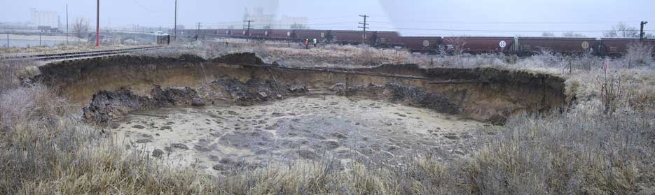
The new sinkhole formed in early January of this year near a Hutchinson salt plant. The sinkhole formed over a site where salt was mined by dissolving a subsurface salt layer with water and bringing the resulting brine to the surface. Salt beds here are about 400 feet deep and about 300 feet thick.
Because the sinkhole is relatively close to railroad tracks in the area, local and state agency officials and businesses are concerned that further development of the sinkhole might affect rail traffic.
According to Survey geophysicist Rick Miller, the Survey will collect data over two days, then process and interpret the data, reporting back to officials as quickly as possible. Survey scientists studied another sinkhole in the area that formed in 1990.
"We've been able to use seismic reflection methods in this area in the past," said Miller, "and they've been successful in giving us some sense of the extent of salt dissolution in the subsurface. In the case of this new sinkhole, we may be able to provide information that officials can use in making decisions about how to deal with the situation."
The Kansas Geological Survey is a research and service division of KU and is located on the university's west campus.
Photo courtesy of the Kansas Dept. of Health and Environment. A larger version is available.