![]()
Prev Page--Introduction || Next Page--Geology
Geography
Topography and Drainage
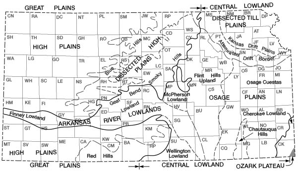
Wallace County lies within the High Plains section (Fig. 3) of the Great Plains physiographic province as designated by Schoewe (1949, p. 276). Physiographically much of the central part of the county differs somewhat from the High Plains of Kansas because the capping of unconsolidated sand, gravel, and silt of the Ogallala Formation (Tertiary) has been eroded by the South Smoky Hill River and its tributaries, exposing the older underlying Cretaceous rocks. The southern, northwestern, and north-central parts of the county, however, consist of broad, flat, rolling uplands, characteristic of the High Plains.
Figure 3--Map of Kansas showing physiographic regions. (From Schoewe, 1949.)
The highest point in Kansas is in Wallace County. It is a knoll near the Kansas-Colorado border, about 11 miles north of U. S. Highway 40. The altitude is 4,038.7 feet above sea level, according to elevation levels run in April 1962 by William A. Long and Melvin H. Franz of the Ground Water Branch of the U. S. Geological Survey. The location is 0.3 mile north and 0.1 mile west of the SE cor. sec. 12, T. 12 S.. R. 43 W. The second highest point. about 5 miles to the north, is approximately 4,022.7 feet above sea level and is about 200 feet east of the state line and 0.5 mile south of the NW cor. sec. 13, T. 11 S., R. 43 W.
The surface of the High Plains slopes gently eastward, and in Wallace County the average slope ranges from about 12 feet per mile in the southern part of the county to about 18 feet per mile in the northern part. The total topographic relief in Wallace County is about 885 feet. The lowest elevation, about 3,140 feet above sea level, is in the channel of the South Smoky Hill River on the eastern county line in the NE sec. 25, T. 13 S., R. 38 W. Shallow valleys having inconspicuous bluffs are the rule, although the south wall of the South Smoky Hill Valley in the eastern part of the county is rough and very prominent. Stream tributaries enter major streams at angles of 60° to 90°.
The major stream in Wallace County is the South Smoky Hill River, which rises about 30 miles west of the Kansas-Colorado border in Cheyenne County, Colorado, and flows eastward across Wallace County. The stream has a gradient of about 22 feet per mile across Wallace County, dropping from about 3,800 feet above sea level at the state line to about 3,140 feet at the eastern edge of the county. The width of the floodplain and the adjacent low terraces is about half a mile along most of its course but varies from a quarter of a mile to more than a mile. North Ladder Creek and Sand Creek are the principal streams in the southern part of the county. The valleys of these streams are narrow and their floodplains and terraces are poorly developed. Sand Creek joins North Ladder Creek in northeastern Greeley County. North Ladder Creek joins the Smoky Hill River in eastern Logan County.
Most of the smaller streams in Wallace County are tributaries to the South Smoky Hill River. The more important of these are Lake Creek, which drains much of the north-central and northeastern parts of the county, and Goose Creek and Willow Creek, which drain the northwestern part of the county. Rose Creek and Eagle Tail Creek drain part of the south-central part of the county and are the only streams of any consequence entering the South Smoky Hill River in Wallace County from the south. The North Smoky Hill River cuts across the extreme northeast corner of the county and joins the South Fork in Logan County, where they form the main stem of the Smoky Hill River.
The headward parts of several streams have cut into the Ogallala Formation and these spring-fed streams flow, especially after frost, from contributions from the Ogallala. Rose Creek heads 4 or 5 miles south of Sharon Springs and flows about 8 miles to its junction with the South Smoky Hill River about 6 miles east of Sharon Springs. A considerable amount of ground water is drained from the Ogallala by Rose Creek. Table 1 shows mean monthly discharges 1 mile upstream from the mouth of Rose Creek for the period from May 1946 to September 1953. In addition, an undetermined amount of water from Rose Creek is diverted for irrigation. It is reported that Rose Creek usually flows even in the driest summers.
Table 1--Monthly and yearly mean discharge, in cubic feet per second, 1 mile upstream from mouth of Rose Creek, for period of record.
| Water year |
Oct. | Nov. | Dec. | Jan. | Feb. | Mar. | Apr. | May | June | July | Aug. | Sept. | Yearly mean |
|---|---|---|---|---|---|---|---|---|---|---|---|---|---|
| 1946 | 3.52 | 2.98 | 1.79 | 0.69 | 2.46 | ||||||||
| 1947 | 4.10 | 4.24 | 4.35 | 4.0 | 4.56 | 9.15 | 5.72 | 7.98 | 5.18 | 2.77 | 2.31 | 2.54 | 4.7 |
| 1948 | 3.20 | 3.55 | 3.44 | 3.95 | 4.26 | 4.74 | 3.78 | 3.19 | 3.27 | 3.92 | 2.76 | 2.17 | 3.5 |
| 1949 | 2.6 | 3.4 | 3.5 | 3.1 | 3.4 | 3.1 | 5.8 | 7.1 | 15.5 | 2.8 | 18.1 | 7.9 | 6.4 |
| 1950 | 6.0 | 4.8 | 5.0 | 6.3 | 5.0 | 4.3 | 3.7 | 2.83 | 1.44 | 7.3 | 19.5 | 5.2 | 6.0 |
| 1951 | 4.4 | 4.3 | 4.7 | 5.5 | 4.8 | 3.3 | 5.2 | 4.8 | 10.6 | 7.5 | 4.7 | 3.9 | 5.3 |
| 1952 | 3.82 | 4.42 | 4.05 | 4.72 | 4.66 | 5.05 | 4.77 | 4.36 | 1.67 | 0.31 | 0.61 | 1.91 | 3.4 |
| 1953 | 2.44 | 2.38 | 3.70 | 3.92 | 3.70 | 3.41 | 4.16 | 2.79 | 0.94 | 0.22 | 6.67 | 0.56 | 2.9 |
Several other small tributary streams have cut headward into the Ogallala Formation, from which they derive water, and flow especially after frost, when transpiration by plants and evaporation is reduced. The more notable of these are Eagle Tail Creek and Willow Creek.
Lakes
Common features of the High Plains are shallow, undrained depressions and intermittent natural lakes. Several deep, steep-sided basins resulting from abrupt sinking of the ground also occur. Most of the depressions are circular to subcircular, although some appear to be linear and others have no particular pattern and may be designated as irregular in shape.
Dozens of undrained depressions characteristic of the surface of the High Plains are present in Wallace County. They range in size from a few tens of feet to nearly a mile in diameter. Some of the depressions appear to be grouped together. At some localities there appears to be an alignment of depressions; in places the alignments are along shallow valleys. In general there are three types: small, shallow depressions; large, deep depressions; and smaller, steep-sided depressions.
Most of the depressions in Wallace County are small and shallow, ranging in size from less than an acre to several tens of acres. After heavy rains, storm runoff collects in these depressions, forming temporary lakes. The water generally evaporates or seeps into the ground after a few weeks. The shallow depressions are referred to locally as "lagoons" or "buffalo wallows."
There are also several large, deep depressions, which range up to several hundred acres in size and contain water for many weeks or months after heavy rains. The large depressions were mapped from aerial photographs and are shown on Plate 1. The two largest are in the east-central part of the county where Tertiary rocks are not present, the largest one being in the southeastern part of T. 12 S., R. 38 W.
An abrupt sinking of the land, resulting in deep, steep-sided holes has also occurred at several places. Smoky Basin Cave-in, about 5 miles east of Sharon Springs in the SE sec. 33, T. 13 S., R. 39 W., is an example of an abrupt subsidence that occurred in 1926. Another well-known cave-in, referred to as Old Maid's Pool, is in the NE cor. sec. 30, T. 12 S., R. 40 W. This basin is perfectly circular and generally contains water at about out the same level.
Several theories have been offered as to the origin of the depressions of the High Plains. Darton and others (1915, p. 36-37) referred to some of the depressions as buffalo wallows and explained their origin by the combined action of buffaloes and wind. They believed that the depressions were started by buffaloes, either at wet spots or places of salt or alkali, and were enlarged by wind action and by the removal of mud by the animals after rains. Although this explanation might account for some of the small, shallow depressions in Wallace County, it does not seem adequate for the large depressions having depths of 10 feet or more.
Johnson (1901, p. 702, 712) considered the origin of the basins of the High Plains to be the result of solution of soluble beds followed by collapse in areas of Permian bedrock; however, he believed this hypothesis inadequate in areas of Cretaceous bedrock. He attributed the shallow undrained depressions of the uplands to rainwater accumulation in initially flat, uneven and undrained areas. The seepage of water beneath the pond caused settling of the underlying sediments by mechanical compaction and solution in the Tertiary rocks.
Johnson's ideas are supported by work done in Thomas County (Frye, 1945, p. 30), where test holes were drilled near the centers and rims of two depressions. The test holes disclosed that there was no reflection on the underlying Cretaceous bedrock of the surface depressions in the Tertiary rocks.
Russell (1929) observed the depressions in Wallace, Logan, and other counties in western Kansas and excluded the possibility of solution of the underlying Cretaceous rocks because of their relatively impervious nature. He explained the subsidences as resulting from collapse of cavities that developed between the walls of faults in the Niobrara Formation from late Pliocene and Early Pleistocene tensional faulting.
Elias (1931, p. 224-236) studied the subsidences and concluded that they were caused by solution of chalk along fault planes in the Niobrara Formation and subsequent collapse of cavities. He believed that some of the shallow depressions could be cave-ins of earlier origin, the surface expressions of which had been subdued by gradual filling and slumping of the walls.
Just as there is more than one type of depression so there could be more than one origin. Some of the depressions in Wallace County that are small and shallow could be accounted for either by Darton's buffalo wallow theory or Johnson's theory of compaction. However, for those depressions that are large and deep, Johnson's theory of compaction and solution of the Tertiary rocks seems applicable. It would seem that where Tertiary rocks are missing the large and relatively deep depressions must be explained by solution of the underlying rocks. Small, steep-sided depressions, such as Smoky Basin Cave-in and Old Maid's Pool, are the results of either solution of the Niobrara Chalk, probably along faults and fractured zones, or collapse within the Niobrara of cavities formed by tensional faulting. The uppermost rocks below the Niobrara that would be subject to solution would be about 2,000 feet below the land surface. Solution sufficient for collapse of large areas seems unlikely that far below the surface.
Climate
The climate of Wallace County is semiarid, with low to moderate precipitation and a high rate of evaporation. The weather during spring and fall is mild and generally pleasant. Much of the summer is hot, although the summer heat is moderated by brisk winds and low humidity and the nights are generally cool. As a rule the winters are reasonably mild; the periods of severe cold weather are short and the snowfall is relatively light. A large percentage of the winter days are clear, although snow flurries are common and occasionally the area is subjected to blizzard conditions. Ordinarily, snow remains on the ground only a short time.
In Wallace County the amount of precipitation and its seasonal distribution are the controlling factors in crop growth. Rainfall is erratic, coming sometimes as storms of 4 inches or more, and at other times in no appreciable amount for several weeks. According to data compiled from published records of the U. S. Weather Bureau, about 65 percent of the annual precipitation in Wallace County falls during the growing season of about 5 months (Fig. 4). The mean annual precipitation at Sharon Springs is 17.03 inches. The greatest annual precipitation recorded was 34.00 inches, in 1880; the least was 7.45 inches, in 1873 (Table 2). The average length of the season is 157 days. The average date of the last killing frost in spring is May 3, and that of the first killing frost in fall is October 7.
Figure 4--Normal monthly precipitation and average growing season in Wallace County.
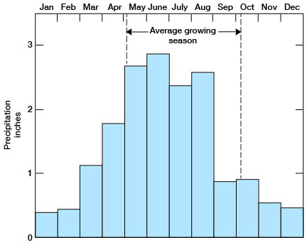
Table 2--Annual precipitation in Wallace County for period of record. Measurements from 1870 to March 1923 at Wallace, subsequent measurements at Sharon Springs. From published records of the U. S. Weather Bureau.
| Year | Precipitation, inches |
Year | Precipitation, inches |
|
|---|---|---|---|---|
| 1870 | 16.03 | 1916 | 10.60 | |
| 1871 | 20.89 | 1917 | 11.95 | |
| 1872 | 16.87 | 1918 | 20.37 | |
| 1873 | 7.45 | 1919 | 17.86 | |
| 1874 | 13.58 | 1920 | 14.85 | |
| 1875 | 16.45 | 1921 | 16.15 | |
| 1876 | 16.98 | 1922 | 12.58 | |
| 1877 | 14.22 | 1923 | 25.03 | |
| 1878 | 19.28 | 1924 | 10.93 | |
| 1879 | 16.58 | 1925 | 11.77 | |
| 1880 | 34.00 | 1926 | 10.32 | |
| 1881 | 8.82 | 1927 | 17.02 | |
| 1882 | 12.41 | 1928 | 22.27 | |
| 1883 | 23.35 | 1929 | 16.69 | |
| 1884 | 22.76 | 1930 | 23.49 | |
| 1885 | 21.01 | 1931 | 10.87 | |
| 1886 | 12.23 | 1932 | 15.71 | |
| 1887 | 19.57 | 1933 | 25.67 | |
| 1888 | 16.73 | 1934 | 9.40 | |
| 1889 | 14.55 | 1935 | 12.13 | |
| 1890 | 11.90 | 1936 | 1112 | |
| 1891 | 16.32 | 1937 | 12.36 | |
| 1892 | 17.65 | 1938 | 22.47 | |
| 1893 | 10.23 | 1939 | 13.02 | |
| 1894 | 9.54 | 1940 | 17.17 | |
| 1895 | 18.52 | 1941 | 24.35 | |
| 1896 | 14.26 | 1942 | 24.01 | |
| 1897 | 19.61 | 1943 | 13.39 | |
| 1898 | 15.16 | 1944 | 18.81 | |
| 1899 | 14.16 | 1945 | 15.89 | |
| 190O | 12.43 | 1946 | 17.65 | |
| 1901 | 16.51 | 1947 | 17.49 | |
| 1902 | 21.16 | 1948 | 18.74 | |
| 1903 | 17.23 | 1949 | 31.05 | |
| 1904 | 19.81 | 1950 | 13.92 | |
| 1905 | 27.01 | 1951 | 22.65 | |
| 1906 | 18.59 | 1952 | 15.01 | |
| 1907 | 8.85 | 1953 | 17.05 | |
| 1908 | 15.35 | 1954 | 12.53 | |
| 1909 | 20.20 | 1955 | 13.06 | |
| 1910 | 8.05 | 1956 | 8.16 | |
| 1911 | 8.95 | 1957 | 25.75 | |
| 1912 | 19.33 | 1958 | 20.74 | |
| 1913 | 8.57 | 1959 | 17.56 | |
| 1914 | 14.96 | 1960 | 17.35 | |
| 1915 | 28.31 |
Population
According to the census, Wallace County in 1960 had a population of 2,069. This is an average of 2.3 persons per square mile as compared to 26.6 person per square mile for the state as a whole. Sharon Springs, the county seat, had a population of 966. Other communities are Wallace, population 110, and Weskan, unincorporated.
Transportation
The Union Pacific Railroad crosses east-west near the middle of the county and passes through the towns of Wallace, Sharon Springs, and Weskan. U. S. Highway 40 crosses the county east-west and parallels the Union Pacific Railroad much of the way. Kansas Highway 27 crosses north-south near the middle of the county and passes through Sharon Springs. in addition, the county maintains many miles of section-line roads.
Agriculture
Agriculture is the dominant economic activity in Wallace County. According to the Kansas State Board of Agriculture (1959), the county in 1958 contained 327 farms, 283,000 acres in pasture, and 137,305 acres in crops harvested. Because of the practice of summer following, only a part of the cropland is in cultivation each year. The total value of field crops in 1958 was $4,894,930, and of livestock and poultry produced was $1,526,770. In January 1959 there were 25,000 cattle, 4,260 sheep, and 2,300 hogs in Wallace County. The acreage, production, and value of crops in Wallace County are given in Table 3.
Table 3--Acreage, production, and value of crops in Wallace County in 1958.
| Use | Acres planted | Acres harvested | Production, bushels | Value |
|---|---|---|---|---|
| Wheat | 81,000 | 70,000 | 1,820,000 | $3,094,000 |
| Sorghums | 51,000 | 49,000 | 1,112,100 | $1,405,700 |
| Barley | 7,700 | 6,500 | 110,500 | $76,700 |
| Hay | 5,900 | 10,800 (tons) | $124,700 | |
| Corn | 4,000 | 4,000 | 160,000 | $174,600 |
| Oats | 2,100 | 1,000 | 14,000 | $8,500 |
| Rye | 1,500 | 900 | 11,700 | $9,700 |
Mineral Resources
Mineral resources of Wallace County other than soil and ground water include sand and gravel, diatomaceous marl, natural gas, and volcanic ash.
Sand and Gravel--Sand and gravel are available in Wallace County from Pleistocene deposits along the South Smoky Hill Valley and from the Ogallala Formation in the uplands, where the deposits are extensive. The sand and gravel are used for concrete aggregate and for road construction and surfacing.
Diatomaceous Marl--Wallace County is the only county in Kansas where diatomaceous marl is mined. It is produced by the DeLore Division of the National Lead Company of St. Louis, Missouri. As described by the Kansas Geological Survey (1931), the diatomaceous marl is an impure variety of diatomite or diatomaceous earth, which is a hydrous or opaline form of silica composed principally of skeletal remains of microscopic, one-celled, fresh-water plants called diatoms. The Wallace County deposits contain flaky calcium carbonate, sponge spicules, and minor amounts of sand. The marl consists of about 20 percent silica and 80 percent calcium carbonate by weight. Because of the box shape of empty tests of diatoms, the percentage of the volume occupied by the tests is much greater than the percentage by weight. About one-half the deposits by volume is estimated to consist of diatoms. The deposits, which are as much as 11 feet thick, are found in the Ogallala Formation of Tertiary age, along the South side of North Smoky Hill Valley near the northeast corner of the county, mainly in secs. 10, 11, and 12, T. 11 S., R. 38 W,. The marl is snow white to grayish, light, and very fragile. The material is trucked to the company's processing plant at Edson in Sherman County, about 17 miles north of the mine, from where it is shipped by railroad cars. The deposits are estimated to exceed 1 million tons (Schoewe, 1959, p. 278). Kansas diatomaceous marl is used for a whiting substitute and as a paint filler.
Oil and Gas--Several wildcat wells have been drilled in Wallace County from time to time, but as yet oil in commercial quantities has not been produced. In 1956 gas was discovered on the Sexson lease in the SW sec. 19, T. 13 S., R. 42 W. The production zone was in rocks of Morrowan age (Early Pennsylvanian) at 5,008 to 5,014 feet. The well was assigned an initial potential of more than 14 million cubic feet of gas per day and was named the discovery well of the Sexson field. Because no pipeline connections were available, the well was shut in and no production has been reported from the field.
Volcanic Ash--A few deposits of volcanic ash occur in the Ogallala Formation in Wallace County. Although the ash is relatively clean, the deposits are not thick enough to be of commercial value. The thickest known deposit is in the SE cor. sec. 8, T. 14 S., R. 38 W., near the base of the Ogallala Formation. About 3 feet thick and fairly clean, the ash is exposed in a steep bluff under about 50 feet of overburden.
Prev Page--Introduction || Next Page--Geology
Kansas Geological Survey, Geology
Placed on web July 9, 2007; originally published November 1963.
Comments to webadmin@kgs.ku.edu
The URL for this page is http://www.kgs.ku.edu/General/Geology/Wallace/03_geog.html