![]()
Prev Page--Contents || Next Page--Geography
Introduction
Purpose and Scope of Investigation
This report gives the results of a study of the geology and the ground-water resources of Wallace County, Kansas. The study was designed to determine the quantity and quality of ground water in the county, to learn the geologic factors that control the occurrence of the water, and to serve as a guide to future ground-water development.
Nearly all water supplies in Wallace County are obtained from wells. Ground water is one of the county's principal natural resources, and although supplies are adequate for most uses in most of the county at the present rate of withdrawal, there is need for a better understanding of the quantity and quality of the available water supply in order to meet anticipated increases in water use.
According to Robert Hay (1891, p. 129), irrigation started in Wallace County when "in 1873 George Allman settled on the south bank of the Smoky Hill, a mile or two above Fort Wallace. One of the first improvements be made was to construct a ditch about a mile long, and by the aid of a small dam tap the first permanent water of that river. In proving up his claim, the dam, ditch, and laterals were among the improvements he described."
Irrigation has been practiced along the Valley of the South Fork Smoky Hill River (referred to in this report as the South Smoky Hill River) and in the upland in the southern part of the county for several years, and interest in irrigation has greatly increased in recent years. In the summer of 1958 there were 86 irrigation plants in Wallace County, most of which were drilled after 1951. By the summer of 1960 there were 10 additional irrigation wells, all in areas of considerable pumping. Further increased use of ground water for irrigation can be expected.
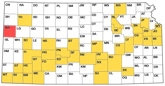
This study was made as a part of the ground-water program begun in 1937 by the State Geological Survey of Kansas and the U. S. Geological Survey, in cooperation with the Division of Sanitation of the Kansas State Board of Health and the Division of Water Resources of the Kansas State Board of Agriculture. The present status of the program is shown in Figure 1.
Figure 1--Index map of Kansas showing area described in this report and areas covered by other online geologic reports, as of July 2007. For additional information, please visit the KGS Geologic Maps of Kansas Page.
Location and Extent of Area
Wallace County is in the High Plains of northwestern Kansas, in the first tier of counties east of the Colorado border, and in the third tier of counties south of the Nebraska border (Fig. 1). The county is about 30 miles square, with an area of approximately 910 square miles.
Previous Investigations
A report was prepared by Hay (1895) on the geology and ground water of the area along the Kansas-Colorado line, including the northwestern part of Wallace County. A report on the progress of the Division of Hydrography for 1893 and 1894 (Newell,, 1895) contained records of 26 wells in Wallace County measured by Hay. Haworth contributed reports on the physiography of western Kansas (1897), on the physical properties of Tertiary rocks in Kansas (1897a), and on the geology of underground water and the possibilities of irrigation in western Kansas (1897b). Logan (1897) discussed the occurrence of Upper Cretaceous rocks in western Kansas. Williston (1897) described the Niobrara in western Kansas and also discussed (1897a) the Pleistocene deposits of Kansas. Johnson (1901, 1902) discussed the origin of the Tertiary of the High Plains and referred to the source, availability, and use of ground water in western Kansas. A report by Darton (1905) discussed the geology and ground-water resources of the central Great Plains, in which he treated the loess of western Kansas as a distinctly separate formation from the underlying Tertiary deposits. Darton also briefly discussed (p. 320) the water resources of Wallace County and speculated on the possible water supply in the Dakota Formation in the county. A report by Parker (1911) on the quality of water supplies in Kansas contained a brief description of the geology of Wallace County and analyses of samples of ground water (p. 195-196). In a special report on well waters in Kansas, Haworth (1913) discussed the Tertiary of western Kansas and its water-bearing characteristics. The work of Elias (1931) on the geology of Wallace County was an important contribution to the geology of western Kansas, and his study of the Ogallala Formation and Upper Pleistocene deposits was the foundation for later studies. Frye and Leonard (1952) made a study of the Pleistocene geology of Kansas. Cardwell (1953) reported on irrigation-well development in the Kansas River basin of eastern Colorado. The southern part of the area considered in Cardwell's report borders part of Wallace County. Ground-water studies in areas of Kansas which border Wallace County or include parts of the county, are Prescott (1953); Prescott, Branch, and Wilson ( 1954); Bradley and Johnson (1957); and Johnson (1958). Ail investigation of the geology and ground-water resources of Kit Carson County. Colorado, which borders about 6 miles of the northwestern edge of Wallace County, is in progress by George H. Chase of the U. S. Geological Survey district office in Colorado. Areas in Kansas where ground-water studies have been made, which have been published or are in preparation, are shown in Figure 1.
Methods of Investigation
The writer spent 4 months in the held during the summer and fall of 1957, about 2 months during the summer of 1958, and 1 month during the fall of 1960 gathering data upon which this report is largely based. The areal geology was mapped from field observations and from stereoscopic study of aerial photographs obtained from the U. S. Department of Agriculture. County maps prepared by the State Highway Commission of Kansas at a scale of 1 inch to the mile were used to record field data.
Data on 294 wells and 190 test holes were collected. Data on wells included the depth to water and the depth of the well. Most wells were measured by means of a steel tape graduated to hundredths of a foot. In a few wells measurements could not be made or were unreliable, and data on depth and water level for these wells were obtained from the owner or driller. Information concerning yield, adequacy of the supply, and quality of the water was obtained when possible from well owners. Drillers logs of wells and test holes were obtained when available from well owners and well drillers.
A total of 80 test holes were drilled in the county in conjunction with this investigation to determine the thickness and character of the Tertiary and Quaternary deposits. Of these test holes, 49 were drilled with a hydraulic rotary drilling machine and 31 with a jeep-mounted power auger, both owned by the State Geological Survey of Kansas. Well drillers and well owners provided logs of 51 irrigation wells, 1 domestic well, and 1 test hole. Logs of 32 shot holes were obtained from a seismograph party of Phillips Petroleum Company operating in the county during the summer of 1957.
Used in addition were logs of 18 test holes drilled and 4 test holes jetted in 1951 in conjunction with a ground-water investigation of the Ladder Creek area (Bradley and Johnson, 1957), and logs of 3 test holes near the Wallace-Sherman county line drilled in 1949 in conjunction with a ground-water investigation of Sherman County (Prescott, 1953).
Samples of water from representative wells were collected for analysis and were analyzed by Howard A. Stoltenberg, chemist, in the Sanitary Engineering Laboratory of the Kansas State Board of Health.
Locations of wells and test holes in the county were determined by means of an odometer and by aerial photographs. The altitudes of measuring points of wells and test holes were determined with a plane table and alidade. The base map used for Plate 1 was compiled from maps prepared by the State Highway Commission of Kansas.
Well-numbering System
The locations of wells, test holes, and local features in this report are designated according to General Land Office surveys in the following order: township, range, section, quarter section, quarter-quarter section, and quarter-quarter-quarter section (10-acre tract). The quarter sections, quarter-quarter sections, and 10-acre tracts are designated a, b, c, or d in a counter-clock-wise direction beginning in the northeast quarter section. For example, well 11-41-25acb is in the NW SW NE sec. 25, T. 11 S., R. 41 W. (Fig. 2).
If more than one well or test hole is located in the same 10-acre tract, the location letters are followed by serial numbers in the order in which they were inventoried. The location number of one inventoried well located in Colorado is preceded by the letter C.
Figure 2--Map of part of Wallace County illustrating the well numbering system used in this report.

Acknowledgments
The writer expresses appreciation to the many residents who gave permission to inventory their wells and supplied helpful information; to those who permitted their wells to be used for aquifer tests and who allowed access to their property for the study of rock exposures; and to the municipal officials who provided data concerning city water supplies. The following drillers furnished logs of wells and test holes and other information on wells in the county: Weishaar and Son, Scott City; Ben Hasz, Scott City; Jack Foust, Goodland; Kenneth Bogart, Godland; and A. E. Agnew, Weskan. Logs of seismograph shot holes were obtained from a Phillips Petroleum Company seismograph crew. The staff of the Soil Conservation Service, U. S. Department of Agriculture, and Ray Mann, County Agent, gave helpful information.
E. L. and Carrie Reavis and William Gellinger of the U. S. Geological Survey and the State Geological Survey of Kansas gave assistance during field work. The illustrations were drafted by Mary J. Kuminer.
The manuscript of this report has been reviewed by members of the U. S. Geological Survey and the State Geological Survey of Kansas; by Robert N. Smrha, chief engineer of the Division of Water Resources of the Kansas State Board of Agriculture; and by Dwight F. Metzler, chief engineer, and Willard O. Hilton, geologist, of the Division of Sanitation of the Kansas State Board of Health.
Prev Page--Contents || Next Page--Geography
Kansas Geological Survey, Geology
Placed on web July 9, 2007; originally published November 1963.
Comments to webadmin@kgs.ku.edu
The URL for this page is http://www.kgs.ku.edu/General/Geology/Wallace/02_intro.html