![]()
Prev Page--Geography || Next Page--Ground water
Geology
Summary of Stratigraphy
[Note: The geologic classification and nomenclature of this report follow the usage of the State Geological Survey of Kansas and differ somewhat from those used by the U. S. Geological Survey.]
The rocks cropping out in Sheridan County are sedimentary and are of Cretaceous (Gulfian), Pliocene, and Pleistocene age. The subdivisions and stratigraphic classification of these strata are given in Table 2 and in the cross sections in Figures 4A and 4B. The areal distribution of the outcrops is shown on the geologic map (P1. 1).
Table 2--Generalized section of geologic formations of Sheridan County, Kansas.
| System | Series | Formation | Stage | Thickness, feet |
Character | Water supply | |
|---|---|---|---|---|---|---|---|
| Quaternary | Pleistocene | Alluvium | Recent | 0-30 | Sand, gravel, silt, and clay; stratified or cross-bedded, unconsolidated. | Yields abundant supplies of water to wells along major streams and smaller supplies along tributaries. | |
| Undifferentiated valley deposits |
Recent and Late Wisconsinan |
0-40 | Includes undifferentiated late Wisconsinan terrace deposits, Recent alluvium, and colluvium. Contains silt and clay in upper part; interbedded silt, clay, sand, and gravel in lower part. | Yields moderate supplies of water to wells where sand and gravel is present. | |||
| Sanborn formation |
Terrace deposits |
Late Wisconsinan |
0-60 | Silt and clay; stratified, locally contains buried soil zones in upper part. Lower part contains sand and gravel and lenses of silt. | Yields moderate supplies of water to wells where sand and gravel is present. | ||
| Bignell silt member |
0-6 | Silt, massive, yellow-gray, well-sorted; blankets uplands in places. | Above water table; yields no water to wells. | ||||
| Peoria silt member |
Early Wisconsinan |
0-30 | Silt, massive, light-tan to light-gray, well-sorted; Brady soil at top. Generally mantles or underlies uplands. | Above water table; yields no water to wells. | |||
| Loveland silt member |
Illinoian | 0-16 | Silt, massive, tan to light-tan; Loveland soil at top. | Yields no water to wells. | |||
| Crete sand and gravel member |
0-55 | Sand, gravel, and silt. Borders major stream valleys. | Yields small to moderate supplies of water to wells where basal sand and gravel is present. | ||||
| Meade formation |
Sappa member |
Kansan | 0-20 | Silt and sandy silt. Locally contains volcanic ash deposits. | Lies above water table; yields no water to wells. | ||
| Grand Island member |
0-25 | Sand, gravel, and silt. | Lies principally above water table; yields no water to wells. | ||||
| Tertiary | Pliocene | Ogallala formation | 0-220 | Sand, gravel, silt, and clay interbedded and cross-bedded; in part cemented with calcium carbonate. Locally cemented with silica in lower part. | Yields large to moderate supplies of water over most of area. Lies in part above water table. | ||
| Cretaceous | Gulfian | Pierre shale |
0-375± | Shale, brown or black to yellow-gray; bentonitic, in part calcareous. | Yields no water to wells. | ||
| Niobrara formation |
Smoky Hill chalk and Fort Hays limestone members |
630± | Chalk and chalky shale, white to blue-gray. | Yields no water to wells. | |||
Figure 4A--Geologic cross sections through Sheridan County. A larger version of this figure is available.
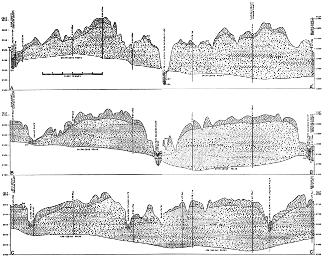
Figure 4B--Geologic cross sections through Sheridan County. A larger version of this figure is available.
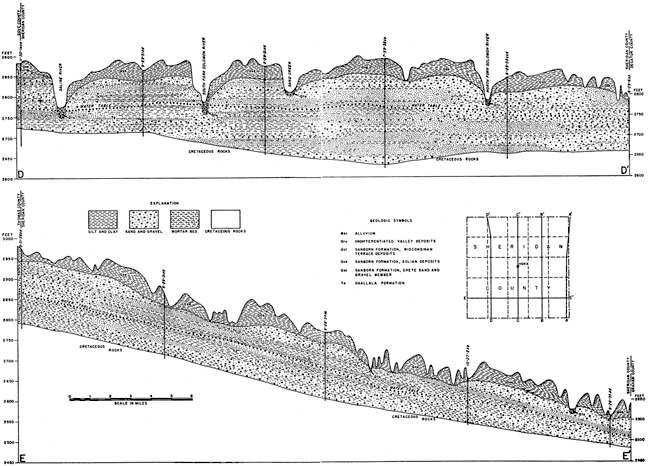
The Niobrara formation of late Cretaceous age underlies the entire county but crops out only in the valleys of Saline and South Fork Solomon Rivers in the extreme eastern part of the county. The Pierre shale underlies the western one-third of the county but does not crop out. The Ogallala formation of Pliocene age underlies all the county with the exception of narrow bands along the edges of the major valleys, and crops out along some of the major streams and their tributaries, particularly in the eastern part of the county. Deposits classified as the Meade formation of Pleistocene age (Kansan and Yarmouthian stages) occupy a relatively high position along the major valleys, and Crete terrace deposits of sand and gravel containing some silt lie at a lower position than the Meade formation along the lower parts of the major valleys. The upland area of the county is mantled by thick eolian silt, which is classified as a part of the Sanborn formation, and is divided into the Loveland, Peoria, and Bignell silt members. Deposits of eolian silt of late Wisconsinan age that are at least in part equivalent in age to the Bignell silt member underlie the more prominent terraces along the major stream valleys. There are low terrace deposits in the major valleys in about the eastern two-thirds of the county and Recent alluvium underlies the floodplains of the major valleys and their larger tributaries.
Geology in Relation to Ground Water
Cretaceous System--Gulfian Series
Niobrara Formation
Character--The Niobrara formation was named by Meek and Hayden (1862) for exposures of calcareous marl and chalky limestone near the mouth of Niobrara River in northeastern Nebraska. Logan (1897) described the Niobrara formation in north-central Kansas. He used a two-fold subdivision of the Niobrara formation consisting of the Fort Hays limestone and the Smoky Hill chalk members. Cragin had proposed the name Smoky Hill chalk earlier, and Williston proposed the name Fort Hays. The Niobrara formation in Sheridan County consists predominantly of chalky shale but also includes chalky limestone and chalk. The Fort Hays limestone, the lower member of the formation, does not crop out in the county, but drilling records indicate that the member is composed of massive beds of chalk and chalky limestone separated by thin beds of chalky clay shale. The thickness ranges from about 45 feet along the eastern edge of the outcrop east of Sheridan County to about 60 feet near the Colorado line.
The Smoky Hill chalk member of the Niobrara formation conformably overlies the Fort Hays limestone member and consists of soft beds of alternating chalk and chalky shale. Unweathered beds of chalk in the member are light to dark gray; weathered beds are white, tan, yellowish-pink, or brown. The member contains many thin beds of bentonite, and concretions of pyrite and limonite are common throughout. The lower part of the Smoky Hill chalk member is more massive and chalky and resembles the underlying Fort Hays limestone member. The uppermost part of the Smoky Hill chalk member has been silicified locally over much of northwestern Kansas and beds of silicified chalk were encountered in several test holes in Sheridan County. The siliceous cement probably was derived from the overlying Ogallala formation by solution of silica in percolating ground water and reprecipitation in the underlying chalk (Frye and Swineford, 1946).
Distribution and thickness--Although the Fort Hays limestone does not crop out in Sheridan County, it underlies the entire county. Oil-well logs indicate a uniform thickness of about 50 feet. The Smoky Hill chalk member crops out in Sheridan County only in the extreme eastern part along the valleys of the Saline and South Fork Solomon Rivers. The Smoky Hill chalk member underlies the entire county and reaches a maximum thickness of about 580 feet in the western part of the county. The minimum thickness is about 400 feet in the southeastern part of the county, the upper 150 to 200 feet of beds having been removed by pre-Ogallala and later erosion.
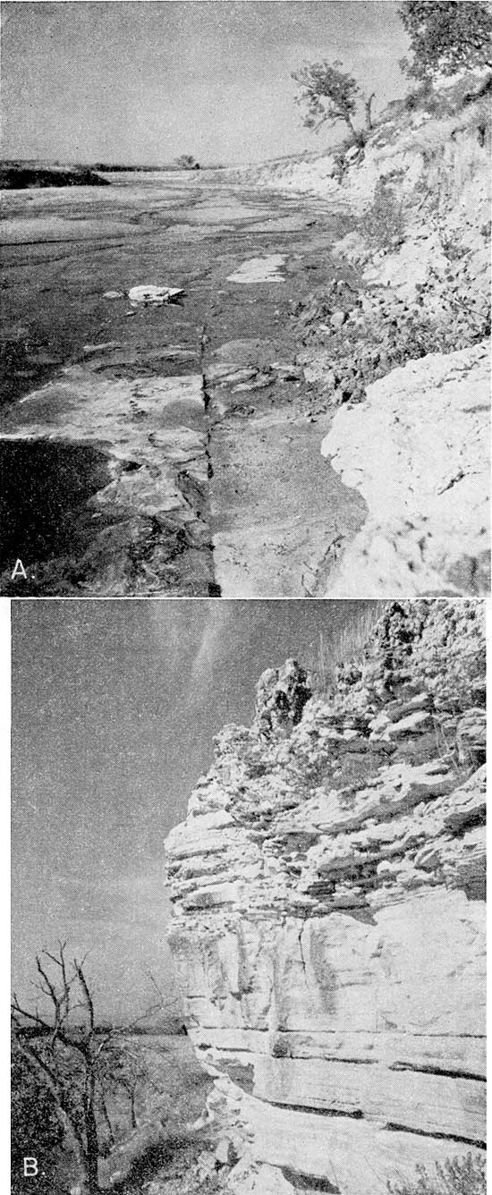
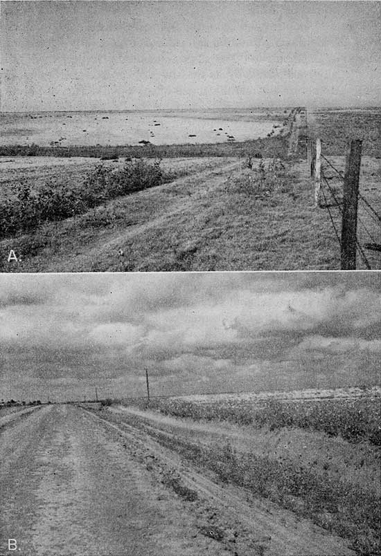
Water supply--The Niobrara formation is a poor aquifer in Kansas and it yields no water to wells in Sheridan County. The limestones and shales are relatively impervious and could yield water only from joints and seams (Pl. 3A). The uppermost part of the formation might yield water to wells locally from beds of silicified chalk, as these generally are fractured and jointed. The yield of wells tapping these beds would be small because the silicified chalk generally is relatively thin (Pl. 3B).
Plate 3--A, Jointing in Niobrara formation in bed of Saline River near center sec. 36, T. 10 S., R. 26 W. B, Silicified chalk at the top of the Smoky Hill chalk member of the Niobrara formation. The overlying rocks are "mortar beds" of the Ogallala formation.
Pierre Shale
The Pierre shale, which conformably overlies the Niobrara formation in northwestern Kansas, was named by Meek and Hayden in 1862 from exposures at old Fort Pierre in South Dakota. Elias (1931) described and named the several members of the Pierre shale in Kansas and discussed their correlation with later Cretaceous units of North America. The Pierre shale does not crop out in Sheridan County but it underlies the western one-third of the county. The weathered shale generally is greenish gray or brownish gray and is locally bentonitic, whereas the unweathered shale is predominantly dark gray or black. The thickness of the Pierre shale in Sheridan County ranges from a featheredge at its eastern limit to 375 feet in the northwestern part of the county. The formation yields no water to wells in Sheridan County, and in areas outside the county it supplies only meager amounts of highly mineralized water to wells.
Tertiary System--Pliocene Series
Ogallala Formation
The Ogallala formation was named by Darton (1899) for exposures near Ogallala in southwestern Nebraska. Elias (1931) made a detailed study of the Ogallala formation in Wallace County and adjacent areas in western Kansas.
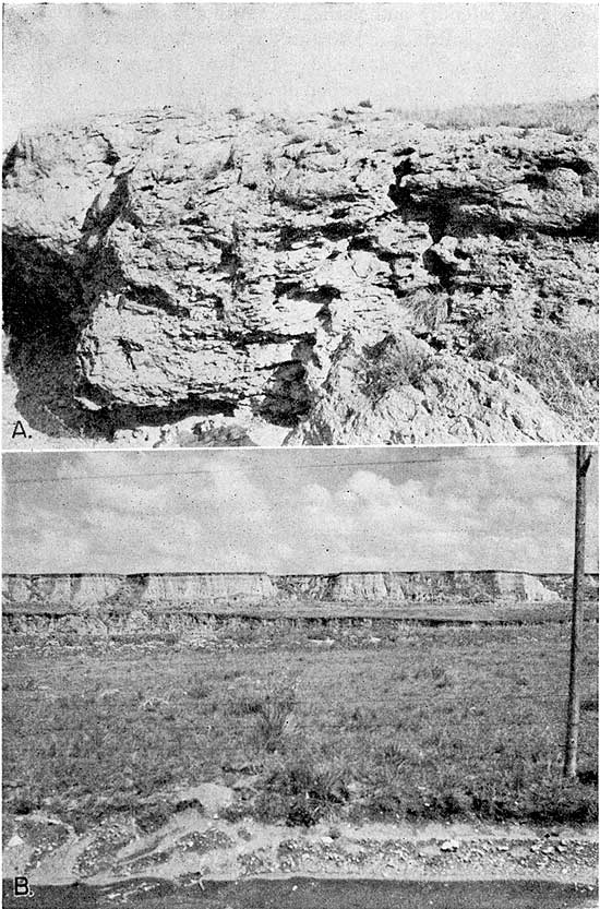
Character--The Ogallala formation in Sheridan County consists of a diversity of clastic sediments including sand, gravel, clay, silt, bentonitic clay, and locally, sandy and silty limestone and opal-cemented sand and gravel called "quartzite" and "caliche". The beds of sand and gravel and of clay within the formation are lenticular and grade from one lithologic type to another within short distances both laterally and vertically. Although the materials that make up the Ogallala formation are diverse, the pattern of outcrop is uniform and easily identified. The hard ledges generally are cemented with calcium carbonate and form rough weathered benches or cliffs. If the clastic materials of the Ogallala formation are cemented with calcium carbonate, they resemble mortar and are often called "mortar beds" (Pl. 4A). The thickness of the "mortar beds" ranges from a few inches to several feet, and the degree of cementation differs greatly within short distances. Sand is the principal constituent of the Ogallala formation and occurs at all horizons. The sand ranges in size from fine to coarse and may be found in beds of silt and clay, and in the "mortar beds". The logs of some of the test holes indicate the presence of some well-sorted sand in the Ogallala.
Plate 4--A, Typical "mortar beds" in the Ogallala formation in sec. 31, T. 8 S., R. 24 W. B, Sanborn formation. Crete sand and gravel member below Loveland silt member and silt of late Wisconsinan age. Loveland silt member forms bench about halfway down cliff. Crete sand and gravel member in vertical cut below Loveland silt member.
The State Geological Survey of Kansas classifies the Ogallala as a formation and recognizes three members, which, in ascending order, are the Valentine, Ash Hollow, and Kimball. The upper limit of the formation is marked in Kansas by a capping bed called the "algal limestone," which, except for small local deposits, has been removed from most of northwestern Kansas by post-Ogallala erosion. The algal limestone probably was deposited in shallow water-table lakes, whereas much of the calcium carbonate in "caliche" and in "mortar beds" probably was deposited at or near the water table. Changes in the water table within the formation may account for the position of "mortar beds" and "caliche" at various levels in the formation.
Distribution and thickness--The Ogallala formation was deposited by streams flowing generally eastward from the Rocky Mountain region. The streams carried heavy loads of material, and as the gradients and velocities decreased, the streams deposited their loads, filling their channels and forming broad floodplains. The floodplains were traversed by the aggrading streams and were built up by the deposition of debris until the streams crossed the low divides of the older Cretaceous rocks. The Ogallala formation originally covered most of the western half of Kansas, but subsequent erosion removed the deposits from much of the area. The thickness of the Ogallala formation ranges from a featheredge along its eastern limit and across some of the high ridges of Cretaceous rocks to more than 350 feet in the western part of the State.
The Ogallala formation was deposited over all of Sheridan County and now lies at or near the surface throughout the county except in the eastern part in the valleys of Saline and South Fork Solomon Rivers. The thickness of the Ogallala formation in Sheridan County ranges from a featheredge to as much as 220 feet in the west-central part of the county. The cross sections (Fig. 4) show that the Ogallala formation thins in the southern part of the county, owing in part to the higher altitude of the Cretaceous bedrock surface as shown in Figure 5 and in part to the removal of some of the deposits by erosion. The geographic distribution of the Ogallala formation is shown on Plate 1.
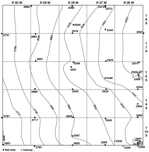
Figure 5--Map of Sheridan County showing configuration of the bedrock surface beneath the Ogallala formation, the location of test holes, and the altitude at which bedrock was encountered.
Water supply--The Ogallala formation is the principal aquifer in Sheridan County. The coarser materials that lie below the water table yield water freely to wells in the upland area of the county. All irrigation wells on the upland obtain their water from the Ogallala formation and those in the valleys obtain at least a part of their water from it. The finer-grained materials in the Ogallala formation may contain water, but because of their low permeability they generally yield only small quantities of water to wells. The thickness of the saturated material in the Ogallala formation differs considerably over the county as shown in Figure 8. All irrigation wells are in areas that have more than 40 feet of saturated material. The irrigation wells in the valleys, but which obtain water in part from the Ogallala formation, lie in areas that have between 40 and 60 feet of saturated material. Well 9-30-34ba is an old upland well that obtains all its water from the Ogallala formation. It did not penetrate the entire thickness of the Ogallala, but from 69 feet of saturated material the well was pumped at a rate of 300 gpm. Well 8-28-9ab is an upland well obtaining water from the Ogallala formation. There is 114 feet of saturated material at this well, which is pumped at a rate of 580 gpm with a drawdown of 63 feet. Data obtained from a study of the Ogallala formation in areas of outcrop and test drilling indicate that the Ogallala formation may be equally permeable in other parts of the county and that additional wells can be developed. The upland area in the north half of the county has the greatest thickness of saturated material (Fig. 8), but this area is also in general the area of greatest depth to water (Pl. 1). Wells of larger capacity probably can be constructed in the areas of greater saturated thickness, but costs would be correspondingly higher and pumping lifts would be greater, owing to the greater depth to water.
The quality of water from the Ogallala formation is generally better than that of water from the alluvium and terrace deposits. The chemical character of water from the Ogallala formation is shown in Table 3.
Table 3--Analyses of water from typical wells in Sheridan County, Kansas. Analyzed by Howard Stoltenberg. Dissolved constituents given in parts per million. [One part per million is equivalent to one pound of substance per million pounds of water or 8.33 pounds per million gallons of water.]
| Well number | Depth, feet |
Geologic source | Date of collection 1952 |
Temperature (°F) |
Dissolved solidsa |
Silica SiO2 |
Iron (Fe) |
Calcium (Ca) |
Magnesium (Mg) |
Sodium and potassium (Na+K) |
Bicarbonate (HCO3) |
Sulfate (SO4) |
Chloride (Cl) |
Fluoride (F) |
Nitrate (NO3) |
Hardness as CaCO3 | ||
|---|---|---|---|---|---|---|---|---|---|---|---|---|---|---|---|---|---|---|
| Total | Carbonate | Noncarbonate | ||||||||||||||||
| T. 6 S., R. 27 W. | ||||||||||||||||||
| 6-27-10ab | 90 | Terrace deposits | Nov. 14 | 56 | 400 | 32 | 0.74 | 77 | 20 | 38 | 346 | 38 | 21 | 0.6 | 3.1 | 274 | 274 | 0 |
| T. 6 S., R. 29 W. | ||||||||||||||||||
| 6-29-28da | 142 | Ogallala formation | Oct. 24 | 57 | 286 | 33 | .09 | 56 | 18 | 17 | 260 | 12 | 10 | .7 | 11 | 214 | 213 | 1 |
| T. 7 S., R. 27 W. | ||||||||||||||||||
| 7-27-11cd | 126 | Ogallala formation | Oct. 24 | 56 | 286 | 40 | .89 | 45 | 19 | 24 | 245 | 18 | 10 | 1.0 | 8.0 | 190 | 190 | 0 |
| T. 7 S., R. 30 W. | ||||||||||||||||||
| 7-30-18aa | 67 | Ogallala formation | Oct. 24 | 55 | 295 | 28 | 12 | 50 | 18 | 29 | 261 | 19 | 11 | 1.4 | 11 | 199 | 199 | 0 |
| T. 8 S., R. 26 W. | ||||||||||||||||||
| 8-26-1dd | 119 | Ogallala formation | Oct. 24 | 56 | 275 | 36 | 1.7 | 50 | 16 | 21 | 240 | 17 | 10 | .7 | 6.6 | 191 | 191 | 0 |
| T. 8 S., R. 27 W. | ||||||||||||||||||
| 8-27-14bd | 24 | Terrace deposits | Oct. 24 | 57 | 1,200 | 43 | .21 | 255 | 60 | 51 | 312 | 430 | 201 | .7 | 6.2 | 882 | 256 | 626 |
| T. 8 S., R. 28 W. | ||||||||||||||||||
| 8-28-9ab | 208 | Ogallala formation | Oct. 24 | 57 | 298 | 43 | .03 | 45 | 18 | 28 | 239 | 27 | 11 | 1.4 | 6.2 | 186 | 186 | 0 |
| T. 8 S., R. 29 W. | ||||||||||||||||||
| 8-29-14bc | 143 | Ogallala formation | Oct. 24 | 56 | 307 | 33 | .15 | 55 | 22 | 18 | 234 | 33 | 22 | 1.0 | 8.4 | 228 | 192 | 36 |
| T. 9 S., R. 26 W. | ||||||||||||||||||
| 9-26-23ba | 172 | Ogallala formation | Oct. 24 | 56 | 255 | 30 | .37 | 53 | 16 | 14 | 250 | 8.6 | 7.0 | .6 | 2.6 | 198 | 198 | 0 |
| T. 9 S., R. 28 W. | ||||||||||||||||||
| 9-28-5bc | 42 | Terrace deposits | Oct. 24 | 56 | 524 | 29 | .08 | 101 | 31 | 44 | 436 | 69 | 26 | 1.2 | 7.5 | 380 | 358 | 22 |
| 9-28-36dc | 98 | Ogallala formation | Oct. 24 | 57 | 266 | 22 | .59 | 53 | 16 | 20 | 249 | 17 | 8.0 | .9 | 6.2 | 198 | 198 | 0 |
| T. 9 S., R. 29 W. | ||||||||||||||||||
| 9-29-35ab | 126 | Ogallala formation | Oct. 24 | 57 | 282 | 28 | .83 | 43 | 18 | 30 | 235 | 24 | 14 | 1.3 | 7.5 | 182 | 182 | 0 |
| T. 9 S., R. 30 W. | ||||||||||||||||||
| 9-30-3aa | 140 | Ogallala formation | Oct. 24 | 57 | 267 | 25 | .02 | 46 | 19 | 22 | 244 | 15 | 11 | 1.6 | 7.5 | 193 | 193 | 0 |
| 9-30-23ad | 34 | Alluvium | Oct. 24 | 58 | 486 | 28 | .14 | 112 | 27 | 26 | 425 | 59 | 24 | .5 | .6 | 390 | 348 | 42 |
| T. 10 S., R. 26 W. | ||||||||||||||||||
| 10-26-19aa | 96 | Ogallala formation | Oct. 24 | 56 | 242 | 18 | 1.9 | 49 | 15 | 18 | 227 | 18 | 10 | .9 | 1.6 | 184 | 184 | 0 |
| 10-26-32ad | 32 | Terrace deposits | Oct. 24 | 56 | 540 | 31 | .05 | 104 | 25 | 52 | 393 | 81 | 41 | .6 | 11 | 362 | 322 | 40 |
| T. 10 S., R. 30 W. | ||||||||||||||||||
| 10-30-11dd | 130 | Ogallala formation | Oct. 24 | 57 | 277 | 19 | .79 | 47 | 18 | 28 | 242 | 23 | 13 | 1.3 | 8.8 | 191 | 191 | 0 |
| 10-30-30cb | 80 | Ogallala formation | Oct. 24 | 57 | 384 | 21 | .28 | 71 | 22 | 36 | 299 | 47 | 28 | .9 | 11 | 268 | 245 | 23 |
| a. Sum of determined constituents. | ||||||||||||||||||
Quaternary System--Pleistocene Series
Quaternary deposits in Kansas are of continental origin and are assigned to the Pleistocene series. They underlie much of the surface of the state and are composed of silt, clay, sand, gravel, and volcanic ash. The Pleistocene epoch as defined by the State Geological Survey of Kansas is the last of the major divisions of geologic time and has been called the "Ice Age," owing to the presence of continental glaciers in North America and elsewhere. The Pleistocene epoch has been divided into four main glacial stages, the Nebraskan, Kansan, Illinoian, and Wisconsinan; and three interglacial stages, the Aftonian, Yarmouthian, and Sangamonian. During the Nebraskan and Kansan stages, the continental glaciers entered northeastern Kansas and covered that area with glacial drift. During the Illinoian and Wisconsinan stages the continental glaciers did not reach the State, but the climatic changes accompanying their approach had a direct effect on deposits over much of Kansas.
Deposits of the Pleistocene epoch in Sheridan County and the rest of western Kansas are both fluviatile and eolian. The fluviatile (stream laid) deposits generally are associated with the present drainage systems or with ancient drainage systems, whereas the eolian deposits generally underlie the uplands but locally may extend into the valleys and may rest on older fluviatile deposits.
Fluviatile deposits of the Nebraskan stage underlie parts of central and southwestern Kansas and extend westward along Smoky Hill River and although they have not been identified in Sheridan County it is believed that they may be present in the county. Identification of these deposits in Sheridan County is difficult because they were principally derived from the Ogallala formation and their lithology is similar to that of the Ogallala.
The Aftonian interglacial stage followed the Nebraskan stage, and like the other interglacial stages it was marked by an unconformity in the geologic section that differs from the usual unconformity in that it represents a period of little erosion; conditions were stable and weathering was the principal agent at work. These conditions were conducive to development of soils on the surface of the older deposits. As no Nebraskan deposits have been observed in Sheridan County, soils developed on the Ogallala formation may be in part of Aftonian age.
The Meade and Sanborn formations were deposited in Sheridan County during the Kansan, Illinoian, and Wisconsinan glacial stages.
The Kansan glaciation was followed by the Yarmouthian interglacial stage during which climatic conditions were again stable and ideal for soil formation. The Yarmouthian stage is the interval of one of the major unconformities in the Pleistocene in Kansas. Although an extensive soil was developed during this stage, it was not recognized in deposits in Sheridan County. This soil, if formed, may have been removed by later erosion, but a part of the soil developed on the Ogallala formation in the county may be equivalent to the Yarmouth soil.
Meade Formation--Kansan and Yarmouthian Stages
The Meade formation was described in 1941 by Frye and Hibbard and was named for some deposits in central Meade County, Kansas. The Meade formation in Kansas is divided into two members, the lower (Grand Island) member, which is fluviatile and generally consists of sand and gravel, and upper (Sappa) member, which is partly fluviatile and partly eolian and generally consists of silt, sand, gravel, and locally of volcanic ash.
The Meade formation in Sheridan County underlies small areas in a high terrace position along the major streams. Only the Sappa member has been identified in the county and its identification was based on the presence of the Pearlette volcanic ash (Carey and others, 1952). The maximum thickness of the ash in the county is 16 feet in the NW sec. 34, T. 8 S., R. 28 W., in the valley of South Fork Solomon River. The Grand Island member of the Meade formation was not identified in Sheridan County, but in the SW sec. 4, T. 8 S., R. 25 W., Graham County, deposits of sand and gravel along the west side of Morland Lake are probably in the Grand Island member. The combined thickness of the Sappa and Grand Island members at this locality is about 25 feet. As this exposure is only about 2 miles east of the eastern border of Sheridan County it is likely that the deposits extend westward into Sheridan County. Identification of the Meade formation is difficult without the presence of distinctive fossils or the volcanic ash, and the terrace is not mappable because it is well dissected and younger deposits mantle the valley walls at the projected level of known deposits. No attempt was made to map the Meade formation in Sheridan County, as nearly everywhere in the county the younger eolian deposits mantle the level at which Meade deposits should occur. Pearlette volcanic ash deposits are shown on the geologic map (Pl. 1).
The Meade formation in Sheridan County is considerably above the water table and furnishes no water to wells.
Sanborn Formation
The Sanborn formation consists of six members. These members in ascending order are Crete sand and gravel, Loveland silt, early Wisconsinan terrace deposits, Peoria silt, Bignell silt, and late Wisconsinan terrace deposits.
The Sanborn formation developed during two glacial stages, the Illinoian and Wisconsinan, and one interglacial stage, the Sangamonian. Because of the difficulty in distinguishing between the silt members of the Sanborn formation, they were mapped as a unit (Sanborn eolian deposits), but the terrace deposits of early Illinoian (Crete) age and of late Wisconsinan age were mapped separately. The areas of the outcrop of the eolian deposits of the Sanborn formation and of the terrace deposits are shown on the geologic map (Pl. 1).
During the Illinoian glacial stage the continental glaciers were a relatively great distance from Kansas, but the accompanying climatic changes had a considerable effect on erosion and deposition in Kansas stream valleys. Subsequent to or contemporary with this fluviatile action, eolian deposits were laid down on the upland areas. Two members of the Sanborn formation were deposited during the Illinoian stage of glaciation, the Crete sand and gravel member, which is composed of interbedded silt, sand, and gravel of fluviatile origin, and the Loveland silt member, which is composed of silt and fine sand of both fluviatile and eolian origin. Both the Crete sand and gravel and the Loveland silt members of the Sanborn formation are recognized in Sheridan County.
The upper part of the Sanborn formation was deposited during the Wisconsinan stage of the Pleistocene in Kansas and consists principally of eolian deposits but includes some fluviatile terrace deposits in most of the valleys. The Wisconsinan stage has been divided into five substages in which the sequence of erosion and deposition is comparable to that of the earlier stages of the Pleistocene, but because of the remoteness of the glaciers, the effect on stream erosion and deposition was less pronounced than in the earlier stages. Glaciation in the Rocky Mountains was an important factor in the deposition of fluviatile materials in Kansas during the Wisconsinan stage. The Brady soil, formed during the Bradyan interglacial stage, lies on the Peoria silt member and is overlain by the Bignell silt member where the Bignell member is present. Where the Bignell silt member is absent the Brady soil merges into and is included with the modern soil.
The character of the Sanborn formation is indicated by the logs of test holes, by Plate 4B, and by the following measured sections.
| Measured section of the Sanborn formation along a steep cut on the south side of U. S. Highway 24 in the NW sec. 20, T. 8 S., R. 28 W. | Feet | |||
|---|---|---|---|---|
| Quaternary (Pleistocene) | ||||
| Sanborn formation | ||||
| 15 | Soil, dark brownish-gray (modern soil) | 0.4 | ||
| 14 | Silt, brownish-gray (Bignell silt member) | 1.2 | ||
| 13 | Clay and silt, dark-gray, blocky (Brady soil) | 1.0 | ||
| 12 | Silt, light-gray to buff; contains snail shells (Peoria silt member) | 14.1 | ||
| 11 | Clay, silty, dark-brown contains some caliche in nodules; soil zone heavy at bottom grading into Peoria above (Farmdale soil) | 2.8 | ||
| 10 | Gravel and pebbles on old erosional surface | 0.1± | ||
| 9 | Silt, limy, light-buff to white; contains some sand and gravel (top of Crete sand and gravel member) | 4.0 | ||
| 8 | Silt, tan to buff; contains some sand and gravel; less lime cementing than bed 9 | 5.0 | ||
| 7 | Silt, tan to buff; contains nodular caliche and caliche in burrows | 7.0 | ||
| 6 | Silt, tan to buff; contains much sand and gravel | 1.9 | ||
| 5 | Silt, tan to buff; contains some very fine sand | 4.1 | ||
| 4 | Sand, fine, silty, dark-buff | 0.7 | ||
| 3 | Sand and gravel, persistent stringer | 0.1 | ||
| 2 | Silt, light-gray to buff, some very fine sand and a few scattered ash shards | 4.5 | ||
| 1 | Sand and gravel (base of cut) | 0.6 | ||
| Total | 47.5 | |||
| Measured section of Sanborn formation in steep cutbank of Saline River in the NW sec. 33, T. 10 S., R. 26 W., 100 yards east of road. (Measured by C. K. Bayne, K. L. Walters, and A. R. Leonard) | Feet | |||
|---|---|---|---|---|
| Quaternary (Pleistocene) | ||||
| Sanborn formation | ||||
| 5 | Soil, dark gray-brown; lower 1 foot clayey, blocky, grades into underlying bed (modern and Brady soil) | 3.0 | ||
| 4 | Silt, gray to tan-buff; contains snail shells (Peoria silt member) | 14.0 | ||
| 3 | Silt, limy to very limy, upper part light-brown, lower part light-gray to white; possible weak soil zone in upper part, which forms bench (Loveland silt member) | 4.7 | ||
| 2 | Sand and gravel, crossbedded and lenticular; contains chalk fragments and clay balls, and a few snail and clam shells (Crete sand and gravel member) | 10.3 | ||
| 1 | Silt, sandy, poorly exposed | 12.2 | ||
| Total | 44.2 | |||
Crete sand and gravel member--Illinoian stage--The distribution of the Crete sand and gravel member of the Sanborn formation is shown on the geologic map (Pl. 1). The Crete in Sheridan County is in a terrace position along the major valleys. The terrace is dissected, discontinuous, and in a position higher than the younger Wisconsinan terraces but lower than the Meade formation. Younger eolian deposits overlie the Crete in some parts of Sheridan County with the result that the Crete is difficult to map except where it is exposed in steep banks or cuts. Plate 4B shows the Crete sand and gravel member overlain by the Loveland silt member and Peoria silt member, in the NW sec. 33, T. 10 S., R. 26 W. Where the Crete is below the water table in Sheridan County it furnishes water to a few wells. In a narrow strip along the valley of Saline River in southeastern Sheridan County where the Ogallala formation is thin, the Crete probably would yield moderate supplies of water to wells. Records of test holes drilled in Sheridan County indicate that the Crete may be as thick as 55 feet.
Loveland silt member--Illinoian and Sangamonian stages--The Loveland silt member of the Sanborn formation in Sheridan County consists primarily of eolian silt and was observed in many localities. The member is best exposed on slopes in the upland areas of the county where younger deposits have been removed by erosion. The Loveland consists of silt and small amounts of sand and colluvium in the lower part. The silt generally is tan or tan-brown in Sheridan County but eastward it is distinguished by a pronounced reddish color. The thickness of the Loveland in Sheridan County ranges from a featheredge to as much as 16 feet, and as the member generally lies above the water table it yields no water to wells in the county.
The upper limit of the Loveland member is marked by an unconformity resulting from a period of weathering in the Sangamon interglacial stage during which a soil with a well-developed profile was formed. The Sangamon soil is the most prominent fossil soil in western and central Kansas; it is much thicker than the modern soil and is exposed much more widely than the Yarmouth soil. The maximum thickness of the soil observed in Sheridan County was about 4 feet. The upper part of the soil, generally dark brown, grades downward into silt. Generally there is an accumulation of clay a short distance below the top of the soil and an accumulation of limy material at various distances below the clay.
The Loveland silt member was mapped with the eolian members of the late Wisconsinan deposits and they are shown on Plate I as Sanborn eolian deposits.
Peoria silt member--Wisconsinan stage--The Peoria silt member of the Sanborn formation is a uniform, generally fossiliferous, calcareous, massive silt. The deposit generally is buff to light-tan and is easily recognized by its massive appearance and its uniform color. The Peoria silt mantles much of the upland area of Sheridan County, and at the close of deposition of the Peoria the silt probably mantled the entire county with the exception of the lower parts of the valleys where the active streams removed the silt as it was deposited. The Peoria silt extends over the sides of the valleys and mantles the older terrace deposits. Plate 4B shows the Peoria on the Crete sand and gravel member in the valley of Saline River. The Peoria silt member in Sheridan County ranges in thickness from a featheredge to as much as 25 feet. The maximum thickness of the deposit probably never greatly exceeded 25 feet, but along the edges of the valleys the thickness probably was greater than at present as much of the Peoria silt member has been removed by erosion.
The Bradyan interglacial substage, which followed the period of deposition of the Peoria silt member of the Sanborn formation, was a period of relative stability during which deposition of eolian deposits ceased or was reduced to a rate such that a soil was formed. This soil, the Brady soil, although not as thick as the earlier Sangamon and Yarmouth soils, is recognized in many places in the upland areas of Sheridan County. It is commonly thicker than the modern soil and generally is dark-brown, but where it was formed under conditions of poor drainage it may be gray to black and generally has a thicker profile. The thickness of the Brady soil in Sheridan County is commonly about 1 foot but reaches a maximum of 3 feet (Pl. 5).
Plate 5--Views of the Brady soil in Sheridan County. A, Upland mantled with the Peoria silt member of the Sanborn formation. Dark line across draw and to left of trail is Brady soil. NW sec. 3. T. 11 S., R. 29 W. B, Brady soil below Bignell silt member of the Sanborn formation. SW sec. 21, T. 10 S., R. 26 W. Brady soil is dark zone below lighter silt in ditch.
The Peoria silt member of the Sanborn formation lies above the water table and yields no water to wells.
Bignell silt member--Wisconsinan stage--Thin discontinuous deposits of the Bignell silt member of the Sanborn formation are distributed widely over northwestern Kansas. The Bignell silt member generally resembles the underlying Peoria silt member in lithology and is separated from the Peoria silt by the moderately developed Brady soil. The Bignell may be identified by its contained molluscan fauna and under ideal stratigraphic conditions by its position.
The Bignell silt member in Sheridan County consists of discontinuous deposits of silt over much of the upland area. The silt is gray to light gray-brown. The Bignell silt member is of eolian origin as indicated by its topographic position and its lithology, and is the youngest upland eolian deposit in this area. In Sheridan County the thickness of the Bignell silt member ranges from a few inches to about five feet. Plate 5B shows the Bignell silt member overlying the Brady soil.
The Bignell silt member lies above the water table in Sheridan County and yields no water to wells.
Terrace deposits--Wisconsinan stage--In Sheridan County, as in much of northwestern Kansas, early Wisconsinan fluviatile deposits have not been identified, but a part of the lower deposits underlying the late Wisconsin terrace deposits in the stream valleys may be early Wisconsinan in age. In southwestern Kansas early Wisconsinan terrace deposits underlie late Wisconsinan terrace deposits in the Cimmarron River valley, and in Wallace County gravels of early Wisconsinan age underlie the Peoria silt member.
After the deposition of the Peoria silt member and in part contemporary with it, there was a period of valley filling during which nearly all major valleys in Kansas received sediments and during which the sediments underlying the wide, flat low terraces in the valleys in western and north-central Kansas were deposited. In Sheridan County these terraces range in width from a few hundred feet to about three-quarters of a mile. The thickness of these terrace deposits reaches a maximum of 60 feet as indicated by the records of wells and test holes drilled in the valleys.
A terrace that is equivalent in age to the low terrace in Sheridan County has been studied and mapped in the Prairie Dog Creek valley by Frye and Leonard (1949). The terrace is in the Republican River basin and was named the Almena terrace. The same terrace in the North Fork Solomon Valley has been named the Kirwin terrace (Leonard, 1952), and a similar terrace in the Smoky Hill Valley, in an equivalent position in relation to the river, has been called the Schoenchen terrace (Leonard and Berry, report in preparation). The Kirwin can be mapped as a continuous unit in the North Fork Solomon Valley from a point in Sheridan County downstream to the confluence with the South Fork Solomon Valley and thence up the South Fork to a point in central Sheridan County. Because this terrace is a continuous mappable unit throughout the valleys of North and South Forks of Solomon River, the name Kirwin terrace is used in this report. A low terrace in the Saline River valley in Sheridan County was mapped during this investigation. Its position relative to the river is comparable to that of the Kirwin and Schoenchen terraces but as it has not been traced downstream and as its relation to the other terraces has not been determined, no name is given to it in this report. The geographic distribution of deposits underlying the Wisconsinan terraces in Sheridan County is shown on the geologic map (Pl. 1).
The Wisconsinan terrace deposits in Sheridan County consist of sand, silt, and small amounts of clay and gravel. Where a sufficient thickness of sand and gravel lies below the water table, abundant supplies of water can be developed. Many stock and domestic wells derive water from Wisconsinan terrace deposits and two irrigation wells derive at least part of their water from these deposits.
Undifferentiated Valley Deposits
Undifferentiated valley deposits were mapped in Sheridan County along tributary streams and upper reaches of the valleys of the major streams. The geographic distribution of these deposits is shown on the geologic map (Pl. 1). The narrow band of Recent alluvium in the major valleys was difficult to show on the map because of the small scale. In the major stream valleys a point was reached upstream at which the margin of the Wisconsinan terrace became difficult to determine and in the tributary stream valleys the margins of alluvium, terrace deposits, and colluvium were difficult to determine. Because of the difficulty in mapping these deposits, which include Recent alluvium, Wisconsinan terrace deposits, and Recent colluvium, these deposits were mapped in one unit. The surface of the undifferentiated valley deposits over much of the area mapped is similar to the surface of the Wisconsinan terrace, but the heel, or side, of the terrace adjacent to the valley wall is difficult to determine because colluvial materials have moved down the valley wall to a broad U-shaped valley with the bottom of the "U" flattened. In general, these deposits are not entrenched into the underlying Cretaceous bedrock, as are the late Wisconsinan terrace deposits, but lie on the Ogallala formation.
The thickness of the undifferentiated valley deposits in Sheridan County ranges from a featheredge to as much as 40 feet in the major valleys. The deposits lie, in part, below the water table; and where there is a sufficient thickness of saturated gravel or sand, moderate supplies of water can be developed. Many domestic and stock wells in the county yield water derived, at least in part, from these deposits.
Alluvium
The Recent alluvium shown on the geologic map (Pl. 1) includes those deposits that are in the active channel of the streams and deposits that lie above the channel but below the level of the late Wisconsinan terrace. The areas underlain by Recent alluvium are subject to flooding, and new deposits of sand and silt are built up by each succeeding flood. The water table in the alluvium is continuous with the water table in the late Wisconsinan terrace deposits, and wells of moderate capacity can be developed in these deposits at shallow depths. Because of its small areal distribution, the alluvium is not one of the principal aquifers in Sheridan County.
Prev Page--Geography || Next Page--Ground water
Kansas Geological Survey, Geology
Placed on web Feb. 10, 2009; originally published May 1956.
Comments to webadmin@kgs.ku.edu
The URL for this page is http://www.kgs.ku.edu/General/Geology/Sheridan/04_geol.html