![]()
Prev Page--Introduction || Next Page--Geology
Geography
Topography and Drainage
Sheridan County is in the High Plains section of the Great Plains physiographic province. The county consists of nearly flat, gently rolling uplands dissected by valleys of the major streams. The upland surface declines eastward at an average rate of about 15 feet to the mile. The highest point in the county (2,900 feet) is in the westernmost part near Thomas County and the lowest point (about 2,250 feet) is in the valley of South Fork Solomon River near Studley.
The principal streams in Sheridan County are Saline, South Solomon, and North Solomon Rivers, and Sand and Prairie Dog Creeks. Saline, North Solomon, and South Solomon Rivers and Prairie Dog Creek rise southwest of Colby, in Thomas County. The North and South Forks of Solomon River and Prairie Dog Creek flow eastward and northeastward and Saline River flows nearly due east. Sand Creek rises in eastern Thomas County and flows due east to its junction with South Fork Solomon River in eastern Sheridan County. The eastward-flowing rivers are perennial through the eastern two-thirds of the county and are intermittent in the western third of the county. Their valleys are broad and relatively flat in the west part of the county, deepening as they progress. Like most of the east-west stream valleys in the northwestern part of the state, the valleys of these major east-west streams are asymmetric, the northward-flowing tributaries are more numerous but are shorter and have steeper gradients than the southward-flowing tributaries. The eastern third of the county is moderately well dissected for a distance of several miles from the main streams. The slopes are generally steep and the land is used primarily for grazing.
Climate
The climate of Sheridan County is dry subhumid to semiarid and is characterized by slight to moderate precipitation, moderately high wind velocity, and rapid evaporation. During the summer the days are hot, but the nights are generally cool. The hot weather in summer is moderated by good wind movement and relatively low humidity. The winters are generally characterized by moderate weather with severe cold periods of short duration and with relatively little snow.
The average mean temperature at Hoxie is 53.6° F. July generally is the hottest month with an average temperature of 78° F. and January generally is the coldest month with an average temperature of 29° F. The average length of the growing season is 161 days; the average date of the last killing frost is May 1 and of the first killing frost is October 11.
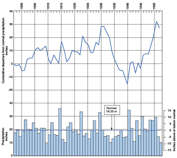
The normal annual precipitation at Hoxie is 19.35 inches. The greatest annual precipitation was 36.43 inches in 1915 and the least was 9.27 inches in 1910. Most of the precipitation falls during the growing season from April through September. The annual precipitation for the period of record and the cumulative departure from normal precipitation are shown in Figure 3.
Figure 3--Graph showing the annual precipitation and the cumulative departure from normal precipitation at Hoxie.
Population
According to the 1950 census, the population of Sheridan County was 4,607, which is an average of 5.2 persons per square mile as compared to 23.2 persons per square mile for the State. The population of the county has declined steadily since the 1930 census when the population was 6,038. Hoxie and Selden, with populations of 1,157 and 438 respectively, are the only cities in the county for which population figures are available. Although the county has declined in population, the cities have increased in population. About 20 percent of the people lived in the cities in 1930 whereas 34 percent lived in the cities in 1950. [Note: Sheridan County population was listed as 2,813 in 2000 U.S. census, with a density of 3.1 (32.9 for the state) (KU Institute for Policy & Social Research). Hoxie had a population of 1,244 and Selden 201 in 2000.]
Transportation
Sheridan County is served by the main line of the Chicago, Rock Island, and Pacific Railroad, which traverses the northwest corner of the county and passes through Selden, and by a branch line of the Union Pacific Railroad that crosses the county from east to west and passes through Hoxie. Several hard-surfaced Federal and State highways serve the county. U. S. Highway 24 crosses east-west through the middle of the county and Kansas Highway 23 crosses north-south through the middle of the county. U. S. Highways 83 and 383 parallel the railroad and extend through Selden. The rest of the county is served by county and township roads.
Agriculture
Agriculture is the chief occupation in Sheridan County and, according to the 1945 census, the county contains 739 farms comprising about 540,000 acres, of which about 201,000 acres is pasture or range land and about 339,000 acres is crop land. Because of the practice of summer fallowing a part of the cultivated land each year, the acreage harvested differs from year to year. Crops were harvested from 242,000 acres in 1947, 168,000 acres in 1948, 206,000 acres in 1949, and 177,000 acres in 1950. Wheat is the principal crop in the county, sorgums, hay, barley, and,corn following in order of acreage harvested. The acreages of the principal crops grown in 1950 are given in Table 1.
Table 1--Acreages of principal crops grown in Sheridan County in 1950.
| Crop | Acres |
|---|---|
| Wheat | 145,000 |
| Corn | 2,600 |
| Barley | 3,560 |
| Sorgums | 19,790 |
| Hay | 4,920 |
| Total | 175,870 |
Mineral Resources
The principal mineral resources of Sheridan County are oil, gas, construction materials, and volcanic ash.
Oil and gas--The first producing oil well in Sheridan County was drilled in 1943 although several dry holes were drilled prior to that time. The first production was in the Studley field from rocks of the Arbuckle group of Cambrian and Ordovician age. The Adell pool in northeastern Sheridan County was discovered in 1944, the Studley Southwest pool in 1945, and two other pools in 1952. Production of oil in Sheridan County in 1952 was 394,353 barrels from 47 wells. At the end of 1952 the cumulative production of oil in the county was 3,094,812 barrels. Wells formerly producing from the Arbuckle group in the county have been abandoned, and at the present time all production is obtained from the Kansas City and Lansing groups at a depth of about 3,800 feet. [Current information on the oil and gas resources of Sheridan County is available from the KGS website.]
Construction materials--Large quantities of sand and gravel are available for construction materials in Sheridan County, principally from the Ogallala formation. Lesser amounts of sand and gravel are available from terrace deposits and from alluvium along the principal streams. The sand and gravel in all the pits observed by the writer was suitable for use as road material, and that in several pits was suitable for concrete aggregate. Mortar beds of the Ogallala formation have been used for building blocks, but because of the difference in the hardness of the mortar beds, the blocks show differential weathering and are not as desirable for use in building as are other materials available in the vicinity of Sheridan County.
Volcanic ash--Volcanic ash consists of fine glass-like shards ejected during the explosive phase of a volcanic eruption. Four deposits of ash, two of which have been exploited, were observed in the county. The ash has been used as a mineral filler in road construction. For a more detailed discussion of volcanic ash and construction materials in Sheridan County, the reader is referred to the report by Beck and McCormack (1951).
Prev Page--Introduction || Next Page--Geology
Kansas Geological Survey, Geology
Placed on web Feb. 10, 2009; originally published May 1956.
Comments to webadmin@kgs.ku.edu
The URL for this page is http://www.kgs.ku.edu/General/Geology/Sheridan/03_geog.html