![]()
Prev Page--Geologic Formations || Next Page--Water Table
Ground Water
Explanation of Terms
The fundamental principles governing the occurrence of ground water have been discussed by many authors (Meinzer, 1923a; Moore, et al., 1940) and the reader is referred to their reports for a detailed discussion of the subject. These principles as they apply to Sedgwick County will be discussed in the sections that follow, and the following explanations of technical terms commonly used in describing ground water are presented as an aid to those not familiar with the subject. Most of the explanations are adapted from Meaner (1923b).
Aquifer--a rock formation, group of formations, or part of a formation that is water-bearing. Commonly used synonyms are ground-water reservoir, water-bearing bed, and water-bearing deposit.
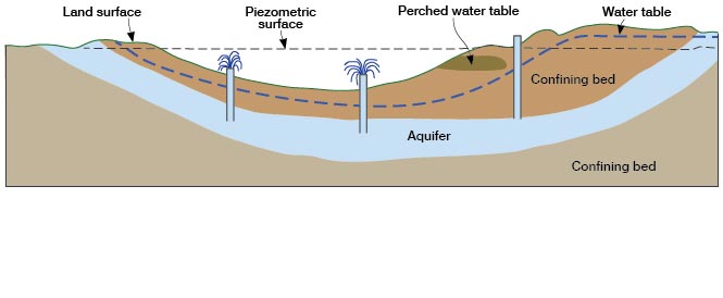
Artesian water--ground water under sufficient pressure to rise above the level at which the water-bearing bed is tapped in a well. The pressure is often called artesian pressure and the rock containing artesian water is called an artesian aquifer (Fig. 8)
Figure 8.—Sketch illustrating the occurrence of artesian and water-table conditions and a perched water table.
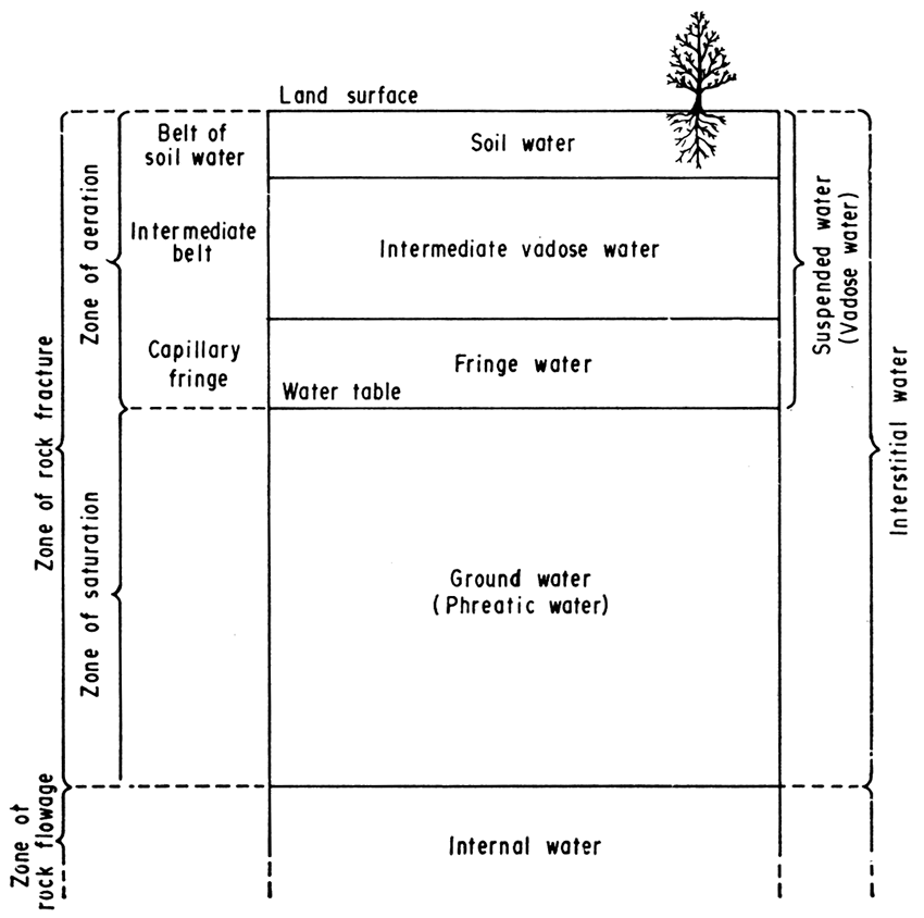
Capillary fringe--the zone directly above the water table in which water is held in the pore spaces by capillary action (Fig. 9)
Figure 9.—Diagram showing divisions of subsurface water (after Meinzer, 1923b).
Coefficient of storage--the coefficient of storage of an aquifer is the volume of water it releases from or takes into storage per unit surface area of the aquifer per unit change in the component of head normal to that surface.
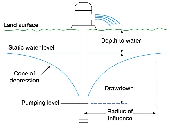
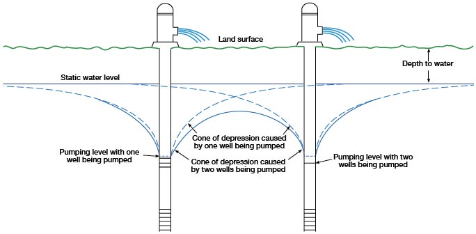
Cone of depression--a cone-shaped depression of the water table developed in the vicinity of a pumping well. Also called the cone of influence of a well (Fig. 10).
Figure 10.—Diagrammatic section of a pumping well showing drawdown, cone of depression, and radius of influence.
Confined water--water under artesian pressure.
Confining bed--a relatively less permeable rock layer that overlies or underlies an artesian aquifer and confines water in the aquifer under pressure (Fig. 8).
Draw down--the lowering of the water level in a well or nearby wells during pumping (Fig. 10).
Discharge--the removal of water from the zone of saturation.
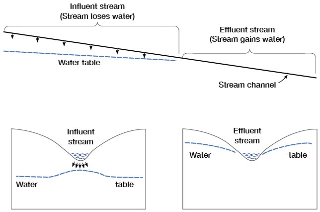
Effluent stream--a stream into which water is discharged from the ground-water reservoir, sometimes called a gaining stream (Fig. 11).
Figure 11.—Diagrammatic sections showing influent and effluent streams. Longitudinal section showing (right) how an effluent stream gains water and (left) how and influent stream loses water. Transverse section across influent part of a stream (lower left). Transverse section across effluent part of a stream (lower right). (After Meinzer, 1923a, fig. 26.)
Flowing well--an artesian well having sufficient head to discharge water above land surface (Fig. 8).
Ground water--water in the zone of saturation, or below the water table (Fig. 9).
Ground-water movement--the movement of ground water in an aquifer. The movement of ground water through an aquifer is extremely slow, generally on the order of inches per day or feet per year.
Hydraulic gradient--gradient of the water table measured in the direction of the greatest slope, generally expressed in feet per mile. The hydraulic gradient in an artesian aquifer is called the pressure gradient and is measured on the piezometric surface.
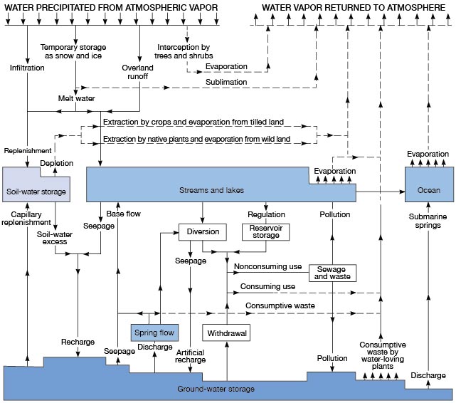
Hydrologic cycle--the complete cycle of phases through which water passes, commencing as atmospheric water vapor, passing into liquid and solid form as precipitation, thence along or into the ground, and finally returning to the form of atmospheric water vapor by means of evaporation and transpiration (Fig. 12).
Figure 12.--Diagram of the hydrologic cycle. Solid flow lines indicate movement of water as a liquid and broken lines movement as vapor. Heavy flow lines indicate man's principal interruption of the natural cycle (after Piper, 1953).
Hydrologic properties--the properties of an aquifer that control the occurrence and movement of ground water.
Hydrologic system--a series of interconnected aquifers.
Hydrostatic pressure--pressure exerted by water at any point in a body of water at rest. In an artesian system the hydrostatic pressure is the artesian pressure.
Impermeable rock--an impervious rock; that is, a rock through which movement of water is negligible under subsurface pressure differentials commonly found in nature.
Infiltration--the process whereby water enters the soil and moves downward toward the water table.
Influent stream--a stream that contributes water to the ground-water reservoir (Fig. 11).
Intermittent stream--a stream That flows only following precipitation or when receiving water from springs, ground-water seepage, or meeting snow.
Interstice--an opening or void in a rock. Interstices may be filled with any type of gas or liquid but in an aquifer are usually filled with water (Fig. 13).
Figure 13.—Diagram showing several types of rock intensities and the relation of rock texture to porosity. A. Well-sorted sedimentary deposit having high porosity; B. poorly sorted sedimentary deposit having low porosity; C. Well-sorted sedimentary deposit consisting of pebbles that are themselves porous, so that the deposit as a whole has a very high porosity; D. well-sorted sedimentary deposit whose porosity has been diminished by the deposition of mineral matter in the interstices; E. rock rendered porous by solution; F. rock rendered porous by fracturing. (From Meinzer, 1923a).

Mutual interference--the draw down caused in a pumping well by other pumping wells in close proximity. At any given point between two or more pumping wells the draw down will be the sum of the draw downs produced by each well at that point (Fig. 14).
Figure 14.—Diagrammatic section of two closely spaced pumping wells showing mutual interference between wells and the resulting cones of depression.
Non flowing artesian well--an artesian well in which the pressure is sufficient to cause the water level to rise above the top of the artesian aquifer but not above the land surface (Fig. 8).
Perched water--ground water separated from the underlying water by a zone of unsaturated rock. A perched water table is distinguished from the main water table (Fig. 8).
Perennial stream--a stream that flows continuously, such as the Little Arkansas River. (The Arkansas River is considered a perennial stream although on rare occasions it has been dry in some reaches.)
Permeable rock--rock that has a texture permitting water to move through it readily under pressure differentials ordinarily found in nature.
Permeability--the capacity of a rock to transmit water. The field coefficient of permeability of an aquifer may be expressed as the rate of flow of water at the prevailing temperature, in gallons a day, through a cross sectional area having a thickness of 1 foot and a width of 1 mile for each foot per mile of hydraulic gradient.
Piezometric surface--as generally used, the pressure indicating surface of an artesian aquifer.
Porosity--the ratio (expressed as percent) of the volume of openings in the rock to the total volume of the rock.
Recharge--the process by which water infiltrates and is added to the zone of saturation. Also used to designate the quantity of water added to the ground-water reservoir.
Runoff--the discharge of water by surface streams. It includes both surface-water runoff and ground-water seepage. Also used to designate the quantity of water discharged as runoff.
Specific capacity--the yield of a well generally expressed in gallons a minute per foot of draw down after a specified time of pumping.
Specific yield--the ratio of the volume of water a saturated rock will yield by gravity drainage to its own volume.
Storage--water stored in openings in the zone of saturation is said to be in storage. Discharge of water from an aquifer that is not replaced by recharge is said to be from storage.
Subsurface inflow--the movement of ground water into an area in response to a hydraulic gradient.
Transmissibility--the transmissibility of a rock is its capacity to transmit water under pressure. The coefficient of transmissibility is the field coefficient of permeability multiplied by the saturated thickness, in feet, of an aquifer.
Transpiration--the process by which water vapor is given off into the atmosphere by living plants.
Prev Page--Pleistocene || Next Page--Water Table
Kansas Geological Survey, Geology
Placed on web Nov. 1998; originally published Dec. 1965.
Comments to webadmin@kgs.ku.edu
The URL for this page is URL=http://www.kgs.ku.edu/General/Geology/Sedgwick/gw01.html