![]()
Prev Page--Introduction || Next Page--General Geology
Geography
Topography and Drainage
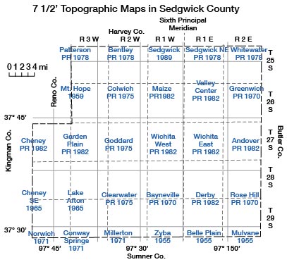
Sedgwick County, with the exception of the northeast corner, lies within the Arkansas River Lowlands section of the Central Lowland physiographic province (Schoewe, 1949). The location of the county with respect to other physiographic areas of the State is shown in Figure 3. The topography of the county is characterized by the extreme flatness of the broad Arkansas River valley and the gently rolling slopes rising to the uplands adjacent to the valley. The highest point in the county, about 1,540 feet above sea level, is on its west edge, about 5 miles southwest of Andale. The lowest point, about 1,220 feet above sea level, is where the Arkansas River leaves the county to the south. Modern 7 1/2-minute topographic maps are available for all of the county [as of Jan. 1998] (Fig. 4).
Figure 3—Map of Kansas showing physiographic divisions (from Schoewe, 1949).
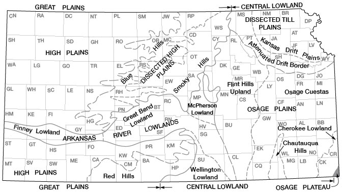
Figure 4—Outline map of Sedgwick County, Kansas, showing areas covered [1998] by modern 7 1/2-minute quadrangle topographic maps. Names are official quadrangle names of the U.S. Geological Survey and dates are those of last revision of sheets.
Drainage of the county is by way of the Arkansas River and its tributaries. The Arkansas River enters the county at the north-west corner, flows in a southeasterly direction to a point north of Wichita where it turns south, and leaves near the southeast corner. The Little Arkansas River enters the county near the center of the north boundary, flows east-southeast, and joins the Arkansas River at Wichita. South of the Arkansas River. drainage is by Big Slough, Cowskin Creek, the Ninnescah River. and all their tributaries. Big Slough and Cowskin Creek head in the northwestern part of the county and parallel the course of the Arkansas to join it near Derby and in northeast Sumner County, respectively. The North Fork and South Fork Ninnescah rivers join in the southwestern part of the county to form the Ninnescah River which flows to the southeast and leaves the county near Clearwater. A narrow strip along the eastern edge of the county, ranging in width from 6 miles at the north county line to 1 mile at the south county line, is drained by east-flowing tributaries of the Walnut River.
Much of the flat land adjacent to the Arkansas River is very poorly drained, and artificial drains have been installed on much of the agricultural land. An extensive flood diversion system has been constructed around Wichita to alleviate recurrent flooding of urban areas by the Little Arkansas and Arkansas rivers and their tributaries. (See Pl. 1.)
Climate
The following climatic data were compiled from a 72-year record of the U.S. Weather Bureau for the Wichita station and are presented as an aid in interpreting and correlating water-level fluctuations due to weather phenomena.
Sedgwick County lies in the path of warm, moist air masses moving northward from the Gulf of Mexico that alternate with cold, dry air moving southward from the polar regions. Consequently, the weather is subject to frequent abrupt changes. Summers are generally hot. and strong, southerly winds are common. Winters are usually mild, but snow flurries are common, with snow usually remaining on the ground for a short time only. The mean annual temperature at Wichita is 57° F and has ranged from -22 degrees F on February 12, 1899, to 114 degrees F on July 12, 1936. The average date of the first killing frost in the fall is October 31 and of the last killing frost in the spring April 6, with an average growing season of 208 days.
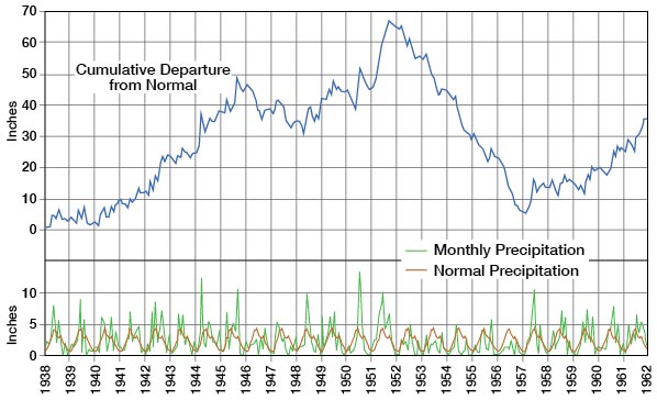
The normal annual precipitation in Wichita is 30.70 inches (period of record 1921-1950). Most of the precipitation falls during the growing season in the form of brief, heavy thunderstorms. The distribution of precipitation throughout the year and from year to year is quite irregular. The wettest year on record at Wichita was 1951 when 50.48 inches of precipitation were recorded. The driest year on record was 1956 when only 12.73 inches were recorded. The monthly precipitation, normal monthly precipitation. and cumulative departure from normal precipitation for the Wichita station are shown in Figure 5.
Figure 5—Monthly precipitation, normal monthly precipitation, and cumulative departure from normal precipitation at Wichita, Kansas.
Population
Sedgwick County contains about 15.7 percent of the State's population and has been an area of rapid growth in the past two decades. The County was organized in 1870 when it had a population of 1,095, and by 1960 it had a population of 343,231, according to records of the Bureau of the Census. About 91 percent of the county's population is classed as urban and most are inhabitants of Wichita. Table I gives the population of Wichita since the year 1880 as reported by the Bureau of the Census.
Agriculture
In 1959 there were about 2,150 farms in Sedgwick County with 376,190 acres in cropland. Small grain farming, raising of livestock, and dairying are the principal agricultural pursuits in the county. Wheat is the principal crop raised, and in 1959 the county ranked third in the State in wheat production, second in barley, and sixth in grain sorghums.
Mineral Resources
The mineral resources of Sedgwick County in addition to ground water include oil, gas, salt, gypsum, sand, and gravel. The distribution of the mineral resources of the county other than ground water is shown in Figure 6.
Figure 6—Map of Sedgwick County, Kansas, showing distribution of mineral resources other than ground water.
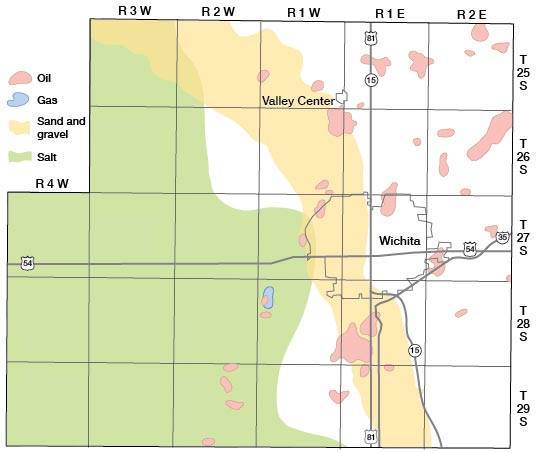
Oil and gas—Oil was first discovered in the county in 1928 when a well 3,367 feet deep located in sec. 12, T 26 S, R 1 W was completed in the Viola Limestone of Middle Ordovician age. Development in the county has continued, and in 1960 oil and gas were being produced from 631 wells. The cumulative production in Sedgwick County has been 72.76 million barrels of oil and 2.26 billion cubic feet of gas. The cumulative production, number of wells, producing zones, and depth to producing zones for all fields in the county are given in annual reports by the Oil and Gas Division, State Geological Survey of Kansas.
Salt—Salt deposits in the Wellington Formation of early Permian age underlie about the western half of Sedgwick County. The deposits range in thickness from a featheredge near the center of the county to about 300 feet along the western edge. They are interbedded with thin shale's, anhydrite, and limestone. Salt is being extracted for use as a raw material by a chemical company near Wichita. Originally the salt was extracted as a natural brine from a solution zone along the eastern margin of the salt beds. Current salt production is from brine which is artificially produced by water injection into wells located in the southwestern part of the county.
Gypsum—The presence of gypsum and anhydrite in the Wellington Formation east of the Arkansas River valley in Sedgwick County has been known for many years and was reported originally by Grimsley and Bailey (1899, p. 68). A gypsum deposit northeast of Mulvane was worked commercially from 1899 to 1901, but there has been no commercial production of gypsum in the county since that date. Little information is available concerning the extent and quality of the gypsum in the county, but it is thought to be present in much of the area east of the Arkansas Valley.
Sand and gravel—Sand and gravel deposits of Pleistocene age underlie about one-third of the county and have been worked commercially for many years. Most of the pits are located near the Arkansas and Little Arkansas rivers where the overburden is thin. The water table is shallow adjacent to the rivers, and the sand and gravel is quarried hydraulically. These are used extensively for concrete aggregate and as road metal. The location of active sand and gravel pits in the county is shown on Plate 1.
Industries
The metropolitan area of Wichita is the most heavily industrialized area in the State and is the most important transportation and distribution center. The area is nationally prominent in the manufacture of military and private aircraft. Other important industries include the production and refining of petroleum products, chemical manufacture, the milling, and storage of rain. meat packing, metal fabrication, and the manufacture of foundry products.
Prev Page--Introduction || Next Page--General Geology
Kansas Geological Survey, Geology
Placed on web Nov. 1998; originally published Dec. 1965.
Comments to webadmin@kgs.ku.edu
The URL for this page is http://www.kgs.ku.edu/General/Geology/Sedgwick/geog01.html