![]()
Prev Page--Geology || Next Page--Ground Water
Geology and Water Supply of Rock Units
Rocks that are significant to the water supply in Rush County range in age from Permian to Pleistocene. A generalized section of the rocks and their water-bearing characteristics is given in table 2.
The subsurface Permian and Cretaceous rocks are discussed because of their potential future utilization as aquifers or as confining beds below which brine and other liquid wastes might be disposed. When desalinization processes become more economical and more water is needed in central Kansas, the deeper aquifers could be utilized.
Table 2--Generalized section of geologic units and their water-bearing characteristics.
| System | Series | Group | Formation or stratigraphic unit |
Member | Thickness (feet) |
Character | Water Supply1 |
|---|---|---|---|---|---|---|---|
| Quaternary | Pleistocene | Undifferentiated deposits |
0-56 | Eolian, fluvial, and colluvial deposits; mostly silt that may overlie sand and some gravel. | May yield small to moderate quantities of water to wells. | ||
| Valley-fill deposits |
0-120 | Fluvial and eolian deposits of gravel, sand, silt, and clay. | May yield moderate to large quantities of water to wells in Walnut Creek valley and small to moderate quantities of water to wells in other valleys. | ||||
| Terrace deposits |
0-70 | Fluvial and eolian deposits comprised of gravel, sand, silt, and clay. | May yield small to moderate quantities of water to wells. | ||||
| Tertiary | Pliocene | Ogallala Formation |
Kimball | 0-44 | Fluvial deposits of gravel, sand, silt, and clay; occurrences of soil caliche (referred to as "algal limestone") and quartzitic-appearing green conglomerate with an opaline matrix. | Occurs on divide areas and is not known to yield water to wells. | |
| Ash Hollow | |||||||
| Valentine | |||||||
| Cretaceous | Upper Cretaceous |
Colorado | Niobrara Chalk |
Fort Hays Limestone |
0-10 | Marine deposits of massive chalky limestone. | Yields no water to wells. |
| Carlile Shale | Codell Sandstone |
0-300 | Marine deposits of chalky limestone and chalky shale, overlain by virtually noncalcareous shale containing large concretions, overlain by friable silty sandstone. Contains numerous bentonite beds. | Not known to yield water to wells. | |||
| Blue Hill Shale |
|||||||
| Fairport Chalk |
|||||||
| Greenhorn Limestone |
Pfeifer Shale | 0-100 | Marine deposits of alternating chalky limestone and chalky shales; contains bentonite beds. | Not known to yield water to wells. | |||
| Jetmore Chalk |
|||||||
| Hartland Shale |
|||||||
| Lincoln Limestone |
|||||||
| Graneros Shale |
0-40 | Marine deposits of gray to black noncalcareous to slightly calcareous silty shale with sandstone lenses and bentonite beds. | Not known to yield water to wells. | ||||
| Lower Cretaceous |
(note Lower Cretaceous boundary is within Dakota) |
Dakota Formation |
Janssen Clay |
200-300 | Some marine but primarily non-marine deposits of massive white to brown clay, silt, and shale. Contains interbedded lenticular sandstone and lignite. | Yields small to moderate quantities of water to wells. | |
| Terra Cotta Clay |
|||||||
| Kiowa Formation | 100-125 | Marine deposits of thinly laminated gray to black shale with sandstone lenses and thin limestone beds in lower part. | Not known to yield water to wells. | ||||
| Cheyenne Sandstone |
25-100 | Some marine but primarily non-marine deposits of buff to gray sandstone with some shale. | Not known to yield water to wells. | ||||
| Permian | Lower Permian |
Nippewalla | Dog Creek Formation |
600-700 | Marine deposits of red siltstone and sandstone with some shale and gypsum. | Not known to yield water to wells. | |
| Blaine Formation |
|||||||
| Flower-pot Shale |
|||||||
| Cedar Hills Sandstone |
|||||||
| Salt Plain Formation |
|||||||
| Harper Sandstone |
|||||||
| Sumner | Stone Corral Formation |
20-30 | Marine deposit of principally anhydrite. | Yields no water to wells. | |||
| 1. In this report, small quantities refers to yields generally less than 10 gpm, moderate quantities to 10 to 500 gpm, and large quantities to greater than 500 gpm. | |||||||
Permian System-Lower Permian Series
Sumner Group
Stone Corral Formation
The Stone Corral Formation was named from exposures in and near sec. 11, T. 20 S., R. 6 W., Rice County, Kans., by Norton (1939, p. 1775). Many geologists refer to the Stone Corral as the "Cimarron anhydrite." The Stone Corral is the upper formation of the Sumner Group.
Lithology, distribution, and thickness--At the type section in Rice County, the Stone Corral is a massive 6-foot ledge of cellular dolomite with some dolomitic shale that forms a prominent scarp (Norton, 1939, p. 1777). The amount of shale increases southward to such an extent that the formation is hardly recognizable in Kingman County (Merriam, 1963). The formation is represented by scattered dolomite rhombs in silty shale in Harper County (Swineford, 1955). The Stone Corral is present in the subsurface westward from Harper County on the south to Jewell County on the north. It is easily discernible with electric logs and is an important marker bed in petroleum exploration. The thickness of the formation in the subsurface is generally between 25 and 45 feet, but in Scott County it is 100 feet thick (Norton, 1939, p. 1781). The Stone Corral in Rush County is between 20 and 30 feet thick. Depth to the Stone Corral in Rush County, as determined from electric and radioactive logs, ranges from about 900 to 1,550 feet. Figure 7 is a map showing the approximate depth to the top of the Stone Corral in Rush County.
Figure 7--Depth to top of Stone Corral Formation.
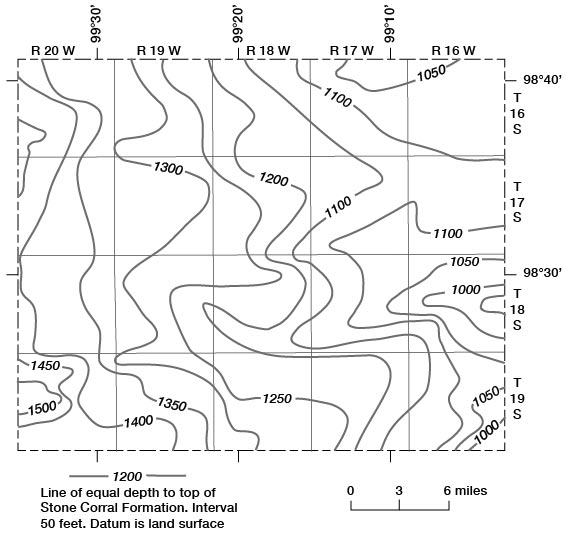
Water supply--The Stone Corral is not known to contain water in Rush County; rather, it is regarded as a barrier to the movement of water. Below the Stone Corral, brine and other wastes might be disposed with relatively little chance of leakage upward into higher formations.
Nippewalla Group
The Nippewalla Group, which was named by Norton (1939, p. 1782), included several hundred feet of red beds between the Stone Corral and Blaine Formations. The State Geological Survey of Kansas (Zeller, 1968) now includes the following formations, in ascending order, in the Nippewalla Group: Harper Sandstone, Salt Plain Formation, Cedar Hills Sandstone, Flower-pot Shale, Blaine Formation, and Dog Creek Formation.
Lithology, distribution, and thickness--The Nippewalla Group consists of siltstone and very fine grained sandstone, with minor quantities of silty shale and gypsum (Swineford, 1955). The group crops out in central and south-central Kansas and is in the subsurface in the western half of the State. The thickness of the Nippewalla in Kansas is reported to be approximately 930 feet by Moore and others (1951, p. 38), from 610 to 870 feet with an original thickness possibly greater than 1,000 feet by Lee (1953, p. 5), and through addition of formation thicknesses from 869 to 948 feet by Swineford (1955). In Rush County the thickness of the Nippewalla probably ranges from 600 to 700 feet.
A study of numerous electric and radioactive logs and some sample logs from Rush County and surrounding counties indicates that the Nippewalla is difficult to subdivide into the accepted stratigraphic sequence. The Harper Sandstone and Salt Plain Formation were not differentiated in this study. What is tentatively called Cedar Hills Sandstone in this report coincides with a subdivision picked as Cedar Hills by the Kansas Sample Log Service and described lithologically as "amber and orange-pink, rounded, polished, friable, fine to coarse, free-drilling sandstone, and shaly sandstone." Lee (1953) described the Cedar Hills in the subsurface as ". . . red sand and siltstone interstratified with silty shale. The sandstones, which are medium- to fine-grained, are in the main orange colored and include many polished subrounded grains slightly coarser than the more angular particles in which they are embedded. Because the sandstone crumbles easily, coherent fragments are rare in the cuttings." Figure 8 is a map showing the depth to the top of the Cedar Hills Sandstone in the county.
Figure 8--Depth to top of Cedar Hills Sandstone.
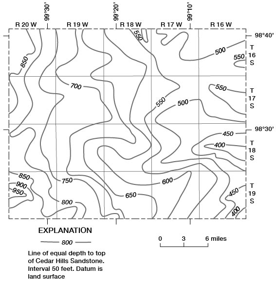
The Flower-pot Shale, Blaine Formation, and Dog Creek Formation, which are difficult to identify in the subsurface, were not differentiated in this study. The part of the Nippewalla Group above the Cedar Hills Sandstone is about 100 feet thick, but may be considerably thicker locally; it is relatively impermeable and retards movement of highly mineralized water from the Cedar Hills Sandstone to the overlying Cretaceous rocks.
Water supply--Sandstone beds in the Nippewalla probably contain water. No data were obtained on the quantity or quality of water available from the Nippewalla in the county. Water from Permian rocks, probably the Nippewalla, was collected from six test holes in Russell County by Swineford and Williams (1945). The concentration of dissolved solids in the samples ranged from 31,000 to 71,000 mg/l (milligrams per liter).
Cretaceous System--Lower Cretaceous Series
Cheyenne Sandstone
The Cheyenne Sandstone was named by Cragin (1889, p. 65) from Cheyenne Rock in sec. 8, T. 30 S., R. 16 W., which is a prominent ledge of sandstone on the north side of Medicine Lodge River valley about three-fourths of a mile west of Belvidere in southeast Kiowa County.
Lithology, distribution, and thickness--The Cheyenne at the outcrop comprises chiefly light-colored friable cross-bedded fine- to medium-grained sandstone associated with lenses of sandy shale and conglomerate (Latta, 1946, p. 235). Swineford and Williams (1945) described the Cheyenne in the subsurface in Russell County as predominantly buff to light-gray sandstone containing small amounts of shale and siltstone. In the subsurface of Cheyenne County, Merriam and others (1959) describe the Cheyenne Sandstone as light-gray or brown fine- to medium-grained sandstone with some medium- to dark-gray noncalcareous shale. Exposures of Cheyenne Sandstone are confined to Barber, Kiowa, and Comanche Counties in south-central Kansas (Latta, 1946, p. 238), but the unit may be found in the subsurface in most of western Kansas.
The erosional surface on which the Cheyenne was deposited caused considerable range in thickness of the formation. In the type area the thickness of the Cheyenne ranges from 32.5 to 94 feet (Latta, 1946, p. 238), and in the subsurface the maximum thickness is 300 feet (Moore and others, 1951). In Rush County the thickness is estimated to range from 25 to 100 feet.
Water supply--The Cheyenne is considered to be an aquifer, but is not known to have been tapped for water supplies in Rush County. To the northeast in Russell County, Swineford and Williams (1945) collected six samples of water from the Cheyenne that contained from 33,000 to 62,000 mg/l dissolved solids.
Kiowa Formation
The Kiowa Formation, which overlies the Cheyenne, was named by Cragin (1894, p. 49) from exposure in Kiowa County, Kans.
Lithology, distribution, and thickness--The Kiowa Formation in the type area was described by Latta (1946) as consisting primarily of dark-gray to black thinly laminated shale grading upward into gray, tan, and brown clay and clay shale, but containing sandstone lenses throughout and thin beds of shell limestone in the lower part. In the subsurface in Russell County, the Kiowa consists of gray to black thinly laminated shale and interbedded thin white sandstone and siltstone (Swineford and Williams, 1945). In the subsurface in Cheyenne County the formation consists of medium- to dark-gray shale, some gray sandstone and siltstone, and a thin bed of impure limestone (Merriam and others, 1959). The Kiowa is exposed over a wide area in central Kansas (Plummer and Romary, 1942) and is in the subsurface in the western half of the state. Latta (1946) reports a maximum thickness of 293 feet of Kiowa in a test hole in the type area. Plummer and Romary (1942) report 100 to 125 feet over much of central Kansas; the range in thickness is assumed to be the same for Rush County.
Water supply--The Kiowa is considered to be an aquifer but no wells are known to produce water from the formation in Rush County. Eight water samples from the Kiowa in Russell County contained from 33,000 to 59,000 mg/l dissolved solids (Swineford and Williams, 1945).
Cretaceous System--Lower and Upper(?) Cretaceous Series
Dakota Formation
Meek and Hayden (1862) applied the name "Dakota Group" to the sandstone, various colored clay, and lignite beds that underline the "Benton Group" in eastern Nebraska. The name "Dakota Formation," as applied by the State Geological Survey of Kansas, is used in the sense described by Plummer and Romary (1942) and includes the continental and littoral beds occurring above the Kiowa Formation and below the Graneros Shale. The Dakota was subdivided by Plummer and Romary (1942) into the Terra Cotta Clay Member at the bottom and the Janssen Clay Member at the top.
The State Geological Survey of Kansas classifies the Dakota Formation in the Lower and Upper(?) Cretaceous Series; O'Connor (1968, p. 56) states that the boundary between Lower and Upper Cretaceous rocks "properly should be placed within the Dakota Formation".
Lithology, distribution, and thickness--The following description of the lithology of the Dakota is taken from the description by Plummer and Romary (1947). The Terra Cotta Clay Member, which includes massive clay, silt, and sandstone, composes approximately the lower two-thirds of Dakota Formation. The Janssen Member includes beds of lignite, gray to dark-gray massive clay, silt, and some shale. Prominent sandstone layers and lenses are numerous but about three-fourths of the formation is clay, which is quantitatively the most important type of sedimentary material. The clay is dominantly kaolinite.
The Dakota crops out in Kansas from Washington County on the north, southwest to Kiowa County on the south, and in small patches in the southwest part of the State. Except in extreme south and southwest Kansas, it is found in the subsurface west of the outcrop. The Dakota does not crop out in Rush County. In the deep valleys of Walnut Creek and its tributaries in the east half of the county, and the Smoky Hill River and its tributaries in the northeast part of the county, the bedrock underlying the valley-fill deposits is Dakota. Study of electric and radioactive logs did not permit adequate delineation of the top or bottom of the Dakota in Rush County, and test-hole information is sparse. The thickness of Dakota ranges from 100 to 300 feet (Moore and others, 1951), although Merriam and others (1959) report 350 feet in the subsurface in Cheyenne County. In Rush County the thickness is estimated to range from 200 to 300 feet.
Water supply--The Dakota is a principal aquifer, and dependable water supplies generally are available to wells throughout Rush County. Well yields range from a few gallons per minute for domestic supplies to a reported 500 gpm (gallons per minute) from a municipal well at La Crosse. Water from the Dakota is used extensively in the county except in Walnut Creek and Smoky Hill River valleys and their major tributaries. Reports from well drillers and land owners indicate that the depth to sandstone lenses in the Dakota is unpredictable. The quality of water in the Dakota is variable and generally is considered to be marginal for domestic use and irrigation. The dissolved-solids concentration ranged from 309 to 3,660 mg/l for 30 samples analyzed.
Cretaceous System--Upper Cretaceous Series
Graneros Shale
The Graneros Shale was named by Gilbert (1896) from exposures at Graneros and on Graneros Creek in Pueblo County, Colo. The formation overlies the Dakota and is unconformably overlain by the Greenhorn Limestone in central Kansas (Hattin, 1965).
Lithology, distribution, and thickness--The Graneros is composed primarily of gray to black noncalcareous to slightly calcareous silty shale; it contains some sandstone lenses and bentonite. One bentonite layer is an easily identifiable marker bed on electric logs in the western third of Kansas (Merriam, 1957).
Surface exposures of Graneros generally are poor, but it is exposed from Ford County on the southwest to Washington County on the northeast. The formation is in the subsurface west of the outcrop belt. No outcrop of Graneros was located in Rush County. The Graneros is present in the subsurface throughout the county, except beneath Walnut Creek and deep tributary valleys east of R. 19 W.
Reported thicknesses of the Graneros range from 14 feet in Russell County (Swineford and Williams, 1945) to about 100 feet in Cheyenne County (Merriam and others, 1959). Hattin (1965) reports a range in thickness of the Graneros from 23.6 to 40.4 feet in central Kansas; this range in thickness is assumed to apply to Rush County where the Graneros is present.
Water supply--The Graneros is not known to yield water to wells in Rush County.
Greenhorn Limestone
The Greenhorn Limestone was named by Gilbert (1896) from exposures at Greenhorn Station and on Greenhorn Creek, south of Pueblo, Colo. Four members of the Greenhorn are recognized by the State Geological Survey of Kansas. In ascending order they are: Lincoln Limestone Member, Hartland Shale Member, Jetmore Chalk Member, and Pfeifer Shale Member. Rubey and Bass (1925) named the Lincoln and Jetmore, and Bass (1926) named the Hartland and Pfeifer. The Greenhorn lies unconformably on Graneros Shale and conformably underlies Carlile Shale.
Lithology, distribution, and thickness--The Greenhorn comprises a sequence of alternating chalky limestone and chalky shale; it contains thin crystalline limestone beds in the basal member. The outcrop of the formation extends from Ford County on the south to Washington County on the north, with less extensive exposures in Hamilton and Kearny Counties in the southwest. In the subsurface the Greenhorn is found west and north of the outcrop and into adjacent states. Thickness of the formation ranges from 65 feet in Jewell County to 132 feet in Hamilton County. The thickness averages 100 feet in Rush County.
The Greenhorn Limestone is the oldest and most prominent rock unit that crops out in Rush County. The Greenhorn is not subdivided on plate 1.
Exposures of the Lincoln Limestone Member were not noted during field work, but some may be present in the northeastern part of the county. The Hartland Shale Member is exposed in stream banks, particularly in the northeastern part of the county.
The Jetmore Chalk Member is the most resistant member of the Greenhorn and the "shell" or "shellrock" bed at the top is diagnostic. The "shellrock" averages about 1 foot in thickness, may be unevenly bedded and appear to have a concretionary upper surface, and is composed chiefly of fossil clam shells. The top bed of the Jetmore has been quarried in the county.
The top bed of the Pfeifer Shale Member, the Fence-post limestone bed, has been extensively quarried. Other limestone beds in the Greenhorn and also in the lower part of the Carlile Shale occasionally have been quarried; thus, reliance on quarries alone to map the top of the Greenhorn is not recommended. Perhaps the best marker for mapping the top of the Greenhorn is the "sugar sand" (Moss, 1932). The "sugar sand" is about 6 feet below the top of the Fence-post Limestone, and about 15 feet above the "shellrock" or top of the Jetmore. White calcite prisms are found at the base of the "sugar sand," which is composed primarily of granular calcite with a silty clay binder. It is crumbly, averages 4 inches in thickness, and resembles white sugar when fresh and brown sugar when weathered. A similar sand about 2 inches thick associated with 2 inches of bentonite, which underlies a 6-inch limestone in the basal Carlile Shale, occurs about 5 feet above the top of the Fence-post bed. The occurrence of these insignificant-appearing sands are quite useful for locating the Greenhorn-Carlile contact.
Water supply--The Greenhorn Limestone is not considered to be an aquifer in Rush County and no wells were inventoried that obtained water from the formation. Several dug wells in the county terminate in the Greenhorn but the water in the wells comes from overlying colluvial and fluvial material.
Carlile Shale
The Carlile Shale was named by Gilbert (1896) from exposures of gray shale near Carlile Station west of Pueblo, Colo., along the Arkansas River. Three members of the Carlile are recognized by the State Geological Survey of Kansas. In ascending order they are: the Fairport Chalk Member (Rubey and Bass, 1925), Blue Hill Shale Member (Logan, 1897), and Codell Sandstone Member (Bass, 1926).
Lithology, distribution, and thickness--The lower 25 feet of Fairport is similar to the underlying Greenhorn and contains primarily chalky limestone beds and chalky limestone concretion zones intercalated with chalky shale. The rest of the Fairport contains chalky shale and some chalky limestone. Bentonite beds in the Fairport are usable markers and are persistent over much of the outcrop area (Hattin, 1962). The Fairport is distributed on the surface from Washington County in the northeast to Finney and Hamilton Counties in the southwest, and in the subsurface west of the outcrop. Thickness of the Fairport ranges from 90 feet along the Saline River in north Ellis County to 120 feet in Finney and Hodgeman Counties (Hattin, 1962).
Outcrops of the Fairport in Rush County, with a few exceptions, are confined to the lower 25 to 30 feet of the member. The exceptions are middle to upper Fairport, which is exposed along Big Timber Creek and along some of the other tributaries of the Smoky Hill River in northwestern Rush County.
The Blue Hill Shale Member is a dark-bluish-gray slightly silty, clayey shale. The member contains numerous large concretions. Hattin (1962, p. 64) states: "Three kinds occur: Calcareous septarian concretions (most abundant), non-calcareous clay-ironstone concretions, and sandstone concretions (least common)." Many of the concretions are found in traceable, widespread zones, but great numbers have no zonal distribution. The distribution of the Blue Hill in Kansas is similar to the Fairport, but offset to the west. Thickness of the member ranges from 72 feet in Hamilton County to 215 feet in Jewell County.
The Blue Hill probably is absent east of R. 19 W. in Rush County because of erosion. It crops out in the northwest and southwest corners of the county. Examples of concretions or their remnants may be found in the SE sec. 19, T. 16 S., R. 20 W., and the SW sec. 20, T. 16 S., R. 20 W.
The Codell Sandstone Member is chiefly fine to very fine grained silty sandstone. It is distributed over the State in a manner similar to the rest of the Carlile, but farther west than the lower members. Thickness of the member ranges from half a foot in Jewell County to 31 feet in Ellis County (Hattin, 1962).
The Codell crops out in the SW sec. 6, T. 16 S., R. 20 W., in Rush County and comprises 4 feet of rusty-orange friable silty sand; it overlies 2 feet of the Blue Hill Shale Member, and is overlain by about 5 feet of the Fort Hays Limestone Member of the Niobrara Chalk. No other Codell was noted in the county.
In Rush County, the maximum thickness of the Carlile Shale is estimated to be 300 feet.
Water supply--No water supplies are known to be obtained from the Carlile in Rush County. In some circumstances the Carlile may serve as the container in a dug well but the water comes from overlying colluvial and fluvial material. The Carlile is not considered to be an aquifer in Rush County.
Niobrara Chalk
The Niobrara Chalk was named by Meek and Hayden (1862) from exposures in bluffs along the Missouri River in northern Nebraska. Two members of the Niobrara are recognized by the State Geological Survey of Kansas--the Smoky Hill Chalk Member above and the Fort Hays Limestone Member below. The Smoky Hill is not present in Rush County and only about 10 feet of the basal Fort Hays Member is present in the northwest corner of the county. The Niobrara Chalk is not an aquifer in Rush County.
Tertiary System--Pliocene Series
Ogallala Formation
The Ogallala Formation was named by Darton (1899) from exposures that he later (Darton, 1920) designated as being near Ogallala Station in western Nebraska. Three members of the Ogallala are recognized by the State Geological Survey of Kansas: the Valentine Member at the base, the Ash Hollow Member in the middle, and the Kimball Member at the top (Zeller, 1968). A detailed discussion of the Ogallala is contained in Bulletin 118 of the State Geological Survey of Kansas (Frye, Leonard, and Swineford, 1956). The Ogallala was mapped as a single unit for this report, but in the following discussion the members are designated when applicable.
Lithology, distribution, and thickness--The dominant types of lithology of the Ogallala in Rush County are (1) arkosic sand and gravel with associated clay balls that are sometimes poorly cemented with calcium carbonate, clay and silt beds, and some bentonite, (2) a quartzitic-appearing green conglomerate with an opaline cement matrix, and (3) a distinctive, discontinuous, very hard and dense white to pink limestone commonly referred to as "algal limestone." A study by Swineford, Leonard, and Frye (1958) indicates that development of the limestone was by soil-forming processes rather than by algae, and that pisolitic limestone is an accurate descriptive term for the bed. Common conversational usage is "algal limestone," which is used in this report. The "algal limestone" marks the stratigraphic top of the Ogallala Formation and the Kimball Member.
The Ogallala lies unconformably on Greenhorn, Carlile, and Niobrara in Rush County. Its areal distribution, shown on plate 1, generally is confined to the divide areas between Walnut Creek and the Smoky Hill River drainage in the north, and between Walnut Creek and the Pawnee River drainage in the south.
Frye, Leonard, and Swineford (1956, p. 73) describe the following measured section in the SW sec. 1, T. 16 S., R. 21 W., Ness County:
| Thickness, feet |
||||
|---|---|---|---|---|
| Ogallala Formation | ||||
| Ash Hollow Member | ||||
| 6. | Silt, densely cemented, pale-gray to pinkish-gray; contains irregular opalized nodules | 3 | ||
| 5. | Sand and silt, loosely cemented, pinkish-tan, partly covered. At this stratigraphic position in the NW SW sec. 21, T. 15 S., R. 21 W., Trego County, the following fossil seeds were collected: Berrichloa conica, B. tuberculata, Biorbia fossilia, Celtis willistoni | 2.5 | ||
| 4. | Sand, fine to coarse, some pebbles, cemented; weathers to smooth convex surfaces | 7.5 | ||
| 3. | Covered | 7 | ||
| Valentine Member (?) | ||||
| 2. | Conglomerate, densely cemented with opal; the opaline matrix has distinct green color and and is lenticular in distribution | 10 | ||
| 1. | Gravel and cobbles of Cretaceous Niobrara Chalk to 1 foot in diameter, in matrix of clay and chalk sand. Base rests on Niobrara Chalk | 3 | ||
| Total Ogallala measured | 33 | |||
The Ogallala exposed in the northwestern part of Rush County (SW sec. 6, and NW sec. 7, T. 16 S., R. 20 S.) resembles bed 2, and is locally referred to as "green granite." Except for bed 2, the Ogallala north of Walnut Creek probably represents the Ash Hollow Member. About 20 feet of crossbedded, slightly consolidated arkosic sand and gravel, which rests on upper beds of the Fairport Chalk Member of the Carlile Shale in a gravel pit in the SE sec. 16, T. 17 S., R. 19 W., is the most extensive exposure of Ash Hollow north of Walnut Creek. Test hole 17-19W-21aaa in the northeast corner of section 21 in the same township penetrated 28.0 feet of Ogallala. Another exposure of Ogallala in the north half of the county is in a trench silo in the NW sec. 12, T. 17 S., R. 18 W., where about 6 to 8 feet of sand, gravel, and silt rests on the Fairport.
Test-hole logs and samples, shot-hole logs, gravel pits, and natural exposures document the occurrence of considerable Ogallala, predominantly Ash Hollow but with some Kimball, south of Walnut Creek. Gravel pits in the SW sec. 8, T. 19 S., R. 20 W.; the SE sec. 28, T. 19 S., R. 19 W.; and the SE sec. 26 and the SW sec. 25, T. 19 S., R. 18 W., contain slightly consolidated very fine to medium-grained crossbedded sand and some gravel of arkosic composition with associated balls of clay, and some local gravel composed of Cretaceous limestone fragments. The thickest Ogallala found in the county was about 44 feet in test hole 19-18W-33aba. The Kimball is recognized in numerous places south of Walnut Creek on the basis of "algal limestone" that caps topographic highs, including distinctive conical knolls. "Algal limestone" is exposed in the trail between the SE sec. 36, T. 18 S., R. 16 W., and the NE sec. 1, T. 19 S., R. 16 W.; in the south road ditch in the NE NW sec. 16, T. 19 S., R. 16 W.; on top of the hill in the NW sec. 25, T. 19 S., R. 18 W.; on top of the hill in the SE sec. 28, T. 19 S., R. 18 W.; toward the top of two trench silos on the north side of SE the road in the SE SW sec. 29, T. 19 S., R. 19 W.; on a small ridge south of the road in the NW sec. 17, T. 19 S., R. 20 W.; along the road in the NW sec. 26, T. 19 S., R. 20 W.; and in numerous other places in the south tier of townships. The lithology and thickness of the Ogallala are shown by logs at the end of this report.
Water supply--The Ogallala is not an aquifer in Rush County because it is drained by streams that have eroded headward toward the divide areas. The drainage precludes water storage except in the most temporary sense. None of the wells inventoried obtained water from the Ogallala.
Quaternary System--Pleistocene Series
The Pleistocene Series has been divided into four glacial stages (Nebraskan, Kansan, Illinoisan, Wisconsinan) and four interglacial stages (Aftonian, Yarmouthian, Sanagmonian, Recent) by the State Geological Survey of Kansas (Bayne and O'Connor, 1968). Most of these stages are thought to be represented in Rush County. Topographic position, fauna, and lithology of deposits in relation to adjoining or very similar deposits in adjacent counties form the basis for this belief. Three categories of Pleistocene deposits were mapped in the county (pl. 1). Two of the three mapped units are unconsolidated, principally fluvial, deposits conveniently separated by their relative topographic position. The deposits in terrace position, herein called terrace deposits, and the deposits in valleys, herein called valley-fill deposits, may be of Kansan, Illinoisan, Wisconsinan, or Recent age. The third mapped unit is primarily an unconsolidated eolian deposit but contains some fluvial and colluvial material. These deposits, herein called undifferentiated deposits, may be as old as Nebraskan but commonly are Wisconsinan and Recent in age.
Terrace Deposits
Lithology, distribution, and thickness--Fluvial deposits with some eolian and colluvial components are found in terrace position along the valleys of the major streams and their tributaries. These deposits of clay, silt, sand, and gravel primarily are arkosic, but often include some limestone pebbles. Thickness of the deposits may be as much as 70 feet bordering Walnut Creek valley, 50 feet bordering Big Timber Creek valley, and 40 feet bordering Dry Walnut Creek valley.
Water supply--The terrace deposits yield small to moderate supplies of water to wells. Two irrigation wells in Walnut Creek valley and one in Dry Walnut Creek valley obtain all or part of their water from these deposits; yields range from 290 to a reported 400 gpm. Numerous stock and domestic wells also obtain their water from these deposits. Water from the terrace deposits is hard, but otherwise is of satisfactory chemical quality for the uses mentioned.
Valley-fill Deposits
Lithology, distribution, and thickness--Fluvial clay, silt, sand, and gravel compose the valley-fill deposits. The upper 20 to 40 feet of the fill is predominantly silt with some clay that overlies a thick deposit of sand and gravel in Walnut Creek valley. In Dry Walnut Creek valley, the fill is principally silt with minor amounts of sand and gravel. The fill in Big Timber Creek valley is not as thick as the fill in Walnut Creek valley, but the lithology is similar. Thickness of the fill may be as much as 120 feet in Walnut Creek valley, slightly more than 100 feet in Dry Walnut Creek valley, and more than 40 feet in Big Timber Creek valley. The valley fill is as much as 2 miles wide in Walnut Creek valley and three-fourths of a mile wide in Dry Walnut and Big Timber Creek valleys.
About 30 different forms of snails and several forms of clams were noted in the samples from test holes drilled across Walnut Creek valley. Samples from test hole 18-17W-31bbc were particularly abundant in number of shells and in number of forms. The precise depths from which the different shells came are not known, but, between 30 and 75 feet, shells were so numerous as to appear to be the major part of the return from the drilling operation.
The drill cuttings containing the shells were blue to gray silty clay, fine to coarse arkosic sand, and medium to coarse, predominantly limestone, gravel. Although the volume of material returned in the 30- to 75-foot interval was normal, only 10 small sacks of sample material were collected. Each sack of the material was then split into one small sample-cuttings envelope in the office. In light of the sampling procedure just described, the number of shells and forms recovered is remarkable.
The following fossil mollusks were recovered from the sample cuttings from test hole 18-17W-31bbc, Rush County, Kans. The shells were identified by the author.
| Number of Specimens |
||
|---|---|---|
| Fresh-water Snails | ||
| Amnicola limosa parva Lea | 44 | |
| Ferissia parallela (Haldeman) | 3 | |
| Gyraulus labiatus Leonard | 112 | |
| Helisoma antrosa (Conrad) | 7 | |
| Lymnaea SP | 6 | |
| Menetus pearlettei Leonard | 2 | |
| Pomatiopsis cincinnatiensis (Lea) | 2 | |
| Valvata tricarinata (Say) | 177 | |
| Land Snails | ||
| Carychium perexiguum Baker | 6 | |
| Gastrocopta proarmifera Leonard | 5 | |
| Gastrocopta procera (Gould) | 1 | |
| Gastrocopta tappaniana (C.B. Adams) | 2 | |
| Helicodiscus parallelus (Say) | 2 | |
| Pupilla muscorum sinistra Franzen | 1 | |
| Pupoides albilabris (C. B. Adams) | 2 | |
| Retinella electrina (Gould) | 12 | |
| Succinea SP | 17 | |
| Vallonia gracilicosta Reinhardt | 72 | |
| Vertigo millium (Gould) | 4 | |
| Vertigo ovata Say | 2 | |
| Zonitoides arboreus (Say) | 3 | |
| At least two forms of clams | ||
The fauna indicates that the summers were not as hot as they are in Rush County at the present time, but winters may not have been cooler. Precipitation probably was greater and a generally more humid condition prevailed. Permanent bodies of cool water are indicated. In terms of age, the list above appears to fit well in the assemblage of fossils of Kansan age described by Leonard (1950) and Frye and Leonard (1952).
Water supply--Yields ranging from 400 to 1,200 gpm are obtained from the valley-fill deposits by irrigation wells in Walnut Creek valley, and yields as large as 1,500 gpm have been reported. No irrigation wells obtain water from these deposits in Big Timber and Dry Walnut Creek valleys; however, small to moderate supplies are obtained by stock and domestic wells. The water is hard but suitable for most uses. The dissolved-solids concentration for 17 water samples analyzed ranged from 369 to 789 mg/l.
Undifferentiated Deposits
Lithology, distribution, and thickness--Eolian deposits, with some fluvial and colluvial components that are predominantly silt containing some sand and some gravel, compose the undifferentiated deposits. The silt probably is loess of Wisconsinan age; it commonly overlies sand and some gravel. In the northwestern part of the county, the lower part of the undifferentiated deposits may be of Nebraskan age because of their topographic position and relation to similar deposits in Ellis County. The greatest thickness of these deposits, as much as 56 feet, was found in Tps. 17 and 18 S., R. 20 W. Other areas with thick undifferentiated deposits are in T. 16 S., R. 20 W., and T. 17 S., R. 16 W. These thick deposits definitely are fluvial in origin, except for the overlying loess, and may represent buried channels of Nebraskan age.
Water supply--Small to moderate yields are obtained from these deposits by some stock and domestic wells in the county where the deposits are relatively thick. However, such a favorable circumstance is not widespread. The water is very hard, but otherwise is satisfactory for stock and domestic uses.
Prev Page--Geology || Next Page--Ground Water
Kansas Geological Survey, Geology
Placed on web Aug. 22, 2008; originally published July 1973.
Comments to webadmin@kgs.ku.edu
The URL for this page is http://www.kgs.ku.edu/General/Geology/Rush/04_rock.html