![]()
Prev Page--Introduction || Next Page--Rock Units
General Geology
Note: The classification and nomenclature of rock units used in this report are those of the State Geological Survey of Kansas and differ somewhat from those used by the U.S. Geological Survey.
Distribution of Subsurface Rocks
Precambrian Rocks
Rocks of Precambrian age do not crop out in Kansas. Precambrian rocks in the State have been studied using well samples, logs, and geophysical methods (Farquhar, 1957). The recorded number of wells penetrating Precambrian rocks in Rush County through 1964 totals 224 (Cole and others, 1961, 1965). The predominant types of Precambrian rocks reported from about 70 percent of the wells were granite or granite wash. Other Precambrian rock types include quartzite, quartz, porphyry, gneiss, schist, and diabase. A map of the configuration of the top of Precambrian rocks in Kansas by Cole (1962) shows an upthrown block of Precambrian rocks (fig. 5) trending southeastward from southwest Ellis County, across Rush County, to southwest Barton County. The depth to the top of the fault block ranges from 3,500 to 3,800 feet below land surface in Rush County.
Figure 5--Trend of faulted block of Precambrian rocks (from Cole, 1962).
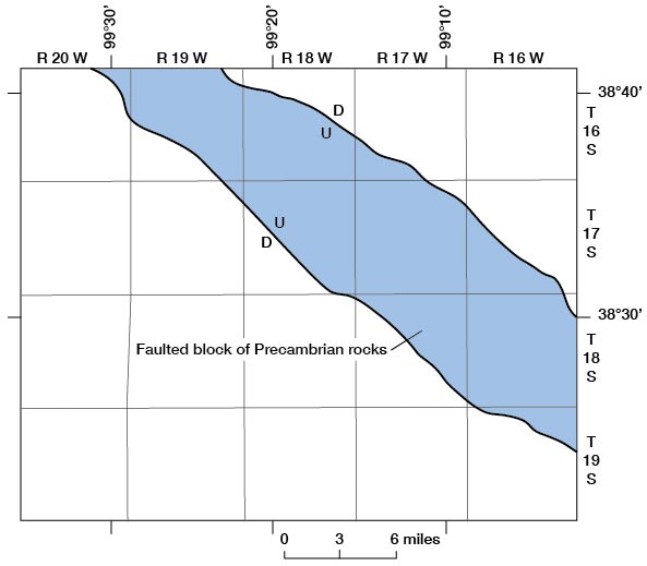
Of probable interest are potassium-argon determinations made by J. Lawrence Kulp of Lamont Geological Observatory at Columbia University (Cole and Merriam, 1962) of the age of Precambrian rock samples from two wells in the county. Granite gneiss from the Skelly No. 1 Betz well in the NE SE SW 14 sec. 5, T. 18 S., R. 16 W., was dated at 1,260 million years and gray quartzite from the Skelly No. 4 Dyer in the NE SE NW sec. 21, T. 18 S., R. 16 W., was dated at 1,200 million years.
Paleozoic Rocks
Rocks of Paleozoic age do not crop out in Rush County. They have been studied using geophysical methods and well samples. The following maps issued by the State Geological Survey of Kansas reveal the general distribution and regional structure of Paleozoic rocks in Kansas: Arbuckle (Cambrian-Ordovician) rocks (Merriam and Smith, 1961), Silurian and Devonian rocks (Merriam and Kelly, 1960), Mississippian rocks (Merriam, 1960), and the Lansing Group of Pennsylvanian age (Merriam, Winchell, and Atkinson, 1958).
Briefly, distribution of Paleozoic rocks in Rush County is: Cambrian rocks are locally absent over the previously discussed upthrown Precambrian fault block (fig. 5) but are present beneath the rest of the county; Ordovician rocks are absent along the same general trend as the upthrown Precambrian fault block but are present elsewhere in the county; Silurian and Devonian rocks are absent throughout the county; Mississippian rocks are present in the southwest part of the county and absent elsewhere; Pennsylvanian and Permian rocks underlie the entire county.
Mesozoic Rocks
Rocks of Mesozoic age in Rush County belong to the Cretaceous System. Cretaceous rocks unconformably overlie Paleozoic rocks and, in much of the county, are overlain unconformably by Cenozoic rocks. The Cretaceous units that underline the county but do not crop out include, in ascending order: Cheyenne Sandstone, Kiowa Formation, Dakota Formation, and Graneros Shale. These units are discussed in the section on geology and water supply.
Distribution of Exposed Rocks
Rock units exposed at the land surface, as shown on the geohydrologic map of Rush County (pl. 1), are sedimentary and range in age from Cretaceous to Pleistocene. Geologic relationships and the position of the water table are shown in selected geologic sections on figure 6.
Figure 6--Geologic sections. A larger version of this figure is available.
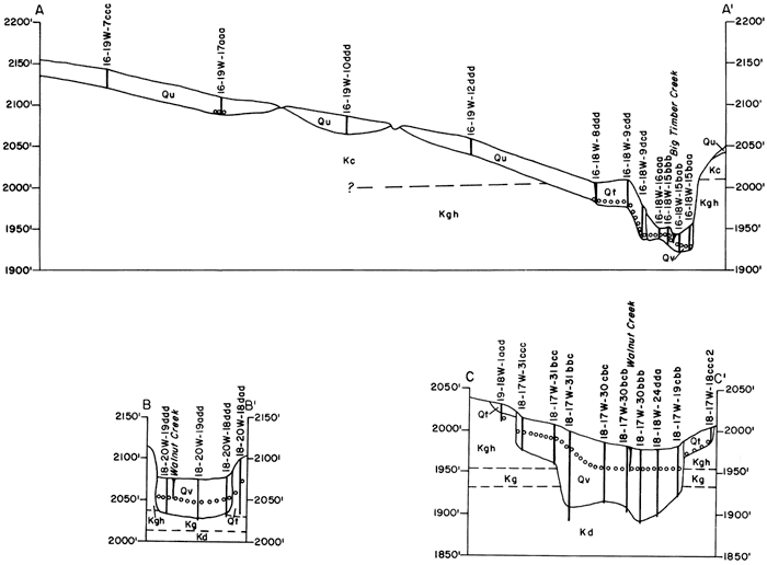
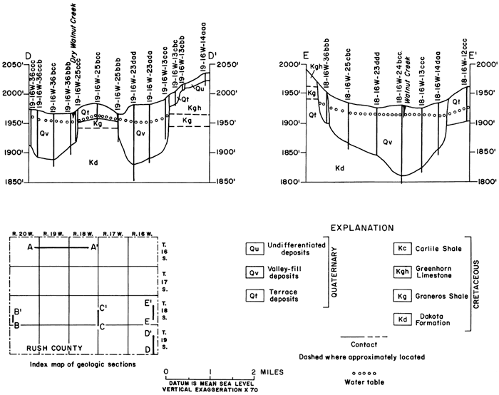
The oldest rocks exposed in Rush County are marine deposits of Late Cretaceous age. The Greenhorn Limestone is the prominent rock cropping out along most stream valleys in all but the northwest quarter and the southwest eighth of the county. The Greenhorn underlies all but the deep valleys of Walnut Creek, the Smoky Hill River, and tributaries to Walnut Creek and the Smoky Hill River. The Graneros Shale or Dakota Formation underlies these valleys. Conformably overlying the Greenhorn is the Carlile Shale (Hattin, 1962, p. 24). The lower 20 to 35 feet of Carlile is relatively resistant; it crops out in stream valleys and closely resembles Greenhorn. The Carlile Shale is the bedrock formation in much of the upland area of the county. Above and unconformably overlying the Carlile Shale is the Fort Hays Limestone Member of the Niobrara Chalk (Hattin, 1962, p. 91), which is exposed in the extreme northwest corner of the county.
Fluvial deposits of the Ogallala Formation of Pliocene age occur as erosional remnants unconformably overlying Greenhorn Limestone, Carlile Shale, and Fort Hays Limestone Member on the highest upland areas. Clay, silt, sand, and gravel of Pleistocene age unconformably overlie Cretaceous and Pliocene rocks in most of the county. Fluvial deposits are present on divide areas and in stream valleys. Most upland surfaces are thinly mantled with eolian silt or loess. Slope deposits or fluvial and colluvial deposits are present in headland areas of streams and on slopes along stream courses.
Prev Page--Introduction || Next Page--Rock Units
Kansas Geological Survey, Geology
Placed on web Aug. 22, 2008; originally published July 1973.
Comments to webadmin@kgs.ku.edu
The URL for this page is http://www.kgs.ku.edu/General/Geology/Rush/03_geol.html