![]()
Prev Page--Geography || Next Page--Ground Water
Geology
[Note: The classification and nomenclature of the rock units used in this report are those of the State Geological Survey of Kansas and differ somewhat from those of the U.S. Geological Survey.]
The areal distribution of the gelogic units exposed in Pratt County is shown on plate 1. Descriptions of the rocks and their water-bearing properties are given in table 2. The stratigraphic position of the units is shown by the geologic sections on plate 2.
Table 2--Generalized section of geologic formations and their water-bearing properties.
| System | Series | Stage | Stratigraphic unit |
Maximum thickness (feet) |
Physical characteristics | Water Supply2 |
|---|---|---|---|---|---|---|
| Quaternary | Pleistocene | Recent and Wisconsinan |
Alluvium and terrace deposits |
60 | Stream deposits of silt, sand, and gravel in and near channels of major streams; small areal extent. | Yields small to medium supplies of water to wells along major streams. |
| Dune sand |
50 | Very fine to medium sand in upland areas; well-sorted. | Generally lies above potentiometric surface. Yields small supplies of water to wells in northwestern part of county. | |||
| Sangamonian | Sangamon Soil |
60 | Eolian silt and fluvial silt and clay; thin basal sand and gravel (Crete Formation) | Generally lies above potentiometric surface, but yields small to medium supplies of water to wells in northwestern part of county and in areas where ground water is perched. | ||
| Illinoisan | Loveland and Crete Formations |
|||||
| Yarmouthian | Yarmouth Soil |
200 | Silt, sand, and gravel. Locally contains clay lenses and a volcanic ash lens. Calcareous zones commonly near top and center; gravel more abundant toward base. | Yields large supplies of water to wells. Major aquifer in the county. | ||
| Kansan | Sappa1 and Grand Island Formations |
|||||
| Aftonian | Afton Soil | 85 | Silt, sand, and gravel; clay and calcareous zones common. | Yields medium supplies of water to wells. Water highly mineralized in Cairo area. | ||
| Nebraskan | Fullerton and Holdrege Formations |
|||||
| Unconformity | ||||||
| Cretaceous | Lower | Kiowa Formation |
60 | Gray to black silty shale with thin lenses of well-sorted white quartzose sandstone. | Yields no water to wells; forms base of ground-water reservoir in northwest part of county. | |
| Unconformity | ||||||
| Permian | Upper | Whitehorse Formation |
270 | Red beds of shale, siltstone, sandstone, dolomite, anhydrite, and salt. | Yields no water to wells; forms base of ground-water reservoir under most of county. | |
| Lower | Nippewalla Group |
1,000 | ||||
| 1 Locally contains the Pearlette ash bed. 2 In this report, small supplies refers to yields generally less than 100 gpm, medium supplies to 100 to 1,000 gpm, and large supplies to greater than 1,000 gpm. |
||||||
Summary of Stratigraphy
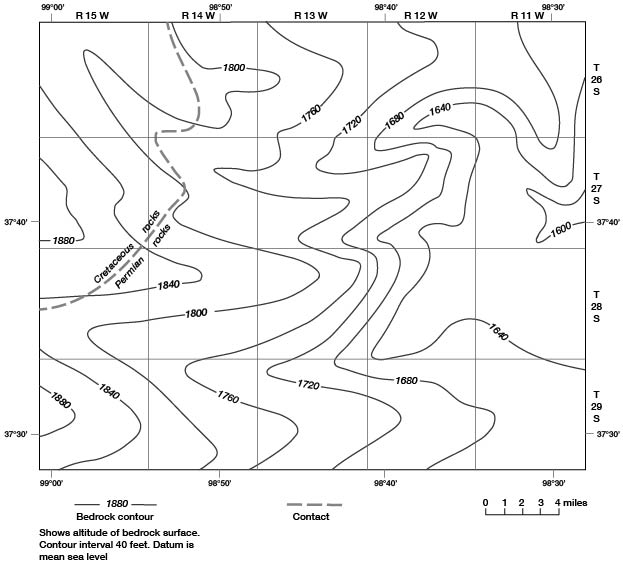
The rocks pertinent to the hydrology of Pratt County range in age from Permian to Recent. All the geologic units that yield water suitable for the common uses lie above the red beds of the Nippewalla Group and Whitehorse Formation. In the northwestern part of the county the red beds are overlain by the Kiowa Formation of Cretaceous age. Together, the Permian and Cretaceous rocks form the bottom of the fresh ground-water reservoir in Pratt County. The configuration of this bedrock surface is shown on figure 4.
Figure 4--Configuration and general geology of the bedrock surface.
The bedrock formations are overlain by unconsolidated fluvial and eolian deposits of Pleistocene age. The Holdrege and Fullerton Formations of Nebraskan age unconformably overlie the bedrock throughout most of Pratt County at depths ranging from 35 to 300 feet below land surface.
The Nebraskan fluvial deposits are overlain by the Grand Island and Sappa Formations of Kansan age, which are distributed throughout Pratt County. The Kansan rocks crop out in the valley of the South Fork Ninnescah River and along many of its tributaries. The rocks crop out and form rugged topography along tributaries of Medicine Lodge River. The Pearlette ash bed in the Sappa Formation commonly is used as a time-stratigraphic marker.
The Crete and Loveland Formations of Illinoisan a,,e, which include eolian (wind-deposited) as well as fluvial sediments, overlie the Kansan rocks throughout the upland area of Pratt County. The formations once blanketed the entire county but they have been removed, in part, by stream erosion.
The Illinoisan deposits are overlain discontinuously by dune sand of Wisconsinan and Recent are. The dune sand mantles most of northern Pratt County and the upland area in the southeastern part of the county. Alluvium and terrace deposits of Wisconsinan and Recent age occur in the channels and banks of the larger streams in the county.
Geologic Structure
The Pratt anticline is a post-Mississippian structure that is a southern extension of the Central Kansas uplift (fig. 5). The large, broad, southerly plunging anticline separates the Hugoton embayment from the Sedgwick basin (Merriam, 1963, p. 182). Merriam (1963, p. 252) has mapped eight northeasterly trending faults in Pratt County that are related to the Pratt anticline. Many of these faults exhibit vertical displacement (west side upthrown) in the Precambrian and lower Paleozoic rocks, but none of the faults reaches land surface.
Figure 5--Major post-Mississippian structural features in Kansas, and faults in Pratt County (after Merriam, 1963, pp. 178 and 252).
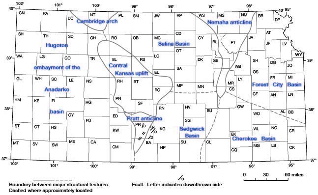
At 6:00 a.m. on January 6, 1956, an earthquake of moderate magnitude (intensity V on the modified Mercalli scale) occurred coincident with the Pratt anticline. The epicenter was in Barber County, near Coats, with the hypocenter at a depth of 20 miles. The earthquake was felt over an area of 18,500 square miles; it had an estimated duration of 9 seconds. For more detailed information the reader is referred to Dellwig (1956).
Geologic Units and Their Water-Bearing Properties
Permian Rocks
Nippewalla Group and Whitehorse Formation
Pratt County is underlain by red beds of Permian age that were deposited in shallow nearshore and low-lying continental environments. The rocks compose the Nippewalla Group and the Whitehorse Formation and consist of reddish-brown siltstone, shale, and sandstone with lesser amounts of salt, gypsum, anhydrite, limestone, and dolomite. The rocks are as much as 1,270 feet thick, but are not exposed in Pratt County; outcrops can be seen to the south and east in Barber and Kingman Counties. Depth to the formations below land surface ranges from 35 feet in the lower drainage area of Turkey Creek to about 300 feet in the uplands in southeastern Pratt County. The rocks are truncated by a major unconformity.
No wells are known to obtain water from the Nippewalla Group or the Whitehorse Formation in Pratt County. Water from wells in these Permian red beds probably would be too highly mineralized for any of the common uses.
Cretaceous Rocks
Kiowa Formation
Extensive marine deposits of Cretaceous are once underlaid Pratt County, but subsequent erosion his left only the Kiowa Formation in the northwestern part of the county (fig. 4; geologic section A-A, pl. 2). The formation unconformably overlies rocks of Permian age and consists of gray to black fossiliferous shale having well-sorted white quartzose sandstone lenses. From the erosional edge shown on figure 4, the formation thickens to more than 50 feet at the western margin of the county. Depth to the Kiowa Formation ranges from about 160 to about 250 feet below land surface. The Kiowa is not exposed in Pratt County, but the type location of the formation is to the west in neighboring Kiowa County.
In two test holes in the N2, T. 27 S., R. 15 W., drillers were unable to penetrate a hard sandstone beneath 25 to 50 feet of black shale. This indurated rock may be the Cheyenne Sandstone of Cretaceous age that crops out in southern Kiowa County.
The Kiowa Formation is not considered to be an aquifer in Pratt County. Although small quantities of water may be available to wells, the chemical quality of the water probably renders it unsuitable for any of the common uses.
Quaternary Rocks
The Pleistocene Series in Kansas is divided into four glacial stages (Nebraskan, Kansan, Illinoisan, Wisconsinan), and four interglacial stages (Aftonian, Yarmouthian, Sangamonian, Recent), as given in table 2. Deposits representing all the Pleistocene stages probably occur in the county, but not all can be differentiated clearly in test-hole samples. Logs of test holes 26-12W-34cdd and 28-13W-26dcb2, described in this report, show most distinctly the individual formations penetrated. The interrelationship of these formations is illustrated on the geologic sections on plate 2.
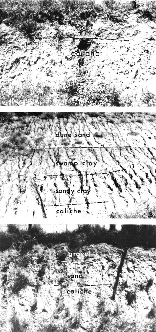
Each of the Pleistocene formations was deposited under similar conditions during successive glacial stages. The stages commonly began with a period of downcutting in the stream valleys followed by deposition of coarse sand and gravel. Lateral shifting of the streams resulted in blanket deposition of coarse material. As the glacial stage progressed and precipitation lessened, the ability of the streams to carry sediment decreased and progressively finer material was deposited. The fine-grained deposits of the late part of the glacial stage generally included eolian silt or sand. The interglacial stages were times during which neither erosional nor depositional processes were dominant and soils developed on the surface of the Pleistocene formations. Remnants of some of these soils are exposed in Pratt County (fig. 6).
Figure 6--A, Typical nodular caliche in clay of the Sangamon paleosol overlain by 1 foot of dune sand in the NE NE NE sec. 14, T. 29 S., R. 11 W. B, Sangamon nodular caliche and reddish-brown sandy clay overlain by a gray silty mud swamp deposit with a horizontal surface and Wisconsinan eolian deposits of tan silt and fine sand in an 18-foot road cut in the SW NW NW sec. 2, T. 28 S., R. 14 W. C, Gravel of the Crete Formation overlying leached orange-brown sand and granular caliche of the Yarmouth paleosol in the NE SE SE sec. 22, T. 27 S., R. 12 W.
Holdrege and Fullerton Formations
Nebraskan time in Pratt County is represented by deposits of sand, gravel, silt, and clay of the Holdrege and Fullerton Formations, which unconformably overlie rocks of Permian and Cretaceous age. These formations do not crop out in Pratt County, but they can be seen along the South Fork Ninnescah River to the east in Kingman County. The formations compose an almost continuous blanket that is more than 80 feet thick in places. The contact between the Holdrege and Fullerton Formations could not be recognized in some test holes. One test hole (26-11W-35ccc2) near the east end of geologic section A-A' (pl. 2) did not penetrate these formations above Permian rocks.
Character--The Holdrege Formation consists of sand and sandy gravel with silt and clay lenses. The gravel commonly contains pebbles of ironstone derived from Cretaceous rocks. The silt and clay lenses are pinkish-tan, tan, or light gray.
The Fullerton Formation generally is finer textured than the underlying Holdrege Formation, and consists of sand and silty sand with lenses of clay and silt. Nodular caliche near the top of the formation probably is the eroded remnant of Afton Soil. This paleosol (ancient soil) is found in many test holes, but nowhere was a complete soil profile found.
Water Supply--The Holdrege and Fullerton Formations compose an aquifer that is an important source of water in most of Pratt County. Wells drilled to bedrock generally penetrate 20 to 30 feet of sand and gravel that, with the average overlying aquifers, should yield 2,000 to 3,000 gpm (gallons per minute). However, very few of the existing irrigation wells tap this aquifer because sufficient quantities of water generally can be obtained from shallower formations.
The Holdrege and Fullerton Formations contain highly saline water near Cairo where the concentration of dissolved solids exceeds 10,000 mg/l (milligrams per liter). The areal extent of the highly saline water has not been determined in this study. Some details of the Cairo area are discussed in the quality of water section of this report.
Grand Island and Sappa Formations
The Kansan Stage of Pleistocene deposition is represented by the Grand Island and Sappa Formations, which are the oldest rocks exposed in Pratt County. The Grand Island Formation rests on the eroded surface of the Holdrege Formation, the Fullerton Formation, or the Afton Soil in most of the county. However, in the area of the bedrock high in T. 26 S., R. 11 W. (fig. 4), the Grand Island rests unconformably on eroded Permian red beds. The contact between the Grand Island and Sappa Formations is indistinct and is placed arbitrarily where the deposit changes from sand and gravel to overlying sand and silt.
The Kansan deposits are the thickest Pleistocene sediments in Pratt County; they form a continuous blanket that ranges in thickness from less than 30 to more than 196 feet. Minimal thicknesses are found at low altitudes in the river valleys. Outcrops of the formations, as illustrated on plate 1, form a dendritic pattern along the South Fork Ninnescah River eastward from Cullison and along tributaries of Medicine Lodge and Chikaskia Rivers in the southern part of the county. The formations were mapped as a single unit although the Sappa is absent in part of the area.
Character--The Grand Island Formation consists of fine to coarse sand and gravel with minor amounts of silt. Gravel is found throughout the formation but is most common near the base. A zone of gravel or sand that has been stained black by iron and manganese is common in this formation.
The following measured section, which includes 65 feet of Grand Island and Sappa Formations, was described in 1951 at an exposure along the South Fork Ninnescah River in sec. 4, T. 28 S., R. 12 W.
| Quaternary System | Thickness, in feet |
||||
|---|---|---|---|---|---|
| Pleistocene Series | |||||
| Crete and Loveland Formations | |||||
| 7. | Soil | 1.2 | |||
| 6. | Sand and medium to coarse gravel | 2.8 | |||
| Grand Island and Sappa Formations | |||||
| 5. | Silt, brown; contains some lime; grades to leached silt | 4.7 | |||
| 4. | Silt, sandy to compact, tan to brown; contains heavy lime accumulation | 13.9 | |||
| 3. | Sand, fine to very fine; contains lime nodules | 5.2 | |||
| 2. | Sand, medium, yellowish-brown | 10.4 | |||
| 1. | Sand and fine to coarse gravel, arkosic | 31.2 | |||
| Total measured | 69.4 | ||||
The Sappa Formation consists of sand and silt with lesser amounts of gravel and clay. Clay associated with caliche near the top of the formation represents remnants of the Yarmouth Soil. The white deposits of caliche (lime or calcium carbonate) are frequently, but mistakenly, called "gyp" or gypsum when seen on the surface or in drill cuttings. The clays and clayey silts generally are buff or tan, but other shades of brown and also gray were found in test-hole samples.
A lenticular bed of volcanic ash, called the Pearlette ash bed, is present near the top of the Sappa Formation. Details of the known locations and thicknesses of the isolated lenses of volcanic ash are described in the mineral resources section of this report. The Pearlette ash is recognized throughout a large area of the Great Plains physiographic province and is one of the most positively dated units of Pleistocene age.
Water Supply--The Grand Island Formation is the major aquifer in Pratt County. All public supply, industrial, and irrigation wells penetrate at least part of the formation, and abundant supplies of good-quality water are available in most of the area. The Sappa Formation also contributes water to wells in areas where the sand and gravel in the formation contain little silt.
In the northern half of the county the Grand Island and Sappa Formations are saturated, or nearly saturated, but in the highlands south of the South Fork Ninnescah River the potentiometric surface may be more than 100 feet beneath the top of the Sappa Formation (pl. 2). Most of the county is underlain by at least 100 feet of saturated Grand Island and Sappa deposits, and, in these areas, well yields of 1,000 to 2,000 gpm can be expected from these formations. However, in an area north of Cairo the chloride content of water from these formations exceeds the maximum concentration recommended by the U.S. Public Health Service (1963) for drinking water (table 6).
Crete and Loveland Formations
The Crete and Loveland Formations, which were deposited during the Illinoisan Stage, comprise the surface rocks in much of Pratt County. The formations have been mapped as a single unit (pl. 1), although either may be absent locally. Logs of wells and test holes indicate that the formations are essentially continuous beneath the dune sand in the northern and southeastern parts of the county. The maximum thickness of the deposits in Pratt County is about 60 feet, which occurs in the northwest part of the county. (See log of test hole 27-15W-2abb.) The formations are thicker in adjacent counties to the north and west.
The Crete and Loveland Formations were deposited on the eroded surface of either the Yarmouth Soil (fig. 6) or the Sappa Formation. In places, the gravel and coarse sand of the Crete Formation are missing, and the Yarmouth Soil has been eroded, which makes it difficult to distinguish between silts of the Sappa and Loveland Formations. In some areas both the Crete and Loveland Formations have been eroded and the Sangamon Soil has developed on the eroded Yarmouth paleosol, resulting in coalescing and intermingling caliche zones.
Character--Sand and ravel of Illinoisan age are assigned to the Crete Formation, and the overlying silt and fine sand are assigned to the Loveland Formation. However, both coarse and fine material, including clay lenses, commonly occur in each formation. The clay generally is tan, but black, orange, and yellow shades are not uncommon. Silt in the Loveland Formation commonly is tan or light gray. Gray silt and fine sand generally are stream deposits. Tan silt generally is eolian.
During the Sangamonian Stage the weathered surface of the Crete and Loveland Formations developed into the Sangamon Soil which, due to subsequent erosion, is represented only by clay and caliche zones at the top of the formations. Remnants of the Sangamon Soil have been preserved in much of the dune area in the northern and southeastern parts of the county.
Water Supply--The Crete and Loveland Formations yield small to medium quantities of water to wells. In most of northern Pratt County the sand and gravel of the Crete Formation is saturated and yields water to many stock and domestic wells. Small unreliable supplies are available also in the upland area of the southern and northeastern parts of the county where the water is perched.
Dune Sand
More than 250 square miles of Pratt County are underlain by dune sand, which consists of fine sand and silt with minor lenses of medium sand and clay. The clay lenses commonly are buff, tan, and light gray.
Two types of dune topography are recognized in the county. Type 1 consists of moderately steep dunes, partly covered with grass and yucca, that surround shallow undrained depressions. These dunes, which may be as much as 30 feet high, are active (Smith, 1940) and intermittently are in motion. Test holes drilled in relatively low spots penetrated as much as 30 feet of dune sand. Considering the height of some of the dunes, the maximum, thickness of dune sand in type 1 areas may be about 50 feet. Fine sand is the primary constituent of the active dunes. Silt is predominant in the depressions, although minor amounts of clay are common. Type 1 dunes are most extensive and best developed in the northwestern part of the county. Small areas of active dunes are scattered throughout the northern and southeastern parts of Pratt County.
Dunes in areas of type 2 topography are passive, having been anchored by vegetation that prevents movement. These dunes are subdued by weathering and creep, and rarely are more than 5 feet thick. However, isolated dunes may reach a thickness of 15 feet. In most type 2 areas, an immature soil has developed on the gently undulating dune surface, indicating that the surface may have stabilized during Wisconsinan time. Much of this area is cultivated and some is irrigated.
The potentiometric surface generally is below the dune sand in Pratt County and the deposits yield water to only a few wells. The well-sorted sand in the dune areas is, however, an excellent recharge medium, because much of the precipitation on the dunes percolates to the underlying deposits.
Alluvium and Terrace Deposits
Alluvium and terrace deposits of Wisconsinan and Recent age occur in and adjacent to the channels of the major streams in Pratt County. The deposits consist primarily of silt, sand, and gravel derived from adjacent exposures of Grand Island, Sappa, and Crete Formations, and are difficult to distinguish from the underlying formations because of the similarity of the material. However, in the lowermost reach of the South Fork Ninnescah River, a discontinuous black mud zone of Wisconsinan(?) age underlies the alluvium and terrace deposits. The thickest section of the deposits penetrated by test holes drilled for this study was 60 feet in 27-11W-32daa, which is in the flood plain of the South Fork Ninnescah River near Cairo. The deposits yield small to medium supplies of water to domestic and stock wells, but the limited thickness and areal extent of the deposits preclude their being a major aquifer in Pratt County.
Prev Page--Geography || Next Page--Ground Water
Kansas Geological Survey, Geology
Placed on web Aug. 18, 2008; originally published Feb. 1973.
Comments to webadmin@kgs.ku.edu
The URL for this page is http://www.kgs.ku.edu/General/Geology/Pratt/04_rock.html