![]()
Prev Page--Buried Rocks || Next Page--Economics
Geologic Structure
Structure of Surface Rocks
The key beds most commonly used for mapping surface structure in this area are the "Fencepost" limestone (top of the Greenhorn limestone) and the base of the Fort Hays limestone. Both of these horizons are easy to identify on the surface and in well cores. In drilling for the base of the Fort Hays limestone it is usually not necessary to take a core, due to the pronounced lithologic change at the contact, but it is necessary to take cores in drilling for the top of the Greenhorn limestone, as there is no lithologic break at that horizon, and identification depends upon the relationships and intervals between the "Fencepost limestone" and thin bentonite and granular calcite beds.
Mapping exposed beds of the Greenhorn limestone necessitates a thorough knowledge of the local stratigraphy, as exposures are frequently poor, and of ten only one or two thin beds are exposed. Since the intervals between the beds are very constant, it is possible to take elevations on many of the beds in the Greenhorn and lower Fairport and compute the elevations to the top of the Greenhorn.
The bentonite beds in the Smoky Hill chalk member are used for structure mapping and are corrected to the base of the Niobrara formation. in the middle and upper parts of the member it would probably be more convenient to employ a higher key bed, but since the surface mapping must be supplemented by core-drill information, it is necessary to map on the base of the formation, as there is no easily identifiable horizon above this.
The reconnaissance structure map (Plate VII) shows the attitude of the Upper Cretaceous rocks in Ness and Hodgeman counties. The contours in Hodgeman County and in the southeast part of Ness County are on the top of the Greenhorn limestone, and those in north and west Ness County are on the base of the Niobrara formation. The elevations upon which the contours are based were determined from the United States Geological Survey topographic maps and by aneroid barometer. The topographic sheets cover only the eastern part of the two counties.
Plate VII--Structural contour map of Ness and Hodgeman counties. X = Outcrop of Cretaceous from which elevations were taken. Contour interval 50 ft. Datum in northwestern Ness County is Carlile-Niobrara contact. Datum in rest of area is Greenhorn-Carlile contact. A larger version of this figure is available.
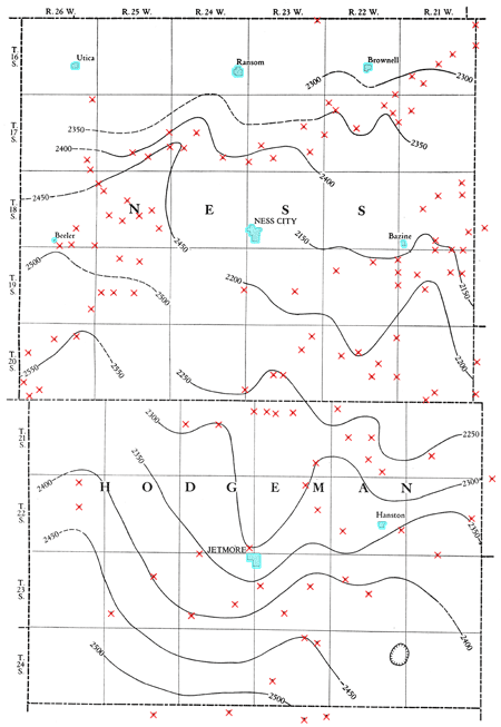
The regional dip of the Cretaceous strata in this general area is about 10 feet per mile slightly east of north. This structural slope has two northeastward-trending anticlines superimposed upon it in Ness and Hodgeman counties. One of these, here named the Beeler anticline, follows the west side of the two counties, and the other, here named the Bazine anticline, is in the eastern part of the two counties. The prominence of these anticlines is increased by the presence of a deep syncline in the vicinity of Jetmore. The anticlines are not high above the regional slope, but the syncline is considerably below.
Beeler Anticline
This anticline is the most prominent structural feature in the area. From available data the structure apparently trends due north along the west side of Hodgeman County and into Ness County as far as Beeler. Here it bends to the northeast and trends toward Ransom. The only place where data on the west flank are available is northeast of Beeler, in the south part of T. 17 S., R. 25 W., and in the southeast part of T. 17 S., R. 26 W., where there is a strong northwest dip.
Bazine Anticline
This anticline enters Hodgeman County from Ford County a little east of the Jetmore meridian and trends slightly east of north, passing between Jetmore and Hanston. North of here it makes a slight eastward swing and then trends nearly due north, passing just east of Bazine. The most prominent part of this structure is southeast of Bazine, in the central part of T. 19 S., R. 21 W., and in the west part of T. 20 S., R. 21 W.
Other Structures
The two anticlines described are the most outstanding in the area, but there are several anticlinal noses with some prominence. Two of these occur in the northwest part of Ness County, between Ness City and Brownell. Another occurs in T. 21 S., R. 24 W. and T. 20 S., R. 23 W.
Relation to Other Structures
The trend of these anticlines parallels the general anticlinal trend of the Upper Cretaceous rocks of western Kansas. The Beeler anticline lies about half way between the Cambridge anticline and the Stockton anticline (Bass, 1926, p. 88). The Bazine anticline is apparently a southward extension of the Stockton anticline.
Prev Page--Buried Rocks || Next Page--Economics
Kansas Geological Survey, Ness and Hodgeman Geology
Comments to webadmin@kgs.ku.edu
Web version May 2004. Original publication date Dec. 1, 1932.
URL=http://www.kgs.ku.edu/General/Geology/Ness/06_struct.html