![]()
Prev Page--Introduction || Next Page--Exposed Rocks
Geography and Topography
Location and Culture
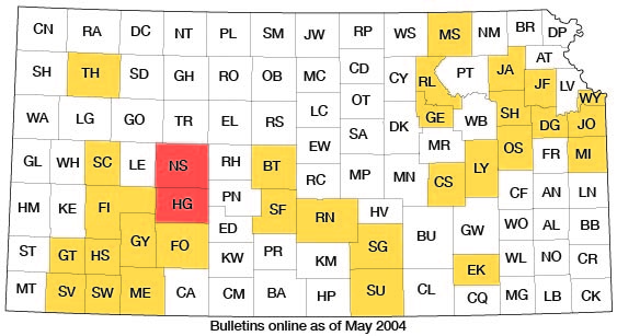
Ness and Hodgeman counties are located in central-western Kansas (Fig. 1). Ness County includes townships 16 to 20 south, and ranges 21 to 26 west, an area of approximately 1,080 square miles, or 691,200 acres. Hodgeman County is directly south of Ness County and includes townships 21 to 24 south, and ranges 21 to 26 west, an area of approximately 864 square miles, or 552,960 acres.
Figure 1--Index map of Kansas showing area described in this report and areas covered by other online geologic reports, as of May 2004. For additional information, please visit the KGS Geologic Maps of Kansas Page.
Ness County is served by two railroads, the Missouri Pacific and the Scott City branch of the Atchison, Topeka and Santa Fe. The Missouri Pacific crosses the northern end of the county, following the divide between Smoky Hill River and Walnut Creek. It runs through Brownell, Ransom, Arnold and Utica. The Scott City branch of the Atchison, Topeka and Santa Fe follows Walnut Creek in a westerly direction across the middle of the county, going through Bazine, Ness City and Beeler.
Hodgeman County is served by a spur line of the Atchison, Topeka and Santa Fe railroad, which leaves the main line at Larned and follows Pawnee River to the east line of Hodgeman County and then follows Buckner Creek, passing through Hanston and terminating at Jetmore.
U.S. Highway 50 North crosses Hodgeman County in an east-west line following Buckner Creek. A north-south state highway crosses the two counties, passing through Ness City and Jetmore, and two east-west state highways cross Ness County following the two rail roads. Practically all of the area of the two counties is accessible by graded county and township roads.
Ness County has a population of 8,358, and Hodgeman County has a population of 4,157 (1930 census figures). Ness City, the county seat of Ness County, has a population of 1,509, and Jetmore, the county seat of Hodgeman County, has a population of 914. Ransom and Bazine have a population of 431 and 423 respectively, and Utica has a population of 382. Hanston has a population of 254, Brownell 207, Beeler 110, and Arnold 90.
Most of the area of Ness and Hodgeman counties is in the Arkansas River drainage basin. Only a narrow strip, four to eight miles wide, along the north edge of Ness County drains into Smoky Hill River. All of Ness County, except the strip on the north edge and another along the south edge, drains into Walnut Creek, which rises in Lane County and flows eastward to join Arkansas River at Great Bend. All of Hodgeman County (except a small area in the southeast corner), and the southern end of Ness County, drain into Pawnee River, which rises in Finney County and joins Arkansas River at Larned about 25 miles east of the east line of Hodgeman County. Pawnee River flows through the northern part of Hodgeman County. Its largest tributary, Buckner Creek, rises in the northeast part of Gray County and flows northeastward, joining Pawnee River at a point about five miles south of the northeast corner of Hodgeman County. The largest tributary of Buckner Creek is Sawlog Creek, which rises in the northwest corner of Ford County and joins Buckner Creek at Hanston, in eastern Hodgeman County.
Topography
The total relief of the area is approximately 600 feet. The highest point, west of Utica on the divide between Smoky Hill River and Walnut Creek, has an elevation of about 2,650 feet, and the lowest point, where Walnut Creek leaves Ness County, has an elevation of 2,050 feet. Locally, however, the relief nowhere exceeds 300 feet. Physiographically, Ness and Hodgeman counties lie on the eastern edge of the High Plains and in the south part of the Blue Hills upland (Moore, 1930). The Ogallala capped divides (see Plates I and II) between the larger streams form the eastern margin of the High Plains, and the uplands formed by the Greenhorn limestone and the lower Carlile shale in eastern Ness County and northeast Hodgeman County compose the southern part of the Blue Hills upland. In southern Hodgeman County the Ogallala has overlapped the Niobrara, Carlile and part of the Greenhorn formations, so that the Blue Hills upland terminates to the south against a gently sloping Ogallala-covered plain which joins the Great Bend prairie to the east. This termination is due to the truncation and covering of northward-dipping Cretaceous strata by the eastward-dipping Ogallala, so that the Greenhorn and Ogallala escarpments converge in central Hodgeman County. A recent physiographic classification by Fenneman (1931) places this area in the plains border section of the Great Plains province.
The central parts of the divides between the major streams are flat and undissected and are sometimes poorly drained. An example of this is "Dutch Flats," a few miles northwest of Jetmore, where several small, intermittent lakes occur on the divide between Pawnee River and Buckner Creek.
Since the major drainage of the area is to the east, the divides trend and slope eastward. The south flanks of the divides slope rather gently to the streams, but the north flanks have short, steep slopes. This asymmetrical cross section of the divides and valleys has been explained by Bass (1929, p. 17) as being due to the greater effect of the erosive processes on the southward-facing slopes. The southward-facing slopes are usually covered by soil, and outcrops of bedrock are rare. Resistant beds make only a slight bench, if they have any expression at all. Contrasted with these gentle and smooth slopes the northward-facing slopes are usually terraced, due to differential erosion of alternating hard and soft strata, with large areas where there is not enough soil to support vegetation. The valleys that trend northward or southward have nearly symmetrical cross sections. When any difference can be noted, the westward-facing slope is usually the more gentle.
All of the major streams have developed flood plains, some of which are over two miles in width. Along their north sides the flood plains grade gently into the south-facing slopes, but on the south side there is usually a sharp break where they join the steep north-facing slopes. The streams usually flow along the south side of the flood plains, and for considerable distance they may mark the areal contact between the alluvium and bedrock. Exposures of bedrock arc very rare on the north side of the flood plains.
The flood plains, the southward-facing slopes, and the flat divides are utilized chiefly for cultivating wheat and corn, the chief agricultural products of the two counties. The "breaks" along the south side of the streams are mostly used for grazing purposes.
Prev Page--Introduction || Next Page--Exposed Rocks
Kansas Geological Survey, Ness and Hodgeman Geology
Comments to webadmin@kgs.ku.edu
Web version May 2004. Original publication date Dec. 1, 1932.
URL=http://www.kgs.ku.edu/General/Geology/Ness/03_geog.html