![]()
Prev Page--Contents || Next Page--Geography
Introduction
Purpose and Scope of Investigation
The investigation of the geology and ground-water resources of Neosho County was made in order to determine the quantity and quality of ground water available for domestic, stock, municipal, and industrial uses. The investigation upon which this report is based is part of a continuing program of ground-water investigations in Kansas begun in 1937 by the U. S. Geological Survey and the State Geological Survey of Kansas in cooperation with the Environmental Health Service of the Kansas State Department of Health, and the Division of Water Resources of the Kansas State Board of Agriculture.
Location and Extent of Area
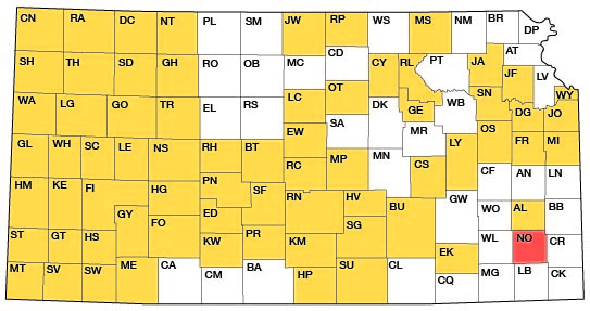
Neosho County, in southeastern Kansas, is bounded on the east by Bourbon and Crawford counties, on the north by Allen County, on the west by Wilson County, and on the south by Labette County (Fig. 1); it has an area of about 576 square miles.
Figure 1--Index map of Kansas showing area described in this report and areas covered by other online geologic reports, as of April 2009. For additional information, please visit the KGS Geologic Maps of Kansas Page.
Previous Investigations
The rocks that crop out in Neosho and adjacent southeastern Kansas counties have been studied and described by many workers. Some of the most significant reports are by Haworth (1915), Sayre (1930), Moore (1936) , Jewett (1941), 1945, 1951) Keroher and Kirby (1948), Howe (1956), Farquhar 1957). and Harbaugh (1959).
Studies pertaining to the ground-water resources of the area have been made by Bailey (1902), Haworth (1913), Moore, et al. (1940), Lohman, et al. (1942), and Williams (1944, 1948).
The oil and gas resources of Neosho County and adjacent areas have been discussed by Moore and Haynes (1917), Moore and Elledge (1920), Lee (1939), Jewett and Abernathy (1945), Jewett (1954), and Runnels, et al. (1952). Coal resources of the area have been studied by Whitla (1940), Schoewe (1944, 1955), Abernathy, et al. (1947), Hambleton (1953), and Schleicher and Hambleton (1954).
Methods of Investigation
Field work was begun in Neosho County in July of 1960. The geology was mapped in the spring and summer of 1961 and in the spring of 1962. Test holes were drilled in November of 1960 and July of 1964. Data were collected on 171 wells, which included the depth of the well and the depth to water in each well. Data concerning yield, type and depth of water-bearing material, and general quality of the water were obtained from well users. Fifteen test holes were augered and two were drilled with a cable-tool machine in the valley of the Neosho River to determine the thickness and lithologic properties of the alluvial material. Logs of the test holes were prepared in the field, and the drill cuttings were studied microscopically in the laboratory. Altitudes at the augered test holes were determined using an alidade and plane table. Altitudes of inventoried wells and the cable-tool test holes were interpolated from topographic maps of the area. Samples of water were collected from 42 selected wells. Chemical analyses of the water were made by the Environmental Health Service Laboratory of the Kansas State Department of Health
Well-numbering System
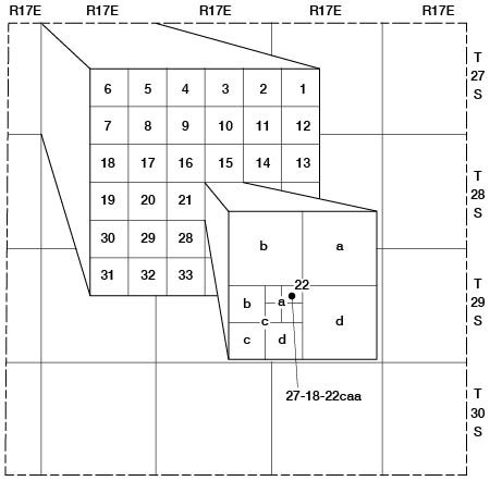
The well numbers used in this report are based on the location of each well according to the General Land Office survey of the area. The number contains, in abbreviated form, the township, range, section, quarter section, and quarter-quarter section of each location. When two or more wells are within the same 40-acre tract, they are numbered serially according to the order in which they were inventoried. The quarter sections within each mile section are designated a, b, C, and d in a counterclockwise direction, with a indicating the northeast quarter. The 40-acre tracts within each quarter section are designated in a similar manner. For example, well 27-18-22caa (Fig. 2) is in the NE NE SW sec. 22, T 27 S, R 18 E.
Figure 2--Map of Neosho County, Kansas, illustrating well-numbering system used in this report.
Acknowledgments
Appreciation is expressed to the many residents of Neosho County who supplied information concerning local geology, wells, and water supplies. John Bashor and Robert Williams, geologists, of the District Office of the Kansas State Department of Health at Chanute, supplied much information concerning the quality of round water from wells in Neosho County. Sutcliffe Pipe and Supply and James E. Guinotte, consulting geologist, contributed many driller's logs and other stratigraphic information. Jungmann Brothers Drilling Company, Inc., of Carbondale, Kansas, drilled the two cable-tool test wells in the Neosho River valley. The State Highway Department of Kansas made available much geologic information from their files, including geologic profiles of several highway projects. Stratigraphic sections and other unpublished data on the geology and groundwater resources of the area collected by members and former members of the U. S. and State Geological Surveys were utilized in the preparation of this report; their assistance is gratefully acknowledged.
Prev Page--Contents || Next Page--Geography
Kansas Geological Survey, Geology
Placed on web April 17, 2009; originally published December 1966.
Comments to webadmin@kgs.ku.edu
The URL for this page is http://www.kgs.ku.edu/General/Geology/Neosho/02_intro.html