![]()
Prev Page--Mineral Resources--Outcropping Rocks || Next Page--Ground-water Resources
Subsurface Rocks
Stratigraphy and Structure
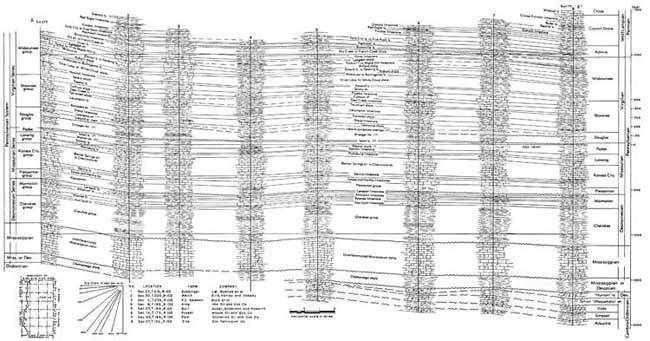
Conditions along a north-south line through the western part of Lyon County are shown on Figure 2, on which major rock units are differentiated.
Lyon County lies within the Forest City basin, being near the western flank of the basin and on the north flank of the Bourbon arch.
The surface rocks generally dip west by northwest, but as indicated by Figure 2, the subsurface units dip more northerly into the North Kansas basin.
The stratigraphy of the major rock units encountered in the subsurface of Lyon County is discussed in the following paragraphs.
Figure 2--Geologic cross section showing conditions along a north-south line through the western part of Lyon County, differentiating major rock units. In center column for "Dry Creek Shale" read Dry shale. A larger Acrobat PDF version of this figure is available.
Permian Rocks
Thickness of the Council Grove group is uniformly about 320 feet in Lyon County. The Admire group is uniformly about 130 feet thick throughout the county.
Pennsylvanian Rocks
Pennsylvanian rocks do not have a constant thickness in Lyon County due to slight lateral changes in thickness of the formations and because Pennsylvanian rocks present in the subsurface of the western part of the county have been removed from the eastern exposed part by erosion. The westward-dipping surface rocks have been beveled by erosion. Pennsylvanian rock groups in Lyon County do not differ greatly in thickness and lithology from those of the surrounding counties.
The Wabaunsee and Shawnee groups are typically composed of shale and thin limestone beds. The Douglas group is predominantly composed of clastic materials with known formations difficult to differentiate. Thickness of Douglas rocks differs as shown by Figure 2, indicating local erosion of Missourian rocks (Pedee) before deposition of Douglas rocks. The Lansing and Kansas City groups are made up almost entirely of limestones. The Pleasanton shale averages about 100 feet in thickness throughout the county. The Marmaton limestones are separated by thin shales, their thicknesses remaining nearly constant. Cherokee rocks are composed of about 300 feet of shales with some thin limestones and sandstones. In the southern part of the county, the "Bartlesville sand," in the lower part of the Cherokee group, has yielded oil.
Mississippian Rocks
Thickness of Mississippian rocks in Lyon County ranges from about 300 feet in the northeastern corner to more than 400 feet in the central eastern part (Lee, 1943, fig. 16). The Chattanooga shale, averaging slightly more than 100 feet in thickness, progressively overlaps from north to south on beveled older rocks ranging in age from Devonian to middle Ordovician.
Pre-Chattanooga Rocks
The Chattanooga shale in most of Lyon County is believed to lie on the Viola limestone (Ockerman, 1935, fig. 2). In the northern part of the county, the "Hunton" limestone underlies the Chattanooga shale and the pre-Chattanooga outcrops of the "Hunton" and Viola limestones are separated by about 75 feet of Sylvan (Maquoketa) shale (Fig. 2). The interval between the base of the Chattanooga shale and the top of the Sylvan (Maquoketa) shale is about 100 feet (Lee, 1943, fig. 12) in the northern part of the county. The total thickness of the rocks between the top of the Sylvan (Maquoketa) shale and the top of the St. Peter sandstone is probably less than 150 feet everywhere in the county, and the interval from the top of the St. Peter to the Precambrian ranges from about 300 to 800 feet.
The thickness of the Jefferson City-Cotter sequence in Lyon County has been estimated by Keroher and Kirby (1948, figs. 4, 6, 8, 9) as ranging from about 100 feet in the northwestern part of the county to about 375 feet in the southeastern part; the Roubidoux dolomite, from less than 100 feet in the southeastern part to slightly more than 150 feet in the northwestern part; the Van Buren-Gasconade sequence, believed to be absent in the western half of the county, from a featheredge to a thickness of less than 50 feet in the eastern part; the Bonneterre dolomite from a featheredge in the southeast corner to a maximum of more than 100 feet in the northeast part.
Oil and Gas
Secondary Recovery
The first reported secondary recovery operation in Lyon County was in the Lyon County portion of the Fankhouser field in 1943 (Jewett, 1949, table 3). This project grew from 30 acres in extent to more than 100 acres at the end of 1951. Secondary recovery is being carried on in the Atyeo field at the present time also. More than 85 percent of the oil produced in the county during the past three years is credited to recovery by water-flood projects. The calculated water-flood reserves as of January 1, 1948, were more than 4 million barrels of oil (Sweeney, 1949, p. 23).
Exploration and Production
Until the discovery of commercial quantities of oil in the Bushong field in 1950, oil was produced only in the southern part of Lyon County. Exploration has been concentrated in the western and southern parts of the county. According to available records, 446 holes have been drilled in Lyon County in search for oil or gas. Of these, 122 have produced oil in the past or are producing at present.
Producing formations--The rocks in which oil has been found are the "Bartlesville shoestring sand" in the Cherokee shale of middle Pennsylvanian age, the Osagian Series of the Mississippian System, the "Hunton" limestone of late Devonian age, and the Viola (Kimmswick) limestone of middle Ordovician age. No commercial quantities of gas have been reported as produced in the county.
Although 20 holes have been drilled into Arbuckle dolomite or older rocks, no oil or gas has been found in them. Survey files contain records of only one hole drilled to Precambrian rocks. Locations of oil wells and dry holes and their stratigraphic depths are shown on Plate 2.
Drilling activity in recent years--In 1949, 11 dry holes were reported drilled in the county. Of these, one was an extension well in the Fankhouser field, one was an extension well in the Ott (Greenwood County) field, and nine were dry wildcat wells (drilled more than 2 miles from existing production). Only one of the dry wildcats did not penetrate the Arbuckle dolomite (lower Ordovician). They were concentrated in the western half of the county (Ver Wiebe and others, 1950).
In April 1950 the Stanolind Oil and Gas and Winkler and Koch No. 1 Cornwell well in the NE NE NE sec. 26, T. 16 S., R. 10 E. discovered a new producing formation, the "Hunton" limestone (late Devonian age) resulting in a new oil field, the Bushong. During 1950, one dry extension well was added to the new field. In all, 27 tests were made in Lyon County in 1950. Extension wells added one dry hole to the Bradfield field (now inactive), six oil wells and four dry holes to the Fankhouser field, and one oil well and one dry hole to the Rock Creek field. The remaining 13 tests were dry wildcats concentrated in the western half of the county (Ver Wiebe and others, 1951).
During 1951, 15 wells were drilled in the county. Of these, one dry hole was added to the Bushong field, two oil wells and three dry holes to the Fankhouser field, one dry hole to the Richey-Moore field (now inactive), and one oil well and one dry hole to the Rock Creek field. Three of the six dry wildcat tests penetrated the Arbuckbe dolomite (Ver Wiebe and others, 1952).
Oil Fields
Atyeo field--The Atyeo field straddles the junction of Lyon, Chase, and Greenwood counties. The Lyon County part is located in secs. 19, 30, and 31, T. 21 S., R. 10 E. The discovery well of the field is believed to be in the SE SW sec. 30, T. 21 S., R. 10 E. Production comes from the "Bartlesville sand" at an average depth of about 2,200 feet. The daily initial production of various wells ranged from less than 10 to more than 500 barrels of oil per day. Of 95 holes drilled in the field, 11 were dry and 55 have produced oil; only 34 now produce in the Lyon County part of the field. In 1949, production from 45 wells was 391,013 barrels. In 1950, 45 wells produced 296,131 barrels, and in 1951, 34 wells produced 229,271 barrels of oil (Ver Wiebe and others, 1950, 1951, 1952).
Bradfield field--According to Landes (1937, p. 57), oil was first discovered in Lyon County in the Bradfield field in Ordovician sandstone in 1922. The Bradfield field (now inactive) is in secs. 24 and 25, T. 21 S., R. 10 E. Some wells in the area had reported initial production of more than 1,000 barrels of oil daily, production coming from depths of 2,200 to 2,600 feet, probably from the Viola (Kimmswick) limestone. According to Survey records, of 22 holes drilled in the field, seven were dry and 15 produced oil in the past. Production during 1925 was reported as 27,515 barrels of oil. No field production figures are available for succeeding years.
Bushong field--The Bushong field was discovered in 1950 by the Stanolind Oil and Gas Company and Winkler and Koch No. 1 Cornwell well in the NE NE NE sec. 26, T. 16 S., R. 10 E. The discovery well was rated at 257 barrels of oil per day from the "Hunton" limestone at depths of 2,950 to 2,967 feet. Later in the year a dry extension well was added to the field in the NE SE SE sec. 23, T. 16 S., R. 10 E. From April to November 1950, 4,334 barrels of oil were marketed from this one well. During 1951 the well produced 5,705 barrels of oil (Ver Wiebe and others, 1951, 1952).
Fankhouser field--The Lyon County part of the Fankhouser oil field is located in secs. 29, 31, 32, and 33, T. 21 S., R. 12 E. The field was extended from Greenwood County in 1926. The depth to the producing "Bartlesville sand" is about 1,850 feet. Of 62 holes drilled in the Lyon County part of the field, 22 were dry and 40 have produced oil, 23 wells now producing. In 1949, the total production of the Lyon County part was 28,224 barrels, in 1950, 50,380 barrels, and in 1951, 48,683 barrels of oil (Ver Wiebe and others, 1950, 1951, 1952).
Richey-Moore field--The Richey-Moore oil field formerly produced from the upper part of the Mississippian limestone. The discovery well, drilled in 1925, is believed to have been in the SE corner SW sec. 34, T. 21 S., R. 10 E. Production came from a depth of about 2,200 feet. Of 12 wells drilled in the field, nine were dry and three produced oil. No Richey-Moore field production figures are available.
Rock Creek field--The Rock Creek field is located in secs. 29 and 32, T. 21 S., R. 11 E. The discovery well, the Murphy et al. No. 1 Fee well in the NW NW NE sec. 32, T. 21 S., R. 11 E., found initial daily production of 35 barrels daily from the "Bartlesville sand" at depths of 1,930 to 1,942 feet. Four producing wells were completed during 1947, the discovery year, and reported production was 4,440 barrels. Six dry extension wells were added to the field during 1948, when marketed production was listed as 5,544 barrels of oil (Jewett, 1949). In 1949, four producing wells yielded 4,371 barrels. In 19S0, one oil well and one dry hole were added to the field; production from four wells was 3,089 barrels. Three producing wells reported 3,131 barrels of oil marketed in 1951 (Ver Wiebe and others, 1950, 1951, 1952).
Prev Page--Mineral Resources--Outcropping Rocks || Next Page--Ground-water Resources
Kansas Geological Survey, Lyon County Geohydrology
Web version Sept. 2001. Original publication date March 1953.
Comments to webadmin@kgs.ku.edu
The URL for this page is http://www.kgs.ku.edu/General/Geology/Lyon/pt2_subs.html