![]()
Prev Page--Stratigraphy--Tertiary || Next Page--Stratigraphy--Pennsylvanian
Stratigraphy of Outcrops, continued
Permian System
Wolfcampian Series
Chase Group
Barneston Limestone
The Barneston limestone consists of three members, Fort Riley limestone at the top, Oketo shale, and Florence limestone. Only the lower member crops out in Lyon County. It is not an aquifer.
Florence Limestone member--The complete thickness of the Florence limestone is 35 to 40 feet. In the few exposures of this limestone in Lyon County somewhat less than the full thickness is present as small outliers in the northwest corner of the county. It consists of bight-gray to yellowish-gray fossiliferous limestone containing an abundance of dense blue-gray fossiliferous chert nodules. Thin fossiliferous shale breaks occur in the bower part. Fossils include fusulinids, bryozoans, brachiopods, corals, and mollusks.
Matfield Shale
The Matfield shale, including two shale members and one limestone member, has a thickness of about 55 to 60 feet. It is of little importance as an aquifer.
Blue Springs shale member--Exposures of the Blue Springs shale in Lyon and adjacent counties indicate a thickness of about 15 to 18 feet of gray, gray-green, and red shale, with one or more limy zones in the upper part.
Kinney limestone member--Gray limy shale and shaly limestone about 16 feet in thickness comprise the Kinney limestone. The shales and limestones are abundantly fossiliferous. Fossils include bryozoans, brachiopods, echinoids, crinoids, pelecypods, and abundant ostracodes. It is nonresistant to weathering and makes little or no bench in the topography. The limestones in the basal part are the most massive resistant beds. The abundant fossils and limyness of the Kinney limestone serve to distinguish these beds from essentially nonfossibiferous red and green shales of adjacent members and to correlate them with areas in which the Kinney limestone contains resistant hard zones which make prominent outcrops.
Wymore shale member--The average thickness of the Wymore shale is approximately 27 feet. Tan to gray-green shale occurs in the upper part, red and green blocky shale in the middle, and hard tan, gray, or olive shale in the basal part. It is unfossiliferous except for sparse fossils locally in the upper part.
Wreford Limestone
The thickness of the Wreford limestone is about 40 feet. Small supplies of ground water are obtained from this limestone locally.
Schroyer limestone member--The average thickness of the Schroyer limestone is about 8 or 9 feet, the lower 4 feet of which contains abundant nodules of dense, blue-gray chert. Frequently a thin shale occurs near the middle of the member. Fossils include brachiopods, bryozoans, and echinoderms, none of which is abundant. The limestone is dolomitic in the lower cherty part, ranging from gray to light-brown in color.
Havensville shale member--Excellent exposures in the Missouri Pacific Railroad cuts west of Bushong and along U.S. 50-N show the Havensville shale to average 15 to 17 feet in thickness. It consists chiefly of gray and tan shale with a thin band of green near the middle. The bower half contains many fossils, especially brachiopods. Two thin limestones are persistent, one near the middle of the member is impure and shaly, the other about 3 feet higher is hard, shelly, and abundantly fossiliferous.
Threemile limestone member--The Threemile limestone forms a strong rounded bench along its line of outcrop. Massive thick beds of light-gray limestone with abundant nodules and bands of dense gray chert comprise the entire thickness of the member, except for a thin gray to olive shale about 3 feet above the base. Numerous fossils, many of which are silicified, occur in the limestone, shale, and chert; brachiopods, bryozoans, and echinoderms are the most abundant. The member ranges in thickness from 13 to 17 feet.
Council Grove Group
Speiser Shale
The upper 3 feet of the Speiser shale is gray calcareous shale with a thin shaly limestone or mudstone at its base. This part contains abundant brachiopods, bryozoans, and echinoderm fragments. The middle and lower parts comprise red and green shale, locally with an intraformational conglomerate a few feet above the base. The conglomerate consists of pebbles of lithified red and green shale together with gray and tan limestone pebbles which range in size from one-fourth to 2 inches in diameter. Fragments of bones and several teeth were observed in the conglomerate. Thickness of the Speiser shale is about 15 feet. It is not important as an aquifer.
Funston Limestone
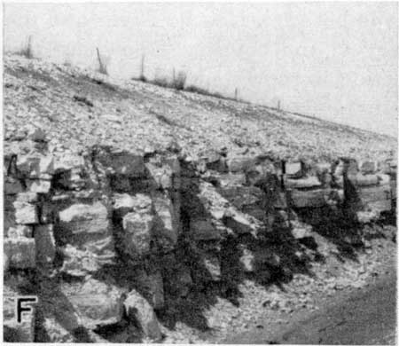
In measured sections the Funston limestone ranges from 22 to 28 feet in thickness and shows variableness in the lithology of its parts. However, in this area a persistent algal limestone is present at the base (Pl. 4E), as was observed in Chase County (Moore, Jewett, and O'Connor, 1951, p. 11, pl. 4E). The top of the limestone is frequently, though not always, marked by dense platy beds of algal limestone. The change to bright red or green shales of the Speiser shale readily marks the top of the formation where other identifying features are absent. Between the algal limestones at top and base occur platy hard limestones, coarse detrital beds of limestone, bedded sandy limestone or limy sandstone, and tan, gray, and black shales. Common fossils in addition to cabcareous algae are mollusks, bryozoans, and brachiopods. Resistant beds which make prominent hillside outcrops (Pl. 4F) are not restricted to a particular part of the formation, but may occur in the lower, middle, or upper part. Locally it is a source of small supplies of ground water.
Plate 4E--Basal algal bed of Funston limestone showing abundant algal colonies, SE SE sec. 7, T. 16 S., R. 10 E.
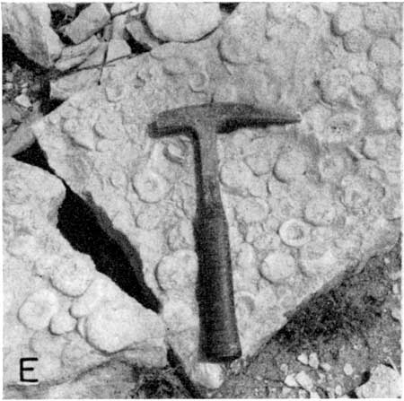
Plate 4F--Speiser shale and upper platy and massive beds of Funston limestone along US 50-N, SE sec. 7, T. 16 S., R. 10 E.
Blue Rapids Shale
The Blue Rapids shale ranges in thickness from about 21 to 25 feet. Green and red shale with an impure "boxwork" limestone near the middle comprise most of the unit. Tan or gray shale occurs in the upper part and commonly a thin coal smut or carbonized plant remains are present a short distance below the algal limestone at the base of the Funston. Ostracodes occur abundantly locally above the coal smut. The formation supplies little or no water to wells.
Crouse Limestone
The easily recognized Crouse limestone consists of two persistent beds of limestone separated by 8 to 12 feet of gray or tan shale which is abundantly fossiliferous in the lower and middle parts. The upper limestone is gray to tan platy limestone in the upper part, with banded or lobate algal (?) structures exhibited locally. The lower part of this upper limestone is massive, hard, tan or gray limestone containing small rounded pebbles of hard shale and limestone and abundant mollusks. This ledge typically makes a prominent outcrop. The underlying shale is tan, gray, or gray blue, locally gypsiferous, with abundant bryozoans, brachiopods, and sparse echinoderms in the lower half or less. The basal limestone is 2 to 3 feet in thickness, somewhat shaly or silty, and less prominent as an outcrop maker. Mollusks and algae are the common fossils of this bed. Thickness of the formation is about 18 feet. It is the source of small supplies of ground water for a considerable number of farm wells.
Easly Creek Shale
The average thickness of the nonfossiliferous Easly Creek shale is about 10 feet. It consists chiefly of red and green shale but locally contains some gray or tan shale. A zone of nodular limestone or "boxwork" occurs near the middle. It supplies little or no water to wells.
Bader Limestone
The thickness of the Bader limestone is about 33 feet. It is a source of small supplies of ground water for stock and domestic wells.
Middleburg limestone member--The Middleburg limestone has an average thickness of 7 or 8 feet. At the top is 0.5 to 2 feet of tan to gray platy limestone and massive molluscan limestone. Underlying this is 2 to 4 feet of tan, gray, or black shale. Next below is 1 to 2 feet of gray limy shale or shaly limestone containing sparse brachiopods. At the base is a 3-foot light-gray slightly shaly limestone containing abundant mollusks, bryozoans, and a few echinoderms.
Hooser shale member--Measured sections of the Hooser shale show it to consist of tan or gray shale in the upper part, green and red shale in the middle and lower parts. Frequently a nodular or "boxwork" limestone occurs near the middle. The member commonly is about 9 feet thick.
Eiss limestone member--The Eiss limestone comprises about 17 feet of limestone and shale beds. The upper 1.5 to 3 feet is light- to dark-gray granular to dense limestone which weathers pitted and rough. Locally the bed may have a lavender tint or may contain sparse chert nodules. Simple forms of calcareous algae and mollusks are the chief fossils but locally other fossils are present. Gray, olive, green, or nearly black shale about 9 feet in thickness including abundant mollusks, bryozoans, brachiopods, and echinoderms occurs in the middle part. In the northern part of Lyon County the lower limestone is essentially one bed of gray shaly limestone but when traced southward it expands into two limestones separated by several feet of shale. Locally the lower beds may contain sparse chert nodules.
Stearns Shale
Measured sections of the Stearns shale show it to thin southward from about 11 feet in northern Lyon County to approximately 5 feet in exposures near the southwest corner of the county. In northern areas it consists of gray and olive shale in the upper part together with a thin coal bed or abundant carbonized plant remains. Locally ostracodes are abundant above the coal bed zone. Near the middle a nodular or "boxwork" limestone commonly occurs. The lower part consists of green shale with occasional streaks of red. Exposures of this shale in southern areas lack the coal but in other respects are very similar. It is not important as a source of ground water.
Beattie Limestone
The thickness of the Beattie limestone average about 21 feet in Lyon County. Both limestone members are important aquifers and supply numerous stock and domestic wells.
Morrill limestone member--Measured section of the Morrill limestone range from about 3 to 5 feet in thickness. It consists of gray, tan, and brown limestone generally with one or more thin shale partings. Lithology of the beds varies fron hard, dense, or granular limestone to soft porous limestone, or occasionally limestone beds with considerable detrital limestone and shale grains included in them. Algae and mollusks are the most abundant fossils but foraminifera and sparse brachiopods are observed occasionally. In the northern outcrops a siliceous bed occurs at the base of the member.
Florena shale member--The middle member oI the Beattie limestone comprises 11 to 14 feet of blue-gray or tan calcareous shale with abundant brachiopods, bryozoans, and crinoids especially in the lower and middle parts. Fusulinids sometimes occur in the basal few inches just above the Cottonwood limestone.
Cottonwood limestone member--The Cottonwood limestone averages about 6 feet in thickness and is characterized by the prominent outcrop which it makes. It is the youngest or uppermost bed in the Council Grove group which regularly contains fusulinids. Fusulinids are abundant in the upper half or less and weather into relief on outcrops. Brachiopods and echinoderms are the principal fossils in the remainder of the bed, but zones of algal limestone are conspicuous locally. Scattered nodules of chert commonly occur in a zone near the middle of the bed. Solution channels and cavernous zones are observed in many exposures. The rock is light gray in color and weathers nearly white.
Eskridge Shale
The average thickness of the Eskridge shale is about 34 feet. The upper few feet is generally gray or tan calcareous shale, whereas the middle and lower parts consist chiefly of green and red shale with two rather persistent thin molluscan limestones. Locally, gray or tan shale may occur in the middle or lower part. A thin impure coal is observed locally between the lowermost molluscan limestone and the top of the Neva limestone between Neosho River and the south boundary of the county. Elsewhere this part of the section is represented by a "boxwork" limestone and green, red, and gray shale. The formation exhibits marked variations in its composition over short distances. Although not a consistent aquifer, it supplies small amounts of ground water to several wells in this area.
Grenola Limestone
The average thickness of the Grenola limestone, which comprises three limestone and two shale members, is about 35 feet. It is the principal aquifer for many small stock and domestic wells.
Neva limestone member--The Neva limestone ranges in thickness from about 9 to 15 feet, being thinnest in the northern part of the county. Several persistent zones are recognized. The upper bed consists of 1 to 3 feet of hard gray algal molluscan limestone which frequently contains numerous brachiopod and echinoderm remains. The main ledge of the Neva, 3 to 8 feet thick, occurs near the middle of the member and is distinguished by its pitted rough-weathering character, its cavernous zones, and its fossils. Fossils in this bed are chiefly brachiopods and echinoderms with fusulinids near the base. Separating the two limestones is a gray or tan shale, 0.7 to 6 feet thick containing brachiopods, bryozoans, and echinoderms. The lower 2 to 5 feet of the Neva limestone comprises two or three thin limestones separated by tan, gray, or black shales. The shales are frequently but not always fossiliferous. The thin limestones contain abundant fusulinids together with brachiopods, bryozoans, and echinoderms. The basal limestone is everywhere observed to be algal. Mollusks and ostracodes are associated with the algal bed. Sparse chert nodules may occur in the middle and lower limestones.
Salem Point shale member--The thickness of the Salem Point shale averages about 7 feet. It is gray to olive, silty, calcareous shale which weathers tan. Locally it is sandy in the lower part.
Burr limestone member--The Burr limestone, averaging 8 feet in thickness, generally consists of several thin limestones separated by shales. In most sections a thin limestone bed underlain by 1 to 4 feet of olive or gray shale occurs at the top. A persistent tan platy limestone occurs next lower underlain by shaly or silty gray molluscan limestones and dark or black shale. Ostracodes occur commonly at the top of the platy beds. Calcareous algae are abundant; other fossils, including bryozoans and brachiopods, occur less abundantly.
Legion shale member--At measured exposures the Legion shale is 5 to 9 feet thick, unfossibiferous, gray, olive, and tan shale. In the northern part of Lyon County a few inches of black fissile shale occurs at the base.
Sallyards limestone member--The Sallyards limestone is a thin, gray, silty or shaly molluscan bed 0.3 to 2 feet thick in the north and thickens southward to about 5 feet. Where thick it contains mollusks and echinoderms.
Roca Shale
Exposures of the Roca shale average about 18 to 21 feet in thickness except in T. 15 S. where the Roca thins abruptly over the Red Eagle bioherm. Less than 4 feet of Roca occurs in parts of this area. It comprises chiefly red, green, and olive shale, locally with a "boxwork" type limestone in the upper part. The lower part contains one or more beds of gray dense limestone and limy nodules with specks and veinlets of clear crystalline calcite.
The Roca shale is not important as an aquifer.
Red Eagle Limestone
The thickness of the Red Eagle limestone ranges from about 10 to 33 or more feet. Throughout most of its line of outcrop it has a thickness of 12 to 16 feet. A considerable number of wells derive water supplies from the Red Eagle limestone chiefly from limestone in the Bennett shale and from the Howe limestone. Member boundaries conform with those of O'Connor and Jewett (1952).
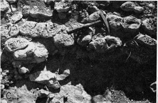
Howe limestone member--The Howe limestone is a gray to gray-brown algal (Pl. 5C) and foraminiferal limestone ranging in thickness from about 1 to 6 feet. Its lithology and fauna are exceedingly persistent and uniform all along its outcrop in central Kansas, small foraminifera, calcareous algae, tiny snails, and ostracodes being exceedingly abundant. Except in the thicker sections it ordinarily does not make a conspicuous outcrop. It is thickest in T. 15 S., in the area of the Red Eagle bioherm (O'Connor and Jewett, 1952).
Plate 5C--Unidentified algal colonies at the top of the Howe limestone, C E line sec. 34, T. 15 S., R. 11 E.
Bennett shale member--Measured sections of the Bennett shale range from about 6 to 27 feet in thickness. It comprises olive, gray, and black shale beds and tan, light-gray, or nearly white limestone and dolomitie limestone. The upper and middle parts, except in the bioherm developed in T. 15 S., comprise chiefly gray and olive-gray calcareous or limy shale containing abundant echinoid and crinoid fragments, brachiopods, and bryozoans. In a few exposures this part of the Bennett may contain sparsely fossiliferous or non-fossiliferous shale adjacent to or within the abundantly fossiliferous parts. Next lower is a persistent dolomitic limestone, light gray to nearly white in color, massive, cavernous, occasionally sparsely cherty and generally the best bench maker of the Red Eagle formation. In many outcrops it contains few or no recognizable fossils, and has a somewhat brecciated appearance. In other outcrops sparse horn corals, brachiopods, echinoderms, and calcareous algae are observed. The lower part of this limestone or adjacent underlying gray or black fissile to thin-bedded shale beds contains specimens of shiny red-brown Orbiculoidea. Although the lithology of the Bennett shale may change laterally from shale to limestone or limestone to shale the Orbiculoidea zone and the mixed fauna zone of the upper and middle parts persist entirely across Lyon County and almost without exception can be traced entirely across the state (O'Connor and Jewett, 1952).
Locally in secs. 23, 24, and 26, T. 15 S., R. 11 E., the Howe and Bennett members expand abruptly in a bioherm development and are entirely limestone and dolomitic limestone except for a thin shale at the base of the Bennett member. In the bioherm the Bennett comprises about 12 or 13 feet of light-gray coarsely crystalline and brecciated limestone which contains at one outcrop in sec. 23, T. 15 S., R. 11 E., masses of beautifully preserved segments of crinoids, large brachiopods, and other fossils. This part of the Bennett in most of the bioherm does not form a strong outcrop. Next lower is about 14 feet of light-gray to light-tan cavernous cherty and massive dobomitic limestone or dolomite which makes a strong bench. Fossils are not abundant but include corals, calcareous algae, echinoderms, brachiopods, and fusulinids. Stylolites are common in this bed and it is evident that diagenetic processes have altered the original sediment considerably.
Next lower occurs generally less than 1 foot of tan dolomite containing Orbiculoidea underlain by about 1 to 5 feet of gray to black thin-bedded or fissile shale generally also with Orbiculoidea.
Glenrock limestone member--The Glenrock limestone is light-gray to tan limestone which ranges from a featheredge to about 1.5 feet in thickness. It is characterized by abundant fusulinids in the upper part of the bed or locally the entire bed. The lower part is a detrital nonfusulinid bed in some exposures.
Johnson Shale
The average thickness of the Johnson shale is about 20 feet. North of Cottonwood River the upper 1 to 5 feet is gray or tan shale with carbonized plant remains in the lower part. In southern parts of the county the entire thickness of this part may be black carbonaceous shale. Next below is an unfossiliferous dense or fine-grained limestone or platy mudstone which ranges in thickness from less than 0.5 to about 5 feet. Beds below this are variable in lithobogy but comprise calcareous tan, gray, and green shales, impure limestones, and locally thin beds of gypsum. The formation generally yields little or no water to wells; however, gypsiferous zones in the lower part occasionally yield small supplies of ground water.
Foraker Limestone
Exposures of the Foraker limestone average about 40 feet in thickness. The upper member is an important aquifer and supplies numerous wells with small to moderate amount of generally good quality water.
Long Creek limestone member--The Long Creek limestone is a nonresistant dolomitic limestone. It contains a zone of geodes and scattered crystals of red, orange, or colorless quartz and chert together with colorless celestite at or near the top of the member. Upon weathering the distinctive quartz-celestite zone makes an easily recognized marker along the outcrop of the bed. The limestone is 3 1/2 to 6 feet in thickness, sucrosic to granular or fine-grained, and brown or tan in color. Frequently cavernous zones develop in the part containing the quartz-celestite geodes. Recognizable fossils are sparse in many exposures but calcareous algae and mollusks are the principal fossils observed.
Hughes Creek shale member--Near the top of the Hughes Creek shale a 2- to 3-foot bed of shaly gray limestone containing abundant fusulinids is present, separated from the overlying Long Creek limestone by a few inches to about 3 feet of gray to olive thin-bedded shale. The remainder of the member consists of gray to nearby black shale containing abundant brachiopods, bryozoans, and echinoid and crinoid fragments, generally associated with very abundant fusulinids. In many places where the Hughes Creek shale crops out across secondary roads, the small wheat-shaped fusulinids form a veneer of unusual "gravel" on the surface. Approximately 5 feet above the Americus limestone a thin, gray molluscan limestone less than 1 foot thick occurs as a marker bed, distinct from the brachiopod and fusulinid limestones in the remainder of the member.
Americus limestone member--The Americus limestone comprises two limestones separated by several feet of. shale. Its average thickness is about 11 or 12 feet. The upper limestone is medium to dark-gray hard limestone 1 to 2 feet thick containing chiefly brachiopods and crinoids. Next below is 2 to 4 feet of olive to gray calcareous shale underlain by 2 to 4 feet of black fissile shale mottled with brown. Gray shaly limestone 0.5 to 2 feet thick containing fusulinids, brachiopods, bryozoans, and crinoids occurs below the black shale. At the base is the "main ledge" of the Americus limestone, 0.8 to 1.5 feet in thickness, with the same fauna as the overlying shaly limestone. This ledge can be quarried in large rectangular blocks because of its widely spaced joints.
Admire Group
Hamlin Shale
The Hamlin shale has an average thickness of about 55 feet. It is of little importance as a source of ground water.
Oaks shale member--Measured sections of the Oaks shale range from 2 to 9 feet in thickness and average about 5 feet. It is chiefly olive-gray and black shale, occasionally gypsiferous.
Houchen Creek limestone member--Gray limestone composed largely of calcareous algae and yellow-brown sandy, conglomeratic, or "honeycomb" limestone make this bed a distinctive marker. It ranges in thickness from 0.5 to about 3 feet.
Stine shale member--The Stine shale ranges from about 49 to 53 feet in thickness. The upper one-third generally consists of gray or olive shale locally containing a thin sparsely fossiliferous limestone. A few feet above the middle a thin sandstone or pebbly conglomerate frequently is observed. The middle and lower parts comprise red and green silty or sandy micaceous shale, gray and olive shale, and locally thin impure limestones. Terrestrial plant remains and Lingula are the common fossils observed.
Five Point Limestone
In most exposures the Five Point limestone is a single bed of abundantly fossiliferous gray limestone, but occasionally it contains one or more thin shale partings. Thickness of the formation ranges from 1.4 to 2.5 feet. Fossils include fusulinids, brachiopods, bryozoans, horn corals, and crinoids. It is of little importance as an aquifer.
West Branch Shale
Measured sections of the West Branch shale range in thickness from 25 to 29 feet. A persistent coal ranging in thickness from about 0.8 foot to little more than a smut occurs about 1 foot below the Five Point limestone. Locally there are two thin coals separated by shale beds. The upper part, below the coal, consists of thin gray shale and friable micaceous sandstone or sandy shale. The sandstone ranges upward to about 8 feet in thickness, is gray to gray green in color, and weathers brown. Plant remains are associated with the sandstone. In the lower middle part, a very pyritic or bimonitic limestone or zone containing limonite pseudomorphs of pyrite crystals occurs underlain by red shale locally. The basal beds are gray shale, frequently with numerous dense siltstone concretions. Beds of sandstone in the West Branch shale frequently yield small supplies of ground water to wells.
Falls City Limestone
The Falls City limestone ranges in thickness from about 10 to 16 feet. The upper part consists of one limestone, or two limestones and a thin shale, associated with one or more zones of cone-in-cone. The limestone beds are dark gray, silty, and fine-grained with abundant fossils, mostly mollusks but including bryozoans, crinoids, and brachiopods. Lower beds generally include two or more thin silty or clayey gray or tan limestones containing coquinas of small crystalline mollusks interbedded with gray, olive, or tan shale. In southern Lyon County these beds become very shaly but retain their abundant fossils. Over most of the line of outcrop the limestones are too thin and weak to form a bench in the topography. Locally this formation is a source of small supplies of ground water of variable quality.
Hawxby Shale
The average thickness of the Hawxby shale is about 10 or 12 feet. It comprises olive, gray, green, and red unfossiliferous shale. Locally, near the middle of the formation a zone of mudcracks and pebbles of limestone occurs at the top of red shale. It supplies little or no ground water to wells.
Aspinwall Limestone
The Aspinwall limestone, overlain and underlain by the nonfossiliferous red, green, and olive Hawxby and Towle shales, is variable in thickness, lithology, and position with respect to the next lower limestone formation. In some exposures it comprises several thin mollusk, brachiopod, and bryozoan-bearing limestones and separating beds of shale. Other exposures show a shell hash or lag concentrate of mollusks, bryozoans, and brachiopods. This is interpreted as indicating shallow marine conditions just prior to Hawxby time, in which the thin fossiliferous limestones and shales of the Aspinwall formation locally were subject to wave and current action for a short length of time. During this time the finer sediments of the original thin fossiliferous limestone and shale beds and varying amounts of the underlying Towle shale were removed and redeposited elsewhere, leaving a coquina of the relatively coarse and heavy fossil shells behind. In some areas these shells were left as essentially even-bedded lag deposits; elsewhere they were concentrated into banks of shells as much as 6 or more feet in thickness, unconformably on the beds below. Where the Aspinwall is represented by good beds of "shell hash" limestone, it is a source of good supplies of water for stock and domestic wells but quality of water is variable.
Towle Shale
The Towle shale ranges in thickness from a featheredge to about 20 feet. It comprises an unnamed shale in the upper part and the discontinuous Indian Cave sandstone in the lower part. It is of little importance as an aquifer.
Unnamed shale member--These strata generally display gray, tan, or olive shale in the upper part, red or red and green in the middle, and olive, gray, or green shale in the basal part. The beds are slightly sandy and micaceous in some exposures.
Indian Cave sandstone member--No beds assignable to the Indian Cave sandstone were recognized in Lyon County. However, were the variations in the nature of the Aspinwall limestone not recognized and proper attention given to the stratigraphic sequence, it is possible that certain fades of the Aspinwall limestone could be mistaken for the Indian Cave member.
Prev Page--Stratigraphy--Tertiary || Next Page--Stratigraphy--Pennsylvanian
Kansas Geological Survey, Lyon County Geohydrology
Web version Sept. 2001. Original publication date March 1953.
Comments to webadmin@kgs.ku.edu
The URL for this page is http://www.kgs.ku.edu/General/Geology/Lyon/pt1_perm.html