![]()
Prev Page--Introduction || Next Page--Ground water
Geologic Units
[Note: The classification and nomenclature of the rock units used in this report are those of the State Geological Survey of Kansas and differ somewhat from those of the U.S. Geological Survey.]
The rocks which underlie and crop out in Linn County range in age from Precambrian to Recent and include sedimentary rocks of Cambrian, Ordovician, Devonian, Mississippian, Pennsylvanian, and Quaternary Systems. Thickness of the Paleozoic sequence in Linn County is about 2,200 feet. Paleozoic rocks which crop out in Linn County are Pennsylvanian in age and belong to the upper part of the Desmoinesian and lower part of the Missourian Stages; average thickness of these rocks is 660 feet.
Deposits of Quaternary and Recent age are mostly stream deposited and are found mainly in the stream valleys. Thickness of these deposits ranges from several feet to about 50 feet.
Cambrian and Ordovician Systems
The thick sequence of limestone and dolomite between the upper surface of the Precambrian and the base of the Chattanooga Shale is classed as Upper Cambrian and Ordovician and is, except for the lowermost Cambrian rocks, included in the Arbuckle Group. In Linn County eight wells which penetrate the top of this sequence have been reported. In one well, the Holeman and Edwards No. 9 Pollman in the SE sec. 35, T. 19 S., R. 24 E., 690 feet of Arbuckle Group rocks and 90 feet of Upper Cambrian pre-Arbuckle rocks were penetrated. Sandstone of possible Simpson age is noted in the Evan et al. No. 1 Cook well in sec. 4, T. 22 S., R. 24 E., directly above Arbuckle limestone which according to Merriam and Atkinson (1956, p. 71) represents a sand-filled sink hole developed on the Arbuckle surface.
Rocks of the Cambrian System penetrated by the Pollman well are correlated with the Bonneterre and Eminence Dolomites. The basal Cambrian formation, the Lamotte Sandstone, was not penetrated by this well. In nearby areas thickness of this unit is about 40 feet. The entire thickness of Cambrian rocks in Linn County is approximately 300 feet.
The thickness of Ordovician rocks in the Pollman well is about 450 feet. Ordovician rocks recognized by Keroher and Kirby (1948) in the Pollman well include, in ascending order, the Gasconade Dolomite, Roubidoux Formation, and undifferentiated Cotter and Jefferson City Dolomites.
The altitude of the upper surface of the Arbuckle Group ranges from 130 feet above mean sea level in the southeastern part of the county to 365 feet below mean sea level in the northwestern part.
| Generalized stratigraphic description of subsurface Cambrian and Ordovician rocks in Linn County. | Thickness, feet |
||||
|---|---|---|---|---|---|
| Ordovician System | |||||
| Lower Ordovician Series | |||||
| Arbuckle Group | |||||
| Cotter and Jefferson City Dolomites, undifferentiated | |||||
| Dolostone, dense to crystalline, white chert, and dolostone characterized by zones composed of dense concentrations of large brown oolites. Scattered zones of frosted quartz sand are common | 168 | ||||
| Roubidoux Formation | |||||
| Dolomite, gray and pink, locally containing some chert. Three thin zones composed of quartz sand and a number of zones containing some scattered quartz sand are noted. Clear quartzose chert locally abundant. Lesser quantities of chert and the presence of large quantities of quartz sand characterize this formation | 145 | ||||
| Gasconade Dolomite | |||||
| Dolomite, crystalline, light-gray to cream colored. Chert is white and opaque and is more abundant than in the Roubidoux Formation. A thin sandy zone at the base of this unit may be equivalent to the Gunter Sandstone Member of the Gasconade Dolomite | 135 | ||||
| Cambrian System | |||||
| Upper Cambrian Series | |||||
| Arbuckle Group | |||||
| Eminence Dolomite | |||||
| Dolostone, fine- to coarse-grained, light-gray. Interval contains a 30-foot zone near the top which is reported to be chert free. Chert not as abundant as in Ordovician rocks | 150 | ||||
| This unit marks base of Arbuckle Group | |||||
| Bonneterre Dolomite | |||||
| This unit penetrated only to a depth of 90 feet in the Pollman well. Dark-gray coarsely crystalline dolomite which is much lighter in color than the overlying Eminence Dolomite. Some scattered grains of quartz sand associated with this unit. Average thickness of this unit in adjacent areas is about 125 feet. | 125 | ||||
| Lamotte Sandstone | |||||
| In nearby areas this unit is composed of subangular quartz sand which is commonly rather loosely cemented by calcareous material. This unit is normally found directly above the upper surface of the Precambrian | 40 | ||||
Devonian System
The shale separating the Arbuckle Group from the overlying Mississippian limestone in Linn County is correlated with the Devonian or Mississippian Chattanooga Shale. Gray and black shale, and locally a green shale, characterized both by plant spores and by finely disseminated pyrite, comprise this unit in Linn County. Black fissile shale, commonly associated with this formation elsewhere, has not been reported in Linn County. Medium to coarse well-rounded frosted quartz sand grains noted in the samples from the base of this unit are correlated with the Misener Sandstone of subsurface usage (Lee, 1940).
The Chattanooga Shale is present almost everywhere beneath the Mississippian limestone in Linn County and ranges in thickness from 10 to 25 feet.
Mississippian System
Rocks above the Chattanooga Shale and below the basal Pennsylvanian unconformity are included in the Mississippian System. In Linn County thickness of these rocks ranges from 290 to 350 feet, and limestone and dolomite predominate. The altitude of the upper surface of this system ranges from 400 feet above sea level near the southeast corner of the county to 50 feet below sea level in the northwest corner.
Subdivision of the Mississippian System in Linn County is based principally on the work done by Lee (1940) and on the study of drill cuttings from wells penetrating the Mississippian System in Linn County and adjoining areas by the Missouri Geological Survey and Water Resources and by the author. In Linn County Lee (1940) recognizes three stages of the Mississippian which, in ascending order, are correlated with the Kinderhookian, Osagian, and Meramecian Stages, and as many as five formations.
Kinderhookian Stage
Two formations, the Chouteau Limestone and the Sedalia Dolomite, comprise the Kinderhookian Stage in Linn County. In the Heidenreich No. 5 Leasure well in sec. 24, T. 20 S., R. 23 E., Lee (Jewett, 1940b) correlated the 96 feet of dolomite and dolomitic limestone at the base of the Mississippian System with the Chouteau Limestone. A 5-foot zone of slightly cherty buff-gray dolomite found directly above this dolomite is considered by Lee as a partial equivalent of the Sedalia Dolomite. In a well near the southeastern corner of Linn County a thin bed of grayish-green shale in the Chouteau Limestone is correlated with the Northview Shale by the Missouri Geological Survey.
Osagian Stage
In Linn County the undifferentiated Burlington and Keokuk Limestones together comprise the Osagian Stage. The granular-textured dolomite and cherty gray limestone which range from 125 to 250 feet in thickness are the dominant lithologies.
Meramecian Stage
Rocks of the Meramecian Stage in Linn County range from 55 to 155 feet in thickness and are comprised mostly of the Warsaw Limestone. Beds which resemble the Salem (Spergen of former usage) and St. Louis Limestones may occur locally near the top of this stage.
Meramecian rocks in this area are characterized by the dominance of limestone, the occurrence of a number of shale and silicious zones, the presence of sponge spicules and crinoid columnals, and by traces of glauconite and pyrite in nearly all samples.
A limestone, lithologically similar to the Warsaw Limestone but containing less chert, was identified by Lee (Jewett, 1940b) in the Leasure well as the Salem Limestone. Gray semigranular and fine-textured limestone found at the top of the Mississippian System in this well may possibly be equivalent to the St. Louis Limestone.
Pennsylvanian System
The Pennsylvanian System in Linn County is represented by parts of the Desmoinesian and Missourian Stages and is subdivided into the Cherokee, Marmaton, Pleasanton, Kansas City, and Lansing Groups. Shale, limestone, sandstone, and minor quantities of coal and underclay, in this order, are the most common rock types. The aggregate thickness of Pennsylvanian rocks in Linn County is 1,055 feet.
Cherokee Group
Pennsylvanian rocks between the unconformity at the top of the Mississippian System and the base of the Marmaton Group in eastern Kansas are classed as Desmoinesian and included in the Cherokee Group. According to the more than 200 logs of wells which penetrate this group in this area, the thickness ranges from 280 to 400 feet and averages about 350 feet. Thickness changes in this area are locally quite erratic and probably reflect the irregular configuration of the upper surface of the Mississippian rocks. Thickening of these rocks to the west in Linn County is a part of the regional thickening in the Forest City basin. Light and dark shale, black platy shale, sandy siltstone, medium to fine quartz sandstone, and ironstone are the common lithologic components of this group in Linn County. Several prominent coals, a few zones of coal smut, and a thin gray limestone are also noted in this interval. Zones containing medium to coarse pink siderite nodules are noted in many parts of this group.
Along its outcrop in southeastern Kansas) the Cherokee Group is divided into two formations of approximately equal thickness, named in their order of deposition, the Krebs and the Cabaniss Formations. In the subsurface in Linn County, this division can be made only locally.
Two sandstone beds are recognized in the lower half of the Cherokee Group, or the part which approximately corresponds to the Krebs Formation, one occurring near the base of the formation and the other near the top. The basal sandstone, referred to locally as the Burgess or Tucker sand, is probably equivalent to the Warner Sandstone Member of the Krebs at the outcrop. According to Jewett (1940b), thickness of this unit ranges from a few inches to more than 40 feet. The unit is absent in many wells in Linn County. The occurrence of this sandstone in direct contact with the Mississippian limestone is noted locally, but more commonly several feet of black pyritic shale separate these units. In Linn County the Warner Sandstone Member is a fine to medium micaceous sandstone composed of angular to subrounded quartz grains. The interval between the Warner and the upper sandstone contains a variety of lithologies. Black and gray shale predominate, and a few thin coal smut zones and a locally prominent coal bed are noted. Thickness of this shale ranges from several feet to about 80 feet. The sandstone occurring above this shale, widely referred to in the midcontinent as the Bartlesville sand, is found from 150 to about 300 feet below the top of the Cherokee Group in Linn County and ranges from 30 to 40 feet in thickness. Along the outcrop of the Cherokee Group in southeastern Kansas this unit is named the Bluejacket Sandstone Member of the Krebs Formation. The Bluejacket is composed mainly of fine white angular sand and some mica. Ironstone fragments and siderite nodules are noted locally.
In the upper half of the Cherokee Group in this area, a thin limestone bed and an overlying sandstone body of variable thickness, separated by gray shale and coal beds, occur between the top of the Bartlesville sand and the top of the Cherokee Group. The limestone noted in this interval is correlated with the Verdigris Limestone Member of the Cabaniss Formation of the outcrop, and the sandstone found above it is correlated with what is known locally as the Squirrel sand. The thickness of the interval between the top of the Bartlesville sand and the top of the Cherokee Group ranges from about 75 to 150 feet. Black platy shale and light- and dark-gray shale are the dominant lithologies in this interval. Coarse siderite nodules, one prominent coal bed, and as many as seven coal smut zones have been logged in this interval. Sandy siltstone, sandstone, gray shale, and some calcareous shale occur between the top of the Verdigris Limestone Member and the top of the Cherokee Group.
Marmaton Group
The rock units contained between the base of the Fort Scott Limestone and the disconformity at the base of the Missourian Stage are defined as the Marmaton Group (Jewett, 1941). Thickness of these rocks in Kansas averages about 200 feet, and the group is divided into eight formations: Fort Scott Limestone, Labette Shale, Pawnee Limestone, Bandera Shale, Altamont Limestone, Nowata Shale, Lenapah Limestone, and Holdenville Shale.
Fort Scott Limestone
The Fort Scott Limestone does not crop out in Linn County, and descriptions of this unit are based on outcrops found several miles to the south in Bourbon County and on a number of logs of wells which penetrate this unit in Linn County.
In Linn County a uniform thickness of about 20 feet of Fort Scott Limestone is reported in most wells which penetrate this unit. Two limestones of about equal thickness separated by several feet of shale comprise this formation. Several feet below the base of the Fort Scott Limestone a thin limestone bed, possibly equivalent to the Breezy Hill Limestone Member of the Cabaniss Formation of the Cherokee Group (Pierce and Courtier, 1938), has been logged in several wells.
The lower limestone member of the Fort Scott Limestone, named the Blackjack Creek Limestone Member (Cline, 1941), is described by Jewett (1941) as a massive bluish-gray and somewhat earthy limestone in Bourbon County averaging about 5 feet in thickness. The black platy and fissile shale found directly below this member serves as an excellent subsurface marker of the base of the Fort Scott Limestone.
The Little Osage Shale Member (Jewett,, 1941), the middle member, is described as a dark-gray to black shale, ranging from 5 to 11 feet in thickness, which locally contains a thin bed of coal near the base.
The name Higginsville Limestone Member is applied to the upper member of the Fort Scott Limestone (Cline, 1941). The thickness of this unit in Linn County is about 15 feet. Along the outcrop in Bourbon County Jewett (1941) describes this unit as a massive light-gray brown-weathering limestone. Fusulinids and the massive cabbage-like coral Chaetetes are associated with this member.
Labette Shale
The Labette Shale (Haworth, 1898) is exposed only in southernmost Linn County in areas where south-flowing tributaries to the Little Osage River cut into and expose the upper part of this unit. Along the outcrop in Bourbon County and in wells which penetrate this unit in Linn County, the average thickness is about 35 feet, and the unit is contained between the black shale at the base of the Pawnee Limestone and the top of the Fort Scott Limestone. Near the southeastern corner of Linn County, a test hole drilled by the State Geological Survey in the NW NW NW sec. 9, T. 23 S., R. 25 E., penetrated 46 feet of gray sandy shale and black shale between the base of the Pawnee Limestone and the top of the Fort Scott Limestone.Pawnee Limestone
The Pawnee Limestone (Swallow, 1866) is the lowermost limestone unit cropping out in Linn County. Thickness of this unit averages 25 feet, and four separate members are recognized. In ascending order these are: Anna Shale, Myrick Station Limestone, Mine Creek Shale, and Laberdie Limestone Members.
Anna Shale Member
The Anna Shale Member (Jewett, 1941) is a black fissile shale averaging about 2 feet in thickness. The unit is composed mostly of black fissile shale but grades downward into a gray calcareous shale. Flattened phosphatic concretions are found along the bedding planes and are commonly noted in the weathered debris below the outcrop. According to Jewett, this shale is present at nearly all exposures of the Pawnee Limestone in Kansas and is identified far into Missouri and Oklahoma.
Myrick Station Limestone Member
Along the outcrop of the Pawnee Limestone in Linn County and neighboring areas, the Myrick Station Limestone Member (Cline, 1941) is exposed as a 4-foot ledge of massive light-yellow weathering limestone. The limestone is medium gray to bluish gray on fresh surfaces and displays a pseudoconchoidal fracture. Close to the outcrop of this member, large slump blocks are commonly noted.
At several exposures in Linn County wavy beds, several inches thick, weather into relief on vertical faces of this seemingly massive limestone. Fusulinids, crinoid columnals, and brachiopods occur in this member, but not in abundance.
Mine Creek Shale Member
The thickest exposure of the Mine Creek Shale Member in Kansas is noted at the type locality along Mine Creek (Jewett, 1941) near the middle of the south side of sec. 23, T. 21 S., R. 25 E., in Linn County where its thickness is 16 feet. In the southeastern corner of the county and along the outcrop to the south, the average thickness of the shale is about 6 feet. Within the area of outcrop, characteristics of the Mine Creek noted at the type locality are maintained. The shale is commonly gray, is carbonaceous, and contains a fairly persistent limestone near the top.
Laberdie Limestone Member
Thickness of the Laberdie Limestone Member (Jewett, 1941) of the Pawnee Limestone averages 6 feet at exposures in Linn County. In this area the limestone is light gray and crystalline. It is thin bedded and commonly weathers into thin slabs. At the type locality of the Laberdie Limestone Member is an abandoned quarry in the SW cor. sec. 6, T. 23 S., R. 25 E., Linn County. Jewett (1941, p. 321) describes the Laberdie Limestone Member as ". . . light gray, thin wavy irregular beds, weathers somewhat lighter in color than when fresh; more massive in lower part."
Chert is not normally associated with the limestone members of the Pawnee Limestone except locally in easternmost Linn County and in adjoining areas in Bates County, Mo. At one locality in the SE sec. 2, T. 21 S., R. 25 E., a massive ledge of white-weathering chert, 1-foot thick, forms the topmost layer in the Laberdie Limestone.
Bandera Shale
Thick clastic deposits occurring between the top of the Pawnee Limestone and the base of the Altamont Limestone were named the Bandera Shale by Adams and others (1903). In Linn County thicknesses of the sandy siltstone and sandstone which comprise this unit average 45 feet. The widespread Mulberry coal, which occurs several feet above the base of the formation, averages about 1.5 feet in thickness. Exposures of the Bandera Shale are noted in the highwalls of most strip mines in eastern Linn County. Yellow-weathering light-gray sandy siltstone and fine sandstone are the dominant lithologies. Large and well-formed septarian concretions are found at nearly all exposures and are characteristic features of this unit in Linn County.
An excellent exposure of the upper part of the Bandera Shale is noted in a natural cutbank on the south side of the Marais des Cygnes River in the NW NE sec. 16, T. 21 S., R. 25 E., several miles northeast of Pleasanton. At this exposure, steeply dipping beds of the Bandera Shale are truncated by the overlying Altamont Limestone. Elsewhere in Linn County, particularly at exposures in the many Mulberry coal strip mines, local distortions of bedding and steeply dipping beds are common. Jewett (1941) reports a nearly black limestone several feet above the Mulberry coal along the outcrop in southern Bourbon County. In the vicinity of La Cygne, in northern Linn County, a similar bed is noted in the subsurface.
North of the Marais des Cygnes River in Linn County the Bandera Shale is thinner and its thickness is quite erratic. The average thickness in this area is about 20 feet, but locally in the area near Amsterdam in Bates County, Mo., it is only 5 feet. South of Pleasanton several localities have been observed where, in very localized circular "chimney-like" zones, the Bandera Shale and underlying beds have been highly disturbed and mineralized with lead and zinc sulfide minerals.
Sandstone beds near the top of this unit, referred to collectively as the Bandera Quarry Sandstone Member, produce some oil and gas in northern Linn County and in Miami County. Along the Bandera Shale outcrop in Linn County the thickness of this sandstone is approximately 10 feet.
Altamont Limestone
The prominent limestone directly overlying the Bandera Shale in Linn County is named the Altamont Limestone (Adams, 1896). In Kansas two limestone members and a middle shale member make up this unit, and the combined thickness is about 10 feet. The members of this formation are, in ascending order, the Amoret Limestone, Lake Neosho Shale, and Worland Limestone.
Amoret Limestone Member
Thickness of the Amoret Limestone Member (Jewett, 1941) rarely exceeds 1 foot at exposures in Linn County. At one exposure in the NW NE sec. 16, T. 21 S., R. 25 E., a 1.2-foot bed of yellow-weathering light-gray calcarinitic limestone composed of well-sorted algal-encrusted shell fragments comprises this member. A similar exposure of this same calcarinite facies is noted in a roadcut in the NW NE sec. 8, T. 22 S., R. 25 E. At other exposures in this area the Amoret Limestone also occurs as a 1-foot ledge of sandy light-gray limestone and as a zone of impure nodular limestone.
Lake Neosho Shale Member
In Linn County the Lake Neosho Shale Member (Jewett, 1941) occurs as a light-gray shale, ranging from several inches to 5 feet in thickness, that is characterized by numerous small phosphatic concretions. Few exposures of this unit are noted in Linn County, and where the bed is present, it is either covered or obscured by slumping.
Worland Limestone Member
The Worland Limestone Member (Cline 1941) is the principal limestone member of the Altamont Limestone and the most prominent Marmaton limestone member cropping out in Linn County. Across Linn County this member ranges in thickness from 3 to 5 feet, and it supports a very prominent escarpment.
Fresh surfaces of this limestone are light gray in color and the rock texture is sublithographic and homogeneous. On weathered surfaces the color of this rock is light gray. At a number of exposures in Linn County, a knobby, algal-like structure weathers into relief on the upper surface of this rock. Phricodothyrus, Composita, small horn corals, fusulinids, and crinoid columnals are commonly associated with this member and are distributed uniformly throughout it. Phricodothyrus is especially common and is noted at nearly all exposures.
Nowata Shale
Ohern (1910) named the shale, contained between the Altamont Limestone and the Lenapah Limestone, the Nowata Shale. In Linn County 12 exposures, both complete and incomplete, were noted and studied. The thickness of this shale ranges from 3 to 24 feet, and abrupt changes in thickness between closely spaced exposures are common. Yellow-weathering light-gray shale commonly occupies the entire Nowata Shale interval; however, sandstone beds have been noted locally both at the top and near the base. In the SE NE sec. 19, T. 21 S., R. 25 E., a thin bed of slabby fine-grained micaceous sandstone occurs 2 feet above the Altamont Limestone and occupies the position of the Walter Johnson Sandstone Member of the Nowata (Jewett, 1941).
In Linn County the thickest exposures of the Nowata Shale are observed east of Mound City on the flanks of the Mound City dome. In this area thicknesses in excess of 20 feet have been measured.
Lenapah Limestone
The limestone occurring between the Nowata Shale and the base of the Holdenville Shale was named Lenapah Limestone by Ohern (1910). In Kansas this formation is composed typically of the Norfleet Limestone, Perry Farm Shale, and Idenbro Limestone Members.
The outcrop of Lenapah Limestone is discontinuous across Linn County mainly due to post-Desmoinesian pre-Missourian erosion and locally because of nondeposition. Two members, the Norfleet and Perry Farm, are represented at most Lenapah Limestone exposures in Linn County, but the Idenbro is noted only locally.
Norfleet Limestone Member
The lower member, named the Norfleet Limestone (Jewett, 1941, p. 338), is described as ". . . dense dove-gray to dark slabby limestone and limestone breccia. On weathering, the latter facies produces very hummocky outcrops. Where more massive, this limestone contains an abundance of the brachiopod Dictyoclostus; crinoid stems are abundant in the more slabby facies."
The Norfleet Limestone Member is widely recognized in both Linn County and Bates County, Mo., and is represented by a variety of limestone facies. The most common of these are highly fossiliferous brown-weathering limestone and an unfossiliferous sandy limestone. A massive light-gray crystalline limestone which displays the hummocky weathering surface described by Jewett is noted at several exposures in the vicinity of Mound City. The Norfleet is extremely fossiliferous and contains numerous dictyoclostids, Echinaria, Composita, Mesolobus, Myalina, horn corals, and crinoids. In Linn County the thickness of the Norfleet Limestone ranges from 0.5 to 4.5 feet.
Perry Farm Shale Member
Jewett (1941) applied the name Perry Farm to the middle member of the Lenapah Limestone after exposures in Labette County, where 10 feet of gray calcareous and fossiliferous shale separates the two limestone members of this formation. Along the outcrop in Kansas, the Perry Farm Shale Member nearly always contains small nodules of limestone, and in Linn County, where this shale is completely exposed at only a few locations, these nodules are nearly always found. Thickness of the Perry Farm Shale along this part of the outcrop ranges from about 1 to 10 feet.
Idenbro Limestone Member
Jewett (1941) introduced the name Idenbro Limestone as the name for the upper member of the Lenapah Limestone and noted that the unit was characterized by its wavy beds of light-gray limestone. Along the northern part of the Kansas outcrop in Linn County and in adjoining areas in Missouri, only a few sections which include this member are exposed. A typical exposure of this limestone in Linn County occurs in a riffle in the Marais des Cygnes River at Trading Post. At this exposure, the limestone is about 2.5 feet thick and is a gray crystalline unfossiliferous limestone which locally appears to be cross stratified. Similar exposures of the Idenbro Limestone Member are noted at one locality several miles east of Pleasanton and at several localities in Bates County, Mo.
Holdenville Shale
The shale found between the pre-Missourian disconformity and the top of the Lenapah Limstone is called the Holdenville Shale (Taff, 1901). In Kansas, Jewett (1941) reports the thickness of this interval to range from 0 to more than 40 feet. In Linn County, owing either to nondeposition or to post-depositional erosion, this unit is either absent or partly missing. The thickness of the Holdenville in Linn County ranges from a few inches to more than 30 feet. Yellow-weathering gray clay shale occupies this entire interval along much of the outcrop; however, locally coal, black fissile shale, and nodular limestone occur near the base.
An excellent exposure of the Holdenville Shale is noted on the north side of the Marais des Cygnes River west of the bridge at Trading Post. A thin coal and underclay occur at the base and are directly overlain by about 2 feet of black fissile shale and dark-gray nodular limestone. Orbiculoid brachiopods occur in this limestone. Ten feet of dark-gray concretionary shale overlies this black and sandy shale, grades upward into the Hepler Sandstone Member of the Seminole Formation (Jewett, 1940b; Singler, 1965), and occupies the upper part of this expgsure. Two miles northeast of Amsterdam, Mo. (Bates County), a similar sequence of beds comprises the Holdenville Shale.
Pleasanton Group
The sequence of rocks occurring between the basal Missourian disconformity and the base of the Kansas City Group is named Pleasanton Group (Zeller, 1968; Singler, 1965) and is divided along part of its outcrop in southern Kansas into three formations: Seminole Formation, Checkerboard Limestone, and Tacket Formation. Along the northern part of the outcrop in Kansas, the Checkerboard Limestone is not recognized and the Seminole and Tacket Formations (Emery, 1962) are not easily differentiated.
In Linn County the Pleasanton Group consists mainly of siltstone with a thin sandstone, the Hepler Sandstone Member of the Seminole Formation, at the base and discontinuous sandstone beds, locally called Knobtown sandstone, near the top. Thickness of the Pleasanton Group in Linn County ranges from 100 to 150 feet.
The basal Missourian sandstone named Hepler (Jewett, 1940a), now considered the basal member of the Seminole Formation (Zeller, 1968; Singler, 1965), is the only member of this formation recognized in Linn County. It ranges in thickness from several inches to more than 30 feet and averages about 10 feet. Prominent exposures occur along most of the outcrop in the county, but locally the outcrop is either absent or too thin to support a bench. Test holes near Pleasanton penetrated two sandstone beds separated by more than 10 feet of shale at the base of the Pleasanton Group, but elsewhere only one is recognized. Test holes drilled in the area between Mound City and Pleasanton suggest a thinning of the Hepler Sandstone Member westward. In the vicinity of Mound City, maroon shale occupies the approximate position of this member. In Linn County in the area west of Mound City, no sandstone has been logged in wells penetrating the Pleasanton Group.
Weathered exposures of the Hepler Sandstone are commonly dark brown and locally, due to leaching of cementing materials, the sandstone appears friable. According to Hatcher (1961) the grain size of the Hepler Sandstone in Linn County varies from 1/4 to 1/16 millimeter. Individual beds range from less than 1 inch to more than 1 foot in thickness and are separated by thin weathered yellow clay. Where freshly exposed, the Hepler Sandstone Member appears as a light yellowish-gray hard sandstone. In the vicinity of Pleasanton, the Hepler Sandstone is charged with asphalt and has been used for road metal and paving stones. In this same area steeply dipping beds of the Hepler, which are probably related to slumping or collapse, are cut through and exposed along Muddy Creek. In the area east of Pleasanton, the Hepler Sandstone has the aspect of a channel sandstone. More than 20 feet of cross-stratified sandstone is exposed in a roadcut and quarry in the NE sec. 8, T. 22 S., R. 25 E. South of the Marais des Cygnes River in Linn County, the Hepler Sandstone is commonly in contact with Lenepah Limestone and is locally in contact with the Altamont Limestone, but north of the Marais des Cygnes River the Hepler Sandstone normally occurs several feet above the Lenepah Limestone.
The part of the Pleasanton Group above the Hepler Sandstone Member consists mainly of the Tacket Formation, but because the Checkerboard Limestone is absent, it cannot be separated from the underlying Seminole Formation. The Checkerboard Limestone, a thin but prominent limestone bed found close above the Hepler Sandstone in southern Kansas, has been traced northward into southern Neosho County. The Exline Limestone, a comparable bed, is recognized in Bates County, Mo., and elsewhere to the north along the Missouri outcrop (Howe and Koenig, 1961). In Bates County and in the vicinity of Trading Post in Linn County, a concretionary zone containing numerous Trepospira occurs in the position of the Exline Limestone. The part of the Pleasanton Group above the Hepler consists mostly of gray to buff thin-bedded and micaceous siltstone. Sandstone beds, locally called Knobtown sandstone, occur in the upper one-third of this formation in the area north of Mound City. South of Mound City, dense blue limestone flags occupy the upper part of this formation. In the basal part of this unit, large oblate siltstone concretions are common. Close to the upper contact limestone nodules, chonetid brachiopods, and crinoid fragments are noted, and in exposures in Bates County, Mo., a coal smut occurs near the top of this formation. Hatcher (1961) reports the Knobtown to vary from a fine to very fine sandstone. Color ranges from buff to light gray and bedding from thin to massive. In Linn County thickness of this unit ranges from 9 to 35 feet. Brachiopods have been noted locally and plant fossils occur abundantly in this unit.
In the area south of Pleasanton and into northern Bourbon County a sequence of flaggy limestone beds known as the "Bourbon flags" occurs in the upper parts of this unit. Thickness of this sequence of flags ranges from a few feet to about 35 feet in Linn County and to about 60 feet in Bourbon County. Limestone in this sequence is dark blue and sublithographic. A sparse mulluscan fauna is associated with this limestone. The rock breaks with a choncoidal fracture and is locally completely replaced by silica.
Kansas City Group
The Kansas City Group Includes the succession of beds between the base of the Hertha Limestone and the base of the Plattsburg Limestone. The average thickness of this group in Linn County is about 300 feet. In Kansas this group has been subdivided into the Bronson, Linn, and Zahara Subgroups. Thick massive limestones and thin black fissile shales are the most characteristic lithologies associated with this group.
Hertha Limestone
The basal formation of the Bronson Subgroup, the Hertha Limestone (Adams and others, 1903), consists of the Critzer Limestone, Mound City Shale, and Sniabar Limestone Members. The average thickness of this formation is about 20 feet in Linn County.
Critzer Limestone Member
At the type section (Jewett, 1932), near the abandoned town site of Critzer in sec. 8, T. 22 S., R. 23 E., the Critzer Limestone Member occurs as a brown-weathering clastic molluscan limestone, but elsewhere in the county at least two other distinct facies have been identified. In the northern part of the county in the vicinity of La Cygne, nodular rubbly silty limestone occurs in this position, and in the area south of Mound City, a highly fossiliferous algal limestone facies is noted. In Linn County thickness of the Critzer ranges from 1 foot to more than 10 feet and averages about 4 feet.
The brown-weathering molluscan facies noted throughout much of the county occurs as a massive ledge of pitted and hummocky clastic limestone. Texture of this rock is commonly clastic, but it is locally noted as a fine-grained limestone. On fresh surfaces color ranges from medium to light gray, and the upper part is locally a calcarinite of algal-encrusted shell debris. Large Bellerophontid gastropods and other molluscan forms weather into sharp relief on the surface of this unit. Myalina, large productids, crinoid columnals, and Bellerophontid gastropods are the most common.
The nodular facies of the Critzer Limestone Member noted in the vicinity of La Cygne is an unfossiliferous yellowish-brown silty limestone which generally forms either a poorly resistant bench or a nodular limestone zone. At several exposures in this area no limestone occurs in the position of the Critzer Limestone.
South of Mound City in Linn County and northern Bourbon County, a wavy-bedded cherty limestone containing numerous horn corals, Composita and other brachiopods, and a distinct algal-like structure resembling the algae Marksia, occurs locally in the position of the Hertha Limestone. This facies was formerly recognized as a separate member of the Hertha and was formerly called the Schubert Creek Limestone (Moore, 1936) after exposures in northern Bourbon County.
Mound City Shale Member
The middle member of the Hertha Limestone, the Mound City Shale (Jewett, 1932), is a medium- to dark-gray shale, commonly containing a thin encrinal limestone bed in its middle part. The shale is calcareous and quite fossiliferous and commonly contains limestone nodules and a thin coal smut zone. The thickness of the Mound City Shale Member ranges from 3 to 20 feet and averages about 6 feet in Linn County. In the NW cor. sec. 25, T. 22 S., R. 24 E., more than 20 feet of shale, which includes the thin crinoidal limestone bed and a thick sandstone bed, occupies the position of the Mound City. Similar thick deposits of Mound City are noted elsewhere in this area and in northern Bourbon County.
The Mound City Shale Member is quite fossiliferous along its outcrop in Linn County and both chonetid brachiopods and Derbyia are common. The thin crinoidal limestone occurring in the middle part of this unit is quite distinctive and serves as an excellent marker bed in central and southern Linn County. Thickness of this bed is about half a foot.
Sniabar Limestone Member
The Sniabar Limestone (Newell, 1932, 1935), the upper member of the Hertha Limestone, is a persistent bed of uniform character along its outcrop in Linn County where it is recognized as a rust-brown-weathering massive-bedded limestone ranging from 2 to 6 feet in thickness. This limestone is fine grained and the color on unweathered surfaces is normally medium gray. Penetration of the rust-brown-weathering color deep into this unit is common, and at a number of exposures the entire thickness of the bed is this color. At several exposures a thin bed of bioclastic limestone composed of algal-encrusted shell fragments occupies the upper part of this member. Dictyoclostids, Echinaria, and other large productid brachiopods and the coral Syringopora dominate the fauna of this member.
Ladore Shale
The Ladore Shale (Adams and others, 1904) occurs above the Sniabar Limestone Member and below the Middle Creek Limestone Member. In Linn County this brown-weathering calcareous shale ranges from 5 to 13 feet in thickness. Locally near the middle of this unit a bed of brown-weathering argillaceous limestone is noted that ranges from several inches to about 2 feet in thickness. This bed is most prominent in the vicinity of Farlinville, near the center of Linn County, and is noted elsewhere in the county as an obscure zone of pea-size limy nodules. The Ladore Shale is quite fossiliferous, especially near the upper contact, and brachiopods, especially Derbyia and Chonetes, are quite common.
Swope Limestone
The Swope Limestone, named by Moore (1932), contains two limestones and a middle shale. The lower member, the Middle Creek Limestone, is a thin dense sublithographic limestone; the middle member, the Hushpuckney Shale, is composed in part of black fissile shale; and the principal member, the Bethany Falls Limestone, is a thick limestone composed of thin-bedded cherty limestone and a bed of massive oolitic limestone.
Middle Creek Limestone Member
Newell (1932) applied the name Middle Creek to the dark-blue sublithographic limestone found several feet below the Bethany Falls Limestone Member after exposures located 3 miles east of La Cygne. In this area and along much of its outcrop in Kansas, this unit maintains an almost constant thickness of 2 feet. The Middle Creek Limestone commonly breaks with a conchoidal fracture and is characterized by closely spaced vertical joints. Color of this rock varies from medium gray to bluish gray, and weathered surfaces are normally light yellowish gray. Fossils do not weather into relief on the weathered surface but are noted on fresh surfaces. Small brachiopods, ramose bryozoans, horn corals, and high-spired gastropods are the most common forms.
Hushpuckney Shale Member
The black fissile shale and brown clay shale found above the Middle Creek Limestone Member were named Hushpuckney by Newell (1932) after a creek exposure south of Fontana in Miami County, Kans. The lower half of this member normally consists of black fissile shale, and the upper half consists of brown clay shale. In Linn County thickness of this shale averages 5 feet. Megafossils are not noted in either part of this member in Linn County or elsewhere in Kansas.
Bethany Falls Limestone Member
The Bethany Falls Limestone, the principal member of the Swope Limestone, was named by Broadhead (1866) from exposures along Big Creek near Bethany, Mo. Along its outcrop in Linn County, thickness of this member ranges from 11 to 21 feet and consists mainly of massive- to thin-bedded cherty limestone with a thin bed of oolitic limestone at the top. The beds comprising the lower part of this member range from thick bedded to thin bedded. Thickness of individual beds, locally separated by thin shale partings, is erratic. Weathering color of this member varies from light gray to a distinctive light yellow. The rock is medium crystalline and contains numerous calcite-filled vugs, veins, and stylolites. A thin bed of limestone separated from the main part of this unit by several inches of shale marks the base of the Bethany Falls Limestone Member. The gray oolitic limestone found at the top of this member forms a massive ledge of very distinctive limestone which is easily traceable in the field. This limestone is light gray and is about 3 feet thick in Linn County. It is composed mainly of oolites and appears quite porous on weathered surfaces.
Galesburg Shale
Adams and others (1903) named the shale separating the Swope and Dennis Limestones the Galesburg Shale after exposures near the town of Galesburg in Neosho County. In Linn County the thickness of the Galesburg Shale is quite uniform, averaging about 2 feet. Gray unfossiliferous shale occupies the entire interval at most locations; however, locally nodular fossiliferous shale is found near the top, and a thin micaceous sandstone is found near the base. Both pelecypods and brachiopods have been noted in the upper nodular zone, but no fossils are noted below it. Near the SW cor. sec. 27, T. 21 S., R. 24 E., a 1.4-foot bed of fine micaceous sandstone occurs at the base of the Galesburg Shale.
Dennis Limestone
The Dennis Limestone, the uppermost formation in the Bronson Subgroup, was named and described by Adams and others (1903) from exposures near the town of Dennis in Labette County, Kans. This formation, which lies between the Galesburg Shale and the base of the Cherryvale Shale, is divisible into three distinct members: Canville Limestone, Stark Shale, and Winterset Limestone. The thickness of this unit along its outcrop in Kansas ranges from 2 to 70 feet, and in Linn County the average thickness estimated from composite measured sections and from well logs is about 35 feet.
The sequence of beds comprising this unit is lithologically similar to the sequence of units which make up the Swope Limestone. The two formations differ only in the greater thickness of the Winterset Limestone Member and in the shaly nature of the Canville Limestone Member over part of the outcrop in Linn County.
Canville Limestone Member
The Canville Limestone (Jewett, 1932), the basal member of the Dennis Limestone, is a dense blue massive limestone characterized by closely spaced vertical joints and by a pseudo-conchoidal fracture. In Linn County the thickness of this member ranges from 0 to about 2 feet. Along its outcrop dark calcareous shale and nodular limestone locally occupy the position of this member. From the vicinity of La Cygne northward into south-central Iowa, Lamerson (1956) reports a continuous bed of shaly and nodular limestone. South of Linn County the Canville Limestone Member thickens and is a continuous limestone bed. Crinoid columnals, brachiopods, and small gastropods are common in the limestone facies, and crinoid columnals are common in the shaly facies.
Stark Shale Member
In Linn County the Stark Shale Member (Jewett, 1932) consists of two parts, a lower platy black shale and an overlying soft gray blocky shale. Thickness of the lower bed averages 1.5 feet and the upper bed averages 2.5 feet. Characteristics of these beds are uniform over most of Linn County and the member appears to be continuous in the vicinity of the outcrop. Along the bedding planes in the black shale, phosphatic concretions are locally noted.
Winterset Limestone Member
The most conspicuous member of the Dennis Limestone, the Winterset Limestone (Tilton and Bain, 18,97), is traceable from Oklahoma, where it is called the Hogshooter Limestone, northward into south-central Iowa (Moore, 1949). Thickness throughout this area ranges from a few feet to more than 70 feet.
In Linn County the thickness of this member ranges from 30 to 40 feet. Thin and thick wavy beds of fragmental and cherty limestone, separated locally by thin shale partings, are characteristic of this member. Weathering color varies from a chalky white to an earthy yellowish brown. On freshly broken surfaces the rock is light gray and is characterized by calcite-filled veins and numerous recrystalized fossils. Chert is especially common in the beds near the top, and thin beds of oolitic limestone are noted locally in other parts of this member. Productids and crinoids are among the more common fossils associated with this member, and fusulinids and ramose bryozoans are noted locally.
Cherryvale Shale
The Cherryvale Shale (Haworth and Bennett, 1908) includes the beds that occur between the Dennis Limestone and the base of the Drum Limestone. In Linn County the thickness of this unit is variable, ranging from 40 to about 70 feet, and three members are locally recognized. Along the outcrop in Miami County and in areas to the north, the Cherryvale Shale is divisible into five members which are, in ascending order: Fontana Shale, Block Limestone, Wea Shale, Westerville Limestone, and Quivira Shale. However, south of the Linn-Miami County boundary, the Westerville Limestone Member has not been recognized, so the Wea and Quivira Shale Members are not divisible.
Fontana Shale Member
The shale separating the Dennis and Block Limestones was named Fontana by Newell (1932) after exposures near Fontana in southern Miami County. In Linn County this unit ranges in thickness from 5 to 7 feet and is a gray clay shale.
Block Limestone Member
Newell (1932) applied the name Block to the 3-foot bed of dense-blue massive-bedded limestone found close above the Winterset Limestone Member near the village of Block in Miami County. In Linn County the Block Limestone Member ranges from 1 to 7 feet in thickness and is a bluish-gray fine-grained limestone characterized by closely spaced vertical joints. On weathering the rock breaks into distinctive wedge-shaped blocks. Crinoids and brachiopods are common in this member and are noted at most outcrops. However, to the south the Block Limestone is either discontinuous or too thin to support a bench and is rarely noted.Wea-Quivira Shale Member
Both the Quivira and Wea Shale Members are recognized in the vicinity of their respective type exposures in Miami County, where they are separated by the Westerville Limestone Member. However, south of this area, the Westerville is recognized at only two localities in northern Linn County, and the two shale members are not normally separated. The combined shale members are termed Wea-Quivira. In Linn County this unit is a gray to olive-green clay shale which is about 40 feet thick.
Drum Limestone
Two limestone beds, locally separated by several inches of shale, comprise the Drum Limestone in Linn County. In Kansas this unit separates the Cherryvale Shale, below, from the Chanute Shale. The basal member, called the Dewey Limestone, is the prominent brown encrinal limestone noted at the majority of exposures in Linn County. The upper member, which is recognized only locally in the county, is a cross-stratified oolitic limestone.
The name Drum Limestone was applied by Adams and others (1903) after exposures along Drum Creek in Montgomery County, Kans. According to Moore (1936), the thickness of the Drum Limestone in Kansas ranges from 2 to 60 feet, and the bed is not everywhere recognized. Thickness of the Drum Limestone in Linn County ranges from several inches to 9 feet.
Dewey Limestone Member
The Dewey Limestone (Hinds and Greene, 1915,) is the most prominent of the two members of the Drum Limestone in Linn County. Thickness of this member ranges from several inches to 3 feet and averages about 1.5 feet. Where typically exposed, this member is a deep-brown-weathering massive-bedded limestone characterized by a dense concentration of fossil debris. Crinoid columnals, Marginifera, fenestellid bryozoans, and lath-like shell fragments are commonly noted. The texture of the Dewey Limestone is coarse crystalline, and the color on fresh surfaces is bluish gray. In the northern part of the outcrop the limestone is massive and is noted at most Drum Limestone exposures, but in southern Linn County this member is either missing or discontinuous.
Corbin City Limestone Member
Moore (1932) applied the name Corbin City to the upper member of the Drum Limestone from exposures near Corbin City in Montgomery County, Kans. Over much of its outcrop in Kansas the member is a coarse-textured coquina of marine fossil debris. In northern Linn County the Corbin City, where present, is a cross-stratified oolitic molluscan limestone which ranges in thickness from 0.2 to about 6 feet and weathers reddish brown. In southern Linn County the Corbin City Limestone is noted only locally and occurs as an impure nodular limestone.
Chanute Shale
Haworth and Bennett (1908) defined the Chanute Shale to include all beds between the top of the Drum Limestone and the base of the Iola Limestone. Exposures in the vicinity of Chanute in northern Neosho County were selected as type exposures (Moore, 1936).
In Linn County thickness of the Chanute ranges from 30 to 40 feet. A prominent sandstone ranging from 8 to 30 feet thick occupies the upper part of this formation, and olive-green clay shale makes up the remaining part. Coal, ranging from a thin smut zone to about 1 foot in thickness, separates these two units.
The part of the Chanute Shale lying below the coal ranges from 2 to 15 feet in thickness, consists mostly of olive-gray clay shale, and contains sandy shale and limy zones locally. Near the town of Parker in SE sec. 8, T. 20 S., R. 22 E., 2 feet of maroon shale directly above the Drum Limestone was recognized in the core trench of the Parker Municipal Lake. Elsewhere in the county this shale was not recognized, but in northeastern Kansas and adjoining areas in Missouri a similar shale has been noted (Moore, 1936).
Haworth and Kirk (1894) first noted the thin coal in the middle part of the Chanute and named it Thayer coal. In Linn County the coal is widespread and occurs at most exposures. In the vicinity of Blue Mound, it is of significant thickness and quality and has been mined for local use.
The part of the Chanute Shale above the Thayer coal and below the Iola Limestone ranges from 16 to 30 feet in thickness in Linn County and is composed mainly of the Cottage Grove Sandstone Member (Newell, 1935). The sandstone which comprises the Cottage Grove ranges from fine to very fine and appears on the outcrop much like the Hepler Sandstone Member. Beds range in thickness from very thin to thick and are locally ripple marked. In sec. 11, T. 22 S., R. 21 E., an exposure of Cottage Grove Sandstone, which is topographically higher than Iola Limestone, occurs probably as a result of limestone deposition around a mass of thickened sandstone. Wagner (1961) reports a similar condition along the Cottage Grove outcrop in Wilson County, as does Jungmann (1966) in Neosho County.
Iola Limestone
The Iola Limestone, after limestone directly underlying Iola, Kans. (Haworth and Kirk, 1894), is defined as the formation underlain by the Chanute Shale and overlain by the Lane Shale. In Kansas two limestone members, separated by a thin but distinct shale member, are recognized, which in ascending order are: Paola Limestone, Muncie Creek Shale, and Raytown Limestone. Thickness of the formation in Kansas ranges from 0 to more than 30 feet. In Linn County the total thickness of the Iola Limestone ranges from 11 to 16 feet.
Paola Limestone Member
Newell (1932) applied the name Paola to the dense-blue massive limestone found at the base of the Iola Limestone at exposures near Paola, Kans. At this exposure and along much of the outcrop in Kansas, the Paola Limestone Member ranges from 2 to 3 feet thick and commonly appears as a dense and dark-blue limestone. Closely spaced vertical joints and subconchoidal fractures characterize this member. In Linn County exposures of the Paola Limestone are obscure and it appears that the member is not continuous across the county.
Muncie Creek Shale Member
The gray clay shale containing numerous phosphatic concretions and the black platy shale separating the two limestone members of the Iola Limestone were named Muncie Creek by Newell (1932). In Kansas the thickness of this member ranges from several inches to about 3 feet. Thickness of this shale in Linn County is rarely more than a few inches, and the bed is generally obscured by slumping. Occurrence of this member at most Iola Limestone exposures is suggested only by the presence of phosphatic concretions.
Raytown Limestone Member
The main member of the Iola Limestone was named Raytown (Hinds and Greene, 1915) after exposures in the vicinity of Raytown, Mo. In Kansas thickness of this member ranges from about 5 feet near the type locality to about 28 feet in the vicinity of Iola. In Linn County thickness ranges from 9 to 13 feet. Weathering color varies from yellowish brown to almost white, and on fresh surfaces the color is light gray and the texture is medium to fine grained. Limonite-stained zones noted along the bedding planes are quite distinctive and are a unique feature of this limestone at its outcrop. The thin to medium wavy beds which comprise this member weather into relief on the outcrop Surface and are in sharp contrast with the more massive lower limestone member. The Raytown Limestone Member in Linn County is not abundantly fossiliferous, as it is elsewhere along the outcrop, and commonly contains only some shell debris, crinoid columnals, and a few brachiopods.
Lane Shale
Shale occurring between the top of the Iola Limestone and the base of the Wyandotte Limestone was named the Lane Shale (Haworth and Kirk, 1894) after exposures near Lane in southern Franklin County. The shale, according to Moore (1936), is recognized northward from Lane into Nebraska and Iowa; south of Lane, the Wyandotte Limestone is reported to pinch out and the Lane and Bonner Springs Shales coalesce.
In Linn County the Wyandotte Limestone appears continuous across the northwest corner of the county, so the Lane Shale is considered a discrete unit. Thickness of the Lane Shale in this area ranges from about 40 to 100 feet. Slopes underlain by the Lane Shale are mostly covered. Where seen, the shale appears as a uniform bluish-gray noncalcareous clay shale locally containing thin beds of buff silty and sandy shale.
Wyandotte Limestone
The limestone formation above the Lane Shale and below the Bonner Springs Shale was named the Wyandotte Limestone (Newell, 1932) after quarry exposures near Bonner Springs in Wyandotte County, Kans. Five members comprising this formation are: Frisbie Limestone, Quindaro Shale, Argentine Limestone, Island Creek Shale, and Farley Limestone. The combined thickness of this formation in the vicinity of the type section is about 40 feet, but to the south in Miami and Franklin counties, the Wyandotte Limestone thins to about 25 feet. In Kansas the Wyandotte Limestone can be traced from the vicinity of the type section southward to Lane in southern Franklin County. South of Lane the Wyandotte is recognized locally but is represented by a number of discontinuous facies.
In the vicinity of Parker in northwestern Linn County, exposures of the Wyandotte Limestone, which resemble the Argentine Limestone Member, are recognized and can be traced northward into Miami County. South of Parker a thin dark-blue bed of limestone occupies the position of the Wyandotte.
In a roadcut northwest of Parker in the NE sec. 2, T. 20 S., R. 21 E., the Wyandotte consists of a massive ledge of fine-grained limestone overlain by 8 feet of wavy-bedded limestone. The individual beds comprising the upper part at this exposure range from thick to medium bedded and weather light yellowish brown. Calcite-filled veins and calcite-replaced fossils weather into sharp relief on the surface of this rock.
Thirty feet of limestone correlated with the Wyandotte Limestone is exposed in the quarry walls at the Giles Quarry in the SW sec. 23, T. 19 S., R. 21 E. At this locality a fine-grained light-gray wavy-bedded limestone characterized by a varied brachiopod fauna occurs. Well-preserved specimens of Enteletes dominate this fauna and are associated with horn corals, crinoids, and fenestellid bryozoans.
Bonner Springs Shale
Newell (1932) applied the name Bonner Springs to the thick shale sequence separating the Wyandotte Limestone from the Plattsburg Limestone. The Bonner Springs Shale typically consists of gray to buff shale and commonly contains a thin sandstone bed near the base. The thickness of this shale along its outcrop in Kansas ranges from about 6 to 60 feet; thickness of this unit in Linn County is about 50 feet. The interval containing the Bonner Springs Shale is mostly covered in Linn County, and where exposed it appears mostly as gray silty shale. In the SE sec. 2, T. 20 S., R. 21 E., several feet of thin-bedded brown micaceous sandstone occur near the base of the unit.
Lansing Group
The Lansing Group occurs next above the Kansas City Group and is represented in Linn County only by its basal formation, the Plattsburg Limestone.
Plattsburg Limestone
The Plattsburg Limestone (Broadhead 1866) is found in extreme northwestern Linn County and is represented by erosional remnants of the lower part of this formation.
Erosional remnants of the Plattsburg Limestone are rarely more than 10 feet thick in Linn County and are composed mainly of fine-to medium-crystalline fossiliferous limestone. Numerous brachiopods, crinoids, bryozoans, sponges, and much recrystalized calcite are associated with this limestone. Considerable quantities of chert weather free and mantle the upper surface of this limestone.
Quaternary System
Pleistocene Series
Bordering the Marais des Cygnes River valley in Linn County, erosional remnants of alluvial deposits of Illinoisan and Kansan age and several deposits of chert gravel older than Kansan occur in step-like succession above the flood plain. Deposits occurring between the bedrock floor of the present valley and the flood-plain surface fill a valley which was probably cut and filled during Wisconsinan time. The narrow belt contained within the limits of the meander belt represents the surface cut during Recent time, and the uppermost part of the valley-fill deposits and much of the material filling the smaller tributary valleys are of Recent age.
Dating of the several Quaternary terrace deposits in eastern Kansas is based principally on their topographic position as related to the prominent Kansan Emporia terrace (O'Connor and others, 1955, p. 7), which occurs 40 feet above the Neosho-Cottonwood River flood plain at Emporia, and to the modern flood-plain surface.
Pre-Kansan Deposits
At one locality (NW SW sec. 30, T. 19 S., R. 24 E.) in Linn County a deposit of chert gravel, which rests on a bedrock surface 100 feet above the Marais des Cygnes flood plain, is noted. The gravel deposit is less than a foot thick and covers only a few acres. The deposit is classed as pre-Kansan on the basis of its topographic position. Pre-Kansan deposits are not mapped on the geologic map (pl. 1).
Kansan Deposits
In easternmost Linn County, immediately south of the Marais des Cygnes River, chert gravel deposits, which are comparable in lithology and topographic position to the Kansan Emporia terrace deposits, rest on bedrock surfaces 40 to 50 feet above the modern flood plain. Coarse to medium chert gravel deposits ranging from 1 to 4 feet in thickness comprise these deposits. Adjacent to the river these deposits are thick and well exposed, but a short distance to the south they are thin and overlain by several feet of clay. No other deposits of Kansan material are noted in Linn County. These deposits are not mapped on the geologic map (pl. 1).
Illinoisan Deposits
The prominent terrace that borders the flood plain of the Marais des Cygnes River is dated as Illinoisan on the basis of its position with respect to the flood plain and to deposits dated as Kansan. The deposits which underlie this terrace surface range in thickness from 20 to 35 feet and are lithologically quite similar to Wisconsinan and Recent deposits. However, the color of these older deposits is lighter due to leaching and oxidation. The upper surface of these terrace deposits normally occurs from 10 to 30 feet above the flood plain, and the deposits rest on a bedrock surface that is 20 to 30 feet above the floor of the modern valley. They underlie about 34 square miles of the county.
In 1961 an excellent exposure of Illinoisan terrace material was exposed in a newly opened coal pit. This section was measured and is described below.
| Measured section in the Endicott Coal Co. coal pit in NE SE sec. 10, T. 21 S., R. 25 E., Linn County. | Thickness, feet |
|||
|---|---|---|---|---|
| Soil | 1.6 | |||
| Quaternary System | ||||
| Pleistocene Series | ||||
| Illinoisan Terrace Deposits | ||||
| Clay, slightly sandy, yellow, red stain | 1.0 | |||
| Clay, slightly sandy, variegated, red and yellow | 3.0 | |||
| Clay, contains small pockets of sand, yellow and red | 2.0 | |||
| Clay, slightly sandy, yellowish-gray | 3.0 | |||
| Clay, yellowish-gray | 0.3 | |||
| Sandstone lense, limonitic; contacts sharp | 0.3 | |||
| Clay, yellowish-gray | 0.4 | |||
| Clay, silty to sandy, yellow; contacts very sharp | 11.4 | |||
| Sand, very coarse, and chert gravel | 0.4 | |||
| CherT gravel, medium to coarse, well-sorted | 1.4 | |||
| Chert and medium limestone gravel, and chert cobbles; large pieces of shale noted locally | 2.0 | |||
| Clay, very bright yellow | 0.4 | |||
| Pennsylvanian System | ||||
| Desmoinesian Stage | ||||
| Shale, gray | 2.0 | |||
| Coal (top of unit) | ||||
Wisconsinan and Recent Deposits
The fluvial deposits that fill valleys of the Marais des Cygnes River and its tributaries range from 40 to 50 feet in thickness and are composed mainly of dark-gray and grayish-brown silt and clay-size material. Coarse and medium subrounded chert and limestone gravel deposits 2 to 10 feet in thickness occur near the base of these deposits. These deposits underlie about 75 square miles.
Structure
Regional
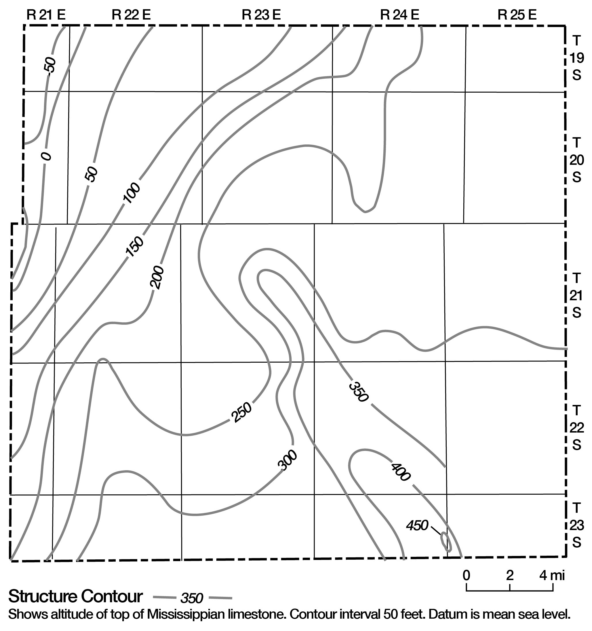
The sequence of Paleozoic rocks in Linn County has, on a number of occasions since its deposition, been deformed by tectonic events of regional and local magnitude. One of the earliest events, the pre-Mississippian uplift of the Ozark dome, established the northwest dip of the pre-Mississippian rocks in eastern Kansas and resulted in erosion of Middle Ordovician rocks in Linn County. Post-Mississippian subsidence in eastern Kansas and adjoining areas during the earliest period of Pennsylvanian deposition formed the Forest City basin, a basin marked by thickening of the Cherokee Group to the northwest in Linn County. The southern boundary of this basin, a positive structural element known as the Bourbon arch, underlies southernmost Linn County. The principal tectonic event in eastern Kansas, the post-Permian tilting of rocks to the northwest, known as the Prairie Plains monocline (homocline), established the present northwest dip in eastern Kansas. The structural configuration resulting from these events is shown in figures 4 and 5.
Figure 4--Configuration of base of Kansas City Group (interpolated from logs of oil and gas test wells).
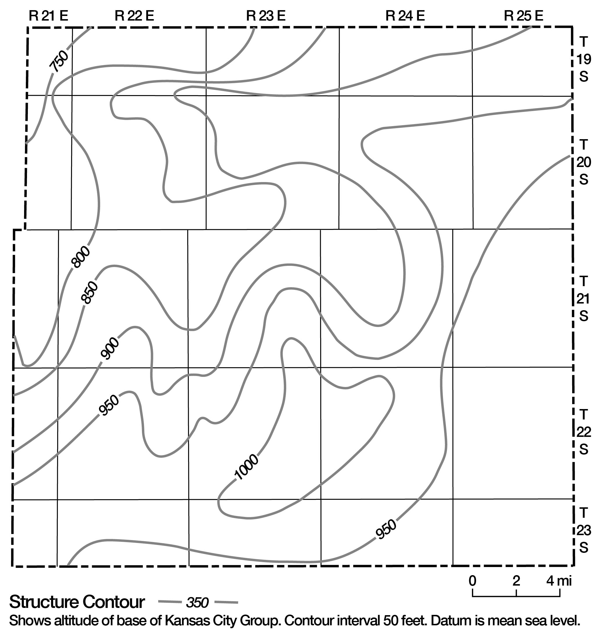
Figure 5--Configuration of upper surface of Mississippian limestone (interpolated from logs of oil and gas test wells).
Local
Several prominent domal structures and a number of local deformations related to compaction and possibly to collapse are observed in Linn County, and several have been mapped and described in detail. One domal structure, probably the largest, the Mound City dome (Jewett, 1949), was shown by Padgam (1957) to be a slightly elongated dome 1.5 miles in diameter located 1 mile northeast of Mound City. A number of smaller domes were noted by Padgam in this area and along the Kansas-Missouri boundary east of Pleasanton. Similar structures have also been noted in the vicinity of Trading Post and Prescott.
Anomalous dips and distortions in bedding noted in exposures of the Bandera Shale are normally directly underlain by flat-lying beds and are probably the result of compaction. Other peculiar structures include small-diameter chimney-like zones of brecciated Desmoinesian rock in the Pleasanton-Prescott area that are associated with lead and zinc mineralization (Schoewe, 1959), closed depressions or sink holes oA the upper surface of the Mississippian System near Pleasanton, and very steeply dipping beds of the Hepler Sandstone Member of the Seminole Formation noted just north of Pleasanton (Padgam, 1957). Because these structures are local and abrupt and occur above possible Mississippian solution features, it is suggested that they are related to these solution features.
Prev Page--Introduction || Next Page--Ground water
Kansas Geological Survey, Geology
Placed on web June 8, 2009; originally published November 1969.
Comments to webadmin@kgs.ku.edu
The URL for this page is http://www.kgs.ku.edu/General/Geology/Linn/03_geol.html