![]()
Prev Page--Contents || Next Page--Geologic units
Introduction
Purpose of Investigation
This study of the geology and ground water in Linn County is one in a series of county investigations conducted in Kansas to evaluate the quality and quantity of ground water and the geologic parameters which control the occurrence of ground water.
Cooperators in this project are the State Geological Survey of Kansas, the U.S. Geological Survey, the Environmental Health Services of the Kansas State Department of Health, and the Division of Water Resources of the Kansas State Board of Agriculture.
Location and Extent of Area
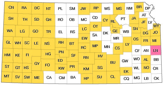
Linn County, located in east-central Kansas in the first tier of counties west of the Kansas-Missouri boundary, is bounded on the north by Miami County, on the south by Bourbon County, and on the west by Anderson County (fig. 1). Total area of the county is about 605 square miles.
Figure 1--Index map of Kansas showing area described in this report and areas covered by other online geologic reports, as of June 2009. For additional information, please visit the KGS Geologic Maps of Kansas Page.
Physiography
Linn County is located in the Osage Plains section of the Central Lowlands physiographic province (Fenneman, 1931). Schoewe (1949) includes this area in the Osage Cuestas of the Osage Plains.
In areas of Linn County directly underlain by bedrock of Pennsylvanian age, topographic form is a function of differential erosion of the various limestone, sandstone, and shale rock units. Four physiographic divisions, which correspond to the outcrop areas of the Marmaton Group; the Pleasanton Group; the Bronson, Linn, and Zahara Subgroups of the Kansas City Group; and the Lansing Group, are recognized and are shown on plate 1.
Drainage
The alluvial-filled valleys of the Marais des Cygnes River and its larger tributaries range from less than a mile to several miles in width in Linn County. The surface developed on these deposits is broad and featureless and is broken only locally by the erosional remnants of older alluvial deposits and by the scars of former meanders.
All but the southernmost tier of townships in the county are drained by the Marais des Cygnes River and its tributaries; the remaining area is drained by tributaries of the Little Osage River. The width of the Marais des Cygnes flood plain ranges from 1 to 6 miles and averages about 4 miles in Linn County. The width of the river channel averages about 200 feet. The gradient of the Marais des Cygnes River in Linn County is about 1.1 feet per mile.
Climate
The climate of Linn County is of the humid continental type and is favorable to the production of most of the crops grown in the State. The length of the growing season ranges from a minimum of 151 days to a maximum of 185 days; the average length is 181 days. The latest recorded date of a killing frost in the county was May 9th, and the earliest recorded date for a killing frost was September 9th.
Average temperatures at Mound City range from 31.7° F in January to 78.6° F in July, with an annual average of 56.3° F (based on the period 1931-60 from the U.S. Weather Bureau records).
Annual precipitation in Linn County averages about 39 inches (fig. 2, table 1) and increases very slightly from northwest to southeast. About 70 percent of the yearly precipitation occurs during the growing season (Furness, 1959, p. 41), and 95 percent occurs as rain.
Figure 2--Variation of annual precipitation in Linn County and adjoining areas.
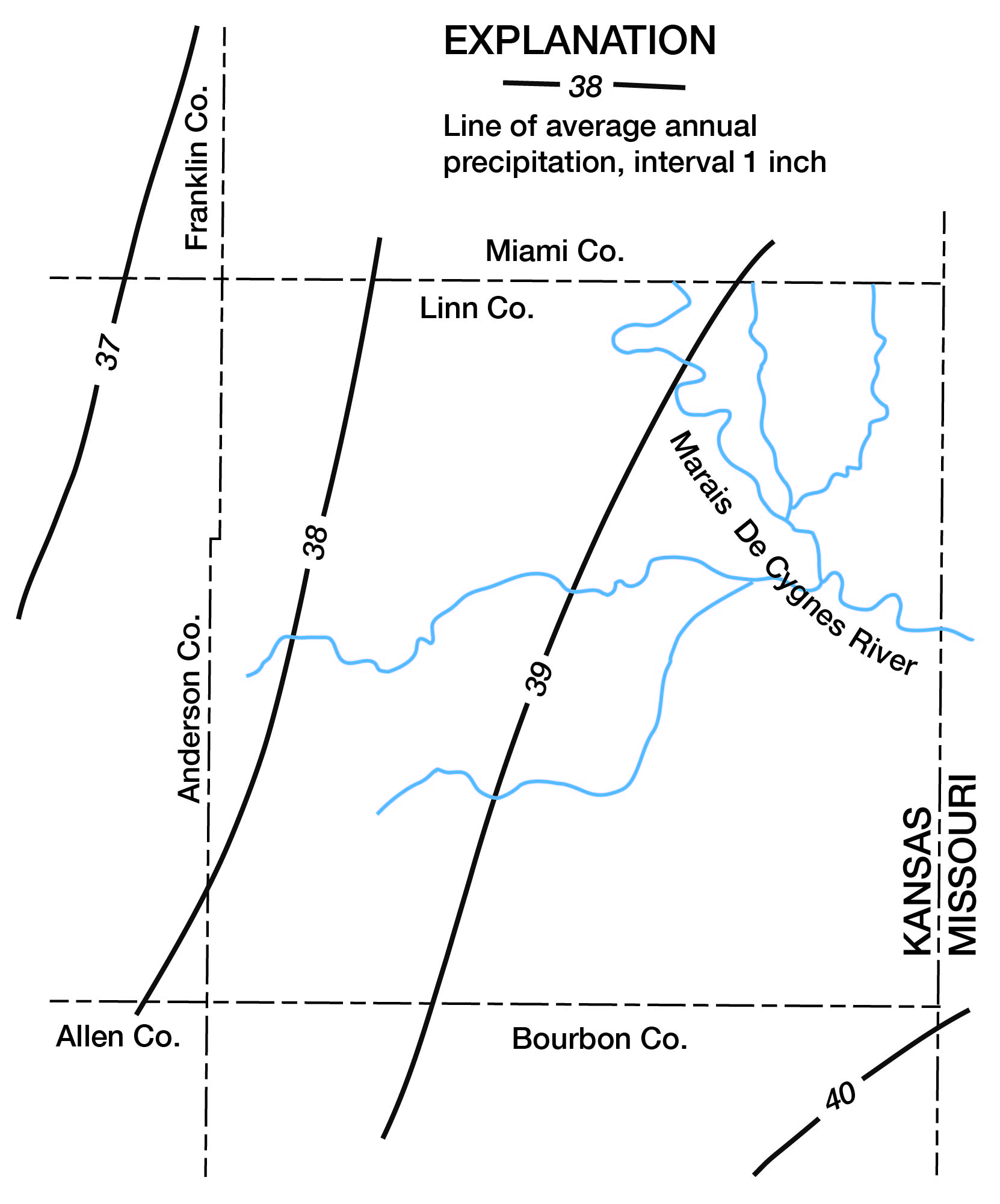
Table 1--Monthly normal precipitation at La Cygne, based on the period 1931-60 (from published records of the U.S. Weather Bureau).
| Month | Mean precipitation, inches |
|---|---|
| January | 1.52 |
| February | 1.43 |
| March | 2.59 |
| April | 3.76 |
| May | 5.28 |
| June | 5.46 |
| July | 4.73 |
| August | 3.55 |
| September | 4.40 |
| October | 3.04 |
| November | 2.12 |
| December | 1.52 |
| Annual | 39.40 |
Previous Investigations
Geological investigations in Linn County and adjacent areas in which the stratigraphy, structural geology, and economic geology have been discussed include reports by numerous geologists and scientists listed in the References in this report.
Methods of Investigation
Data on which this report is based were collected in the summer and fall of 1960 and 1961. A number of stratigraphic sections were studied and described, and the significant formational contacts were located in the field and traced on aerial photographs. Two hundred twenty-two water wells were inventoried (table 4), and water samples for chemical analysis were collected from 25 selected wells in the county (table 2).
Test holes were drilled with a power auger across the Marais des Cygnes and several larger tributary valleys and with a hydraulic rotary drill in the upland bedrock areas. Samples were collected from all test holes and filed in the well-sample library at Lawrence.
Geology and other data were mapped on aerial photographs obtained from the Production and Marketing Administration of the U.S. Department of Agriculture and on base maps obtained from the State Highway Commission of Kansas.
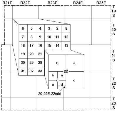
Well-Numbering System
In this report wells and test holes are located according to the General Land Office coordinating system. According to this system (fig. 3), the first three sets of numbers of the well number designate the township, range, and section, in that order. The letters which follow indicate the quarter section, the quarter-quarter section, and the quarter-quarter-quarter section. The quarter sections are lettered a, b, c, and d in counter-clockwise order starting in the northeast quadrant. When two or more wells or test holes are located within the same division, they are numbered serially in the order in which they were inventoried.
Figure 3--Well-numbering system used in this report.
Acknowledgments
The author is deeply indebted to Dr. J. M. Jewett, Senior Geologist of the State Geological Survey of Kansas, who gave so freely of his time and understanding of the Paleozoic rocks of Kansas. Appreciation is also expressed to the many residents of Linn County who supplied much of the basic data and to the well drillers in the area--especially Claude Crowder of Fort Scott, Roy Cook and Clarence Haynes of Pleasanton, and Mr. T. Nelson of La Cygne, who provided many logs from this area; Virgil Burgat and Frank Wilson of the State Highway Commission of Kansas, who provided geologic profiles along highways in Linn County; and Richard Gentile of the Missouri Geological Survey and Water Resources, who provided geologic information from adjacent areas in Missouri.
Prev Page--Contents || Next Page--Geologic units
Kansas Geological Survey, Geology
Placed on web June 8, 2009; originally published November 1969.
Comments to webadmin@kgs.ku.edu
The URL for this page is http://www.kgs.ku.edu/General/Geology/Linn/02_intro.html