![]()
Prev Page--Ground-water Resources, Chemical Character || Next Page--Utilization
Groundwater Resources, continued
Aquifer Properties
An aquifer is a geologic formation, a part of a formation, or a group of formations that will yield significant quantities of water to wells and springs. The properties of an aquifer that determine its capacity to transmit water and to release water from storage are its permeability, transmissibility, and storage. These factors depend in part on the thickness, extent, continuity, and homogeneity of an aquifer and on the size and nature of the pore spaces in the aquifer.
The field coefficient of permeability (P) is defined as the number of gallons of water per day, at the prevailing water temperature, that will move in 1 day through a vertical section of the aquifer 1 foot square under a hydraulic gradient of 100 percent or 1 foot per foot (Stearns, 1928). Coefficients of permeability of less than 100 gpd (gallons per day) per sq ft (square foot) are considered low, coefficients of 100 to 1,000 are medium, and those of more than 1,000 are Considered high. The coefficient of transmissibility (T) is equal to the field coefficient of permeability multiplied by the saturated thickness (in), in feet, of the aquifer (Theis, 1935, p. 520).
The coefficient of storage (S) is defined as the volume of water, measured in cubic feet, released from storage in each column of the aquifer having a base 1 foot square and a height equal to the thickness of the aquifer, when the water table or other piezometric surface is lowered 1 foot. In water-table aquifers the coefficient of storage for long periods of pumping is approximately equal to the specific yield and has a range of about 0.1 to 0.3. The specific yield is defined as the ratio of the volume of water a saturated material will yield by gravity to its own volume. For artesian aquifers the coefficient of storage generally is very small, ranging from about 10-5 to 10-3 g.
Drawdown in a well is the lowering of the water table by pumping or of the piezometric surface by artesian flow. The specific capacity of a well is the discharge expressed as rate of yield per unit of drawdown, generally gallons per minute (gpm) per foot of drawdown. Specific capacity is a better measure of an aquifer's capacity to yield water than is the actual yield of a well, because it relates yield to drawdown in the well.
Hydrologic data for aquifers in Johnson County and the source of the data are summarized in table 8. The availability of groundwater in the unconsolidated and consolidated rock aquifers and the important aquifer properties known or inferred are described in the following pages.
Availability of Groundwater
Ground water for stock and domestic purposes may be obtained in Johnson County from unconsolidated Pleistocene rocks locally to a maximum depth below land surface of about 70 to 100 feet and in consolidated Pennsylvanian rocks locally to a depth of about 250 feet.
The Pleistocene aquifers are all unconsolidated, except for parts of some Kansan glaciofluvial deposits that are cemented with calcium carbonate. Pleistocene aquifers have a wide range of geologic and hydrologic characteristics and occur beneath the upland areas, beneath terraces, and as valley fillings. The texture of the deposits ranges from well-sorted sand and gravel to unsorted boulder clay. Yields from wells drilled into the unconsolidated deposits range from zero, where the deposits are thin and do not contain a saturated zone, to more than 1,000 gpm in the Kansas River valley alluvium.
The consolidated Pennsylvanian rock aquifers that contain groundwater of suitable quality for livestock or domestic use consist chiefly of limestone and shale, together with a minor amount of fine-grained sandstone. Yields of wells drilled into the Pennsylvanian rocks cannot be accurately predicted, but generally are less than 50 gpm. Probably 90 percent or more of the wells drilled in consolidated rocks have sustained yields less than 10 gpm, and 50 percent or more of the wells probably have sustained yields less than 3 gpm. An estimate of well yield at a particular site can be made from the records of nearby wells listed in table 10 (p. 54), which contains information about 139 wells, test holes, and springs in Johnson County.
Unconsolidated Rock Aquifers
The principal unconsolidated rock aquifers in Johnson County are shown on the geologic map (pl. 1) as alluvium (Qal), Newman terrace deposits (Qtn), and undifferentiated fluvial deposits in tributary valleys (Qtu).
Kansan fluvial and lacustrine deposits (Qd) yield small supplies of ground water locally in northwestern Johnson County and near Holliday.
In addition to the unconsolidated rock aquifers described above and shown on the geologic map, there are unmapped deposits of residuum that cover much of the upland interstream areas and locally derived colluvium that occurs along the sides of many intermittent stream valleys. These deposits are locally 20 feet or more thick and are the chief aquifer for many of the older large-diameter stock and domestic dug wells.
Kansas River Valley Alluvium
Large quantities of ground water are available from wells in the alluvium in the Kansas River valley. The extent of the alluvium is shown on plate 1. Logs of wells and test holes (at the end of this report) indicate that the alluvium has a thickness of about 40 to 70 feet. The thickness of saturated water-bearing material ranges from about 30 to 60 feet, but commonly is 35 to 40 feet. The average hydraulic gradient of the water table in this part of the Kansas River valley is about 2.5 feet per mile (Dufford, 1958, fig. 3). The specific capacities of alluvial wells reported in table 8 range from 14 to 116 gpm per ft of drawdown and probably are representative of specific capacities for alluvial wells in Johnson County. However, the specific capacities are less than those reported for alluvial wells in adjacent Douglas County.
Permeability and transmissibility values for alluvium in this part of the Kansas River valley have not been determined by aquifer tests, but they are probably similar to values obtained in adjacent parts of the valley in Douglas County. Most of the alluvium in Douglas County has a permeability of 1,000 gpd per sq ft or more and, in places, a permeability greater than 12,000 gpd per sq ft (Lohman, 1941, p. 36; O'Connor, 1960, table 6). Coefficients of transmissibility of the aquifer in Johnson County, inferred from similarities of geology and hydrology in Douglas County and the specific capacities of inventoried wells, are estimated to range from about 30,000 to 200,000 gpd per ft. Yields of wells in the alluvium generally range from 150 to 1,000 gpm, and yields of more than 1,000 gpm are probably obtainable.
Industrial and municipal pumping in the Kansas River valley alluvium is chiefly in the vicinity of DeSoto and Cedar.
The water table in the Kansas River valley, at distances more than about 0.5 mile from the river and in areas not affected by industrial, irrigation, or municipal pumping, may fluctuate as much as 15 to 20 feet through a cycle of wet and dry years. This fluctuation is an important factor to consider in planning large-capacity wells to ensure that the capacity of a pump and the design of a well correspond to the capacity of the aquifer to yield water in periods of both high and low water-table conditions. The water-level fluctuations in four observation wells near Cedar and Wilder (pl. 1) are shown graphically on figure 16. Only one of the three observation wells in the valley near Wilder is noticeably affected by river stage. Observation well 11-23E-33bba is on the south bank of the Kansas River and, depending on the stage of the river, is about 50 to 300 feet from the river's edge. Records of wells and test holes in this aquifer are given in table 10.
Figure 16--Hydrographs for four selected wells.
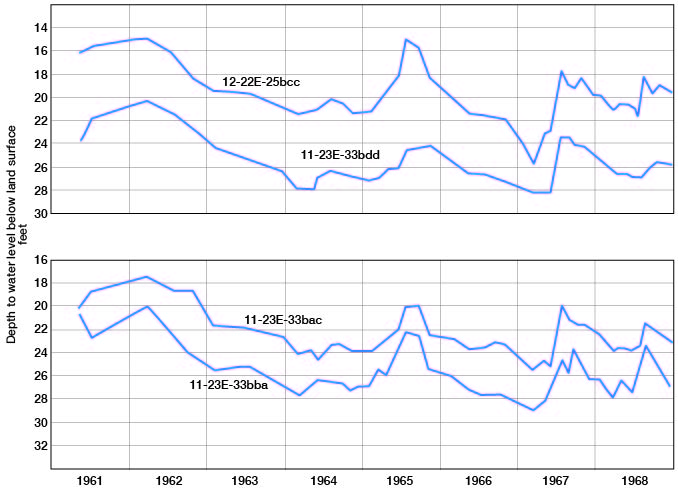
The chemical character of ground water in the aquifer is indicated by the water analyses in table 4. In general, the groundwater can be characterized as a very hard calcium bicarbonate water that generally contains much iron. A few wells pump ground water having less than 0.1 mg/l iron.
Tributary Valley Alluvium of the Kansas, Missouri, and Marais des Cygnes Rivers
Only small quantities of ground water are available from wells in the alluvial deposits (pl. 1) in the tributary valleys of the Kansas, Missouri, and Marais des Cygnes Rivers. The alluvial material in these valleys ranges in thickness from about 20 to 75 feet in the lower reaches of the larger tributaries, but commonly is only 10 to 30 feet thick in the upper reaches. In the thicker alluvial deposits the saturated thickness of the alluvium may be as much as 60 feet thick.
The water-bearing material in these valleys is derived chiefly from rocks in the drainage area of the individual tributary. Because of the large amount of shale in the area and the thin loess deposits on the uplands, most of the valley-fill sediments are clays and silts. The coarse fraction of the alluvium is chiefly poorly sorted limestone and chert gravel in a silt or clay matrix. Captain Creek and Spoon Creek, which drain areas of the Ireland Sandstone Member of the Lawrence Formation and areas of extensive sandy glaciofluvial deposits, are exceptions, and the alluvial deposits of these streams locally are sandy.
Because the aquifers in most tributary valleys are composed predominantly of silt and clay, the transmissibilities are low. Well yields of 25 to 100 gpm probably can be obtained in the lower part of Cedar Creek valley and in parts of Captain Creek valley; however, in 1960 there were no wells of this capacity in operation. Yields of 1 to 10 gpm are more representative of wells in most of the tributary valleys.
Because of low aquifer transmissibility and low well yields, large-diameter dug wells that provide considerable storage in the well itself have been more satisfactory than small-diameter drilled wells. Well 15-22E-5ddd along Bull Creek (tables 4, 10) is representative of the water supplies available from these deposits.
The chemical quality of ground water from deposits in tributary valleys generally is satisfactory for domestic and stock use. However, some of the water is hard and, in some instances, contains high concentrations of iron (table 4).
Kansan Deposits
Kansan deposits, exclusive of those that may be present in the Kansas River valley, are significant sources of groundwater in only two relatively small areas. The larger of these areas is west of Kill Creek and extends south of the Kansas River valley for about 10 miles (pl. 1). The area is an eastward continuation of extensive Kansan deposits in the Hesper vicinity of Douglas County. The Kansan deposits along the Douglas County-Johnson County boundary are as much as 52 feet thick (test hole 13-21E-26ccd2) and consist of outwash, lacustrine deposits, and till. The basal part of the deposits commonly is sand, or sand and gravel. Except where the deposits have been dissected and removed by post-Kansan stream erosion, or where the deposits are thin, they generally contain a thin saturated zone that yields water readily. Wells yielding 50 to 100 gpm probably can be obtained from Kansan deposits in parts of this area, although no wells with yields this large were inventoried. Several test holes that were drilled during this investigation penetrated 10 to 20 feet of saturated sand and gravel. Other test holes, however, penetrated little or no sand (12-22E-31dcb), or have little or no water-bearing material (13-21E-2abb). Because of the wide range in the lithology and saturated thickness of the Kansan deposits, the amount of groundwater obtained from wells varies greatly from one locality to another.
Although no aquifer tests were made, some of the Kansan deposits consist of well-sorted sand and gravel that probably have permeabilities greater than 1,000 gpd per sq ft. Conversely, the deposits of sandy clay that comprise parts of the aquifer probably have very low permeabilities.
Most of the ground water is discharged naturally from the aquifer through springs and seeps. Captain Creek and some of its small tributaries have perennial flow maintained by ground-water discharge from the Kansan deposits.
The second area in which Kansan deposits are significant as an aquifer is south of the Kansas River near Wilder, bounded on the east by Mill Creek and on the south by Clear Creek (pl. 1). In this area, the deposits are similar in character to those previously described west of Kill Creek, but they probably have a greater range in thickness. Jewett and Williams (1935, p. 198) reported about 80 feet of drift in this area, and Newell (1935, p. 83) subsequently measured and described about 71 feet of Kansan deposits that consist mostly of sand and gravel and locally contain zones of cemented conglomerate. Dufford (1958, p. 46) reported more than 100 feet of glacial outwash in the area. The thickness of the deposits reported by Newell (1935) in the vicinity of the Ahlskog gravel pit (NE cor. sec. 11, T. 12 S., R. 23 E.) and the altitude of the water table in the pit indicate that locally there are 50 feet or more of saturated Kansan deposits consisting of sand and gravel. Jewett and Williams (1935) reported that a spring flowed about 60 gpm from the lower part of the aquifer. According to J.M. Jewett (oral commun., 1964) the spring is north of the Ahlskog pit in the SW 1/4 sec. 2, T. 12 S., R. 23 E.
Yields of 50 gpm or more probably could be obtained from wells completed in these deposits, but no wells were inventoried that had yields of this magnitude. Because most of the deposits consist of sandy silts or silty sand, wells completed in these materials have small yields. Along the outcrop margins, the Kansan deposits yield little or no water to wells, because they are drained or are thin with an intermittent saturated zone.
The chemical quality of ground water from wells in Kansan deposits is indicated by the analyses in table 4. The water can be characterized as hard to very hard calcium bicarbonate water that contains high concentrations of iron. The water is satisfactory for most domestic uses except for its hardness and iron content.
Other Aquifers
Much of the upland and slope area of Johnson County is covered by relatively thin but areally extensive deposits of weathered surficial material that overlies the Pennsylvanian bedrock. This material includes unmapped colluvium, slopewash, residual soil, and, in much of the upland area, a thin cap of loess. Collectively these deposits comprise the regolith, or mantle rock, and are of hydrologic importance in two respects: as a source locally of very small domestic and stock water supplies, and as the surficial material through which much of the recharge to the underlying limestone, sandstone, and shale must move.
In addition to the regolith, thin, narrow patches of fluvial deposits in the upland and slope areas locally yield ground water to wells along the tributary streams. The fluvial deposits shown on plate 1 are arbitrarily terminated along the headward parts of the streams. However, there are patches of thin water-yielding fluvial deposits of variable thickness and width along the streams beyond the mapped deposits. Because groundwater moves from the superjacent interstream areas toward the streams, these thin fluvial deposits frequently receive seepage from adjacent bedrock and, in wet years, from the regolith.
Consolidated Rock Aquifers
The consolidated rock, or bedrock, aquifers are the limestones, sandstones, and shales of Pennsylvanian and older age that underlie Johnson County. The chemical quality of ground water pumped by domestic and stock wells from bedrock aquifers ranges from excellent to poor. Many of the bedrock wells yield water that is more mineralized than groundwater pumped from the unconsolidated Pleistocene deposits. Wells obtain fresh or slightly saline water (table 7) at depths of 100 feet or less, and no area of the county is known where fresh or slightly saline water occurs at depths greater than about 250 feet. Locally, groundwater at depths of less than 100 feet is moderately saline. Groundwater from Pleasanton Group and older rocks is believed to have more than 10,000 mg/l dissolved solids throughout Johnson County.
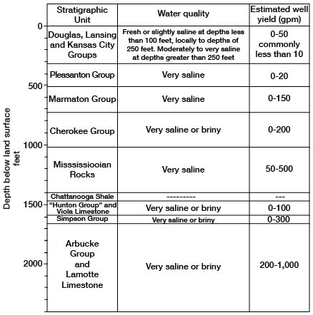
The yields of wells in the bedrock aquifers generally are less than 10 gpm. A few wells have yields of 10 to 50 gpm, but these are restricted chiefly to areas where the Wyandotte Limestone has greater than average permeability and to part of the area underlain by the Ireland Sandstone Member of the Lawrence Formation. The water-bearing characteristics of Pennsylvanian and older rocks in Johnson County are summarized in figure 17.
Figure 17--Water-bearing characteristics of Pennsylvanian and older rocks.
Shale Aquifers
The shales in Johnson County that contain fresh to moderately saline water probably have porosities that range from 5 to 20 percent (Hedberg, 1926; Athy, 1930). The shales have such extremely low coefficients of permeability that, for practical purposes, they will not yield water to wells. There are two exceptions to this general statement.
The first group of shales that may be considered as aquifers is the black or very dark gray fissile shales that comprise parts of the Hushpuckney, Stark, Muncie Creek, and Eudora Shale Members and, locally, the Quivira. These black shales have nearly vertical open fractures that have been developed partly by shrinkage of colloidal material in the black sediments and partly by deep-seated stresses. Wells that intersect these open fractures obtain small supplies of water. The Stark Shale Member of the Dennis Limestone and the Hushpuckney Shale Member of the Swope Limestone yield fresh to slightly saline water to wells in eastern Johnson County in most of R. 25 E.; in parts of T. 12 S. the water is moderately saline. Six wells in these shales in R. 25 E. have yields ranging from about 0.5 to 5 gpm. An analysis (table 4) of a water sample from well 14-25E-22baa, completed in the Stark Shale Member at a depth of 200 feet, indicates that the water is a very soft (hardness, 14 mg/l) sodium bicarbonate type, is high in fluoride concentration (14 mg/l), and has a dissolved-solids concentration of about 1,300 mg/l. The water would be classified as slightly saline and would be usable for livestock. However, in spite of its undesirably high dissolved-solids and fluoride content, the water is used for domestic purposes. The Earl Caddell well (12-25E-35bbd) is reported to yield 3 gpm of good-tasting "fresh" water from the Stark Shale Member at a depth of 127 to 131 feet. Other wells in the Stark and Hushpuckney are reported to obtain water ranging in quality from fresh to slightly saline, which is used for stock and domestic water supplies. Elsewhere in central and western Johnson County at depths of 200 to 400 feet, water in the black shales in the lower part of the Kansas City Group is believed to be moderately saline to very saline (12-24E-4dad, 12-24E-4ddc, table 9).
About 10 to 20 percent of the drillers' logs of wells drilled in central and western Johnson County note "salty" water in the lower Kansas City Group black shales, generally in amounts less than 20 gpm.
Locally black shale in the Quivira Shale Member of the Cherryvale Shale yields very small amounts of fresh to slightly saline water to wells at depths of 250 feet or less.
The Muncie Creek Shale Member of the Iola Limestone includes 1 to 2 feet of black shale in the northwest and north-central parts of the county. This black shale yields small quantities of fresh to slightly saline water to a few wells. Well 13-21E-3ddd, in adjacent Douglas County about 150 feet west of the Johnson County-Douglas County boundary, yields 35 gph (gallons per hour) from the Muncie Creek at a depth of 198 to 200 feet. The water is slightly saline but, because water of better quality is not available, it is used as a domestic supply.
The second group of shales that may be considered as aquifers is the near-surface shales in the zone of weathering. Various weathering processes and biological activities tend to enlarge and increase the number of secondary openings in the shales. As a result, the shale beds at or near land surface have a much greater permeability than do similar shale beds at depths of 50 feet or greater. Many of the shale beds will yield a few hundred gallons of water per day to large-diameter (greater than 3 feet) wells that intersect one or more fractures or other openings. Fractures in the shale decrease in size and number downward, and, except in the black fissile shales, are few below depths of about 50 feet.
Limestone Aquifers
Most of the limestones that are within the zone of fresh to slightly saline water are relatively uniform in thickness and composition, are laterally continuous, and are nearly flat lying. Except where weathered, they are relatively impermeable and generally yield little or no water to wells. At or near band surface, however, weathering processes have increased and enlarged the interconnected open spaces within the rocks, especially along joints, fractures, and within any zones that originally had a significant primary permeability. The carbonate rocks are especially susceptible to solution in the vadose water zone, within the zone of fluctuation of the water table, and just above less permeable strata, such as shale beds, within the zone of saturation. Much of the fresh or slightly saline water obtained from wells in limestones in Johnson County is obtained from widely spaced solution-enlarged fractures at relatively shallow depths (less than 100 feet), but some of the wells may obtain water from limestones at depths as great as 240 feet.
Wyandotte Limestone--The Wyandotte is the most important limestone aquifer in Johnson County, but wells tapping this aquifer have a great range in yields. The largest well yield reported during this investigation was about 40 gpm (Marvin Rankin No. 1 gas well, NW SW sec. 9, T. 14 S., R. 22 E.). The Wyandotte is 74 feet thick at this location, and the permeable zone that yielded fresh water was found at a depth of 163 feet in the lower part of the formation. There apparently is a zone of significant solution permeability in the Wyandotte in this general area inasmuch as many oil and gas wells have found ground water in amounts sufficient for stock or domestic supplies.
The Wyandotte is more likely to yield water from fractures or solution cavities in those areas where the thickness of the formation is greatest (areas A and B, fig. 7). In areas where the Wyandotte is overlain by younger Pennsylvanian strata, the ground water generally is under artesian pressure and will rise in a well some distance above the point at which it was encountered.
Numerous springs discharge from the Wyandotte in southeastern Johnson County (area B, fig. 7). One of the larger springs (15-25E-4bab) was estimated to flow 100 gpm from a solution cavern near the base of the formation. This spring, and several others in this area, becomes turbid after heavy rains due to the flushing of the solution-enlarged joints, solution galleries, and sink holes through which surface water may enter and move through the formation.
Wells in the Wyandotte that do not penetrate saturated cavernous zones or open fractures yield little or no water. It is not unusual to have one well in this aquifer yield enough water for a small domestic supply and a nearby well, penetrating the same sequence and thickness of rocks, yield so little water that it is considered a "dry hole," the differences in yields being due to the size and number of fracture or solution openings penetrated in the zone of saturation by the well. About half of the wells drilled into this aquifer have yields of 0.5 gpm or more, but the range in yields is from 0 to 40 gpm. The localized character of the permeable zones is illustrated by the groundwater discharge and ice formation on a quarry face during wintertime (fig. 8B). The yield of many Wyandotte and other limestone aquifer wells probably could be increased appreciably by pressure acidization, but this method of stimulation, or development, has been utilized very little by the local drillers.
The chemical quality of groundwater from the Wyandotte at depths of 200 feet or less is variable, but generally the water can be characterized as a very hard calcium bicarbonate type that is satisfactory for domestic water supplies (13-22E-33ddd, 15-25E-4bab, table 4). The chemical quality may be poor (slightly to moderately saline) and yields may be very low at depths of 115 feet or less where the formation has little solution or fracture permeability and groundwater circulation is poor (12-23E-27bcb, 14-23E-11bcc2, tables 4 and 10). At depths greater than about 200 feet any groundwater obtained from the Wyandotte is likely to be moderately saline to very saline.
Other limestones--All the limestones that crop out in Johnson County have, at one place or another, open fractures, joints, and bedding planes that yield groundwater to shallow wells in the zone of weathering. Below a depth of 30 to 50 feet, however, few of the limestones have adequate permeability to be considered significant aquifers. Wells in the shallow limestone aquifers may go dry in drought years.
The chemical quality of water from the limestones generally is satisfactory for domestic use, except for excessive hardness and possibly high concentrations of iron. The sanitary quality of groundwater from shallow wells in the limestones may be poor; it should be tested regularly because many such wells are not properly constructed and are near sources of pollution. Testing of the water will be performed at little or no cost to the owner by the Division of Environmental Health of the Kansas State Department of Health. The local County Health Officer can explain the procedure.
Sandstone Aquifers
Several of the shale and limestone formations include thin beds of sandstone that locally yield water to wells. Stratigraphic units that contain sandstone beds are the Cherryvale, Chanute, Lane, Bonner Springs, and Vilas Shales, the Lawrence Formation, and the Rock Lake Shale Member of the Stanton Limestone. Sandstones in each of these units yield water to domestic and stock wells somewhere in the county. Except for the Ireland Sandstone Member of the Lawrence Formation, no sandstones are thick or permeable enough to yield more than about 5 gpm to wells. Many wells, in which 1 to 25 feet of sandstone was indicated by the driller's log, have reported yields of as much as 3 gpm. Numerous well logs report so little water that the sandstones are considered "dry." These "dry sandstones" may be siltstone, cemented sandstone, or impure shaly sandstone with very low permeability.
The sandstones in the Kansas City and Lansing Groups are chiefly very fine grained, micaceous, and quartzose, and have permeabilities generally less than 100 gpd per sq ft. The Lawrence Formation contains very fine to medium-grained quartzose micaceous sandstone that may range in permeability from 200 to 400 gpd per sq ft locally.
Sandstone identified as the "Belton sand" by Clair (1943, p. 20 and pl. 1) is considered to replace stratigraphically the Westerville Limestone Member of the Cherryvale Shale and all or parts of the underlying Wea Shale Member and overlying Quivira Shale Member in a part of Cass County, Mo., just east of the area between Stilwell and Stanley, Kans. Clair reports that the sand is as much as 34 feet thick, light gray, and quartzose to micaceous in character in the Belton area where the town of Belton has municipal wells that obtain water from this sandstone. Clair's studies indicate that the sands are narrow elongate bodies that trend southwesterly, have convex upper surfaces, and probably represent "offshore bar" type deposits. In southeastern Johnson County a few wells obtain fresh to slightly saline water, thought to come from sandstone in the stratigraphic position of the "Belton sand." The sandstone is believed to be restricted to southeastern Johnson County, chiefly in parts of Tps. 14 and 15 S., and probably only in a part of this area does the sandstone yield water suitable for domestic and stock supplies. Well 14-24E-32ccc is reported to yield about 150 gpd from 8 feet of sand in the Quivira or Westerville, which probably is equivalent to Clair's "Belton sand." The water is reportedly too mineralized for domestic drinking but is satisfactory for livestock use.
The Chanute Shale contains about 4 feet of very fine grained micaceous sandstone in eastern Johnson County, and, even where the sandstone is absent, the interval commonly is represented by sandy and silty shale. Groundwater from wells in the Chanute generally is hard, but is satisfactory for domestic use. In northwestern Johnson County, well 12-21E-36ccc yields about 3 gpm of moderately saline water (table 4) from depths of 207 to 216 and 220 to 236 feet, which are intervals of gray sandy shale and sandstone. The water from this well can be characterized as a sodium chloride type that is hard and contains a high concentration of fluoride. The water is used for livestock and domestic purposes other than drinking. Except for a few wells in the eastern part of the county, sandstone beds in the Chanute yield water that is too poor in quality for any use.
The Lane Shale contains sandstone and sandy shale beds in areas where the formation is thick. Well 15-23E-18ccc is 157 feet deep and is reported to yield about 100 gph from 12 feet of sandstone at a depth of 114 to 126 feet. The owner reports that this water is used for domestic and livestock purposes, is "soft," and has a slight "sodium bicarbonate taste." Only a few wells obtain water from sandstone in the Lane Shale in Johnson County.
Sandstone in the Bonner Springs Shale probably is more widely distributed in the county than any of the other sandstone aquifers described, and, locally, it is the principal aquifer in the southeastern part of the county. In parts of Tps. 13, 14, and 15 S., Rs. 24 and 25 E., the sandstone is 15 to 25 feet thick and yields fresh water supplies of 1 to 3 gpm from depths of 100 feet or less. In parts of the county groundwater from Bonner Springs sandstone may be slightly saline (well 14-23E-15daa, table 4) at depths of less than 100 feet.
Although the Vilas Shale locally includes as much as 11 feet of very fine grained sandstone and siltstone, very few wells obtain water supplies from the unit. Most of the wells in the Vilas have low yields, are shallow, and have large diameters.
The Rock Lake Shale Member of the Stanton Limestone generally contains 5 to 10 feet of very fine to fine-grained micaceous sandstone. Shallow wells tapping the sandstone at several localities in Johnson County commonly yield from 20 to 300 gph. Chemical analyses of water from two wells indicate that the water is a very hard calcium bicarbonate type (table 4).
The Lawrence Formation, which contains the Ireland Sandstone Member, yields water of good quality to stock and domestic wells in part of southwestern Johnson County and formerly was the source of water supplies for the towns of Gardner and Edgerton.
Pre-Kansas City Group Aquifers
Rocks older than those of the Kansas City Group in Johnson County are not known to contain water having less than 10,000 mg/l dissolved solids; therefore, pre-Kansas City Group aquifers have not been utilized for any domestic, stock, industrial, or irrigation purposes. Figure 17 shows the quality of groundwater and estimated yield that are obtainable from Pennsylvanian and older rocks in Johnson County. Analyses of water samples from several oil and gas wells are given in table 9.
Prev Page--Ground-water Resources, Chemical Character || Next Page--Utilization
Kansas Geological Survey, Johnson County Geohydrology
Web version April 2002. Original publication date Dec. 1971.
Comments to webadmin@kgs.ku.edu
The URL for this page is http://www.kgs.ku.edu/General/Geology/Johnson/07_gw3.html