![]()
Prev Page--Introduction || Next Page--Subsurface Rocks
Geography
Topography and Drainage
Johnson County lies partly within the Attenuated Drift Border division of the Dissected Till Plains and partly in the Osage Cuestas division of the Osage Plains (Schoewe, 1949). Much of the area consists of gently rolling uplands with hilly areas along the streams. North-flowing streams tributary to the Kansas River, such as Kill Creek, Cedar Creek, Mill Creek, have steeper gradients and greater local relief than east-flowing and south-flowing streams. Relief of 150 to 250 feet is common within a mile of the north-flowing streams in their more hilly parts. Local relief along the east-flowing tributaries of the Missouri River and the south-flowing tributaries of the Marais des Cygnes River within a mile of the stream generally is less than 150 feet.
The flood plain ranges from about 0.2 to 0.5 mile in width along the principal streams, except along the Kansas River where it ranges from 1 to 2 miles in width.
The highest point in the county, about 1,134 feet above mean sea level, is in the southeastern part (secs. 17 and 18, T. 15 S., R. 25 E., Bucyrus topographic quadrangle) and the lowest point, about 742 feet, is along the Kansas River where the river flows eastward into Wyandotte County. Maximum relief in the county is about 392 feet.
Climate
According to the U.S. Weather Bureau (Flora, 1948) Johnson County has a modified humid continental climate. It has higher precipitation, a higher relative humidity, less sunshine, and less range between day and night temperatures than counties in central and western Kansas, Winters are milder and the growing season is longer than areas to the west and north. Average midday and early evening relative humidities in eastern Kansas in July range from 45 to 50 percent. In the winter relative humidities average somewhat higher, often to nearly 70 percent.
The average date of the last killing frost in spring is April 17 (Flora, 1948, p. 223), and the average date of the first killing frost in the fall is October 18. Nearly 75 percent of the annual precipitation occurs during the growing season, which averages 184 days.
The mean monthly and mean annual precipitation and temperature at Olathe are given in table 1.
Table 1--Mean monthly and mean annual precipitation and termperature at Olathe, 1931-55 (from records of U.S. Weather Bureau).
| Month | Mean Precipitation (inches) | Mean Temperature (deg F) |
|---|---|---|
| January | 1.35 | 30.6 |
| February | 1.25 | 34.7 |
| March | 2.11 | 44.3 |
| April | 3.79 | 55 |
| May | 5.29 | 64.2 |
| June | 5.08 | 74.5 |
| July | 3.34 | 79.6 |
| August | 4.06 | 78.1 |
| September | 3.63 | 70.2 |
| October | 2.68 | 59.6 |
| November | 1.93 | 43.8 |
| December | 1.48 | 34.1 |
| Mean Annual, 1931-55 |
35.99 | 55.7 |
Population
Johnson County, one of the original territorial counties, was organized in 1855. In 1970 it ranked second among the counties of the State, having a population of 217,662 (U.S. Bureau of the Census, 1971). The northeastern fourth of the county is urban and includes more than a dozen cities and villages. The five largest incorporated areas and their 1970 populations are: Overland Park, 76,623; Prairie Village, 28,138; Shawnee, 20,482; Olathe, the county seat, 17,917; and Merriam, 10,851.
Agriculture and Industry
Livestock and poultry having a value of $5,072,640 and crops having a value of $5,209,230 were produced in 1969 on Johnson County farms. According to the 1964 census there were 1,041 farms (Kansas State Board of Agriculture, 1971). The acreage amid value of principal crops grown in Johnson County in 1969 are shown in table 2.
Table 2--Acreage and value of principal crops grown in 1969 (Kansas State Board of Agriculture, 1971).
| Crop | Acres Harvested | Value |
|---|---|---|
| Wheat | 14,000 | $500,000 |
| Corn, all purpose | 26,730 | 1,943,500 |
| Oats | 1,560 | 42,100 |
| Barley | 120 | 4,100 |
| All sorghum, for grain |
13,500 | 918,000 |
| All sorghum, for forage |
100 | 3,800 |
| All sorghum, for silage |
400 | 37,400 |
| Soybeans | 14,800 | 814,000 |
| All hay and pasture |
22,800 | 898,600 |
| Alfalfa hay | 5,800 | 353,200 |
| Wild hay | 3,000 | 79,200 |
| Other crops | 640 | 47,730 |
| Total | 94,650 | $5,209,230 |
Most of the industries in Johnson County are relatively small. The Sunflower Army Ammunition Plant at DeSoto formerly was the largest industry in terms of employment, but the plant was inactive in 1964. It was reactivated in 1966 and again is one of the largest industries in tennis of employment. Manufacturing industries in 1959 included metal fabrication and welding, tool and die manufacture, sulfuric acid manufacture, pharmaceutical and veterinary supplies, farm machinery and feed milling equipment, feed and commercial fertilizer manufacture printing and publishing, cabinet, manufacture, storage batteries, boots and shoes, apparel, furniture, and greeting card manufacture (Kansas State Department of Economic Development, 1963).
Mineral Resources
The U.S. Bureau of Mines (1968) lists oil and gas, sand and gravel and limestone, having a value of $2,312,252, as minerals produced commercially in Johnson County in 1966.
Oil and Gas
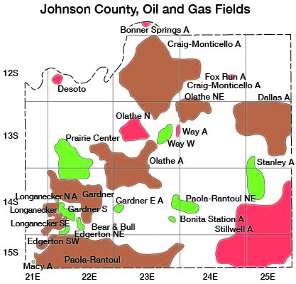
The Nomenclature Committee of the Kansas Geological Society has designated 10 named areas of oil and gas production in Johnson County--two which have produced oil and gas and eight which have produced gas only (fig. 3). Several of the gas fields are abandoned or produce noncommercial amounts of gas. Oil and gas have been produced from Pennsylvanian sandstone in the Marmaton Group and from the "Squirrel sandstone" and "Bartlesville sandstone" in the Cherokee Group. Gas production has been reported from the "Knobtown sandstone" in the upper pant and from a sandstone in the lower part of the Pleasanton Group (Jewett, 1954).
Figure 3--Map of Johnson County showing oil and gas fields. Other information is available online on the Survey's Johnson County page.
![]()
The Cities Service Gas Co. is utilizing the Craig (Craig-Monticello) field for the underground storage of natural gas. Gas is stored at an average depth of 582 feet in the "Bush City sandstone" or "Squirrel sandstone" in the upper part of the Cherokee Group. In 1966 there were 61 storage wells in operation. Storage capacity of the field is: reported to be 6,075,820 mcf (thousand cubic feet) [gas volume computed at 14.65 psia (pounds per square inch, absolute), temperature 60 deg. F] at 205 psig (pounds per square inch, gage) at the wellhead (M.O. Oros, written commun., 1967).
In 1966 the Dallas field produced 75 barrels of oil from 1 well, the Gardner field produced 38,861 barrels from 63 wells, and 1 other well produced 40 barrels. Gas production was estimated to be 280,000 mcf from two wells in the Gardner Reid and 228,350 mcf from an estimated 53 wells in other parts of the county. An estimated 10 new oil and gas wells and dry holes were drilled in 1966 (Oros and Beene, 1968).
Sand and Gravel
Building and paving sand, fill sand, filtration sand, and building gravel are produced by Builders Sand Co. and the Holliday Sand and Gravel Co. (Hardy and Hornbaker, 1968). All the sand and gravel is dredged from the Kansas River or from pits in Kansas River valley alluvium.
Limestone
Limestone is the most important mineral resource in terms of dollar value and the Wyandotte Limestone is the most important geologic unit in Johnson County. The county ranked first in value of stone produced in Kansas in 1966. According to A.L. Hornbaker (oral commun., 1967) Reno Construction Co., Union Quarries, Inc., and Deitz-Hill Development Co. produced 1,430,000 short tons of crushed limestone for concrete aggregate, roadstone, and agstone (agricultural limestone) having a value of $1,827,000 in 1966. The principal stratigraphic units quarried commercially for concrete aggregate, roadstone, and agstone are the Argentine and Farley Limestone Members of the Wyandotte Limestone and the Stoner Limestone Member of the Stanton Limestone. In addition, the Spring Hill Limestone Member of the Plattsburg Limestone has been quarried at several localities in past years, and the Westerville Limestone Member of the Cherryvale Shale has been quarried in at least two localities.
There were no companies that produced rough building stone, ashlar, or art building stone in 1966, but in past years a light-gray oolitic limestone from the Westerville has been quarried for rubble, hand-dressed stone, and building stone. The stone is known in the Kansas City area as the "Kansas City oolite." It has been used in many public and private buildings, an example of which is the Law Building at the University of Missouri at Kansas City.
Another stratigraphic unit formerly much used as a building stone is the Merriam Limestone Member of the Plattsburg Limestone. The Merriam has been quarried for building stone at several dozen localities in northeastern Johnson County. It has strength, durability, and pleasing appearance and can be quarried in rectangular blocks 0.4 to 1 foot thick that have smooth top and bottom surfaces.
Other limestones have been used as noncommercial sources of rock for roads, farm buildings, and other construction projects.
Other Mineral Resources
Material suitable for the manufacture of brick and tile and light-weight and dense constructional aggregates can be obtained from the Pennsylvanian shales and Pleistocene silt that crop out in Johnson County and adjacent areas (Plummer and Hladik, 1948, 1951). Bowdish and Runnels (1952) have demonstrated that arkosic Kansas River sand can be used to produce a nearly pure feldspar product of commercial grade and a high quality silica sand having less than 0.03 percent iron oxide (Fe2O3), suitable for use in the glass, glass fiber, and ceramic industries. Riser (1960) has described the building-stone resources.
Prev Page--Introduction || Next Page--Subsurface Rocks
Kansas Geological Survey, Johnson County Geohydrology
Web version April 2002. Original publication date Dec. 1971.
Comments to webadmin@kgs.ku.edu
The URL for this page is http://www.kgs.ku.edu/General/Geology/Johnson/03_geog.html