![]()
Prev Page--Dakota Formation || Next Page--Structural Geology
Stratigraphy of Outcropping Rocks, continued
Quaternary System--Pleistocene Series
Deposits of Pleistocene age are at the surface in much of Johnson County and include glacial, fluvial, lacustrine, and eolian deposits. In the general classification of Pleistocene deposits established for northeastern Kansas (table 3), the Pleistocene is divided into eight geologic-time units called stages.
Table 3--General classification of Pleistocene deposits in northeastern Kansas (adapted from Bayne and O'Connor, 1968)
| Time-stratigraphic units | Rock-stratigraphic and soil-stratigraphic units | |||
| Quaternary System | Pleistocene Series | Recent stage | Eolian and fluvial deposits | |
| Wisconsinan Stage | Bignell Formation | Fluvial deposits | ||
| Brady Soil | ||||
| Peoria Formation | Fluvial deposits | |||
| Gilman Canyon Formation | ||||
| Sangamonian Stage | Sangamon Soil | |||
| Illinoisan Stage | Loveland Formation | Fluvial deposits | ||
| Yarmouthian Stage | Yarmouth Soil | |||
| Kansan Stage | Loess | Fluvial and lacustrine deposits (1) | ||
| Cedar Bluffs Till | ||||
| Fluvial deposits | ||||
| Nickerson Till | ||||
| Atchison Formation (2) | ||||
| Aftonian Stage | Afton Soil | |||
| Nebraskan Stage | Loess | Fluvial deposits | ||
| Iowa Point Till | ||||
| David City Formation | ||||
1. Locally contains the Pearlette ash bed
2. Atchison Formation has been defined as proglacial outwash of early Kansan age. Similar deposits are found between the Nickerson Till and the Cedar Bluffs Till.
The Recent Stage (age) is the last major subdivision of the Pleistocene and includes the time since the Mankatoan glaciers (uppermost Wisconsinan) retreated from the continental interior of North America and Europe. Studies of Wisconsinan and Recent deposits in the Great Lakes region and the upper Mississippi Valley (Frye and William, 1963), utilizing radiocarbon-dating and pollen-stratigraphy methods, indicate that the Recent Stage comprises about 5,000 years before the present, and the Recent Stage is used in this sense in this report.
The bulk of the Pleistocene sediments in Kansas was deposited during the glacial stages, whereas soil development and stability were characteristic of the interglacial stages.
Pre-Kansan Deposits
Except for the sparse pebbles and cobbles of distinctive rock types in the upland area along the drainage divide between the Kansas and Marais des Cygnes Rivers that may represent remnants of former Cretaceous deposits, no deposits younger than Pennsylvanian or older than Kansan have been recognized in Johnson County. In nearby Leavenworth County (SW sec. 20, T. 12 S., R. 21 E.), Dufford (1958, pl. 1) mapped deposits of gravel, consisting chiefly of sub-rounded chert pebbles, which he believed to be Nebraskan or hate Tertiary in age. These gravels are at altitudes of 930 to 940 feet above sea level and are about 130 to 140 feet above the flood plain of the Kansas River. O'Connor (1960, p. 48) cited similar gravel deposits in adjacent Douglas County at altitudes of 880 to 900 feet, which are 60 to 80 feet above the modern food plain. These deposits have not been firmly dated but are judged to he pre-Kansan in age and probably are remnants of stream deposits of hate Tertiary arid early Pleistocene age. If comparable deposits of chert gravels are present in Johnson County, they are concealed by younger deposits.
Kansan Stage
Atchison Formation, Kansan Till, and Undifferentiated Fluvial and Lacustrine Deposits
The Kansan Stage in Johnson County is represented by the Atchison Formation, by undifferentiated deposits of till, and by undifferentiated fluvial and lacustrine deposits. The Atchison Formation consists of clay, silt, sand, and some gravel deposited as early Kansan glacial outwash (table 3). Two tills (Nickerson and Cedar Bluffs) of Kansan age are recognized in northeastern Kansas. The Nickerson Till of early Kansan age is the more extensive of the two. If only one of the Kansan till sheets extends into Johnson County, it is most probably the Nickerson Till. The Cedar Bluffs Till, of middle Kansan age, may also be present in this area (table 3). No exposures were observed in Johnson County in which the presence of two tills could be demonstrated. Because of a lack of adequate criteria for identifying the thin local till deposits south of the Kansas River, the till is identified only as Kansan till. In the Kansas River valley, the Atchison Formation, undifferentiated Kansan till, and late Kansan fluvial deposits locally form a conformable sequence (Frye and Leonard, 1952, p. 103-104). Fluvial and lacustrine sediments comprise the bulk of Kansan sediments south of the Kansas River.
One of the principal effects of Kansan glaciation was the enlargement of the Kansas River basin and the entrenchment of the Kansas River and its tributaries to a considerable depth below their base levels in Pliocene and Nebraskan time. Bayne and Fent (1963) summarized the Pleistocene history of the upper Kansas River basin and showed that the resultant flow of the upper Kansas River drainage system (chiefly the present Solomon River system) was eastward through the Flint Hills in Nebraskan time. Bayne and Fent also report that Kansan ago deposits have eastward gradients and occupy the deepest part of the valleys near Salina, Kans., and across parts of Cloud and Clay Counties on the lower reaches of the Republican River. O'Connor and Fowler (1963) reported 150 feet (if Kansan till below the Kansas River alluvium at Kansas City and as much as 242 feet of Pleistocene deposits, judged to be chiefly Kansan outwash, in the abandoned Turkey Creek valley, which trends eastward across Kansas City, Mo., about 10 to 12 miles east of the easternmost section of the Kansas River in Johnson County. These findings suggest a possible change in the concept of earlier workers (Frye and Leonard, 1952, p. 90; Davis and Carlson, 1952, p. 227) who believed that the maximum depth of entrenchment of the Kansas River and of glacial scour across eastern Kansas was about 10 to 20 feet above the flood plain. Kansan deposits are at the bottom of the Kansas River valley fill and are overlain by Wisconsinan and Recent deposits, at least locally at Kansas City. A similar relationship probably exists in other parts of the lower Kansas River valley upstream from Kansas City.
A lobe of one of the Kansan glaciers extended south of the Kansas River valley for nearly 10 miles in northwestern Johnson County and northeastern Douglas County, and meltwater from the ice front deposited sand and gravel that locally is preserved in low areas of the pre-glacial topography. These pre-glacial deposits are probably the Atchison Formation. As the glacier lobe extended progressively farther southward from the Kansas River valley, the topography became higher, and at the glacier's maximum extent meltwater along the edge of the ice deposited fluvial and lacustrine deposits at altitudes of 950 to 1,000 feet, or some 150 to 200 feet higher than till and outwash along the south bluff of the Kansas River west of DeSoto. Much of the Kansan deposits along the south river bluff rests on Pennsylvanian rocks at an altitude of about 850 feet, but locally, as along Kill Creek road at its intersection with Kansas Highway 10 (near cen. sec. 27, T. 12 S., R. 22 E.), till rests on Pennsylvanian rocks at an altitude of about 790 feet or about 5 to 10 feet above the Kansas River flood plain.
Kansan outwash gravel deposits cap a series of hills that trends southeast from Lawrence, Kans. (sec. 30, T. 13 S., R. 20 E.), to near Clearfield in southeastern Douglas County (secs. 16 and 17, T. 14 S., R. 21 E.). These deposits represent outwash laid down along or in contact with the ice during the maximum stand of the glacier (O'Connor, 1960, p. 56). From near Clearfield the outwash train is represented by gravel-capped hills that trend northeastward and cross into Johnson County in sec. 26 and 35, T. 13 S., R. 21 E., and sec. 2, T. 14 S., R. 21 E., as a linear ridge. The outwash east and northeast of Clearfield is chiefly sand. Part of the sand along the southern edge of the Kansan deposits in northwestern Johnson County (pl. 1) is believed to be lacustrine in origin. During the maximum stand of the glacier, many temporary glacial lakes formed as a result of blockage of the Kansas River and its north-flowing tributaries. Where the lacustrine deposits were thin or were not protected by a cover of till or gravel, they have generally been removed by post-Kansan erosion.
Much of the Kansan deposits in the area west of Kill Creek in northwestern Johnson County is probably outwash deposited during retreatal phases of one of the Kansan glaciers, but sandy till also is present. Test-hole data indicate that both sandy till and outwash comprise these deposits and, in many places in northwest Johnson County, a sandy or gravelly zone occurs just above the bedrock. The Kansan deposits are 30 to 60 feet thick where they have not been appreciably thinned by post-Kansan erosion.
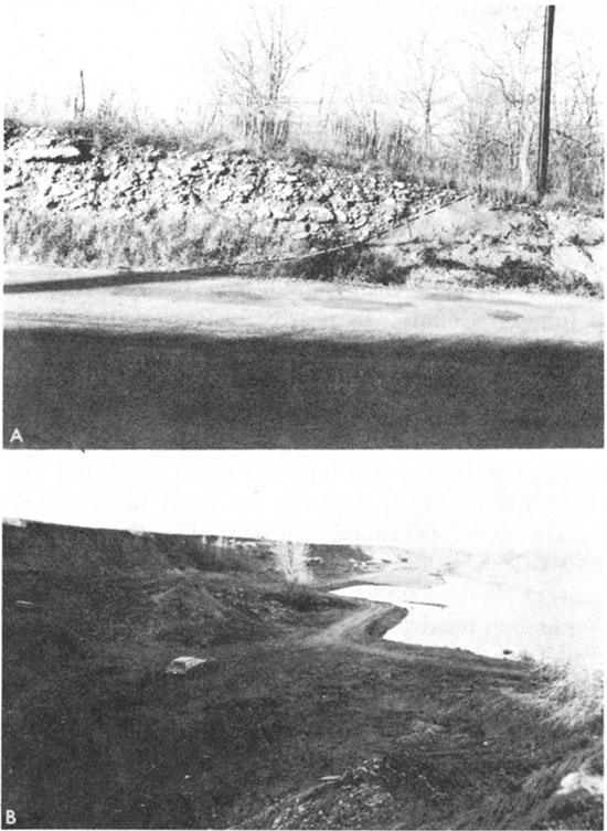
The second largest area of Kansan deposits, herein referred to as the Holliday area, is in T. 12 S., R. 23 E., just west of Holliday, and is drained principally by Clear Creek. Deposits of till and outwash fill an abandoned valley cut by an ice-marginal stream that existed when the present Kansas River valley was blocked by ice in secs. 34 and 35, T. 11 S., R. 23 E. The narrow drainage divide between the Kansas River and the headwater area of Clear Creek has deposits of till and outwash as much as 30 feet thick locally along the crest of the divide at altitudes of about 950 to 1,000 feet (secs. 17, 19 and 30, T. 12 S., R. 23 E.). At several points within the upper part of the area drained by Clear Creek are deposits of red sandy and gravelly silt and pebble, cobble, and boulder gravel. One well-exposed gravel deposit is west of Monticello (fig. 13A). Limestone cobble and boulder gravel, 8 feet or more thick and overlain by red sandy silts estimated to have a thickness of 10 to 15 feet, fills a narrow channel cut into the hillside. The cobbles and boulders are 95 percent or more local rock types, mainly limestone, and are only 5 percent or less pink quartzite, granite, and dark igneous and metamorphic rocks. This gravel probably was deposited by a short, ice-margin stream having a high gradient or was deposited as an ice-contact feature.
Figure 13--A, Kansan deposit of limestone cobble and boulder gravel west of Monticello in the SE SW sec. 16, T.12 S., R.23 E. B, Ahlskog gravel pit in the filled and abandoned glacial stream valley near Holliday in the NE NW sec. 11, T. 12 S., R. 23 E.
The sparse boulders and thin patches of red sandy silts containing glacial erratics, which are found at altitudes as high as 1,000 feet in the south part of the Clear Creek drainage area, may have been deposited partly in temporary ice-margin lakes.
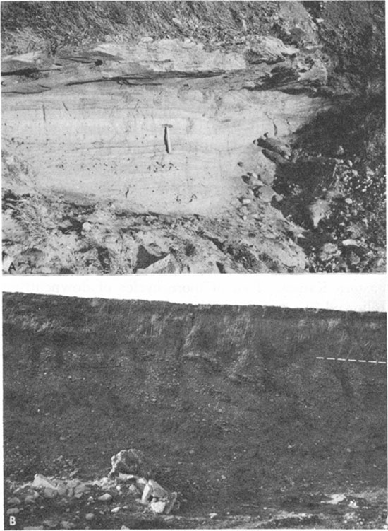
Perhaps the most spectacular deposits made by an ice-margin stream are those exposed in the old Ahlskog gravel pit on the List and Clark Construction Co. property (figs. 13B; 14A, B). About 30 feet of Kansan deposits is exposed in the walls of this gravel pit. Steeply dipping foreset beds of poorly sorted pebble, cobble, and boulder gravel, chiefly limestone, in many parts of the pit overlie almost-flat-lying beds of sand and gravel. Parts of the sand and gravel beds are tightly cemented with calcium carbonate, whereas other parts are uncemented and loose. A variable thickness of red sandy silt overlies all the deposits. The maximum thickness of Kansan deposits in this filled valley is not known, but Newell (1935, p. 83) reported that the thickness exceeds 80 feet and Dufford (1958, p. 46) reported more than 100 feet of glacial outwash in the Holliday area. Part of this filled valley was eroded to an altitude slightly below that of the present Kansas River flood plain for a short distance downstream from Wilder. Whether a narrow and much deeper till or outwash-filled gorge, such as has been found a few miles farther east at Kansas City, underlies a part of this area is not known.
Figure 14--Ahlskog gravel pit in the NE NW sec. 11, T. 12 S., R. 23 E. A, Cemented and uncemented sand and fine gravel. B, Red sandy silts overlying steeply dipping beds of poorly sorted gravel.
Late Kansan deposits equivalent to the Sappa Formation of central and western Kansas are predominantly silt and sandy silt. The deposits are at the land surface, or below a thin cover of Loveland or Peoria Formation, and they commonly overlie sand and gravel deposits equivalent to the Grand Island Formation of central and western Kansas. The silts and sandy silts are commonly leached and are oxidized to yellowish red or reddish brown where they are in a well-drained topographic position. The Pearlette ash bed, of late Kansan age, is present in the lower part of these silts along the north bluff of the Kansas River valley about 1 mile north of DeSoto, Kans. (NW SW NE sec. 21, T. 12 S., R. 22 E.), just outside this study area.
The Pearlette ash deposit is 0.6 foot thick and the upper half has been altered to clay (Ada Swineford, oral commun., 1965). The ash overlies 10 feet of finely laminated and even-textured silt and clay which, in turn, overlies Kansan sand and gravel. The ash is at an altitude of about 810 feet and is about 23 feet above the surface of the Kansas River alluvium. The Pearlette ash firmly dates the deposits as late Kansan (Swineford, 1963).
Kansan deposits, both till and outwash, occur as much as 200 feet above the Kansas River flood plain in an area 1 to 10 miles south of the valley and as low as the present flood plain at the edge of the valley. A part of the coarse gravel at the bottom of the valley fill, below the Wisconsinan and Recent alluvium, may be Kansan in age.
Illinoisan Stage
During the Illinoisan Stage, continental glaciers approached no closer to northeastern Kansas than eastern Iowa and western Illinois, and the volume of Illinoisan deposits is much less than the volume of deposits of the preceding Kansan glaciation or the succeeding Wisconsinan glaciation. Indirect effects of the Illinoisan glaciation in northeastern Kansas were the erosion of much of the previously deposited alluvium and till occurring in and along the Kansas River valley and its tributaries and the entrenchment of the Kansas River, followed by filling with unnamed sand and gravel deposits and with silt deposits of the Loveland Formation. Illinoisan alluvial deposits were almost completely removed along the Kansas River valley in Johnson County during the Wisconsinan and Recent Stages. The Illinoisan deposits that remain are beneath the dissected Buck Creek terrace (Davis and Carlson, 1952, p. 213) along the major tributaries of the Kansas River. The Buck Creek terrace is in an intermediate position between the prominent Kansan outwash deposits along the Kansas River valley and the Newman terrace and alluvium. It has a prominent Sangamon Soil developed in the upper part of the Loveland. Only three small areas of Illinoisan deposits (Buck Creek terrace) are shown on plate 1. Near the mouth of Cedar Creek, the surface of the Buck Creek terrace is about 20 to 25 feet above the younger and more extensive Newman terrace. The Illinoisan de-posits are not differentiated from the more extensive Wisconsinan and Recent alluvial deposits in the tributary valleys but are included with alluvial deposits mapped as Qtu on plate 1.
Unnamed Sand and Gravel Deposits
Water-laid sand and gravel deposits of Illinoisan age constitute the lower part of the alluvial fill under-lying the Buck Creek terrace. No remnants of the Buck Creek terrace remain in the Kansas River valley in Johnson County, but the thickness, character, and position of Illinoisan deposits relative to stratigraphic units older and younger are known from studies in adjacent areas where deposits underlying the Buck Creek terrace have been called Crete Formation (Davis and Carlson, 1952, p. 213 and 229; and Dufford, 1958, p. 25-26). The term "Crete Formation" is now restricted to usage in central and western Kansas (Bayne and O'Connor, 1968). Dufford (1958, p. 47) reported 24 feet of terrace deposits, including 4 feet of silty sand at the base of the terrace, which he judged to represent the Crete Formation, along a small tributary of the Kansas River just outside the area of this report (NW 1/4 sec. 9, T. 12 S., R. 21 E.). Similar deposits probably are present along the principal tributaries of the Kansas River in Johnson County.
Loveland Formation
The Loveland Formation occurs in two phases: 1) as alluvial deposits of sandy to clayey silt in the upper part of the alluvial fill below the Buck Creek terrace along the tributary stream valleys of the Kansas River, and 2) locally as thin eolian silt deposits on the uplands along the Kansas River valley.
The alluvial phase of the Loveland Formation, which comprises the upper part of the deposits underlying the Buck Creek terrace, consists of silt and clay, locally sandy; its contact with the underlying unnamed sand and gravel deposits is gradational. The alluvial Loveland has a thickness of 10 to 20 feet, except near the Kansas River where it may be as much as 40 feet thick. In the headwater areas of the tributaries, alluvial Loveland converges with the Wisconsinan and Recent alluvium and may be less than 10 feet thick. Because the upper part of the alluvial Loveland is well drained where it is present along the tributary valleys, it has a well-developed reddish-brown Sangamon Soil at its surface.
The eolian or loess phase of the Loveland Formation forms a thin and discontinuous silt cap on some of the hills along the Kansas River and on the uplands in northeastern Johnson County. The thickness of Loveland loess is less than 8 feet.
The alluvial and eolian Loveland deposits are leached of all carbonates and contain no fossil mollusks in exposures that were studied. The eolian Loveland is entirely within the Sangamon Soil profile.
Wisconsinan and Recent Stages
Deposits of gravel, sand, silt, and clay that occur as alluvial fill in the stream valleys of Johnson County are predominantly Wisconsinan and Recent in age and comprise much of the deposits mapped as alluvium and Newman terrace deposits on the geologic map (pl. 1). Undifferentiated terrace and colluvial deposits in the tributary stream valleys also are largely of Wisconsinan and Recent age. Thin loess deposits of the Peoria Formation are of early Wisconsinan age.
Although the Wisconsinan glaciers did not extend into Kansas, they repeatedly invaded the Missouri Valley region north of Kansas and had a profound effect on the fluvial and eolian sedimentation in northeastern Kansas. Two or more cycles of downcutting followed by aggradation have occurred in the Kansas River valley as a result of the early and late Wisconsinan glaciations into the Missouri River valley of Iowa, Nebraska, and North and South Dakota.
Peoria Formation
The more extensive of the Wisconsinan loess deposits in Johnson County are of early Wisconsinan age (table 3). These loess deposits are named the Peoria Formation and are found as a widespread but discontinuous blanket of silt on the uplands. The Peoria Formation is thickest along the bluffs of the Kansas River and in the northeastern part of the county. Peoria loess is much thicker along the bluffs south and east of the Missouri River valley than along bluffs of the Kansas River valley, suggesting that the primary source of the silts was the Missouri River valley and that the Kansas River valley was only a secondary source from which the wind-blown silts were derived.
Peoria silts are yellowish brown to yellowish gray, completely leached, and devoid of any observed fauna in Johnson County. The maximum thickness of Peoria is about 15 feet in the northeastern part of the county. Peoria silts thin to the south and west, but even in the southwestern part of the county 0.5 to 3 feet of Peoria loess is present locally. Over much of the upland area 2 to 6 feet of Peoria is common. The Peoria loess is not mapped on plate 1 because the deposits are thin and it is difficult to accurately identify and delimit them.
The Bignell Formation, a loess deposit younger than the Peoria, is recognized along the Missouri River valley of northeastern Kansas. If the Bignell is present in Johnson County, it is so thin that it is included entirely within the A-horizon of the modern soil profile.
Deposits of Newman Terrace
The Newman terrace is a prominent and widespread low surface in the Kansas River valley of east spread low surface in the Kansas River valley of eastern Kansas. It is not, however, present in the Kansas River valley in Johnson County. Deposits beneath the Newman terrace constitute a major part of the alluvial valley fill in tributaries such as Captain Creek, Kill Creek, Cedar Creek, and Mill Creek and probably also the eastward-draining tributaries such as the Blue River.
The Newman terrace is flat, poorly drained, and bordered by low natural levees. It is still being raised by slight accretion each time it is covered by floodwaters.
In Cedar Creek valley the Newman terrace is about 30 feet below the Buck Creek terrace and is about 30 feet above the average low-water stream level of Cedar Creek. One test hole (12-22E-26dab) in Newman terrace deposits at the mouth of Cedar Creek valley penetrated more than 70 feet of alluvial fill and probably represents a near-maximum thickness of the deposits. The upper part of the alluvial deposits in this test hole is medium to dark gray and gray brown and is chiefly silt and clay. Descriptions of Newman terrace deposits elsewhere in the Kansas River valley and major tributaries (Davis and Carlson, 1952; Dufford, 1958; and O'Connor, 1960) indicate that the upper 8 to 50 feet of the deposits is typically dark and clayey. The basal part of the alluvial fill beneath the Newman terrace at the mouth of Cedar Creek is sandy and gravelly and includes much silt.
The dark clay that everywhere is found in the upper part of the deposits underlying the Newman terrace is judged to be of late Wisconsinan and Recent age. Both early and late Wisconsinan sediments may be represented, but the deposits have not been dated by fossils or by other means. The sandy and gravelly basal part, likewise, has not been dated but may be of Wisconsinan or Kansan age. The deposits mapped as Qtu on plate 1 are chiefly of Wisconsinan and Recent age, and are equivalent to those underlying the Newman terrace and to alluvium in the Kansas River valley; they also include some older Pleistocene deposits.
The composition of the deposits in the tributary valleys reflects the lithology of the rocks that crop out within the drainage basins. Tributaries draining appreciable areas of sandstone or sandy Kansan glacial and fluvial deposits have sandier fillings than do other valleys. The nature of these fillings is shown by logs of test holes given at the end of this report.
Alluvium
Deposits mapped as alluvium (pl. 1) along the Kansas River and its tributaries are Wisconsinan and Recent in age and underlie an irregular surface about 3 to 20 feet below the Newman surface. In most of the tributary valleys the Wisconsinan and Recent terraces and the deposits that underlie them are not differentiated and are not mapped separately.
In the Kansas River valley the surface of the alluvium is marked by meander scroll patterns and irregularities commonly having a relief of 5 to 10 feet. These irregularities resulted from the gradual down-cutting during progressive, non-uniform downstream migration of meanders. Point-bar accretion slopes are so gentle that they may be interpreted as representing one or more minor terraces. Dufford (1958) considered four distinct surfaces below the Newman terrace, but he did not map any of them as terraces. The four surfaces were distinguished on the basis of the degree of soil development, radius of curvature of the meander scrolls, and relative altitude of the different surfaces. Locally the distinctions between surfaces are so subtle that the surfaces cannot be identified with certainty. In this report all the valley surface below the Newman terrace is mapped as alluvium on plate 1.
The surficial deposits of alluvium are generally light colored and sandy, and contrast markedly with the dark silt and clay "backswamp" deposits at the Newman surface. Test-hole data indicate that the upper 35 to 45 feet of sediments in the alluvium is similar to sediments transported by the Kansas River today. Wyman (1935, p. 229-230) indicates that the largest fragments of rock recovered in 34 samples of bed load from the Kansas River collected by the U.S. Army Corps of Engineers did not exceed 64 mm in diameter (pebble gravel).
Very fine, fine, and medium sand comprise much of the upper part of the alluvium. Thin lenses of gray silt and clay occur locally in the upper part of the alluvium and may represent fine-grained sediment deposited on the bottom of meander scrolls. Sediments are coarser in the lower part of the alluvium and are predominantly medium sand to granule gravel (0.2 to 4 mm). The basal part of the alluvium almost everywhere contains gravel in the size range of cobbles and boulders, which is much larger than the rock fragments being transported by the Kansas River today. The basal part of alluvial fill, that part containing cobbles and boulders, may be of Wisconsinan or Kansan age.
The segment of the Kansas River valley in Johnson County that is entrenched into rocks of the Kansas City and Lansing Groups is the narrowest section of the valley between Manhattan and Kansas City. The valley ranges in width from about 1.1 to 1.8 miles, and the alluvial fill ranges in thickness from about 40 to 70 feet.
Interglacial Stages
The interglacial stages are represented in northeastern Kansas primarily by buried soils, or paleosols, and represent the time between glacial stages when the continental interior of North America was free of ice caps and the sea level in the coastal areas was essentially stable.
Although the Afton, Yarmouth, and Sangamon Soils are all believed to be represented in Johnson County, in addition to the modern soil, the paleosols were not studied in detail, and only brief comments about their nature and extent are given. The Brady Soil has not been recognized in Johnson County.
The Aftonian Stage, oldest of the Pleistocene interglacial stages, may be represented by a soil developed on Pennsylvanian rocks and locally preserved beneath deposits of Kansan age.
The Yarmouthian Stage is represented by the Yarmouth Soil and is developed extensively on the Kansan deposits in northern Johnson County. Where the Yarmouth Soil is developed on Kansan silts in a well-drained position, it has a thick B-horizon that is red, leached, and enriched with clay. James Thorp (written commun., 1965) has identified the buried Yarmouth Soil in the Ahlskog gravel pit (E 1/2 NW 1/4 sec. 11, T. 12 S., R. 23 E.). Thorp measured and described the soil and paleosol above the gravel in the northeastern part of the pit. At this site the modern soil, 4.7 feet thick, is developed on Peoria loess and overlies a dark-reddish-gray and reddish-brown buried A-horizon about 1 foot thick. Thorp estimated that this buried A-horizon contained 30 percent clay, 10 percent sand, and 60 percent silt. It contains many small pockets and streaks of black carbon. The B-horizon, at depths from 5.7 to 14.2 feet, is reddish brown, red, and yellowish red and has a clay content of 35 to 45 percent. Many tubular voids (0.1 inch in diameter) and spheroidal voids (0.5 to 0.8 inch in diameter) in the buried B-horizon are coated or half-filled with illuvial clay derived largely from the buried A-horizon but partly from the modern soil. Thorp considered that the buried A-horizon and part of the B-horizon, from 4.7 to 6.0 feet in depth, might possibly be Loveland loess, and that the Sangamon Soil may have developed on a truncated Yarmouth Soil. In areas where the Yarmouth Soil is developed on Kansan silts in a poorly drained profile, the B-horizon is a heavy gray clay mottled with brown, pink, and red.
The Sangamonian Stage is represented by the widespread Sangamon Soil. Where the soil is developed in a well-drained profile on Illinoisan terrace deposits, it has a thick reddish-brown B-horizon and is leached to a depth of more than 20 feet.
Much of the relatively flat upland, which is underlain at a depth of a few feet by the Stanton Limestone and the lower part of the Stranger Formation, has a thin cover of Peoria loess at the land surface. The modern soil, developed on this Peoria loess in much of the upland, overlies a very sticky tenacious mottled clay, about 5 feet thick, that is believed to be part of the Yarmouth Soil or Sangamon Soil, or both, that developed under conditions of poor drainage.
Prev Page--Dakota Formation || Next Page--Structural Geology
Kansas Geological Survey, Johnson County Geohydrology
Web version April 2002. Original publication date Dec. 1971.
Comments to webadmin@kgs.ku.edu
The URL for this page is http://www.kgs.ku.edu/General/Geology/Johnson/05_outcr5.html