![]()
Prev Page--Kansas City Group || Next Page--Douglas Group
Stratigraphy of Outcropping Rocks, continued
Lansing Group
Plattsburg Limestone
The Plattsburg Limestone is the lowermost of the three formations in the Lansing Group. It is divided into three members: Merriam Limestone, Hickory Creek Shale, and Spring Hill Limestone. The formation ranges in thickness from about 7.5 to 23 feet in surface exposures. Drillers' logs indicate a range in thickness from about 7.5 to 29 feet in the subsurface.
Merriam Limestone Member
The Merriam Limestone Member was named by Newell (in Moore, 1932) for exposures in the town of Merriam, Kans., but no measured section of the "type" Merriam was published. The rocks exposed at the type locality (quarry at NW cor. sec. 7, T. 12 S., R. 25 E.), as later defined by Moore (1935, p. 128), are stratigraphically below the Merriam, Therefore, a detailed standard reference section of the Merriam in the type locality still was not available. Considerable confusion regarding the Merriam and adjacent beds exists
In Johnson County because, in earlier stratigraphic works a limestone in the Bonner Springs Shale was identified as Merriam, and, in another instance, a limestone conglomerate or breccia stratigraphically below the Merriam was included in the Merriam.
There seems to be no question as to what beds Newell intended to designate as the Merriam Limestone Member, yet the lack of a published type section has resulted in miscorrelations, The following graphic column and measured section of the Merriam Limestone Member and adjacent beds, therefore, are included as a standard reference section in the type locality. The graphic column is illustrated on figure 11.
Figure 11--Graphic column of the reference section of the Merriam Limestone Member of the Plattsburg Limestone and adjacent beds, SE SW SE, sec. 12, T. 12 S., R. 24 E. Numbers refer to measured sections in text.
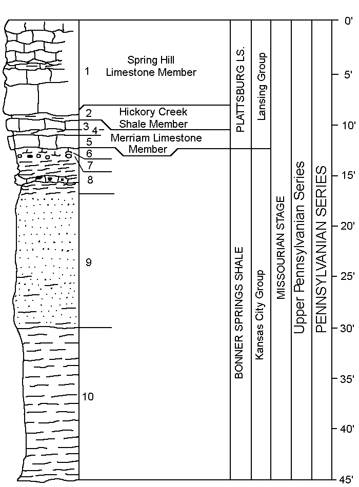
| Reference measured section of the Merriam Limestone Member of the Plattsburg Limestone and adjacent beds exposed along the northeast loop of the U.S. highway 50-Interstate Highway 35 interchange at Merriam, Kans., (SE SW SE sec. 12, T. 12 S., R. 24 E.). | |||
| Thickness (feet) |
|||
|---|---|---|---|
| Plattsburg Limestone | |||
| Spring Hill Limestone Member | |||
| (1) Limestone, light-gray, medium- to thick-bedded, fine-grained; weathers yellowish brown to yellowish orange; fossiliferous uppermost part weathered and partly eroded | >9. | ||
| Hickory Creek Shale Member | |||
| (2) Shale, medium-gray; weathers olive gray | avg. 0.3 | ||
| Merriam Limestone Member | |||
| (3) Limestone, light-gray; weathers yellowish gray; upper part contains numerous ferruginous clay-filled borings and is sparsely fossiliferous; lower part is slightly argillaceous and contains abundant fusulinids and crinoid fragments, and a few brachiopods | avg. 1.5 | ||
| (4) Shale, greenish-gray; abundant bryozoans | 0.2 | ||
| (5) Limestone, very light gray; the alga Osagia is abundant in the upper and lower parts and Composite is abundant in the middle part; productids locally numerous in the upper middle part; sparse Myalina at base | 1.1 | ||
| Bonner Springs Shale | |||
| (6) Shale, gray to olive-gray, silty, micaceous, calcareous: abundant fossils in upper part, especially Composita, and Aviculopecten | avg. 0.8 | ||
| (7) Conglomerate and impure limestone or "marlite," gray and yellowish-brown to yellowish-orange; thickness is variable | avg. 0.1 | ||
| (8) Shale, olive-gray to greenish-gray, and green claystone; contains near the middle a yellowish-brown to yellowish-orange impure limestone or "marlite," 0.5 to 1.0 foot thick, which grades laterally into yellow and gray conglomerate | 4.7 | ||
| (9) Sandstone, grayish-blue to gray, very fine to fine-grained, quartzose, micaceous; upper part more massive bedded; lower part is shaly | 12.3 | ||
| (10) Shale, bluish-gray, silty, micaceous, sandy at top; weathers yellowish gray | 15.1 | ||
The Merriam Limestone Member in the foregoing reference section is 2.8 feet thick and consists of two limestones separated by a thin shale parting. In Johnson County the lower blocky limestone bed is light gray to yellowish gray and is characterized by a molluscan zone with Myalina, Aviculopecten, and gastropods common at the base, a zone of abundant Composita in the middle or lower part, and abundant Osagia. The middle and upper parts of the bed locally are oolitic limestone. Crinoid and bryozoan fragments are fairly common but are not diagnostic of the bed. The bed is commonly about 1 foot thick, but locally may be as much as 4.2 feet thick; it consists largely of algal and oolitic limestone, as in road cuts in the SW SW SE sec. 30, T. 13 S., R. 23 E.
Overlying the lower limestone bed of the Merriam is a thin blue or bluish-gray calcareous shale that weathers green or gray and contains sparse bryozoans and Aviculopecten. At the reference section the shale ranges in thickness from a parting to about 0.2 foot.
The upper limestone bed of the Merriam is generally a single light-gray massive vertically jointed limestone, 0.5 to 1 foot thick, that weathers light gray, yellowish gray, or dusky yellow. It is fine grained and dense but some crystalline limestone has replaced shell fragments. It has a characteristic fauna of fusulinids, brachiopods, and crinoid fragments. The upper part is characterized by a pitted upper surface and small borings, considered by some to be worm borings, about one-fourth of an inch in diameter and as much as 3 to 5 inches in length, filled with a soft yellow ferruginous clay. The borings commonly are steeply inclined. The Merriam described in the reference section is judged to be the unit defined by Newell. Locally, the Merriam contains small nodules of gray chert. In some exposures one or the other of the distinctive lithologies may be absent or poorly represented, but the member is one of the more easily identified units in the county. It ranges in thickness from about 0.8 foot to about 6 feet.
In the reference section the 6 feet of shale between the Merriam and the quartzose sandstone in the middle part of the Bonner Springs contains calcareous and silty molluscan limestones, thin zones of conglomerate or pebbles containing mollusks, green and gray shales, and a "marlite bed. This interval in the upper Bonner Springs is widely distributed in Johnson County and should not be considered as part of the Merriam.
Hickory Creek Shale Member
The Hickory Creek Shale Member consists chiefly of calcareous shale that ranges in color from light olive gray to greenish black, being darkest in the northeastern part of the county. The shale weathers yellowish gray to grayish orange. The Hickory Creek locally includes nodules of limestone or an impure argillaceous irregular bed of fine-grained limestone, commonly 0.2 to 0.4 foot thick that weathers yellowish orange. Both the shale and the limestone are fossiliferous; brachiopods, crinoids, and bryozoans are common, fenestrate bryozoans being very abundant in some outcrops. Fusulinids occur locally in the member. The member ranges in thickness from 0 to about 3 feet but commonly is about 1 foot thick. A restudy of the Hickory Creek Shale Member in the DeSoto area, where it was earlier reported by Newell (1939, p. 69) to be 20 feet thick, indicates that the Merriam Limestone Member and the upper beds of the Bonner Springs Shale were included in the Hickory Creek.
Spring Hill Limestone Member
The upper and predominant part of the Plattsburg Limestone is the Spring Hill Limestone Member. It ranges in thickness from about 8 to 23 feet in outcrops and also in the subsurface.
The limestone can be differentiated into several faunal and lithologic zones. The lower part, commonly a third to half of the member, appears massive in flesh outcrops, but, upon weathering, thin shaly partings that separate the even to slightly wavy beds of limestone, 2 to 12 inches thick, become evident. This part of the member is light to medium gray or light olive gray in fresh exposures but weathers grayish orange to yellowish orange. The limestone is fine grained with coarser grained fossil debris unevenly distributed through the rock. The lower beds contain abundant bryozoans and brachiopods, especially Enteletes and Marginifera, crinoids, and fusulinids. Nodules of light-gray chert commonly are found in the lower beds, but locally in the Wolf Creek and Little Bull Creek drainage areas, the Spring Hill contains abundant large chert nodules.
The middle part of the member consists of yellowish-gray to light-olive-gray limestone beds, which contain much finely broken fossil detritus composed of bryozoan, crinoid, and echinoid fragments, foraminifera, brachiopods, small gastropods, and Osagia. At the top of the middle beds in many outcrops fewer broken fossils are noted and, locally, unbroken Composita shells are abundant. Elsewhere, especially in southern Johnson County, the middle beds consist almost entirely of oolitic and pelletal limestone with small amounts of Osagia, bryozoan fragments, and foraminifera. The pellets are filled with a mosaic of crystalline calcite or dark-yellowish-orange limonite in weathered exposures. The pelletal limestone ranges from medium dark gray to nearly white and weathers very light gray to yellowish gray. Original void space between ooliths or pellets is cemented with very finely crystalline limestone or with sparry calcite.
The upper Spring Hill beds are about 1 to 5 feet thick and consist of gray argillaceous massive finely crystalline to granular limestone that weathers yellowish orange or yellowish brown. An algal and molluscan fauna is common, but echinoderms, bryozoans, and brachiopods are predominant in some exposures. Several thin gray fossiliferous shale partings, which are as much as 0.5 foot thick, separate some of the limestone beds but are not persistent from one exposure to the next.
Vilas Shale
The Vilas Shale is the middle formation of the Lansing Croup. Measured sections of this unit average about 15 feet thick, but the unit ranges in thickness from about 8 feet (SW sec. 9, T. 15 S., R. 22 E.) to 25 feet (NE NE SE sec. 12, T. 12 S., R. 23 E.), being thickest in the northern part of the county and thinnest in the southwestern part.
The lower third to half of the formation is medium-to dark-gray and dark-greenish-gray mudstone and silty or sandy and micaceous shale with carbonized plant fragments. As much as 1.1 feet of sandstone and siltstone is found locally in the lower and middle parts (NE NE SE) sec. 12, T. 12 S., R. 23 E.). Exposures of the lower Vilas beds west of Bull Creek along Interstate Highway 35 (SW sec. 9, T. 15 S., R. 22 E.) are about 2.7 feet thick and contain a thin intraformational conglomerate of limestone and shale fragments about 2 feet above the base of the formation.
Middle Vilas beds range from about 0.5 to 4 feet in thickness and, in most exposures, are either calcareous and fossiliferous fine-grained sandstone or fossiliferous sandy limestone. Very thin beds of sandy limestone locally contain abundant bryozoans, especially Rhombopora and Fenestella, as well as Composita, Neospirifer and other brachiopods, crinoid fragments, Myalina, and Aviculopecten. In a few exposures, caliche-like nodules of limestone are scattered through the sandy beds, and bedded sandy limestone is absent.
The upper Vilas beds are chiefly gray and olive-gray shale, which locally is sandy or silty. Near DeSoto, in exposures along the east side of a lake (SW NW sec. 28, T. 12 S., R. 22 E.), a thin very fine grained sandstone occurs about 5 feet above the middle fossiliferous sandy limestone. In most exposures, the uppermost part of the Vilas is light-colored calcareous shale that weathers yellowish gray.
Stanton Limestone
The Stanton Limestone comprises three limestone and two shale members. It lies at or near the surface in much of the upland area in central Johnson County. The formation ranges in thickness from about 36 to 47 feet.
Captain Creek Limestone Member
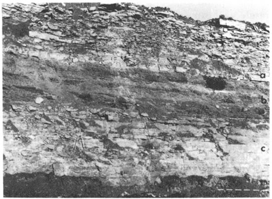
The lowermost unit of the Stanton Limestone is the Captain Creek Limestone Member. The member has a minimum thickness of about 4.5 feet in northeastern and northwestern Johnson County and a maximum observed thickness of 10 feet in southwestern Johnson County (fig. 12). Most of the member consists of even to slightly uneven beds of limestone, 4 to 12 inches thick.
Figure 12--Stanton Limestone along Interstate Highway 35 near the center of the north side of the NW sec. 16, T. 15 S., R. 22 E. a, Stoner Limestone Member. b, Eudora Shale Member. c, Captain Creek Limestone Member. Folding carpenters rule is 6 feet long.
The lower part of the Captain Creek consists of one or two beds of medium-gray to olive-gray fine- to medium-grained limestone containing abundant Osagia and lesser amounts of Cryptozoan algal structures, gastropods, Myalina, crinoid fragments, fusulinids, and Composita. Locally a thin gray shale, ranging in thickness from 0 to about 0.2 foot and containing fusulinids, crinoids, and brachiopods, overlies and separates the lower beds from the rest of the member.
The upper part of the Captain Creek is about 3 to feet thick amid constitutes most of the member; it is medium-gray to light-bluish-gray medium-bedded fine-grained to aphanitic limestone. Brachiopods, crinoid remains, fusulinids, bryozoans, and algae are common. Composita, Enteletes, and algae are the most conspicuous and abundant fossils. Algae are particularly abundant near the top of the member. The algae occur as thin irregular veins or crusts of clear crystalline calcite, ranging in thickness from about 0.2 to 3 mm, in a very fine grained lime-mud matrix. In many exposures the top part (less than 2 feet) of this bed has a distinctive mottled and brecciated appearance that has been noted in previous reports (Newell, 1935, p. 77; Moore, 1935, p. 133). The limestone is very light gray to grayish black, mottled with pale to moderate red. Like other mottled limestones of the Kansas City and Lansing Groups, it has been considered to be of algal origin. The mottled bed locally is separated from the other limestone beds by a shale parting.
Gray chert nodules are found locally near the middle of the member, but are nowhere very abundant. Small pink or gray chert nodules locally are found in time mottled bed at the top also.
Eudora Shale Member
The Eudora Shale Member (fig. 12) includes a zone of grayish-black fissile to platy shale in the lower part, which is distinctive in the Lansing Group. The Eudora is 6 to 8 feet thick in most exposures, but, according to Newell (1935, p. 77), may be as much as 11 feet thick locally.
The lower 0.1 to 1.5 feet of the member is gray to greenish-gray calcareous to limy shale, which is overlain by 2 to 4.5 feet of more resistant grayish-black hard fissile to platy shale, which, in turn, is overlain by 3 to 6 feet of light- to dark-gray or greenish-gray partly calcareous shale. Small elliptical gray or brownish-gray phosphatic nodules are scattered through the grayish-black fissile shale. Conodonts, a few Orbiculoidea, Lingula, and Conularia, and carbonized plant fragments also are found in the black shale. A few small clams and brachiopods occur in the overlying gray shale.
Stoner Limestone Member
The Stoner Limestone Member, which averages 13 to 18 feet thick, is the thickest unit of the Stanton Limestone. The Stoner forms the most prominent bench along the Stanton outcrop. The member consists of medium-light-gray to very light gray and greenish-gray thin- to medium-bedded irregular wavy limestone with thin shale partings (fig. 12). In some outcrops the lowermost limestone bed is more massive and even-bedded than middle beds of the member.
The wavy thin- to medium-bedded fine- to medium-grained limestone that comprises the middle part of the member is not as fossiliferous in general as similar wavy-bedded limestones in the Kansas City and Lansing Groups. Brachiopods, bryozoans, horn corals, crinoid and echinoid remains, fusulinids, and ostracodes are common, with large brachiopods such as Antiquatonia, Composita, and Echinaria being most conspicuous. Parts of the limestone beds contain coarsely crystalline calcite as void fillings and replacement of shell material.
The uppermost 0.5 to 3 feet of limestone in many exposures consists of "osagite" or calcarenite, or of brecciated or nodular-appearing limestone. Both the calcarenite and the nodular limestone are well developed in the Olathe area and are exposed in road cuts along Kansas Highway 150 (NE NE sec. 31, T. 13 S., R. 24 E.) and Kansas Highway 7 (SE NE sec. 27, T. 13 S., R. 25 E.). The nodular beds consist of medium- to dark-gray or olive-gray dense sublithographic limestone in a matrix of greenish-gray fine-grained argillaceous limestone. The fine-grained limestone matrix locally contains gastropods, clams, productid brachiopods, and finely broken fragments of bryozoan and other fossil material.
Rock Lake Shale Member
The Rock Lake Shale Member consists chiefly of shale and sandstone but also includes siltstone and conglomerate. In the northwestern part of the county grayish-black carbonaceous shale amid a thin laminated limestone are present. The member ranges in thickness from about 2 to 14 feet, but averages 8 feet.
The shale is medium light gray to dark gray or olive gray. Locally the shale beds are conglomeratic and have subrounded to subangular shale pebbles of one lithology enclosed in shale of slightly different lithology. Several exposures of the Rock Lake along Captain Creek in western Johnson County (SE cor. sec. 26, T. 13 S., R. 21 E., and near the NW SW SW sec. 1, T. 14 S., R. 21 E.) have a grayish-black carbonaceous shale, 0.5 foot thick, overlain by a medium- to dark-gray laminated limestone containing abundant ostracodes, foraminifera, carbonized plant fragments, and spores.
The sandstone is gray but weathers yellowish gray to dark yellowish orange and is very fine to fine grained, quartzose, and micaceous. It may be weakly cemented and friable or strongly cemented with calcite as seen in surface exposures. Locally, where the member attains its greatest thickness, it includes beds of sandstone and siltstone. In places, nearly the entire unit is sandstone, Marine fossils, especially large Myalina and Aviculopecten, are found in the sandstone; small Myalina and fragments of other fossils are found in some of the shale beds, but other shale beds apparently are barren of marine macrofossils. The shales, siltstones, amid sandstones all contain carbonized plant fragments.
In several exposures the upper part of the Bock Lake is gradational upward from sandstone to sandy limestone, and the boundary between the Rock Lake amid time overlying South Bend Limestone Member is not clearly defined. Locally, the sandstone beds contain a sandy limestone conglomerate.
South Bend Limestone Member
The uppermost member of the Stanton Limestone is the South Bend. The member is medium- to thick-bedded dense very fine grained limestone that ranges in thickness from about 1.5 to 5 feet. In the thicker exposures, the lower part commonly is a sandy or sandy and conglomeratic limestone. Where the member overlies sandstone in the Rock Lake, the boundary may he gradational. The fresh rook is medium to dark gray or bluish gray, but weathered exposures are yellowish gray to olive gray or yellowish brown. The limestone is fossiliferous, containing abundant fusulinids, crinoids, and brachiopods. Meekella and Composita are common brachiopods. The lower sandy part is less fossiliferous and contains a molluscan fauna. Although the South Bend is near land surface in much of the upland area of central Johnson County, it is rarely well exposed except in manmade exposures.
Prev Page--Kansas City Group || Next Page--Douglas Group
Kansas Geological Survey, Johnson County Geohydrology
Web version April 2002. Original publication date Dec. 1971.
Comments to webadmin@kgs.ku.edu
The URL for this page is http://www.kgs.ku.edu/General/Geology/Johnson/05_outcr2.html