![]()
Prev Page--Table of Contents || Next Page--Geology
Introduction
This study is part of a continuing cooperative program of groundwater-resources investigations that have been conducted in Kansas since 1937. The objectives of the study were to determine the occurrence, availability, and chemical quality of groundwater, and the character and extent of the water-bearing geologic units. The report was prepared by the State Geological Survey of Kansas and the U.S. Geological Survey, in cooperation with the Division of Environmental Health of the Kansas State Department of Health and the Division of Water Resources of the Kansas State Board of Agriculture.
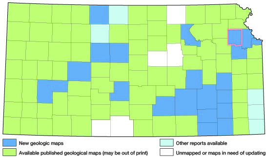
Jefferson County is an area of about 552 square miles in northeastern Kansas. It is bounded on the north by Atchison County, on the east by Leavenworth County, on the south by Douglas County, and on the west by Jackson and Shawnee Counties. Figure 1 shows the area of this study and other areas in the State for which groundwater reports have been published or are in preparation.
Figure 1--Index map of Kansas showing area described in this report and areas covered by other geologic maps, as of Jan. 2002. For additional information, see the KGS Geologic Maps of Kansas Page.
The report is based on geologic mapping, geologic interpretation of aerial photographs, test-hole logs and water-well drillers' logs, inventory of selected wells, and analyses of water samples from selected wells. The basic data are on file in the offices of the U.S. Geological Survey and the State Geological Survey of Kansas, Lawrence, Kans.
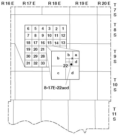
Well and test-hole numbers used in this report give the location of wells according to General Land Office surveys. The well number is composed of township, range, and section numbers, followed by letters that indicate the subdivision of the section in which the well is located. The first letter denotes the quarter section; the second letter denotes the quarter-quarter section, or 40-acre tract; the third letter denotes the quarter-quarter-quarter section, or 10-acre tract. The 160-acre, 40-acre, and 10-acre tracts are designated a, b, c, and d in a counter-clockwise direction, beginning in the northeast quarter (fig. 2). When two or more wells are located within a 10-acre tract, the wells are numbered serially according to the order in which they were inventoried. For example, well 8-17E-22acd is in the SE 1/4 SW 1/4 NE 1/4 sec. 22, T. 8 S., R. 17 E., and is the first well inventoried in that tract.
Figure 2--Well numbering system used in this report.
Reports describing the groundwater resources in and near Jefferson County are included in the Selected References.
Prev Page--Table of Contents || Next Page--Geology
Kansas Geological Survey, Jefferson County Geohydrology
Web version July 2002. Original publication date Dec. 1972.
Comments to webadmin@kgs.ku.edu
The URL for this page is http://www.kgs.ku.edu/General/Geology/Jefferson/02_intro.html