![]()
Prev Page--Introduction || Next Page--Geology
Geography
Kansas lies in the Interior Plains major physiographic division. This major division is represented in Kansas by the Great Plains and Central Lowland provinces. The provinces are divided into sections, which in turn are divided into minor physiographic divisions according to the classification of Schoewe (1949) (Fig. 3).
Figure 3--Map showing physiographic provinces in Kansas.
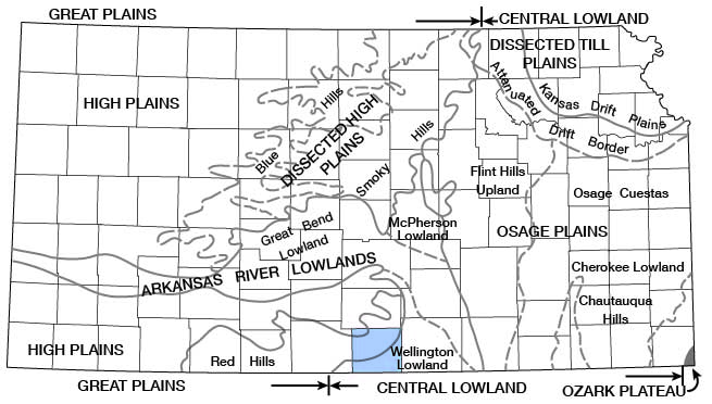
Harper County lies partly in the Wellington Lowland minor division of the Arkansas River Lowland section of the Central Lowland province and partly in the Red Hills minor division of the Dissected High Plains section of the Great Plains province. A small area in northwestern Harper County lies in the High Plains section of the Great Plains province (Schoewe, 1949).
Topography and Drainage
The Wellington Lowlands are characterized by gently rolling hills covered with a reddish soil derived from the Permian bedrock underlying the surface.
The border between the Wellington Lowland division and the Red Hills division is sharply marked by a prominent escarpment at the eastern edge of the Dissected High Plains. The thin soils in this area are red, and the land surface has considerable local relief caused by the differential erosion of resistant sandstone and siltstone beds of the Permian bedrock.
An area of a few square miles in northwestern Harper County lies in the High Plains physiographic section. Here the topography is a very gently rolling, almost featureless upland plain.
The northeastern part of the county is drained by Chikaskia River and its principal tributaries, Spring and East Sand Creeks. The central and southeastern parts of the county are drained by Bluff Creek, and the southwestern part by Big and Little Sandy Creeks.
The surface of Harper County slopes from the northwest corner toward the southeast comer. The highest altitude, 1,700 feet, is just south of the northwest corner, and the lowest altitude, 1,180 feet, is just north of the southeast corner of the county in Bluff Creek valley.
Climate
The climate of Harper County is subhumid and is characterized by moderate precipitation, a wide range of temperature, and a moderately high average wind velocity. In summer the days and many of the nights are generally hot; winters are moderately cold but generally are free from excessive snowfall.
The climatic data in this report were compiled from the records of the U. S. Weather Bureau. The normal monthly mean temperatures at Anthony range from 30.3° F for January to 80.6° F for July. The annual mean temperature is 56° F. The average annual number of days when the maximum temperature exceeds 100° F is 20 days and the average annual number of days when the minimum temperature is 32° F or below is 110 days. The average date of the first killing frost in the fall is October 25 and the average date of the last killing frost in the spring is April 13. The earliest frost of record was September 26, 1912, and the latest killing frost of record was May 15, 1907. The average growing season is 195 days. The longest growing season of record was 225 days and the shortest was 154 days.
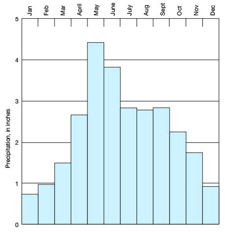
The normal annual precipitation at Anthony is 27.41 inches. The lowest annual precipitation of record was 12.54 inches in 1910 and the highest annual precipitation was 50.03 inches in 1951. The annual precipitation and cumulative departure from normal for the period of record (1896-1958) at Anthony are shown in Figure 4. About 72 percent of the annual precipitation falls during the growing season, from April through September. The lowest normal monthly precipitation is 0.70 inch, in January, and the highest normal monthly precipitation is 4.42 inches, in May. The normal monthly precipitation at Anthony is shown in Figure 5.
Figure 4--Annual precipitation and cumulative departure from normal at Anthony.
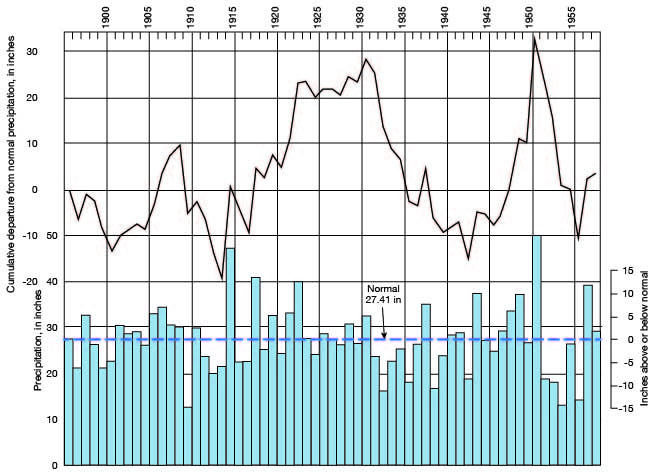
Figure 5--Normal monthly precipitation at Anthony.
Population
The population of Harper county in 1955 was 10,195. The population in 1950 was 10,263, in 1940 was 12, 068, and in 1930 was 12,823. Thus a decrease of 15 percent occurred in the period 1940 to 1950 and a decrease of 20 percent in the period 1930 to 1950. [Note: Harper County population was listed as 6,536 in 2000 U.S. census, with a density of 8.2 (32.9 for the state) (KU Institute for Policy & Social Research).] In 1950 the population was about equally divided between those living in cities and towns and those living on farms; the urban population had decreased 6.8 percent and the rural population, 14.7 percent during the preceding decade.
The principal cities and towns and their 1955 populations were: Anthony, 2,799 [2,440 in 2000]; Attica, 730 [636 in 2000]; Bluff City, 161 [80 in 2000]; Danville, 124 [59 in 2000]; Freeport, 27 [6 in 2000]; Harper, 1,829 [1,567 in 2000], and Waldron, 67 [17 in 2000].
Transportation
Harper County is served by a branch line of the Missouri Pacific Railroad Co., which enters on the east from Argonia in Sumner County and passes through Freeport, Anthony, and Corwin. The main line of the Atchison, Topeka, and Santa Fe Railway Co. serves Harper, Attica, and Danville. All other communities in the county, except Freeport and Waldron, are served by branch lines of the Atchison, Topeka, and Santa Fe.
Improved state and federal highways in Harper County total about 102 miles. U. S. Highway 160 crosses the county from east to west through Danville, Harper, and Attica. Kansas Highway 14 enters the county on the north side at Duquoin, runs south to Anthony, and thence west into Barber County. Kansas Highway 2 starts at Harper and runs northeast toward Wichita, Kansas Highway 44 runs east from Anthony into Sumner County, and Kansas Highway 179 runs south from Anthony to Manchester, Okla.
Agriculture
Harper County is primarily an agricultural county, there being 1,217 farms according to the 1955 farm census. In 1955 the total acreage of crops harvested was 236,345; the crops were valued at $3,869,000. Wheat is the principal crop, sorghums, oats, hay, and barley following in order of acreage harvested (Table 1).
Table 1--Acreages of principal crops harvested in Harper County in 1955 (From the biennial report of the Kansas State Board of Agriculture).
| Crop | Acres |
|---|---|
| Wheat | 132,000 |
| Sorghums | 58,500 |
| Oats | 15,600 |
| Alfalfa | 15,400 |
| Barley | 8,500 |
| Rye | 2,000 |
| Corn | 330 |
The livestock industry is an important part of the economy of Harper County. In 1955, the number of livestock in Harper County was as follows: beef cattle, 36,850; milk cows, 4,650; sheep, 6,700; and hogs, 2,800. Their total value was $3,486,000.
Mineral Resources
The principal mineral resources of Harper County are oil, gas, sand, and gravel. Formerly, volcanic ash and salt were mined there, but the volcanic ash has been mined out and salt mining has been abandoned.
Oil and Gas
Exploratory wells for oil and gas had been drilled in Harper County at intervals for many years prior to the discovery of the first producing oil well in 1949. This well produced from Mississippian limestone at a depth of about 4,400 feet. Gas was first discovered in commercial quantity in 1950, also in Mississippian limestone. [Current information on the oil and gas resources of Harper County is available from the KGS website.]
The 1957 production of oil in Harper County was about 782,500 barrels from 164 wells in 12 fields [270,000 barrels in 2008]. Oil was produced from Lansing-Kansas City rocks at a depth of about 3,900 feet, Mississippian limestone at about 4,400 feet, Viola Limestone at about 4,750 feet, and Viola Limestone and Simpson Group at about 4,850 feet. The cumulative production of oil at the end of 1957 was about 2,322,400 barrels [almost 36,000,000 at the end of 2008].
Gas production in the county in 1957 was about 2,030,000 thousand cubic feet [4,000,000 in 2008]. Gas was produced from 30 wells in two fields from Mississippian limestone at a depth of about 4,400 feet. The cumulative production of gas at the end of 1957 was 6,170,000 thousand cubic feet [over 290,000,000 at the end of 2008].
Sand and Gravel
Sand and gravel is produced in considerable quantity in Harper County. One pit on Bluff Creek near Attica produces washed sand and gravel from the alluvium, and the material is used for concrete aggregate and road metal. Many small pits have been opened in the county. Sand and gravel from these pits is used principally for road metal.
Prev Page--Introduction || Next Page--Geology
Kansas Geological Survey, Geology
Placed on web Feb. 27, 2009; originally published March, 1960.
Comments to webadmin@kgs.ku.edu
The URL for this page is http://www.kgs.ku.edu/General/Geology/Harper/03_geog.html