![]()
Prev Page--Contents || Next Page--Geography
Introduction
Purpose of Investigation
An investigation of the geology and ground-water resources in Harper County was begun in 1955 by the U. S. Geological Survey and the State Geological Survey of Kansas, with the cooperation of the Division of Sanitation of the Kansas State Board of Health and the Division of Water Resources of the Kansas State Board of Agriculture. The investigation was made to determine the availability and quality of ground water for domestic, stock, industrial, and irrigation supplies and to determine the geologic and hydrologic factors that control the occurrence of ground water, which is one of the principal natural resources of the county. Although the danger of seriously depleting the ground-water supply, at the present rate of withdrawal, seems very slight, there still is a definite need for adequate understanding of the quantity and quality of the available supply, where additional supplies can be obtained, and what measures may be necessary to safeguard their continuance.
Location and Extent of Area
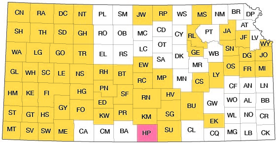
Harper County is in the south tier of counties about midway between the east and west borders of Kansas. It is bounded on the south by Grant and Alfalfa counties, Okla., on the east by Sumner County, on the north by Kingman County, and on the west by Barber County. Harper County has an area of about 810 square miles and comprises 20 townships from T. 31 through T. 34 S., and R. 5 through R. 9 W. and the equivalent of about 2 townships in the north half of T. 35 S., from R. 5 through R. 9 W. (Fig. 1).
Figure 1--Index map of Kansas showing area described in this report and areas covered by other online geologic reports, as of Feb. 2009. For additional information, please visit the KGS Geologic Maps of Kansas Page.
Previous Investigations
A detailed study of the geology and ground-water resources of Harper County has not been made previously. Several early reconnaissance reports included this part of the state and specific references were made to the county. The area was included during the preparation of the geologic map of Kansas in 1937. A report on the Pleistocene geology of Kansas by Frye and Leonard (1952) makes specific reference to this area, and a report by Swineford (1955) on the petrography of the upper Permian rocks in south-central Kansas includes this area. Studies have been made of the geology and ground-water resources of Sumner and Kingman counties adjoining Harper County, and the reports are in press.
Methods of Investigation
Field work was begun in Harper County in June 1955 and was continued through October 1955. Additional field work was done from July 1956 to October 1956. Data were collected in the field on 142 wells including the depths to water and the depths of the wells (Pl. 3 and Table 10), and information on the yield of wells and the water-bearing materials was obtained from the owners.
A total of 213 test holes, drilled in the county to determine the thickness and character of the Quaternary deposits and the character of the Permian rocks, yielded drill cuttings that were studied in the field and in the laboratory by the author. Also, 103 drillers logs were used in preparing this report. Altitudes of the measuring points of the wells and test holes were determined by a planetable and alidade survey made under the direction of E. L. Reavis.
The geology of the area was studied and mapped in the field on areal photographs and later transferred to a base map modified from a map prepared by the Soil Conservation Service of the U. S. Department of Agriculture (Pl. 1).
Samples of water from 27 wells and test holes were collected by the author and were analyzed by Howard Stoltenberg, Chemist, Water and Sewage Laboratory, Kansas State Board of Health. In addition, the analyses of 5 samples of water from municipal wells obtained from files of the Kansas State Board of Health are included in this report (Table 6).
Well-Numbering System
The well and test-hole numbers in this report give the locations of the wells and test holes according to the system of subdivision of the public lands of the U. S. Bureau of Land Management. The first numeral of the well number indicates the township; the second, the range; and the third, the section. The quarter sections (160 acres), quarter-quarter sections (40 acres), and quarter-quarter-quarter sections (10 acres) are designated a, b, c, or d in a counter-clockwise direction beginning in the northeast quadrant, as shown in Figure 2. For example, well 34-9-18bcd is in the SE SW NW sec. 18, T. 34 S., R. 9 W. If two or more wells are in a 10-acre tract, the location number is followed by serial numbers in the order in which the wells were inventoried.
Figure 2--Map of Harper County illustrating well-numbering system used in this report.
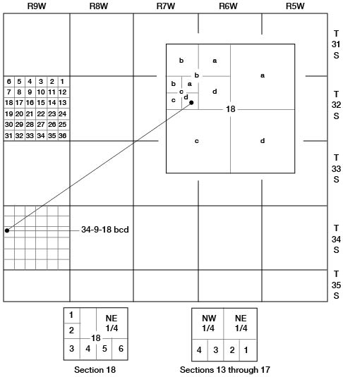
When the General Land Office survey of the area along the Oklahoma border was made, T. 35 S. was found to be only about 2 3/4 miles from north to south. The north two rows of sections in T. 35 S. were laid out as full sections and the north part of the sections bordering Oklahoma were laid out as half sections. The remaining south part of each section bordering Oklahoma was divided into four lots and, in addition, the W2 NW sec. 18 into two lots. These lots in sections 13 to 17, inclusive, are numbered serially 1 to 4 from east to west, as shown in Figure 2. Lots in section 18 are numbered serially 1 to 6 from the northwest corner counterclockwise around the west and south sides of the section (Fig. 2). Wells in these lots are not numbered according to the system described above, but are designated by township, range, section, and lot.
Acknowledgments
Appreciation is expressed to the many residents who supplied information on their wells and aided in collecting the field data. Special acknowledgment is made to the officials of the cities who furnished information regarding the municipal water supplies and to the drillers who supplied information and logs on wells and test holes in the county.
The manuscript of this report was reviewed by members of the U. S. Geological Survey and the State Geological Survey of Kansas; by R. V. Smrha, Chief Engineer, and George S. Knapp, Engineer, of the Division of Water Resources of the Kansas State Board of Agriculture; and Dwight F. Metzler, Director, and Willard O. Hilton, Geologist, of the Division of Sanitation of the Kansas State Board of Health.
Prev Page--Contents || Next Page--Geography
Kansas Geological Survey, Geology
Placed on web Feb. 27, 2009; originally published March, 1960.
Comments to webadmin@kgs.ku.edu
The URL for this page is http://www.kgs.ku.edu/General/Geology/Harper/02_intro.html