![]()
Prev Page--Stratigraphy || Next Page--Ground Water
Geologic Structure
The geologic structure of Ellsworth County is complicated by the presence of structural features of different ages, which are usually found in opposing trends. According to Lee (1956) five distinct periods of folding or structural movement have occurred in the area. The earliest affected rocks are between the Precambrian and the base of the St. Peter Sandstone. The second period affected rocks between the base of the St. Peter and the base of the Mississippian rocks. Movement in the third period began early in Mississippian time and continued through the Mississippian, reaching a maximum in the interval between the end of Mississippian deposition and beginning of Pennsylvanian deposition. The fourth period of deformation occurred during deposition of Pennsylvanian and Permian strata, and the fifth period occurred throughout Cretaceous to present time.
In the earliest period of deformation, a broad syncline (pre-St. Peter syncline, fig. 21) extended northwestward across central Kansas. This syncline included most of Ellsworth County within its boundaries. During the period between the deposition of the St. Peter Sandstone and the beginning of Mississippi deposition, the Wilson-Burns element (Koester, 1935), which is a series of dome-like structures extending from Butler County to eastern Russell County, was elevated. The Ellis arch (ancestral Central Kansas uplift) was elevated during this same period. The Central Kansas uplift and the Geneseo uplift occurred in the period between deposition of basal Mississippian rocks and the beginning of Pennsylvanian deposition. Movement probably occurred along these structures throughout the Mississippian; however, maximum activity occurred near the end of this time. A relatively short time later, in early Pennsylvanian time, the Ellsworth anticline was elevated. Minor movement occurred during the Permian and Cretaceous Periods.
Figure 21--Structural features in and adjacent to Ellsworth County.
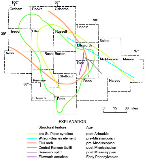
The Ellsworth-Kanopolis anticline (Lee, 1939, pl. 1) is part of the Wilson-Burns element. The Ellsworth-Kanopolis anticline was mapped by Cole (1962); the Smoky Hill River valley follows approximately the axis of this structure across most of Ellsworth County, and the course of the river may be controlled by structure along that element.
Departures of the Smoky Hill River from the axis of the crest of the Ellsworth-Kanopolis anticline, as mapped by Cole (1962) on top of the Precambrian basement, may be caused in part by superimposed reflection of the structure in younger rocks.
Mapping of the Kiowa-Dakota contact along the Smoky Hill River (pl. 1) indicates considerable apparent offset of the contact from the northeast bank of the river near Kanopolis to the southwest bank of the river south of Ellsworth, a distance of about 5 miles. The apparent offset of the contact and differences in altitude of the contact along the river indicate that the Ellsworth-Kanopolis anticline is reflected in the contact of the Kiowa and Dakota Formations. The low altitude of the contact in the area east of Kanopolis probably is due to its location on the structurally low parts of the northeast flank of the Ellsworth-Kanopolis anticline.
Three faults have been mapped at the surface in Ellsworth County (pl. 1). One mapped in sec. 35, T. 17 S., R. 6 W., is the northeastward extension of a fault mapped by Franks and Norman Plummer (Franks, 1966) in northeastern Rice County. This fault is gently arcuate, high-angled, and downthrown to the southeast. It is as much as 4 miles long. Beds on the downthrown side dip anomalously toward the fault at angles approximately 3° or less but locally measuring as much as 24° along small-scale monoclinal flexures that strike parallel to the fault. Vertical and stratigraphic displacement along the fault is difficult to judge but doubtless does not exceed 50 feet and may not exceed 15 or 20 feet. The sandy and conglomeratic nature of the basal Dakota rocks on the downthrown side of the fault and the small-scale flexures seen in basal Dakota sandstone may mean that faulting was penecontemporaneous with Dakota sedimentation. The extent to which the fault reflects solution of Permian evaporites in the subsurface and consequent collapse of overlying strata or other structural movement remains problematic.
In sec. 33, T. 17 S., R. 6 W. (pl. 1), the fault involves displacements locally approximating 30 feet. It strikes northwest and is downthrown to the southwest. Rotational movement along the fault plane is indicated inasmuch as the block of Dakota Formation preserved on the downthrown side of the fault seems to have been tilted several degrees to the southeast. Dips measured on the downthrown side of the fault are as great as 45° S. 10° E.; dips measured on the upthrown side of the fault in the Kiowa Formation are as great as 40° S. 60° E. The seemingly haphazard strikes and dips shown by beds on both the upthrown and downthrown sides of the fault may mean that the structure was caused by solution of Permian evaporites in the subsurface and consequent collapse of overlying strata.
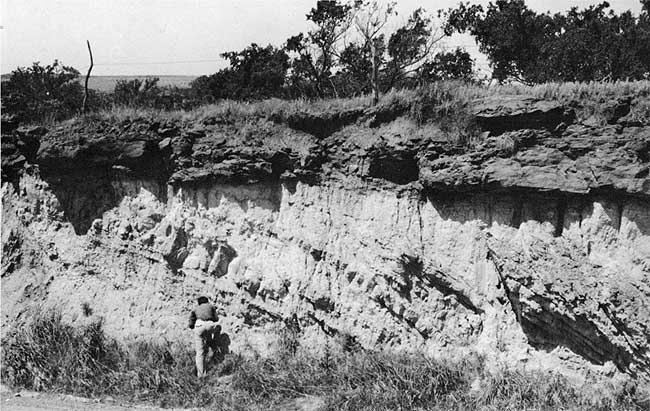
The fault exposed in a roadcut near the common corner of secs. 20, 21, 28, and 29, T. 16 S., R. 7 W., has been described previously by Ver Wiebe (1937). It is near the contact between the Kiowa and Dakota Formations, and considerably disturbed beds dipping at angles as great as 70° are truncated by sandstone within the Dakota Formation (fig. 22). The basal parts of the sandstone bed are locally involved in the deformation. Ver Wiebe (1937) assigned the disturbed rocks beneath the sandstone to the Comanche (Kiowa Formation), but widening of the roadcut in 1965 showed that the strata include gray siltstone and clay with red mottles characteristic of the Dakota Formation. Involvement of siltstone and clay in the basal parts of the Dakota Formation, together with the local involvement of the truncating sandstone, shows that the deformation was contemporaneous with Dakota sedimentation. Owing to the complexity of deformation of beds beneath the capping sandstone, the thickness of the basal Dakota clay and siltstone involved is difficult to estimate. However, approximate measurements made in the roadcut indicate that as much as 60 feet of basal Dakota sediments may be present in the disturbed sequence.
Figure 22--Deformed beds near the base of the Dakota Formation in a roadcut near the SE cor. sec. 20, T. 16 S., R. 7 W.
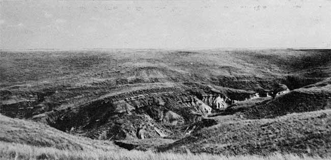
Although the Dakota-Graneros contact follows a relatively uniform surface in most of Ellsworth County, minor structural variation can be detected along it in some parts of the county. Many of the abrupt changes in altitude probably reflect local monoclinal structures. An excellent example of small-scale monoclinal folding is shown on figure 23, where the fold, which strikes about N. 70° W., is cut by a steep valley tributary to Wolf Creek. The thin siltstone bed that is just below the top of the Dakota Formation in much of Ellsworth County is warped downward about 20 feet or more to the north along the fold. Dips to the north along the flexure are as great as 15°. Similar monoclinal folding may be common in much of the area along the Dakota-Graneros contact in Tps. 14 and 15 S., R. 8 W., and one monoclinal fold showing dips of about 10° S. 80° E. is near the cen. E2 sec. 13, T. 17 S., R. 7 W., along the Kiowa-Dakota contact.
Figure 23--Monocline along the Dakota-Graneros contact in the SW sec. 19, T. 15 S., R. 9 W. Prominent siltstone near the top of the Dakota Formation is well exposed in the flexure and is overlain by a few feet of sandy and argillaceous beds that are transitional with the Graneros.
Prev Page--Stratigraphy || Next Page--Ground Water
Kansas Geological Survey, Geology
Placed on web Sept. 18, 2008; originally published March 1971.
Comments to webadmin@kgs.ku.edu
The URL for this page is http://www.kgs.ku.edu/General/Geology/Ellsworth/04_rock.html