![]()
Prev Page--Table of Contents || Next Page--Quaternary, Tertiary
Part 1--Rock Formations of Elk County
by George J. Verville; Abstracted for this report by John M. Jewett
Abstract
The surface of Elk County, in southeastern Kansas, is underlain by bedrock of Virgilian (Pennsylvanian) and Wolfcampian (Permian) age. There are local, relatively thin Pleistocene (Quaternary) deposits and accumulations of gravel that are probably of late Tertiary age. Subsurface rocks in descending order are Permian, Pennsylvanian, Mississippian, Devonian (?), Ordovician, Cambrian, and Precambrian.
Mineral resources that are being utilized include oil, gas, and limestone. Clay and a very small amount of coal are available for exploitation. Ground water that is not mineralized is not plentiful. It is present in valley alluvium and at shallow depths in some of the bedrock formations in quantities sufficient to meet the needs for domestic and stock water.
Introduction
This is the fourth in a series of reports on the stratigraphy, economic geology, and groundwater resources of eastern Kansas counties, consisting primarily of maps (Pl. 1, 2, and 3) but containing brief descriptive stratigraphy and discussions of oil and gas, ground water, and other useful geologic materials. Previously published reports in the series are on Chase County (Moore and others, 1951), Lyon County (O'Connor and others, 1952), and Osage County (O'Connor and others, 1954).
Location and Geography
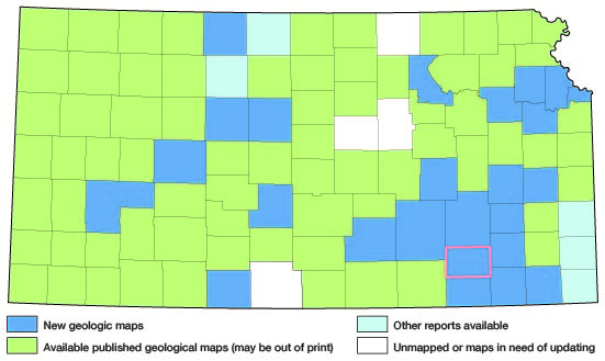
Figure 1 shows the location of Elk County in Kansas. Locations of counties that are the subjects of previously published reports in this series and areas in which studies are in progress are shown in the same figure.
Figure 1--Index map of Kansas showing area described in this report and areas covered by other geologic maps, as of Feb. 2002. For additional information, please visit the KGS Geologic Maps of Kansas Page.
Elk County lies in southeast Kansas, the second county from the southern state boundary and fourth from the eastern boundary. The county comprises the south 1/2 of Township 28, and all of Townships 29, 30, and 31 South, in the east 1/2 of Range 8, Ranges 9, 10, 11, and 12, and the west 2/3 of Range 13 East. The latitude of the county's northern boundary is 37 deg. 36' 15" north, and the longitude of the eastern boundary is 95 deg. 58'; the area is 651 square miles.
According to the 1950 Federal census, the population of Elk County was 6,679; of Howard, the county seat, 1,149; of Moline, 871; and of Longton, 478. Farming, cattle raising, and oil production are the chief industries of the county.
The altitude of the land surface in Elk County ranges from approximately 850 feet to 1,600 feet above sea level; the surface slopes eastward from the Flint Hills escarpment, which lies along the western boundary. The county lies in the Arkansas River basin and is drained principally by Elk River and its tributaries.
Field Work
Field work on which the stratigraphic part of this report principally is based was done in the summers of 1949 and 1950 by George Verville, who was assisted in 1949 by Bruce Walker and in 1950 by Elliott Riggs. Several years ago R.C. Moore spent considerable time studying the outcropping rocks in Elk County. Results of his studies, including a 1-inch areal geologic map, were used by Verville. Ground-water investigations were carried on by Charles K. Bayne, who supervised test drilling in alluvial deposits. A very large part of the data concerning oil and gas exploration and development was obtained by Frank Moffitt, who did field work in Elk County in the summer of 1951. The field studies of Verville and his assistants and of Moffitt were done under the general supervision of J.M. Jewett, who with the cooperation of Robert O. Kulstad did some field work on economic geology and other phases of the investigation. William R. Atkinson supplemented Moffitt's work by adding development statistics through 1955.
Areal geology of Paleozoic rocks was mapped by Verville on air photographs (scale 1:20,000). For measuring rock sections in detail he used a rule, hand level with stadia, or telescopic level and 12-foot rod. Pleistocene deposits were mapped by Bayne.
Previous Geologic Work in the Area
Knowledge of the geology of Elk County and other Kansas counties has accumulated over a period of many years; many geologists have contributed to the store of data that is available when new work is undertaken in any area. General descriptions of rocks that crop out in Elk County are included in several reports (Condra and Upp, 1931; Moore, 1936, 1949, and 1951; Moore, Frye, and Jewett, 1944; Moore and others, 1951). Exposures of some of the beds were described by Condra and Busby (1933) and by O'Connor and Jewett (1952). Mineral resources of the county were discussed by Landes (1937), and oil and gas by Jewett and Abernathy (1945) and by Jewett (1949, 1954). Oil and gas developments in Elk County and other oil and gas producing counties are discussed in the annual oil and gas development reports of the State Geological Survey, the latest of which is Bulletin 128 (Goebel and others, 1957). Subsurface geology in Elk County relative to oil and gas has been described by several geologists and especially by Ley (1924). The areal and structural geology of that small part of Elk County which is included in the Fredonia quadrangle was mapped by Wagner (1954, Pl. 1).
Acknowledgements
Most of the stratigraphic data included here were abstracted by Jewett from a detailed report on Pennsylvanian and Permian stratigraphy of Elk County submitted by George J. Verville to the faculty of the University of Wisconsin in partial fulfillment of the requirements for the Doctor of Philosophy degree. Thanks are expressed here to M.L. Thompson, formerly of the University of Wisconsin and now of the Illinois State Geological Survey, who was Verville's advisor during the progress of the field studies and preparation of the report. Data on unconsolidated beds were obtained from Charles K. Bayne, who investigated the post-Paleozoic deposits of the area in connection with groundwater studies.
The splendid cooperation of many people who live in Elk County or who have interests there is gratefully acknowledged. Here should be mentioned Lester Stryker and Morris Stryker of Fredonia; J.E. Brinegar, W.H. Denton, Carl Morrow, and J.E. Perkins of Howard; Harry Brandenburg, William Hall, Tom Henrickson, Harry Jones, Cecil Marshall, and Holly Schappel of Moline; W.A. Colvin of Madison; Frank Anderson and Hal Redmon of Wichita; C.W. Studt and Thomas Lee of Independence; Bib Murry of Grenola; C.E. Whittaker and Dave Morgan of Eureka; Fred Osborne of Elk Falls; and A.E. Basinger of Bartlesville, Oklahoma.
Thanks are also expressed to Holly Wagner, U.S. Geological Survey, for his cooperation in several phases of the investigations, and to Wallace Lee for his help regarding subsurface formations.
Raymond C. Moore's unpublished geologic map of Elk County and many stratigraphic sections were especially useful during progress of the mapping.
Drafting of maps and figures was done under the supervision of Sally Asbury.
The manuscript has been read by Frank C. Foley, R.C. Moore, V.C. Fishel, Howard G. O'Connor, and W. D. Johnson, Jr.
Prev Page--Table of Contents || Next Page--Quaternary, Tertiary
Kansas Geological Survey, Geology
Web version July 2002. Original publication date July 1958.
Comments to webadmin@kgs.ku.edu
The URL for this page is http://www.kgs.ku.edu/General/Geology/Elk/01_form.html