


Kansas Geological Survey, Open-file Report 88-39
Great Plains and Cedar Hills Aquifers--Page 6 of 25
Figure 8. Gamma ray-lithodensity-neutron logs from KGS #1 Braun, NE,NE,NE Sec. 30, T12S, R18W.
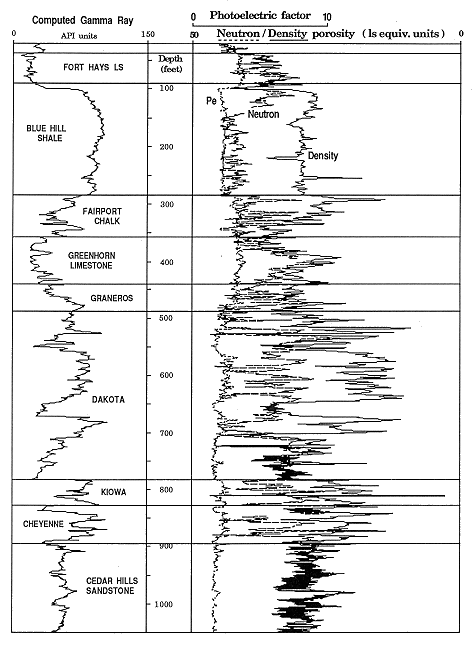
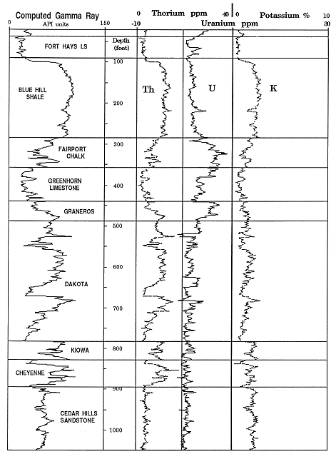
Figure 9. Spectral gamma ray (thorium, uranium, potassium) from KGS #1 Braun, NE,NE,NE Sec 30, T12S, R18W.
Stratigraphic tops of section formations: Interpretation of the character of the log curves was coordinated with the lithologic information from drill cuttings to establish the following stratigraphic tops listed in Table 1.
Table 1. Formation tops in the #1 Braun well, NW, NW, NW Sec. 30, T12S, R18W.
_________________________________________________________
                           DEPTH
FORMATION/MEMBER         TO THE TOP     ELEVATION
NIOBRARA
     Fort Hays Limestone     35           2105
CARLILE SHALE                88           2052
     Blue Hill Shale         90           2050
     Fairport Chalk         284           1856
GREENHORN LIMESTONE         360           1780
GRANEROS SHALE              435           1705
DAKOTA FORMATION            488           1652
KIOWA FORMATION              78           1356
CHEYENNE SANDSTONE          828           1312
CEDAR HILLS SANDSTONE       897           1243

TOTAL DEPTH                1197            943
_________________________________________________________
Summary of petrographic information from published studies: Since
one of the primary objectives of the log analysis in this well was to
make a detailed compositional analysis, a review was made of
published petrographic data from these formations. These data
function as a broad source of "ground truth" which identify the
mineral components to be determined from the logs and their
relative volumetric importance.
The Cedar Hills Sandstone outcrops in Barber County where it consists of red and white feldspathic sandstones, siltstone and silty shale (Zeller, 1968). Holdoway (1978) made a detailed examination of core from a test well in Wichita County and described the composition of the Cedar Hills Sandstone as ranging from quartz arenite to lithic subarkose. The sandstone samples contained quartz grains which were commonly coated with hematite, between 5 and 10 percent fresh feldspars which often showed microcline twinning, small amounts of rock fragments derived from felsic intrusives, opaque minerals, and traces of authigenic clays. The sandstones were unusual in that they were frequently halite cemented. Although Holdoway (1978) made no analyses of clay minerals in the Cedar Hills, James (1972) reported chlorite vermiculite and illite from the insoluble residues of the immediately overlying the Flower-pot Shale.
Merriam et al. (1959) made the most detailed compositional analysis of the Lower Cretaceous formations and Graneros Shale in their study of a lengthy core from Cheyenne County. They found that the matrix of the sandstones was dominantly quartz with traces of feldspar, chert, schist fragments, and detrital tourmaline. The shales of the Lower Cretaceous were mostly a mixture of illite and kaolinite with subsidiary amounts of chlorite, smectite, and mixed-layer clays. Smectite became a major component in the overlying Graneros Shale.
Spectral gamma ray log analysis: Natural gamma radiation in rocks is almost entirely attributable to potassium-40 and the radioactive isotopes of the uranium and thorium families. A conventional gamma ray log records a pooled summation of counts from all radioactive sources. In the design of the spectral tool, "windows" are set to count gamma radiation within specific energy ranges. These measurements are then processed by computer to allocate the total count between the three prime radioactive sources. The gamma ray spectral log is recorded as parallel curves of thorium and uranium which are both scaled in parts per million, together with potassium (see Figure 9). Potassium is logged as a proportion, but is normally converted to percent in log analysis calculations.
The potassium-thorium crossplot is now widely used as an aid in the recognition of clay-mineral associations and the discrimination of micas and feldspars. A crossplot of digitized log data (sampled at the standard rate of two readings per foot) from the Cedar Hills Sandstone, Lower Cretaceous formations, and Graneros Shale is shown in Figure 10 and uses the chartbook crossplot scale conventions (Schlumberger, 1986). The lines which radiate from the origin have gradients matched with values of Th/K ratios and have proved useful in the broad distinction of radioactive minerals marked on the plot.
Figure 10. Thorium-potassium crossplot of Cedar Hills Sandstone, Lower Cretaceous Series, and Graneros Shale, KGS #1 Braun.
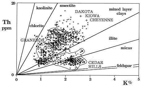
The cluster of points from the Cedar Hills Sandstone is clearly separated from Cretaceous zones and is readily interpreted as a quartz-feldspar-illite system. This aspect conforms very well with the petrography of this unit, described earlier. The Lower Cretaceous zones plot as a broader and more diffuse cloud, as would be expected for a mixed sequence of sandstones, siltstones, and shales. However, the cloud coincides with the kaolinite-smectite-illite range of Th/K ratios which, once again, shows excellent agreement with known petrography. Crossplot data from the Graneros Shale overlaps the Lower Cretaceous points. However, there is distinctive bias towards higher Th/K ratios, which probably reflects the increased importance of smectite as a significant component.
In addition to the thorium-potassium ratio, the thorium-uranium ratio has useful diagnostic properties. In a pioneer paper, Adams and Weaver (1958) concluded that the Th/U ratio was often strongly linked with depositional environment, based on their laboratory analysis of many samples of differing lithologies. They suggested that when the ratio was computed to be less than two (i.e., uranium-rich), the depositional environment had promoted uranium fixation under probable reducing conditions and was most commonly marine. By contrast, ratio values of greater than seven (uranium-poor), implied uranium mobilization through weathering and/or leaching, and therefore indicated an oxidizing, possibly terrestrial environment. Zelt (1985) made gamma ray spectral measurements of Upper Cretaceous outcrops in Colorado, Utah, and New Mexico and showed relationships between the Th/U ratio and transgression-regression cycles as well as inferred distance from shoreline. He found that anomalous ratio values could be correlated regionally between outcrops and on spectral logs from the subsurface and suggested that they were related to major changes in oxygenation and/or salinity in the Western Interior Seaway.
The Th/K and Th/U ratios were plotted as logs in the Braun #1 well together with the gamma ray trace and a graphic lithology log from the description of drill cuttings (Figure 11). The simultaneous consideration of these data throughout the sequence reveals striking and readily interpretable patterns. The long term trend in the Th/K ratio log shows a progressive enrichment of potassium with depth, and probably reflects compactional changes which cause a gradational transition from smectite through mixed-layer clays to illite. An abrupt shift occurs at the Cretaceous-Permian contact and clearly highlights the major basal Cretaceous unconformity. The illite-feldspar signature of the Cedar Hills Sandstone changes to a Lower Cretaceous trace which oscillates between illitic and kaolinitic clay mineral facies, possibly linked with marine and deltaic fresh-water environments, respectively. Fluctuations in the Upper Cretaceous units appear to pick up changes in illite, smectite and mixed layer clays as products of predominantly marine environments, and these are the clay mineral components reported in x-ray diffraction analyses of insoluble residues (Arthur et al., 1985). The high amplitude variations in the Graneros Shale and Greenhorn Limestone may reflect the occurrence of bentonites (observed in the drill cuttings) interbedded with normal illitic marine shales. These bentonites represent altered ash deposits generated by explosive events from volcanoes in the Idaho Montana and New Mexico-Arizona regions (Kauffman, 1985).
Figure 11. Gamma ray, cuttings, lithlog, Th/K, and Th/U from KGS #1 Braun.
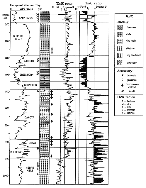
The Th/U ratio log was indexed with the diagnostic values of 2 and 7 suggested by Adams and Weaver (1958) to aid depositional environment interpretation through its use as an oxidation potential indicator. The ratio indicates an oxidizing environment for much of the Cedar Hills Sandstone, which corresponds to its postulated origin as eolian sands (Holdoway, 1978). The occurrence of glauconite in drill cuttings from the upper part of the formation is a strong indicator of marine origin and is matched by a decline in the ratio to a neutral range. This section may reflect deposition in shallow bodies of water linked with an ephemeral sea, as suggested by Holdoway (ibid) for the Flower-pot Shale.
The Cheyenne Sandstone was deposited on an irregularly eroded surface which formed a series of northward-trending valleys in Kansas (Merriam, 1963). The Th/U ratio log exhibits a high frequency character in the Cheyenne, but is consistently higher than seven in value and so is compatible with an oxidizing terrestrial environment of alluvial sediments.
The lower part of the overlying Kiowa Formation marks a transgressive phase and is generally considered to be represented by a marine environment in Kansas (Merriam, ibid). The average Th/U ratio in the Kiowa is lower than in the Cheyenne, but shows only a weak trend to the intermediate range. This feature is a pale shadow of the strong signals in the spectral ratio of Upper Cretaceous transgressions in this well. However, the subdued character is in concordance with a paleogeographic map of peak transgression in the Kiowa (Vuke, 1981), which shows the wellsite close to shoreline. Higher up in the Kiowa, regressive conditions prevailed during deposition (Franks, 1980).
Stacked repetitions of high and medium Th/U ratios characterize the Dakota Formation. These probably reflect high lateral variability in clastic facies and interplay between mostly brackish and fresh-water regimes of distributary channels, bays, and marginal marine deposits, which would be expected to typify a delta complex.
The relatively smooth, long-term cyclic pattern of the Th/U ratio in the marine sequence of the Upper Cretaceous is in stark contrast to the high frequency character of the ratio in the deltaic deposits below and is an excellent indicator of a broad transgression/regression couplet on an open marine shelf. In fact, the broad sine-wave feature conforms precisely with the outcrop interpretation of the Greenhorn Cycle as a classic example of a symmetric, third-order tectonoeustatic cycle (Glenister and Kauffman, 1985). Hattin (1985) was able to correlate demonstrably time-parallel beds in the Greenhorn from outcrops in Kansas to locations in Colorado and New Mexico. He concluded that the exceedingly widespread deposition of relatively thin units implied a regionally flat, gently sloping sea-floor. The model would account for the strong simple transgression-regression signal in the ratio log from the top of the Dakota to the base of the Niobrara. The transgressive phase of the cycle started in the uppermost part of the Dakota Formation, continued through the Graneros Shale, and reached maximum development in the Greenhorn Limestone. The regressive hemicyclothem was initiated at the top of the Greenhorn and continued through the Fairport Chalk and Blue Hills Shale, to terminate in the Codell Sandstone.
There is an abrupt break in the Th/U ratio log at the boundary between the Codell Sandstone and the overlying Fort Hays Limestone. This contact is thought to represent a long period of non-deposition followed by a major transgression (Hattin and Siemers, 1987). The ratio log clearly shows this transgression, but also indicates a distinctive regressive event at the top of the Fort Hays. This anomaly closely coincides with a similar peak on a Th/U log from a Colorado well observed by Zelt (1985), who attributed it to a regional warm water pulse or low salinity event suggested from oxygen isotope studies in the carbonate phase. The Smoky Hills Chalk at the top of the borehole succession is marked by a log ratio feature that indicates renewed transgression.
Lithodensity-neutron log analysis: The spectral gamma ray log analysis indicates generalized clay mineral associations. However, the similarity of potassium and thorium levels of some clay minerals and the multi-clay character of most shales causes ambiguities of interpretation. Consequently, additional diagnostic information from other logs is useful, particularly for detailed work on clay mineral identification and facies recognition within the Lower Cretaceous units.
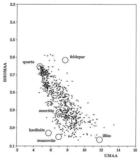
The recent introduction of the photoelectric factor as a supplementary curve to the conventional neutron and density logs has substantially improved the log recognition of mineralogy. The display of lithodensity-neutron logging data on a RHOMAA-UMAA crossplot is the most direct means to ascertain rock compositions from this log combination (McCall and Gardner, 1982). RHOMAA is the hypothetical density of the rock matrix computed as the projection of the rock's bulk density which eliminates the effect of the fluids in the pore space. UMAA is the theoretical volumetric photoelectric absorption index of the matrix, calculated from the photoelectric factor using similar considerations.
A RHOMAA-UMAA crossplot of digitized data from the Lower Cretaceous formations is shown in Figure 12. This plot is indexed with the approximate locations of clay minerals which, in reality, show ranges of variability as a consequence of differing compositions and morphologies. The cloud of points shows a distinctive wedge pattern whose upper vertex is sited at the coordinates of quartz. The wedge ranges between "low-Z clays" (kaolinite, smectite, and muscovite) and "high-Z clays" (illite and chlorite) and can reasonably be represented by a composition triangle. Any zone point may then be recast as proportions of the three end members.
Figure 12. RHOMAA-UMAA crossplot of Lower Cretaceous (Cheyenne, Kiowa, Dakota) in KGS #1 Braun.
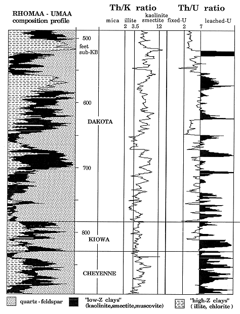
The RHOMAA-UMAA data for the Lower Cretaceous were transformed to proportional logs of these three components by a matrix algebra computer algorithm described by Doveton (1986). The result is shown in Figure 13, together with thorium-potassium and thorium-uranium ratio logs. Comparison of the three sets of curves will be the basis for detailed analysis of the entire Lower Cretaceous. This will extend beyond mineral characterization to the subdivision of clastic facies and depositional environments. The analysis should provide important information for use in lateral correlation and clues to the likely shapes and trends of individual sandstone bodies, which will be useful in three-dimensional modelling.
Figure 13. Composition profile of Lower Cretaceous formations based on RHOMAA-UMAA plot parameters, together with GR spectral ratios in KGS #1 Braun.
Previous page--Stratigraphy ||
Next page--Geologic Structure
Start of Report ||
Report Contents