


Kansas Geological Survey, Open-file Report 88-39
Great Plains and Cedar Hills Aquifers--Page 7 of 25
Figure 14. Configuration of the top of the Dakota Formation in the study area.
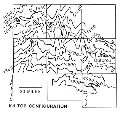
These changes of dip in the near surface rocks reflect the boundary between the Central Kansas uplift and the Cambridge arch in the eastern and central portions of the study area and the Western Kansas basin in the western part. The Central Kansas uplift is a large uplifted and eroded structural feature covering most of the study area. Its development was largely completed by the end of the Pennsylvanian (Merriam, 1963). However, the Western Kansas basin is a feature that developed during the Mesozoic and was tilted to the northwest with the development of the Denver basin in eastern Colorado and southwestern Nebraska (Merriam, ibid).
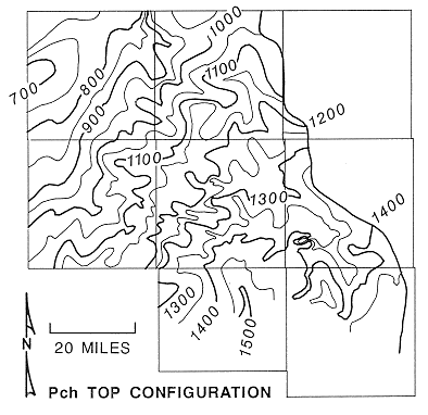
Figure 15. Configuration of the top of the Cedar Hills Sandstone in the study area.
Many minor structures are present in the surface rocks and are reflected in the configuration of the top of the Dakota Formation. The Fairport-Natoma anticline is a north-south feature located along the Ellis-Russell County line. The east-west oriented Pfeifer anticline is located near the southern end of the Fairport-Natoma anticline. Both features are located on the crest of the Central Kansas uplift and appear in the deeper Paleozoic and Precambrian rocks as complex, elongate, fault-bounded uplifts. Another structural feature that shows up particularly well in the near-surface rocks is the north-south trending Stockton anticline located in Rooks and Ellis counties in R19W. Many smaller named and un-named structures are also present in the study area, such as the Wakeeney anticline in T11S, R23W, Trego County. An extensive un-named structural low is also present in T8S, R24-25W. This structure is also present on Merriam's (1963) top configuration maps of the Carlile Shale, Dakota Formation, and Stone Corral Formation.
Faults are present at the surface in association with the Niobrara Formation throughout the western part of the study area. In an early reconnaissance of the geology of Ellis County, Bass (1926) mapped 76 occurrences of surface faulting in the Smoky Hill Chalk Member in T12S, R20W. Later work by Merriam (1963) shows that these faults are probably not related to regional structure.
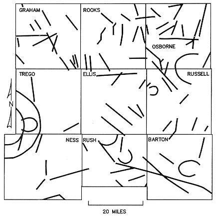
Occurrences of faulting or jointing of the exposed bedrock can be seen or implied from the analysis remote sensing images of the land surface. Shown in Figure 16 is a preliminary map showing the occurrence of remote sensing lineaments in the study area and the adjacent Ness County (McCauley, 1985). This map shows that the jointing of the near-surface rocks follows the NW-SE trend of the Central Kansas uplift in the study area and the predominant trend of the Precambrian bedrock surface (Cole, 1976). A weaker NE-SW lineament trend is present in western Graham County that but is much more pronounced farther west in Sheridan and Thomas counties. This trend is parallel to the strike of the Precambrian bedrock surface in the Western Kansas basin and approximately perpendicular to the trend of the Central Kansas uplift. None of the lineaments found at the surface coincide with known faults in the Precambrian.
Figure 16. Remote-sensing lineaments in the study area. Adapted from unpublished work by McCauley (1985).
Previous page--Log Analysis ||
Next page--Regional Aquifers
Start of Report ||
Report Contents