


Kansas Geological Survey, Open-file Report 88-39
Great Plains and Cedar Hills Aquifers--Page 5 of 25
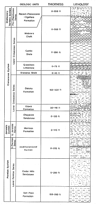
Described below are the geologic units that occur at the surface or in the shallow subsurface of the study area above the Harper Formation (Lower Permian). Figure 3 shows the time-stratigraphic and rock- stratigraphic classification of these rocks adapted from Zeller (1968) with the expected range in thickness and lithologies represented in graphic form. Maps showing the top and thickness of the Dakota Formation, thickness of strata belonging to the Kiowa Formation and Cheyenne Sandstone, extent and thickness of strata from the base of the Cretaceous to the top of the Lower Permian Cedar Hills Sandstone, and the extent and thickness of Cedar Hills Sandstone are included in this report as Figures 4-7, 14 and 15.
Figure 3. Stratigraphic column of the near-surface rock units in the study area.
Recent-Pleistocene-Ogallala Formation: Sedimentary deposits of Recent and Pleistocene age consist of unconsolidated gravels, sands, silts, and clays. These materials make up the alluvium and older terrace deposits found in the stream valleys of the study area. Terrace deposits composed of Pleistocene-age materials are well-developed in the Smoky Hill, Saline, and Solomon River valleys (Frye and Leonard, 1952). Loess mantles many of the stream divides in the study area. Much of the land surface of Graham, northern Trego, and northern Ellis Counties is mantled by the eroded remnants of the Ogallala Formation. In western Graham County the Ogallala is as much 250 feet thick. At the Hays North monitoring site, which is located on an upland, approximately 35 feet of residual Ogallala Formation is present.
Niobrara Chalk: This formation crops out in a northwesterly trending belt and underlies the northwest one-half of the study area. The Niobrara Chalk consists of an upper member, the Smoky Hill Chalk, and a lower member, the Fort Hays Limestone. Interbedded shale, thin seams of bentonite, shaley chalk, and chalk comprise the Smoky Hill Chalk Member. The thickness of this member ranges up to a maximum of 440 feet in Graham County. The Fort Hays Limestone Member consists of massive chalk beds separated by thin beds of chalky shale. The thickness of the Fort Hays, where it has not been eroded, is fairly uniform and ranges from 55 to 65 feet.
Carlile Shale: The Carlile Shale consists of the Codell Sandstone Member, the Blue Hill Shale Member, and the Fairport Chalk Members. This formation is exposed throughout much of the study area in eroded slopes, stream valleys, and canyons cut through the Fort Hays Limestone Member and east of the Fort Hays escarpment. Where the unit has not been partially eroded, the thickness of Carlile Shale ranges from 260 to 280 feet. The Codell Sandstone consists of heavily bioturbated and reworked sandy siltstone and very fine-grained calcareous sandstone. Along the outcrop, the Codell is locally not present. However, gamma-ray logs of the interval show that the Codell is usually well-developed in the subsurface. The top of the Codell is separated from the overlying Niobrara Chalk by a non-depositional or erosional surface of little local relief. The base of the Codell is gradational with the underlying Blue Hill Shale Member. Thickness of the Codell ranges up to five feet within the study area. The Blue Hill Shale Member consists of dark gray shale, silty near the top, with numerous zones of calcareous concretions. The Blue Hill Shale Member grades downward into the Fairport Chalk Member. The Fairport consists of beds of chalky to marly shale interbedded with chalky limestone and marlstone in the middle and upper parts of the section and chalky limestone in the lower part. This unit grades downward into the underlying Greenhorn Limestone.
Greenhorn Limestone: This formation is composed of thin-bedded chalky limestone and calcareous shale. The Greenhorn Limestone is present at the surface in much of the southeastern part of the study area and has been subdivided into the Pfeifer Shale, Jetmore Chalk, Hartland Shale, and Lincoln Limestone Members. The thickness of the Greenhorn Formation in the subsurface is generally 70 to 75 feet. The contact separating the Greenhorn Limestone from the Graneros Shale is one of non-deposition and local erosion (Hattin, 1978).
Graneros Shale: The Graneros Shale consists mostly of fissile, non-calcareous, gray to dark gray shale. Thin beds of cross-laminated, fossiliferous, well-sorted sandstone are locally developed. Thin seams of bentonite are quite common throughout this formation. A particularly well-developed bentonite bed is found near the top of the Graneros and has been named the "X" bentonite by Hattin (1965). The thickness of this bentonite layer ranges up to approximately one foot locally. The "X" bentonite is present along much of the Graneros outcrop in central and southern Kansas and has been used as a stratigraphic marker by Siemers (1971, 1976).
Dakota Formation: The Dakota Formation consists of floodplain deposits of interbedded siltstone, claystone, thin-bedded sandstone and lignites; lenticular, (fluvial or distributary) channel sandstones; and delta front sandstones (Franks, 1975; Siemers, 1971). Plummer and Romary (1942) have divided the Dakota Formation into two members, the Jansen Clay Member (upper) and the Terra Cotta Clay Member (lower). The Janssen is dominated by gray to dark gray, kaolinitic clay rocks, interbedded lignite and sandstone. The Terra Cotta Clay Member is composed of kaolinitic clay rocks that are light gray to light greenish gray. In the subsurface of Kansas these members of the Dakota Formation have not been recognized (Franks, 1975). Both members contain well-developed lenticular channel sandstone bodies.
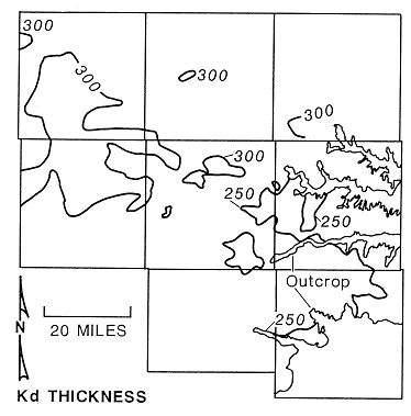
Well-developed channel sandstones--the Rocktown Channel Sandstone (Rubey and Bass,1925)--and associated tabular, flat-bedded, delta front sandstones can be found near the top of the Dakota Formation in Russell County (Siemers, 1971, 1976). The Dakota Formation is present at the surface in much of Russell and Barton counties and portions of eastern Rush, southeastern Ellis, and southern Osborne counties and the formation is present in the subsurface west of the outcrop belt. Where uneroded, the thickness of this formation ranges from 200 to 310 feet across the study area (Figure 4). The Dakota appears to be thinnest in Russell and eastern Barton counties and thickest in the northern half of Trego and the southern half of Graham counties. The Dakota appears to rapidly thicken from less than 225 feet to more than 275 feet in eastern Ellis County. Over most of the study area, the thickness of the Dakota Formation ranges from 275 to 300 feet.
Figure 4. Thickness of the Dakota Formation in the study area.
Kiowa Formation and Cheyenne Sandstone:The Kiowa Formation consists of largely of gray, clay shales and siltstones containing illite and smectite clays interbedded with thin, sheet-like and thick, lenticular sandstones (Franks, 1965, 1975). Most of the sandstone is very fine grained, well sorted, well rounded, and quartzose, and contains abundant flakes of muscovite. Farther east where the Kiowa is at the surface, Franks (1975) reports that the grain size of the clastics that comprise the thick lenticular sands ranges from medium to conglomeratic. Charcoal and beds of fossiliferous limestone are common in this unit. The Cheyenne Sandstone consists of brownish gray to light gray or white shales and siltstones interbedded with fine-grained sandstones and fine to coarse-grained conglomeratic sandstones. Typically, sandstones lower in the section, near the top of the Permian contain frosted, well-rounded, fine to medium-grained sand derived from the underlying Permian. Similarly, well-rounded, frosted grains are also found in the Kiowa where the unit directly overlies the Permian. The clays that make up the shales and siltstones tend to be kaolinitic and smectitic (Franks, 1975).
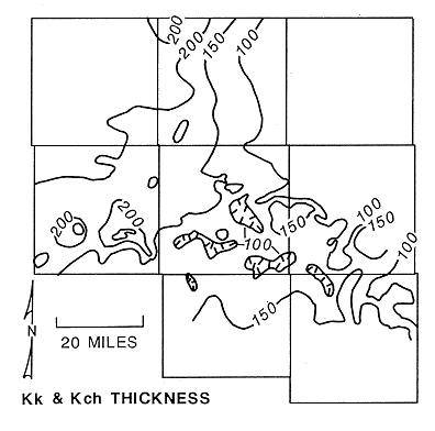
The Kiowa Formation and the Cheyenne Sandstone have been grouped together for the purposes of this report for two reasons. Firstly, Franks (1975, 1980) and Scott (1970) believe that the Cheyenne Sandstone has been miscorrelated with the lower part of the Kiowa Formation in the subsurface. They note that the lower part of the Kiowa, the "Longford member" of Franks (1965), is composed of many of the same lithologies that occur in the Cheyenne. However, these units are not time equivalent. The difficulty of distinguishing between the Kiowa and Cheyenne is also noted by Swineford and Williams (1945). They found that in Russell County a distinction between units could be made based only on the presence of micaceous, glauconitic sandstones and siltstones, marine shell fragments, or the presence of red ironstone and impure hematite. Secondly, an examination of well logs and cuttings suggests that these rocks appear to have the same porous media properties. As a result, the Kiowa Formation and the Cheyenne Sandstone probably behave hydrologically as a single unit (a hydrostratigraphic unit) in the study area. Thickness of the combined Kiowa Formation and Cheyenne Sandstone ranges from less than 100 to more than 250 feet (Figure 5).
Figure 5. Thickness of strata belonging to the Kiowa Formation and Cheyenne Sandstone in the study area.
Morrison Formation: The Morrison Formation consists of interbedded shales, siltstones, and sandstones, and, near the base of the formation, some lenticular channel sandstones. The lenticular sandstones range up to fifty feet in thickness in southeastern Trego County and are of fluvial origin (Merriam, 1963). The interbedded shales and siltstones appear to contain relatively high concentrations of radioactive elements based on the gamma ray logging response. The Morrison is thought to be present in the subsurface of most of Graham, western and southern Trego, and northwest Rush Counties. Eastward of this area the Morrison has been removed by pre-Cretaceous erosion. The Morrison is separated from the underlying Permian formations by a regional unconformity.
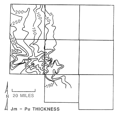
Undifferentiated Permian: The Undifferentiated Permian is composed of strata belonging to the Whitehorse and Blaine Formations, and the Flower-pot Shale. In the study area, the Whitehorse and the Flower-pot consist of red to brown evaporitic shales and siltstones and minor sandstones. The Blaine Formation consists entirely of anhydritic gypsum or anhydrite in the study area (Merriam, 1963). Where present, the thickness of the Blaine is approximately 10 to 15 feet and shows a pronounced response on gamma ray-neutron logs. The thickness of strata belonging to the Morrison Formation and the undifferentiated Permian ranges from featheredge at the eastern extent to more than 350 feet in southwest Trego County (Figure 6). The undifferentiated Permian is truncated by pre-Cretaceous erosion eastward of R19W.
Figure 6. Thickness of strata between the top of the Cedar Hills Sandstone and the base of the Cheyenne in the study area.
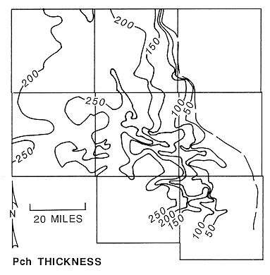
Cedar Hills Sandstone: The Cedar Hills Sandstone consists of red sandstone and interbedded sandy siltstone and shale (Swineford, 1955). The sandstones are composed largely of well-rounded, frosted, fine to medium-grained quartzose sands with feldspar as the most important minor constituent. Grains of sand are frequently iron-stained with hematite. Individual beds of shale in the Cedar Hills are 15 to 30 feet thick and can be traced for 10 to 20 miles in the subsurface. Thickness of the Cedar Hills ranges from featheredge at its eastern extent to more than 275 feet in northwestern Trego County (Figure 7). Eastward of R19W, younger Permian and Jurassic rocks have been truncated by pre-Cretaceous erosion and the Cedar Hills underlies the Lower Cretaceous in much of Ellis and western Russell counties.
Figure 7. Thickness of the Cedar Hills Sandstone in the study area.
Salt Plain Formation: The Salt Plain Formation is composed largely of red silty shale. Minor sandstone and sandy siltstone are locally developed just below the base of the Cedar Hills Sandstone.
Previous page--Methods of Study ||
Next page--Log Analysis
Start of Report ||
Report Contents