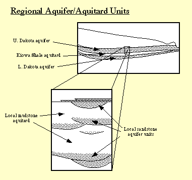
Figure 1
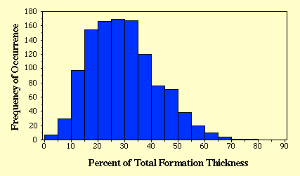
The proportion of sandstone to the total thickness of the stratigraphic units that constitute the Dakota aquifer is approximately 30% statewide. However, locally this proportion can vary widely from less than 5% to more than 50% over short distances. For example, 1,131 gamma-ray logs of oil wells were examined to determine the variation in the proportion of sandstone to total thickness of the Dakota Formation sampled by these boreholes in a 12-township area (432 square mi) of southwestern Ellis County. Figure 2 is a histogram showing the frequency of occurrence of sandstone in the Dakota Formation from the logs. The histogram shows that the amount of sandstone penetrated in the formation by boreholes drilled for oil and gas ranges widely from 3% to 78%. The average amount of sandstone penetrated was 29%. The average thickness of the Dakota Formation within the study area is 282 ft. This means the average total footage of sandstone encountered is approximately 82 ft. However, assuming an average formation thickness, slightly more than two-thirds of the 1,131 wells encountered between 16% and 42% sandstone or a total thickness of 45 ft. and 118 ft. respectively.
Figure 2
The high variability of the Dakota aquifer framework underscores the need to define hydostratigraphic units within the aquifer on basis of the scale and nature of the questions being asked (Figure 1). The aquifer/aquitard units defined at the regional scale would not be appropriate at the scale of the well field or well site, where the required level of detail in the results is much higher. At the local scale, perturbations of the flow field over some finite time period cause transient flow conditions in the vicinity of the well field or pumping well, and these propagate through the aquifer for some distance, mainly through the more permeable sandstones (Macfarlane et al., 1993). Thus the local hydrostratigraphy consists of sandstone aquifers confined within mudstone aquitards. The geometry of the sandstone bodies and their hydraulic properties become relatively important influences on ground-water flow that need to be evaluated to resolve issues related to the effect of withdrawals on the flow system. Regional subdivision of the deposits within the Dakota into sequences is useful for correlating and mapping discontinuous fluvial and deltaic/estuarine sandstone bodies in the subsurface, which are the local sources of water for pumping wells.
Previous Page--Hydrostratigraphy ||
Next Page--Steady-state regional flow systems
Dakota Home ||
Start of Report