To define the pattern of moving ground water in a flow system, hydrogeologists use measurements of water-level elevation taken in wells scattered throughout the aquifer system. In most cases, the water-level elevation equals the hydraulic head in a well. The hydraulic head at any point in the flow system is a measure of the potential energy per unit weight of ground water at that point (Freeze and Cherry, 1979). The movement of ground water involves a loss of energy and is similar to the flow of water in river systems. Water naturally flows downhill from elevated regions of the continent (higher hydraulic head) to the sea (lower hydraulic head). In much the same way ground water moves from points of higher hydraulic head to points of lower hydraulic head in a flow system. Most of the hydraulic head data used to define the flow system come from the aquifer units. In a confined aquifer the hydraulic head is above the top of the aquifer unit whereas in an unconfined or water table aquifer unit, the hydraulic head is within the unit. Hydraulic head data are typically unavailable for the aquitard units. As a result, ground-water flow across the aquitards must be inferred from hydraulic head measurements in the adjacent aquifer units.
Due to its great thickness and extremely low permeability in the Denver basin of eastern Colorado, the Upper Cretaceous aquitard hydrologically isolates the flow system in the Dakota from the overlying water table. The aquitard is as much as 10,000 ft. thick in the deepest part of the basin adjacent to the Front Range of the Rocky Mountains. Here, the hydraulic heads in the Dakota aquifer are more than 2,500 ft lower than the elevation of the overlying water table (Figure 1). An aquifer is usually considered in good hydraulic communication with the overlying water table if there are only small head differences between them. The regional flow models of Belitz (1985) and Helgeson et al. (1993) have shown that the aquitard restricts the downward movement of recharge to the Dakota to near negligible levels.
Figure 1. The hydraulic head difference between the Dakota aquifer and the overlying water table in the Denver basin and adjacent areas to the east. Modified from Helgesen et al. (1993).
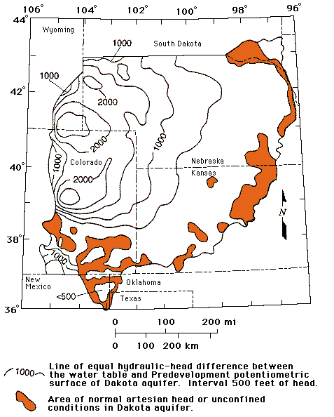
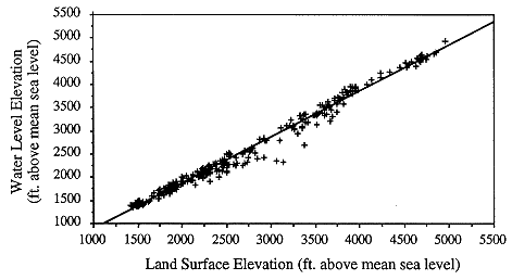
However, away from the basin center in Kansas and southeastern Colorado, the Upper Cretaceous aquitard thins from more than 2,000 ft in northwest Kansas toward its extent in central and southwestern Kansas. As a result, its control on the flow system in the Dakota aquifer diminishes toward the outcrop/subcrop belt. Within the last 10 million years, differential uplift and intense local dissection of the High Plains surface have created considerable local and regional topographic relief. Incisement is a common feature of the drainage in the Arkansas River basin in southeastern Colorado, and southern Kansas and the Smoky Hill, Saline, and Solomon River systems in north-central Kansas. Many of these river systems have cut down through the aquitard and into the geologic units that constitute the Dakota aquifer system. Consequently, the head difference between the Dakota and the overlying water table is less than 1,000 ft. in most of western and central Kansas and southeastern Colorado where the confined aquifer is relatively shallow (Figure 1). Here, local topographic relief is an important influence on ground-water flow in the Dakota aquifer (Figure 2).
Figure 2. Water-level elevation vs. land-surface elevation in the confined Dakota aquifer, southeastern Colorado and western and central Kansas. The slope of the best-fit line from regression is 0.993, which is significant (p = 0.001). The larger negative deviations of the data from the fitted line indicate the greater influence of the Upper Cretaceous aquitard on the flow system between 3,000 ft. and 3,700 ft. land surface elevation.
Geologic processes have also played an active role in changing the boundary conditions of the flow field and the hydraulic properties and composition of the hydrostratigraphic framework (Kreitler, 1989). Periods of deposition, erosion, and tectonic activity associated with the Laramide Orogeny at the close of the Cretaceous Period and cycles of erosion and deposition that occurred in the Quaternary have undoubtedly induced significant changes in the flow system over time. These geologic processes would have changed the elevation and configuration of the regional water table and pore pressures in low permeability porous media. As a result, it is possible that an overprint of a more recent flow system on an older one is being maintained while the regional system is adjusting to a new steady-state condition. However, it is believed that if the flow system is still adjusting to a new equilibrium configuration, the changes in hydraulic head caused by the adjustments are relatively minor in comparison to the large hydraulic head differences in the aquifer systems between eastern Colorado and central Kansas.
Previous Page--Local units ||
Next Page--Dakota Flow
Dakota Home ||
Start of Report