Table 1 also shows the equivalent stratigraphic units in eastern Colorado. The combined thickness of these units can range up to more than 700 ft in west-central parts of the state. However, not all of the units that constitute the Dakota contain aquifer-grade material that can yield water to wells.
The amount of sandstone, considered to be the aquifer material, varies from less than 5% to more than 50% of the total thickness, even over distances of less than a mile. More information on the stratigraphy of these deposits can be found on this volume of the CD set in the Geologic Framework directory.
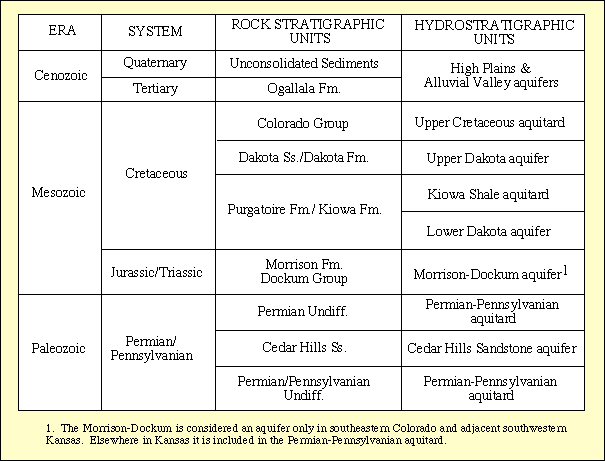
Table 1
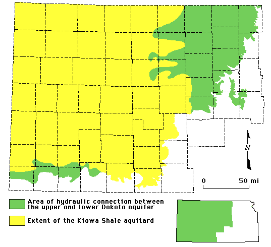
At the regional scale, the Dakota aquifer system consists of upper and lower units (Table 1; Figure 1). The upper aquifer unit consists entirely of the Dakota Formation and the shoreline deposits at the top of the Kiowa Formation and is approximately 300 ft thick. The lower aquifer unit consists of the Longford Member of the Kiowa Formation and the Cheyenne Sandstone and varies considerably in thickness up to 200 ft. These upper and lower regional aquifers are separated in western and parts of central Kansas by thick, marine shale in the Kiowa Formation, referred to as the Kiowa shale aquitard (Table 1). The thickness of the aquitard ranges up to more than 300 ft in parts of west-central and southwestern Kansas. The Kiowa shale aquitard is not present in much of central Kansas where it has been removed by erosion or was not deposited. Where it is not present the potential exists for direct hydraulic connection between the upper and lower Dakota aquifer. Figure 2 shows the extent of the Kiowa shale aquitard in Kansas.
Figure 1
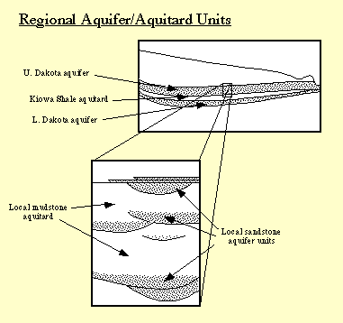
Figure 2--Extent of the Kiowa shale aquitard in Kansas.
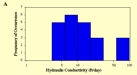
Twenty-two reliable values of hydraulic conductivity from field hydraulic tests of wells in the Dakota aquifer of Kansas were found in the literature or were derived from field tests conducted for the Dakota Aquifer Program. Most of the values come from pumping tests where the Dakota aquifer is shallow in central and southwestern Kansas. The hydraulic conductivity data from the field hydraulic testing range from 3.6-88 ft./day with a geometric mean value of 12.5 ft/day (Figure 3A). The highest hydraulic conductivities are generally found in the outcrop or near the outcrop areas of the Dakota aquifer in central Kansas and the lowest values in southwestern Kansas.
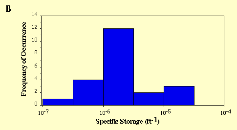
Figure 3. Distribution of hydraulic conductivity (A) and specific storage (B) values from 22 pumping tests of the Dakota Aquifer in Kansas.
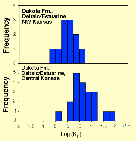
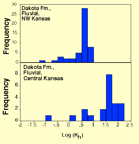
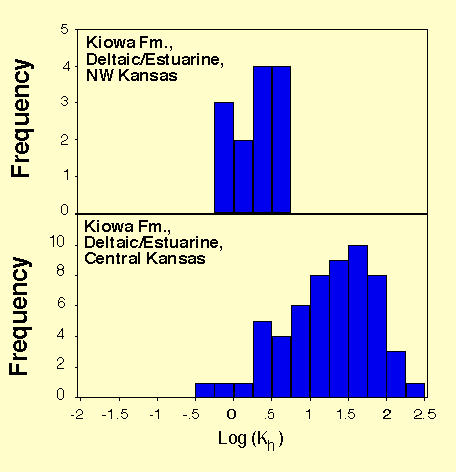
In Figure 4 similar trends can be observed in the results from lab tests on core samples of the sandstones from the Dakota aquifer in central and northwest Kansas. Core samples of sandstone from central Kansas appear to be more permeable than core samples of sandstone from northwest Kansas. The test results suggest that hydraulic conductivity is generally highest in the better sorted and coarser sandstones. These sandstones are most common in the lower sections of thick, amalgamated, multi-story fluvial- and distributary-channel sandstone bodies found in central Kansas.
Figure 4. Histograms of horizontal hydraulic conductivity of fluvial and shoreface sandstones from the Dakota and Kiowa Formations in the KGS #1 Jones (central Kansas) and the #1 Beaumeister (northwestern Kansas).
Direct field or laboratory tests on the mudstone matrix were not conducted in the Dakota Aquifer Program. However, Wade (1991, 1992) reported a mudstone vertical hydraulic conductivity of 2.2 ± 0.6 x 10⁻³ft./day from a pumping test of a thick sandstone aquifer in Washington County. Macfarlane et al. (1994) concluded from analysis of a pumping test near the outcrop in central Kansas, that the vertical hydraulic conductivity of the mudstone is considerably less than 0.001 ft/day, perhaps by several orders of magnitude. These results suggest that processes associated with erosion and unloading of the Dakota aquifer sediments may significantly increase the bulk vertical hydraulic conductivity of the mudstone matrix that surrounds the sandstone bodies of the Dakota aquifer.
The release of water from storage in confined aquifers is analogous to the process of consolidation in soil mechanics. Water is released from storage by (1) the expansion of water under confinement due to the decrease in fluid pressure to atmospheric, and (2) the consolidation of the confined aquifer framework due to the release of water. These two phenomena are expressed jointly in the specific storage term:
 (eqn. 1)
Where  is the water density (mass
per cubic liter), g is the acceleration of gravity
(length per square of time), and
is the water density (mass
per cubic liter), g is the acceleration of gravity
(length per square of time), and  and
and  are the compressibilities of
the aquifer framework and the water, respectively (length multiplied by
time squared divided by mass). In eqn. 3 the expansion of the
framework is reflected in and
that of the water is reflected in the
are the compressibilities of
the aquifer framework and the water, respectively (length multiplied by
time squared divided by mass). In eqn. 3 the expansion of the
framework is reflected in and
that of the water is reflected in the
 term. In most cases the consolidation of the aquifer framework is most
important influence on the specific storage. The storativity is the product
of the specific storage and the thickness of the sandstone aquifer.
term. In most cases the consolidation of the aquifer framework is most
important influence on the specific storage. The storativity is the product
of the specific storage and the thickness of the sandstone aquifer.
Twenty-two reliable values of specific storage from field hydraulic tests of wells in the Dakota aquifer of Kansas were found in the literature or were derived from field tests conducted for the Dakota Aquifer Program. Most of the values come from pumping tests where the Dakota aquifer is shallow in central and southwestern Kansas. Values of specific storage range from 1.5 x 10⁻⁷ (inverse feet) up to 2.9 x 10⁻⁵ (inverse feet), which is within the expected range of values for confined sandstone aquifers. In Figure 2B the data appear to be log normally distributed with a geometric mean of 2.1 x 10⁻⁶ (inverse feet).
Previous Page--Other significant units ||
Next Page--Local units
Dakota Home ||
Start of Report