Kansas Geological Survey, Educational Series 6, originally published in 1988
Back to Maps...
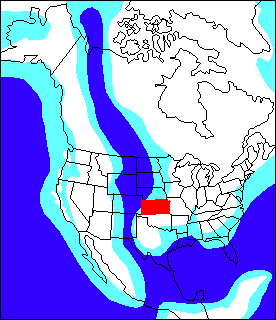
Figure 47. The white area shows land that was above water during the Cretaceous Period and the blue areas are the sea (modified from paleogeographic map of North America as it was in mid-Cretaceous time in Historical Geology by Carol O. Dunbar, 1964, John Wiley and Sons).
Kansas Geological Survey
Placed on web Feb 11, 2016; originally published 1988, reprinted 1995.
Comments to webadmin@kgs.ku.edu
The URL for this page is http://www.kgs.ku.edu/Publications/Bulletins/ED4/fig47.html