Kansas Geological Survey, Public Information Circular (PIC) 8
Next Page--Water-supply-suitability Areas
![]()
![]()
![]()
Kansas Geological Survey, Public Information Circular (PIC) 8
Next Page--Water-supply-suitability Areas
P. Allen Macfarlane
In many areas of western and central Kansas, the water in shallow aquifers and at the surface will be inadequate to meet future demands. Because the only other available source of water for these areas is the Dakota aquifer, proactive management plans must be formulated to prevent overdevelopment. [Bold terms defined in Glassary at end of paper.]
The Dakota is a highly variable aquifer system in Kansas. Some parts of the aquifer contain abundant quantities of freshwater at shallow depths. Elsewhere, the aquifer is much deeper in the subsurface and may contain unusable ground water with salinities (the sum of the dissolved constituents in the water) that exceed 10,000 mg/L. In some areas, well pumping in the Dakota may allow saltwater to move upward into shallower, fresher aquifers or induce freshwater recharge into the Dakota from other aquifers. In other areas, ground-water withdrawals may cause the eventual depletion of the aquifer. To insure the Dakota's continued use, management decisions must take into account this high degree of natural variability and the variable response of the aquifer system to pumping.
From our research, the Kansas Geological Survey (KGS) proposes the recognition of distinct water-supply-suitability areas in the Dakota aquifer based on local conditions in the aquifer or its response to pumping by wells. This circular provides information on these proposed suitability areas, information that groundwater management districts, basin advisory councils, state water agencies, and others may find useful in the development of water-management plans and policies for the Dakota aquifer in Kansas. The italicized boldface terms are defined in the Glossary at the end of this publication.
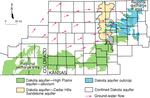
The Dakota aquifer system underlies much of the western two-thirds of Kansas (fig. 1) and consists of sandstone bodies interspersed in relatively impervious shales.
Figure 1--Map showing the confined and unconfined regions of the Dakota aquifer in Kansas and regions of hydraulic connection with other aquifer systems. Arrows indicate the directions of ground-water flow through the confined Dakota aquifer from the regional recharge to the discharge area.
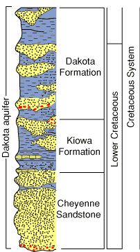
These sandstones and shales belong to the Cheyenne Sandstone, Kiowa Formation, and Dakota Formation (fig. 2). In western and parts of central Kansas, the Dakota aquifer system is separated into upper and lower aquifers by a relatively impervious shale unit within the Kiowa Formation, the Kiowa shale aquitard. The upper Dakota aquifer consists of sandstones in the Dakota Formation. The lower Dakota aquifer consists of the sandstones in the lower part of the Kiowa Formation and the Cheyenne Sandstone. In much of central Kansas, the Kiowa shale aquitard is not present and the upper and lower aquifer units in the Dakota are not recognized.
Figure 2--Geologic units and the major subdivisions of the Dakota aquifer in western and central Kansas.
Over most of its extent in Kansas, the Dakota is overlain by a relatively impermeable sequence of younger shale and chalk units that form the Upper Cretaceous aquitard. Where this aquitard is present, the Dakota is a confined aquifer. In most of the confined Dakota aquifer in Kansas (fig. 1), ground water moves very slowly from recharge areas in southeastern Colorado to discharge areas in central Kansas. Freshwater recharge from overlying sources is negligible in northwest Kansas where the Upper Cretaceous aquitard is more than 2,000 feet (610 m) thick. Consequently, ground-water salinity in the Dakota of northwest Kansas exceeds 10,000 mg/L (fig. 3).
Figure 3--Map showing salinity, the sum of the dissolved constituents, of ground water in the upper Dakota aquifer in western and central Kansas. Water containing less than 1,000 mg/L is defined as fresh. Water with 1,000-2,000 mg/L is usable for many purposes but is less desirable than freshwater. A concentration of 10,000 mg/L is defined in the state regulations of the Kansas Corporation Commission as the upper limit of usable water; above 10,000 mg/L a water is classified as unusable or mineralized..
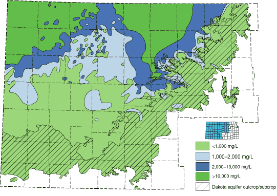
In central Kansas, the Upper Cretaceous aquitard thins, and recharge to the Dakota from overlying sources is significant. However, in the confined part of the Dakota where it is hydraulically connected to the underlying Cedar Hills Sandstone in north-central Kansas (fig. 1), ground-water salinities in the upper Dakota generally exceed 10,000 mg/L (fig. 3).
Elsewhere, the Dakota is an unconfined aquifer (fig. 1). Recharge is locally derived from infiltrating precipitation and is estimated to be at most a few tenths of an inch per year. In most of the unconfined aquifer, ground water in the upper part of the Dakota aquifer is fresh (fig. 3), but the salinity of ground water may increase with depth locally in the lower part of the aquifer. Ground water is discharged from the unconfined Dakota to nearby streams through fresh- and saltwater springs, seeps, and marshes. During periods of low streamflow, saltwater becomes a major component of the discharge to some of the streams in central Kansas, such as the Saline River. In southwestern and south-central Kansas, the Dakota is hydraulically connected to the High Plains aquifer (fig. 1). The High Plains aquifer consists of the Ogallala Formation and associated aquifers in Pleistocene and Holocene deposits. Ground water moves easterly from the regional recharge area in southeastern Colorado into southwestern Kansas and discharges to the overlying High Plains aquifer near the Kansas-Colorado border. Further east, the High Plains aquifer recharges the Dakota in Gray and northern Meade counties.
Next Page--Water-supply-suitability Areas
Kansas Geological Survey, Public Outreach
Web version June 1997
http://www.kgs.ku.edu/Publications/pic8/pic8_1.html