Kansas Geological Survey, Public Information Circular (PIC) 20
Next Page--Townships and Sections
![]()
![]()
![]()
Kansas Geological Survey, Public Information Circular (PIC) 20
Next Page--Townships and Sections
Daniel R. Suchy
If you have ever had to identify the legal location assigned to a particular piece of land--that is, the section, township, and range, and smaller divisions--then you have encountered the Public Land Survey System. The Public Land Survey System was established by the United States government to locate, describe, and record parcels of land for legal purposes. In this system, land is surveyed in a north-south, east-west rectangular grid and divided into townships that are generally 6 miles on a side and contain 36 sections that are each about 1 mile square and contain 640 acres. This system is in effect in Kansas. This publication is designed to provide a basic understanding of the Public Land Survey System and how to use it.
The U.S. Public Land Survey System (PLSS) became official government policy shortly after the Revolutionary War, with the passing of the Land Ordinance of 1785. This ordinance grew out of a political movement led by Thomas Jefferson and John Adams that held that an essential part of a democracy was the right to own property. They argued that the land should not be given out in large grants to wealthy men and land speculation companies, but rather that it should be divided into small parcels and sold for low prices to make it possible for the common man to own land. This ordinance set up a standardized national survey system that incorporated the better features of the systems previously used by the colonies, particularly the New England colonies in which "towns" were laid out in rectangles 6 to 10 miles square that were then divided into individual parcels. The first land to be surveyed under the 1785 ordinance was in southeastern Ohio, adjacent to the western boundary of Pennsylvania. The PLSS eventually included all of the U.S. westward from Ohio to the Pacific Ocean and northward to the Arctic.
The PLSS was extended into Kansas by the Act of July 22, 1854, which established the office of the Surveyor General for the territories of Kansas and Nebraska. The first person to fill that position, John Calhoun, set up his office in Fort Leavenworth, Kansas Territory, in 1854. He was instructed to survey the parallel of 40° North latitude, as a baseline for the survey, from the Missouri River westward for a distance of 108 miles, or 18 townships, where the initial point of the Sixth Principal Meridian was to be established (fig. 1).
Figure 1--Map of township and range lines in Kansas. Townships are numbered 1 to 35 from the Nebraska state line on the north to the Oklahoma state line on the south. Ranges are numbered 1 to 25 east from the Sixth Principal Meridian, and 1 to 43 west from the Sixth Principal Meridian.
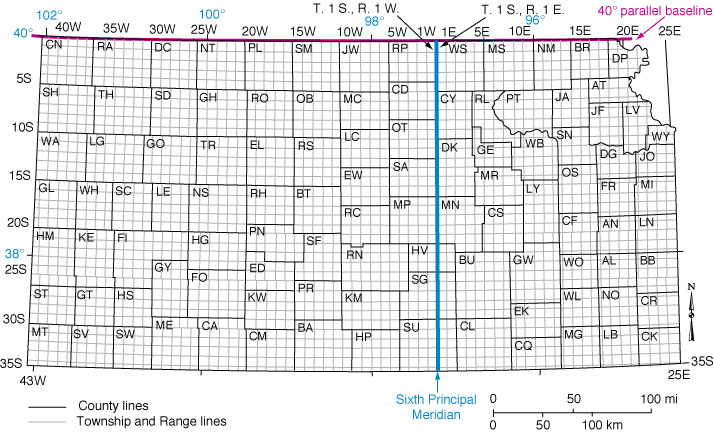
The township boundaries were to be surveyed north and south from this baseline--which was the boundary between the two territories and later the state line--and east and west from the Sixth Principal Meridian. The surveys progressed rapidly in the open prairies, and within 21 years all of Kansas had been surveyed.
Next Page--Townships and Sections
Kansas Geological Survey, Public Outreach
Web version January 2002
http://www.kgs.ku.edu/Publications/pic20/pic20_1.html