![]()
![]()
![]()
Kansas Geological Survey, Public Information Circular (PIC) 18
A complete text of this file is available as a pdf document.
Kansas Geological Survey
The High Plains aquifer, which includes the well-known Ogallala aquifer, is the most important water source for much of western and central Kansas (fig. 1), supplying 70% to 80% of the water used by Kansans each day. Water from the High Plains aquifer supports the region's cities, industry, and much of its agriculture.
However, large-volume pumping from this aquifer has led to steadily declining water levels in the western portion of the region, and the area faces several critical water-related issues. This Public Information Circular describes the High Plains aquifer, the effect of decades of large-volume pumping, and some responses to water issues in central and western Kansas.
Figure 1--The High Plains aquifer in Kansas.
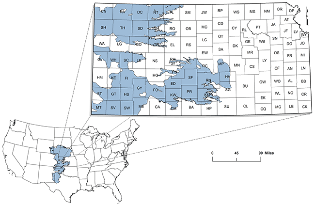
Aquifers are underground deposits of permeable rock or sediments (sands and gravels) from which water can be pumped in usable quantities. The High Plains aquifer is a regional aquifer system composed of several smaller units that are geologically similar and hydrologically connected--that is, water can move from one aquifer to the other. The High Plains aquifer lies beneath parts of eight states in the Great Plains, including about 30,800 square miles of western and central Kansas (fig. 1).
Aquifer characteristics are determined in large part by geology. The High Plains aquifer is composed mainly of silt, sand, gravel, and clay--rock debris that washed off the face of the Rocky Mountains and other more local sources over the past several million years. The aquifer varies greatly from place to place: thick in some places, thin in others; permeable (able to transmit water easily) in some places, less so in others. Where the deposits are thick and permeable, water is easily removed and the aquifer can support large volumes of pumping for long periods. In most areas, this water is of good quality.
The most important component of the High Plains aquifer is the Ogallala aquifer, generally the western half of the High Plains aquifer in Kansas. In some locations (such as Lake Scott State Park in Scott County), the Ogallala Formation, for which the aquifer is named, crops out at the surface, forming a naturally cemented rock layer called mortarbeds. In the subsurface, the Ogallala largely consists of sands and gravel that are interlayered with silt and clay beds that are mostly unconsolidated, or not naturally cemented together.
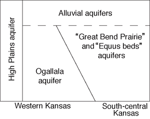
The south-central extension of the High Plains aquifer is composed of younger sediments that are similar to the Ogallala. These younger sediments, deposited during the Pleistocene Epoch, or Ice Ages, include the Equus Beds aquifer (in McPherson, Reno, Harvey, and Sedgwick counties) and the Great Bend Prairie aquifer (in Stafford, Edwards, Pratt, Kiowa, and other counties). Also lying above the Ogallala Formation are other Pleistocene deposits and other younger deposits in the valleys of modern streams. Where these stream deposits (known as alluvium) are connected to the Ogallala or Pleistocene aquifers, the alluvial aquifers are considered part of the High Plains aquifer (fig. 2).
Figure 2--Schematic (A) and map (B) showing aquifers that make up the High Plains aquifer.
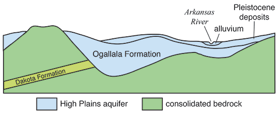
Beneath the High Plains aquifer is much older, consolidated bedrock, usually limestone, sandstone, or shale (fig. 3). In some places, this bedrock holds enough water to be called an aquifer, and it may be connected to the overlying aquifer. Layers of permeable sandstone in the Dakota Formation, for example, are connected to the High Plains aquifer in parts of southwestern and south-central Kansas. Some layers of the underlying bedrock contain saltwater; where these are directly connected to the High Plains aquifer, they pose a threat to water quality.
Figure 3--Generalized cross section showing the High Plains aquifer and underlying bedrock. The Ogallala Formation, Pleistocene deposits, and alluvium combine to form the High Plains aquifer.
Usable water in the High Plains aquifer is in the pore spaces between particles of sand and gravel. This water (called groundwater) accumulated slowly--in some of the deeper parts of the aquifer, over tens of thousands of years. In the subsurface, water in the aquifer generally moves slowly from west to east, usually at the rate of tens of feet per year.
Recharge is the natural movement of water into an aquifer, usually from precipitation. Natural recharge to the High Plains aquifer from precipitation is low, in part because much of the rain falls during the growing season, when plant roots intercept the soil moisture. In western Kansas, where precipitation is scant and the water table is relatively deep (a few hundred feet) in many places, recharge occurs infrequently and the long-term average is less than an inch per year. In central Kansas, where the aquifer is closer to the land surface, where soils are sandier, and precipitation amounts greater, recharge can be significant, as much as 4 to 6 inches per year.
Water volumes and use are measured in various ways. One measure is an acre-foot, or the amount of water necessary to cover an acre of ground (a parcel about the size of a football field) with a foot of water. An acre-foot equals 325,851 gallons of water. In 2005, about 19 million acre-feet of groundwater was removed from the High Plains aquifer eight-state region (McGuire, 2011). In Kansas in 2013, the High Plains aquifer yielded 3.13 million acre-feet, of which 2.47 million acre-feet came from the Ogallala aquifer. Estimated average annual natural recharge to the Ogallala in Kansas is 0.75 million acre-feet.
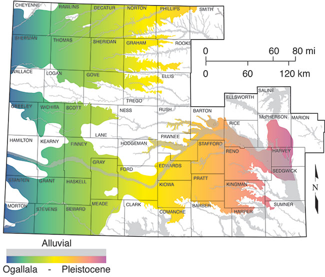
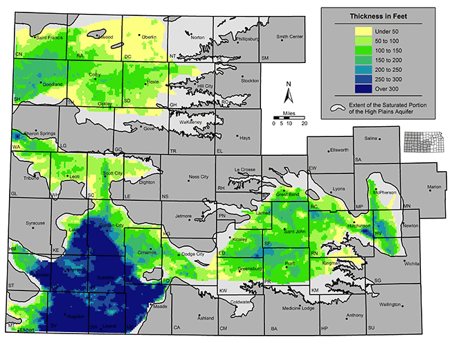
A key aquifer characteristic is its saturated thickness--the thickness of the sands, gravels, and other materials that are saturated with water. Saturated thickness is commonly measured in feet, but "feet of saturated thickness" is not the same as feet of actual water. Only 10-25% of the aquifer volume is pore space that can yield extractable water. Therefore, in an aquifer with 17% pore space, a 6-ft drop in the water table equates to about a foot of extractable water. In Kansas, the saturated thickness in the High Plains aquifer is generally greatest in the southwestern part of the state (see fig. 4). There, saturated thicknesses of 300 feet and greater were common before the onset of large-scale irrigation, a time that is often called "predevelopment."
Figure 4--Predevelopment saturated thickness for the High Plains aquifer in Kansas.
Aquifers can also be characterized by how much water can be removed by a well over short periods. Large volumes of water can be pumped rapidly (1,000 gallons or more per minute) from the High Plains aquifer in many locations. This contrasts with much of the rest of the state, where wells generally produce smaller amounts (less than 100 gallons per minute). By way of comparison, a good household well produces 5 to 10 gallons per minute, although many household wells produce less.
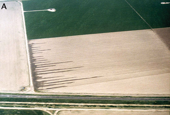
Large-scale irrigation began in western Kansas in the late 1800s, with the use of ditches to divert water from the Arkansas River. As technology improved, groundwater became the major irrigation source because surface water (lakes, rivers, and streams) is relatively scarce in western Kansas. With the advent of large-capacity pumps that were capable of drawing several hundred gallons of water per minute, people began to develop that groundwater. Using a technique called flood irrigation, water was pumped through long pipes or ditches along the edges of a field, then out onto rows of crops (fig. 5A).
Figure 5--Aerial photos of (A) flood and (B) center-pivot irrigation (photos courtesy of Tom Schmiedeler, Washburn University).
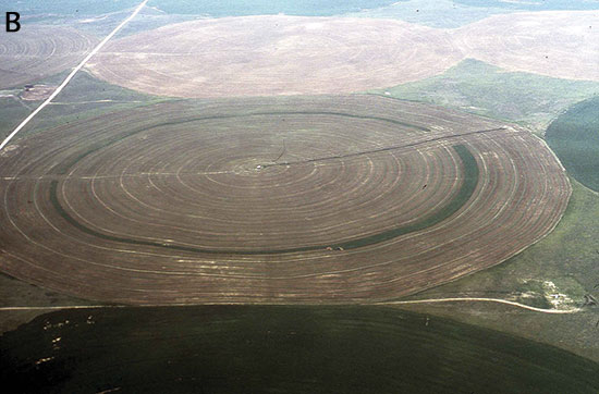
In the 1950s and 1960s, technological developments led to a dramatic increase in large-scale pumping. In particular, center-pivot irrigation systems--large sprinklers that roll across the land on wheels--allowed people to irrigate uneven terrain, thus opening up large new areas for irrigation (fig. 5B). These irrigation methods led to the cultivation of crops, such as corn, that could not previously be grown reliably in the area. That grain production led, in turn, to large feedlots and packing plants and a boom in the economy of much of western Kansas, all largely dependent on groundwater. Irrigated corn and wheat in southwest Kansas alone were estimated to contribute more than $900 million to the Kansas economy in 2013 (Roe, 2014, Kansas Department of Agriculture, personal communication).
For many years, people believed that the High Plains aquifer contained an inexhaustible amount of water. However, large-volume pumping (mostly for irrigation) eventually led to substantial declines in the water table, and people realized that the amount of water in the aquifer was finite and could be exhausted. Much of the Ogallala portion of the High Plains aquifer has declined since predevelopment, in some areas by more than 60% (fig. 6).
Figure 6--Percent change in saturated thickness for the High Plains aquifer in Kansas, predevelopment to 2012-2014.
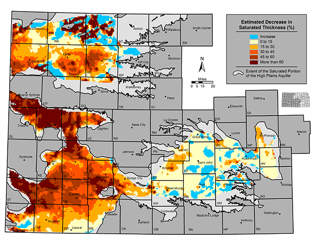
Nonetheless, in much of the aquifer, considerable amounts of water remain. For example, declines of 100 feet or more have occurred in parts of southwestern Kansas, but that represents less than half of the original saturated thickness, and 100 to 200 feet (or more) of saturated thickness may remain. In contrast, in parts of west-central Kansas--such as Greeley, Wichita, Scott, and northern Finney counties--the original saturated thickness was much less, often less than 100 feet. In these places, where early flood-irrigation systems were prevalent, less than 50 feet of saturated thickness remains.
Perhaps the most common and important question about the High Plains aquifer is how much longer can it support large-scale pumping? It's a simple question with a complicated answer. First, the aquifer will probably be able to support small, domestic wells far into the future. With proper planning, most cities and towns should be able to provide for their water needs. Second, the future of agricultural use of the aquifer depends on a variety of factors, including the price and type of irrigated crops, the price and availability of energy (the deeper the water table, the more energy it takes to pump water), climate, and how the water is managed. Third, the aquifer is not one consistent, homogeneous unit. In places, the aquifer consists of less than 50 feet of saturated thickness and receives little recharge. In other places, the aquifer is far thicker or receives considerably more recharge.
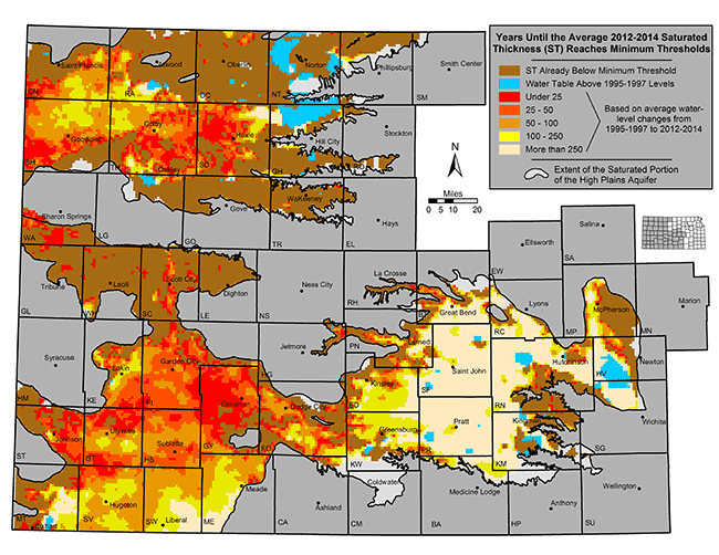
With those qualifications in mind, researchers at the Kansas Geological Survey have made simple projections about the aquifer, based on past trends in water-level declines. Obviously, the actual future use of water will be affected by many factors. Relatively little data are available for some parts of the aquifer, and projections are not practical in those areas. Assuming saturated thickness sufficient to support pumping of at least 400 gallons per minute throughout the growing season, researchers concluded that parts of the aquifer are effectively exhausted in Greeley, Wichita, and Scott counties (fig. 7). Other parts of the aquifer, in areas such as southwestern Thomas County, are projected to have a lifespan of less than 25 years. However, the biggest share of the aquifer in southwest Kansas would not be depleted for 50 to 200 years. It is important to remember that these projections are based solely on past water-level trends, and future changes could alter the actual depletion rate.
Figure 7--Estimated usable lifetime (average 1995-1997 to 2012-2014 trend) for the High Plains aquifer in Kansas.
Responsibility for managing water use in Kansas is spread over several agencies. The Division of Water Resources (DWR) of the Kansas Department of Agriculture (KDA) is responsible for administering water rights and thus is primarily responsible for regulation related to the quantity of water used. Water issues also are subject to local control and management. Five groundwater management districts (GMDs) have been created in Kansas to provide local management within the framework of the state's water laws. Together, they cover nearly all of the state underlain by the High Plains aquifer (fig. 8). GMDs, through staff and an elected board, develop and implement policies and rules and regulations to manage the quality and quantity of water, undertake educational activities, and work with state and federal water-related agencies to regulate and manage the High Plains aquifer.
Figure 8--Groundwater management district boundaries, Sheridan 6 LEMA, and index well site locations in Kansas.
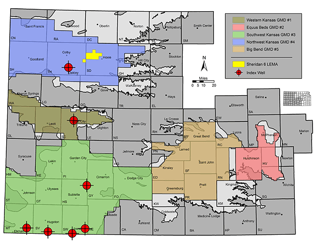
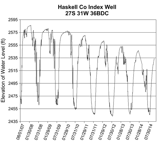
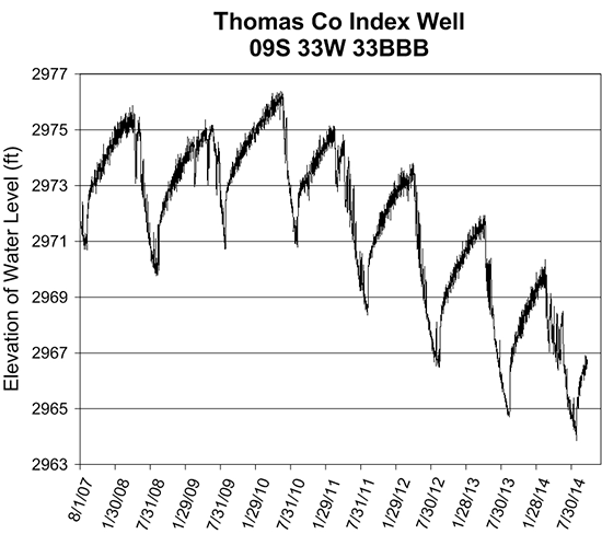
GMDs allow management plans to be tailored to their particular locations and implemented at regional to local levels. To assist in measuring and interpreting the hydrologic responses at this finer scale, the KGS's Index Well Program, a State Water Plan initiative, currently has seven continuous water-level recorders located in the three western Kansas GMDs. Hydrographs show that water-level conditions fluctuate greatly across a calendar year as the aquifer responds to pumping, changes in barometric pressure, and other factors. The water table at the Haskell County index well site fluctuates more than 120 ft during the growing season as it drops through a large and significantly less water-yielding clay layer that separates the more porous sections of the aquifer, an indication that estimated usable lifetime projections are overly optimistic in this location (fig. 9). In comparison, the Thomas County index well site shows remarkable consistency in its responses to pumping and is the only index well to have its minimum recorded water-level elevation not decline every year. This suggests that a significant amount of unaccounted for flow comes into the aquifer at this location and that relatively modest reductions in pumping might stabilize water levels in the short term.
Figure 9--Hydrographs showing water-level fluctuations in index wells in Haskell and Thomas counties.
By Kansas law, water is a public resource that is dedicated to the use of the people of the state. Individuals, companies, municipalities, and other entities can obtain permission to use water for beneficial purposes by obtaining a water right, either new or existing. In general, all beneficial uses of water, except most domestic use, require a water right. Kansas water law is based on the doctrine of prior appropriation. That is, when there is insufficient water to meet all water rights, the date of the water right determines who has the right to use the water. This doctrine is commonly expressed as "First in time, first in right."
In south-central Kansas, the Equus Beds and Big Bend GMDs 2 and 5 manage the aquifer based on safe yield policies, where the amount of water appropriated under water rights is equal to or less than the amount of recharge, depending on the impact on water quality and minimum streamflows. Adoption of a similar policy across the Ogallala portion of the High Plains aquifer would require substantial decreases in the amount of water currently used, which would affect cropping patterns and potentially economic activities.
In western Kansas, the emphasis has been on responses tailored to local conditions. In 2012, legislation was passed to allow the creation of Local Enhanced Management Areas (LEMAs). LEMA management plans are locally generated, have set operational time lines, and are supported by regulatory oversight. The KDA DWR reviews and either approves or rejects the plan but cannot modify it without local approval. To date, only one LEMA has been established--Sheridan 6 in northwestern Kansas. Here, local water right holders voluntarily agreed to reduce their water usage by 20% for the next five years with the hope of slowing groundwater declines and extending the life of the aquifer. Initial results indicate that reductions are slowing the rate of decline.
The authors acknowledge the assistance of Dave Young, formerly of the Kansas Geological Survey, and Bob Sawin, Kansas Geological Survey, in the preparation of this circular.
Kansas Geological Survey, http://www.kgs.ku.edu/
Kansas Department of Agriculture, Division of Water Resources, http://agriculture.ks.gov/divisions-programs/dwr
Kansas Water Office, http://kwo.ks.gov/
U.S. Geological Survey's Water Resources Division Office, Lawrence, http://ks.water.usgs.gov/
Ashworth, W., 2006, Ogallala blue--Water and life on the High Plains: W. W. Norton and Co., 330 p.
Buchanan, R., and Buddemeier, R., compilers, 1993, Kansas ground water: Kansas Geological Survey, Educational Series 10, 44 p. [available online]
Gilson, P., Aistrup, J., Heinrichs, J., and Zollinger, B., 2001, The value of Ogallala aquifer water in southwest Kansas: Docking Institute of Public Affairs, Fort Hays State University, 82 p.
Kahl, D. W., and Powell, G. M., 2001, Agency authority and responsibilities for water in Kansas: Kansas State University, Agricultural Experiment Station and Cooperative Extension Service, MF-2503, 4 p.
Kromm, D., and White, S., 1992, Groundwater exploitation in the High Plains: Lawrence, Kansas, University Press of Kansas, 240 p.
McGuire, V. L., 2011, Water-level changes in the High Plains aquifer, predevelopment to 2009, 2007-08, and 2008-09, and Change in Water in Storage, Predevelopment to 2009: U.S. Geological Survey, Scientific Investigation Report 2011-5089, 13 p. [available online]
Opie, J., 1993, Ogallala--Water for a dry land: Lincoln, Nebraska, University of Nebraska Press, 412 p.
![]()
![]()
![]()
Kansas Geological Survey, Public Outreach
Comments to webadmin@kgs.ku.edu
Revised Jan. 2015, placed online Feb. 19, 2015
http://www.kgs.ku.edu/Publications/PIC/index.html