Kansas Geological Survey, Public Information Circular (PIC) 16
Prev. Page--What are Kimberlites? || Next Page--Economic Potential
![]()
![]()
![]()
![]()
Kansas Geological Survey, Public Information Circular (PIC) 16
Prev. Page--What are Kimberlites? ||
Next Page--Economic Potential
Diamonds were recovered in India as early as 300 B.C. and have been found on all continents since that time. In 1866, children in the Cape Province of South Africa found a white pebble on the banks of the Orange River that turned out to be a 21.25-carat diamond. By 1869, a full-fledged diamond rush was underway. By tracing diamonds upstream, prospectors noted that soils where diamonds occurred also contained garnets, ilmenites, and clinopyroxenes, minerals rarely found in soils. In 1870 a farmer spotted the same minerals on his own farm and, after only a week of searching, recovered a 50-carat diamond. This was the first site in the world where diamonds were recovered from the clay-rich, soft, weathered kimberlite (known as yellow ground) that had carried the diamonds to the surface. With depth the weathered material turns into harder, bluish-gray rock called blue ground. Its characteristic color is used worldwide in prospecting for kimberlites.
Most of the world's kimberlites occur in South Africa, where over 3,000 kimberlite pipes have been found. Over 200 are known in North America, of which about 40 occur near the Colorado-Wyoming state line. Important new discoveries have been made in northern Canada in the last decade. Of the thousands of known kimberlites, fewer than about 1,000 contain diamonds, and of those, only about 50 to 60 have contained enough diamonds to be mined economically.
Kimberlites have been intruded into the earth's crust at various times. The intrusions are clustered in about ten time periods ranging from 1,600 million years to about 55 million years ago. Kansas kimberlites were intruded in the Cretaceous Period, about 90 million years ago.
Kansas kimberlites are located near Tuttle Creek Lake in Riley and Marshall counties (fig. 1). It is difficult to know what the countryside in the area looked like 90 million years ago, when the kimberlites exploded to the surface. However, by studying sedimentary rocks of approximately the same age deposited farther to the west, geologists conclude that the area was probably rather flat, very dry, and not too far from a seaway. In the 90 million years since the kimberlites were emplaced, much of the material has been eroded away. The kimberlites studied today represent deeper levels of the original kimberlite pipes.
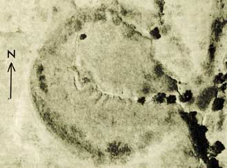
The first kimberlites were discovered in Kansas in the late nineteenth century; at first, these kimberlites weren't recognized as igneous rocks (Brookins, 1970a). Several more kimberlites were identified in the 1930's and 1950's (Tolman and Landes, 1939; Byrne et al., 1956). Another kimberlite was discovered in 1969 by drilling at the Winkler crater site in northern Riley County (fig. 4). Previously, people had speculated that the crater was formed from a meteorite impact (Barringer, 1964; Freeberg, 1966).
Figure 4--Aerial photo of the Winkler crater (Brookins, 1970, GSA Bulletin 81, fig.1).
Because kimberlites contain more magnetic minerals than the surrounding rocks, magnetic surveys are commonly used to find kimberlites that are not exposed at the surface. Aeromagnetic surveys were carried out in parts of Riley and Marshall counties in the early to middle 1980's to explore for new kimberlites. Other means of searching for kimberlites involve panning creeks and rivers to search for indicator minerals, such as garnet, that typically occur in kimberlites. Both methods were used in Kansas and, as a result, four more kimberlites were identified.
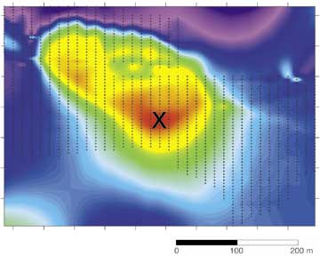
Recently, the Kansas Geological Survey used aeromagnetic survey data (donated by Cominco American, Inc.) to delineate other potential kimberlites. Detailed magnetic surveys (fig. 5) on the ground were then conducted at locations derived from the aerial surveys, and drilling in the fall of 1999 confirmed the presence of three additional kimberlites. These are the Tuttle, Baldwin Creek, and Antioch kimberlites. The Tuttle kimberlite is covered by only a few feet of soil, the Baldwin Creek by 25 feet (7.5 m), and the Antioch by 21 feet (6.4 m). Each of the three kimberlites was cored to a depth of 300 feet (91 m) for further studies.
Figure 5--Image showing the results of magnetic surveys conducted at the Baldwin Creek kimberlite site in Riley County, Kansas. The red area in the center indicates the strongest magnetic readings. An "x" marks the drill site. The yellow area roughly outlines the boundaires of the kimberlite.
Prev. Page--What are Kimberlites? || Next. Page--Economic Potential
Kansas Geological Survey, Public Outreach
Web version July 2000
http://www.kgs.ku.edu/Publications/pic16/pic16_3.html