![]()
![]()
![]()
Kansas Geological Survey, Public Information Circular (PIC) 28
A complete text of this file is available as a pdf document.
Shane A. Lyle, Kansas Geological Survey
Revised by Anthony L. Layzell, Kansas Geological Survey
Melting glaciers in Earth's polar and alpine regions are beacons of climate change. To better understand what is happening today, it is helpful to consider past glaciation and climate-change examples. Glaciers seemingly couldn't be further removed from the hot summers and windswept plains of Kansas. However, in the not-so-distant geologic past, glaciers repeatedly advanced across the Midwest and at least twice reached northeast Kansas. As the ice progressed across the continent, the landscape, climate, plants, and animals all changed.
The purpose of this public information circular is to show how Kansas was literally on the forefront of climate change when a continental ice sheet last extended into the northeast corner of the state about 700,000 years ago. The geologic sciences are uniquely capable of describing these events, in that geologists nearly always look back in time to understand our current climate and environment.
This publication provides insight into how the Midwest was affected by repeated continent-sized glacial advances during the Pleistocene Epoch. It explains glaciation in Kansas and the ecological and climate response since the last ice sheet retreat. The Pleistocene provides an important analog, or past example, to better understand some of the concepts associated with climate change.
The Pleistocene Epoch lasted from about 2.6 million to 11,700 years ago. Although commonly referred to as the Ice Age, the Pleistocene encompassed many glacial and interglacial events and warm and cool climates. It was also a period of volcanic activity in North America and along the North and South American Pacific coasts. In Kansas, at least three large ash falls from volcanoes in California, New Mexico, or the Yellowstone National Park area were deposited throughout the state.
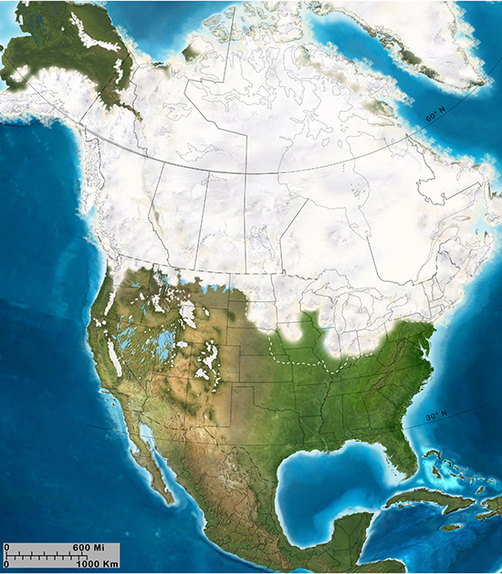
During the Pleistocene, continent-sized ice sheets formed in different parts of the world: North America, Greenland, Eurasia, Tibet, the Himalayas, and Antarctica. Ice sheets in the polar regions and Greenland were fairly stable, but other areas, including North America, saw repeated expansion and contraction in response to fluctuating climates (fig. 1). These successive glacial advances and retreats are known as glacial stages and interglacial stages, respectively.
Figure 1. Extent of glaciation in North America. Solid white areas represent Late Wisconsinan ice sheets and glaciers. Dotted white line indicates maximum extent of older Quaternary glaciations. Copyright 2013 Colorado Plateau Geosystems Inc.
In North America, geologists recognize four stages. They are the Pre-Illinoian (2.6 million-191,000 years ago), Illinoian (191,000-130,000 years ago), Sangamonian (130,000-71,000 years ago), and Wisconsinan (71,000-11,700 years ago).
During each stage, many smaller, regional lobes of ice locally advanced and retreated (fig. 2). The Pre-Illinoian Stage included many glacial and interglacial stages, with 11 distinct glacial stages currently recognized. The Sangamonian was a warm interglacial stage of ice retreat.
Figure 2. Maximum extent of pre-Illinoian and late Pleistocene ice sheets (after "Glacial stratigraphy and paleomagnetism of late Cenozoic deposits of the north-central United States," by M. Roy, P. U. Clark, R. W. Barendregt, J. R. Glasmann, and R. J. Enkin, 2004, Geological Society of America Bulletin, v. 116, no. 1-2, https://doi.org/10.1130/B25325.1).
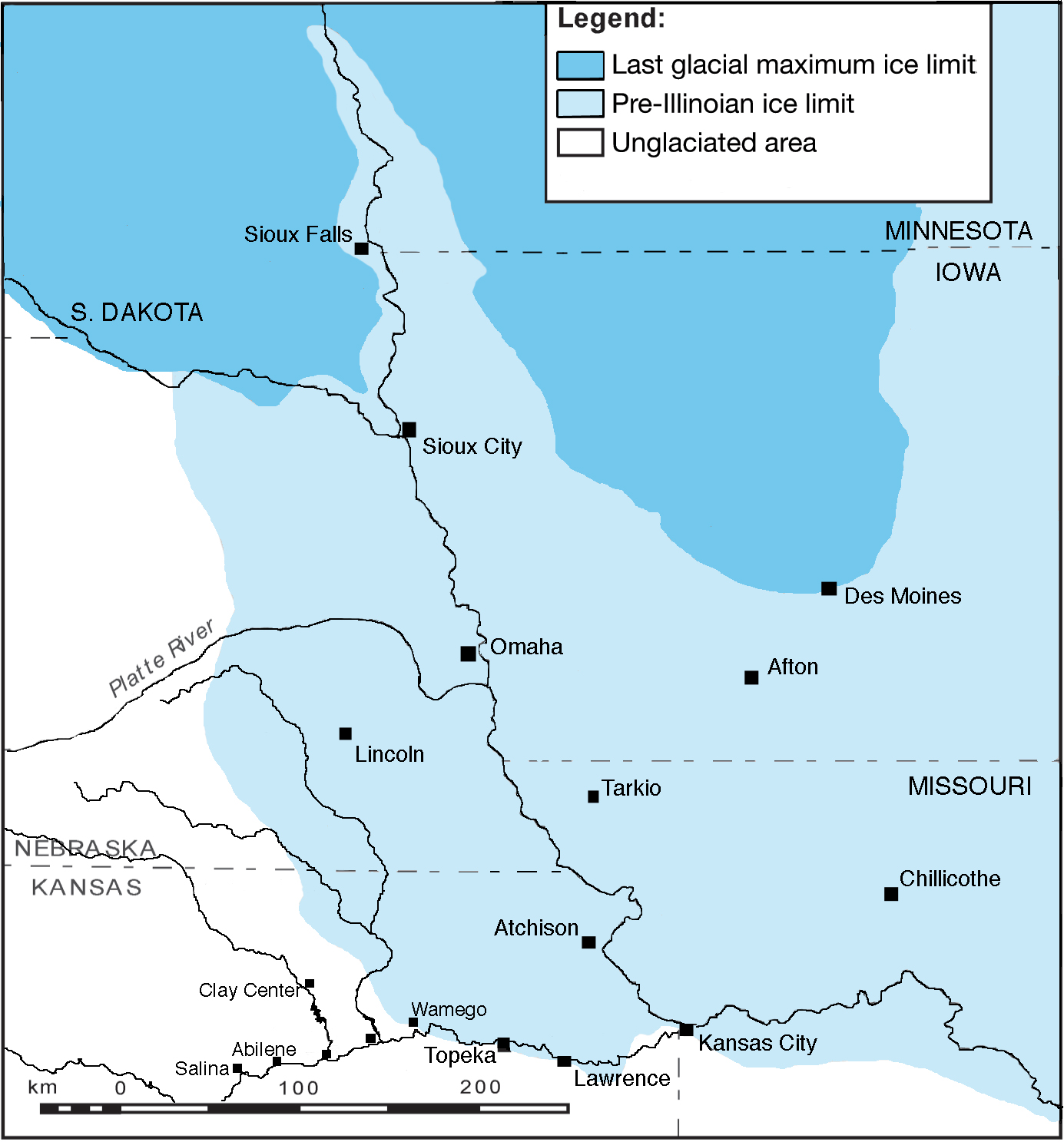
At its peak, Pre-Illinoian ice covered more than one-third of North America and extended into northeastern Kansas. In Kansas, at least two separate glacial advances took place, first from Minnesota and later from the Dakota regions. Ice lobes dammed the ancestral Kansas River in several places and crept over the locations of present-day Topeka, Lawrence, and downtown Kansas City (fig. 2).
At its maximum, Illinoian ice covered most of Illinois and did not enter Kansas. Wisconsinan ice reached as far south as Nebraska and Iowa, and glacial deposits from this period provide important clues to the Pleistocene ecology and climate.
The Wisconsinan Stage at the end of the Pleistocene Epoch was followed by the Holocene Epoch (11,700 years ago to the present). Although the Holocene has been a warm period without active glaciation, fluctuations in the climate still have occurred. A time of significant climatic variability from about 900 to 1300 AD known as the Medieval Warm Period (MWP) was first identified in northern Europe and later also documented elsewhere, including parts of the western United States. A shift to droughts of shorter duration around 1500 coincided with the onset of cooler climatic conditions during a period known as the Little Ice Age, which contributed to widespread social unrest in Europe. In France, crop failure due to climatic changes helped spark the French Revolution that led to the beheading of Marie Antoinette. Many geologists believe we haven't left the last ice age and simply consider the Holocene as a short warm period before the next glacial onset.
The initial Kansas ice front was probably only tens of feet thick and slid irregularly forward under pressure from thicker ice to the north. Buried wood in Atchison and Doniphan counties indicates that the ice likely overrode a spruce forest there. If a time-lapse picture could have recorded the Pleistocene Epoch, it would have shown a lurching, amoeba-like ice movement along with ecological waves of tundra, forests, and grasslands progressing across the Great Plains as glaciers advanced and retreated.
Advancing ice reshaped the land, forcing new stream channels and burying others. Before glaciation, the ancestral Missouri River was a lesser tributary to a larger ancestral Kansas River. Then advancing ice pushed the drainage from a now-buried river valley that flowed past Tarkio and Chillicothe, Missouri, into the present-day Missouri River (fig. 2). The Big and Little Blue rivers in Marshall and Pottawatomie counties probably developed as ice-margin streams or spillways to a proglacial lake, a lake formed just beyond the frontal margin of a glacier, near Atchison. Advancing ice also buried ancestral rivers that once flowed east through Marshall, Nemaha, Jackson, Brown, Atchison, and Doniphan counties in northeastern Kansas. Some of these valleys were more than 3 miles (4.8 km) wide, 400 feet (122 m) deep, and 75 miles (121 km) long. These buried valleys are now important groundwater sources for agriculture and industry in an area that otherwise does not have much groundwater.
When the ice flow reached a depression such as the Kansas River, it spilled over the side, slowly filled the valley, then flowed over the opposite side. The ice was perhaps 300 feet (91 m) thick north of the river near Wamego and 500 feet (153 m) thick over the Kansas River valley. An ice lobe covering what is now the Kansas City area was probably hundreds of feet thick (fig. 2).
Glacial ice transports all sizes of sediment and rocks, often for hundreds of miles. Deposits of debris, ranging in size from boulders to clay particles, are collectively called glacial drift. Drift deposits are found in Washington, Marshall, Nemaha, Brown, Doniphan, Riley, Pottawatomie, Jackson, Atchison, Jefferson, Leavenworth, Wyandotte, Johnson, Douglas, Shawnee, and Wabaunsee counties.
Most glacial landforms, such as moraines (mounds or ridges of drift deposited by direct action of glacier ice), are largely absent in Kansas due to long periods of erosion since pre-Illinoian time. Some glacial features and deposits, however, are still visible on the surface. Directional grooves carved into limestone bedrock have been mapped in Nemaha, Brown, Doniphan, Atchison, Jefferson, Leavenworth, Wyandotte, Johnson, and Shawnee counties. A thick blanket of mixed soil and rocks, called till, covers large portions of northeastern Kansas. "Till" is Scottish for a drift deposit that formed underneath glacial ice and was not reworked by meltwater (water from melting snow or ice that flows out in streams and carries rocks and sediment away from a glacier).
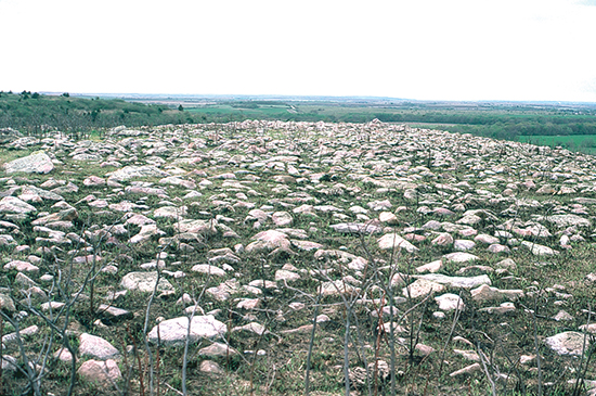
Glacial ice carried and dropped previously weathered rocks from hundreds of miles away into Kansas. Collectively called erratics, these rock fragments range from the size of pebbles to house-sized blocks. The most common is Sioux Quartzite, a pink metamorphosed sandstone more than a billion years old. Sioux Quartzite boulders in Kansas came from southern Minnesota, South Dakota, and northwestern Iowa. Sometimes these rocks occur in such density that geologists describe the resulting block field or masses of rock rubble on summits as a felsenmeer, German for "sea of rocks" (fig. 3).
Figure 3. . Sea of Sioux Quartzite erratics on ridge crest 5 miles (8 km) south of Wamego..
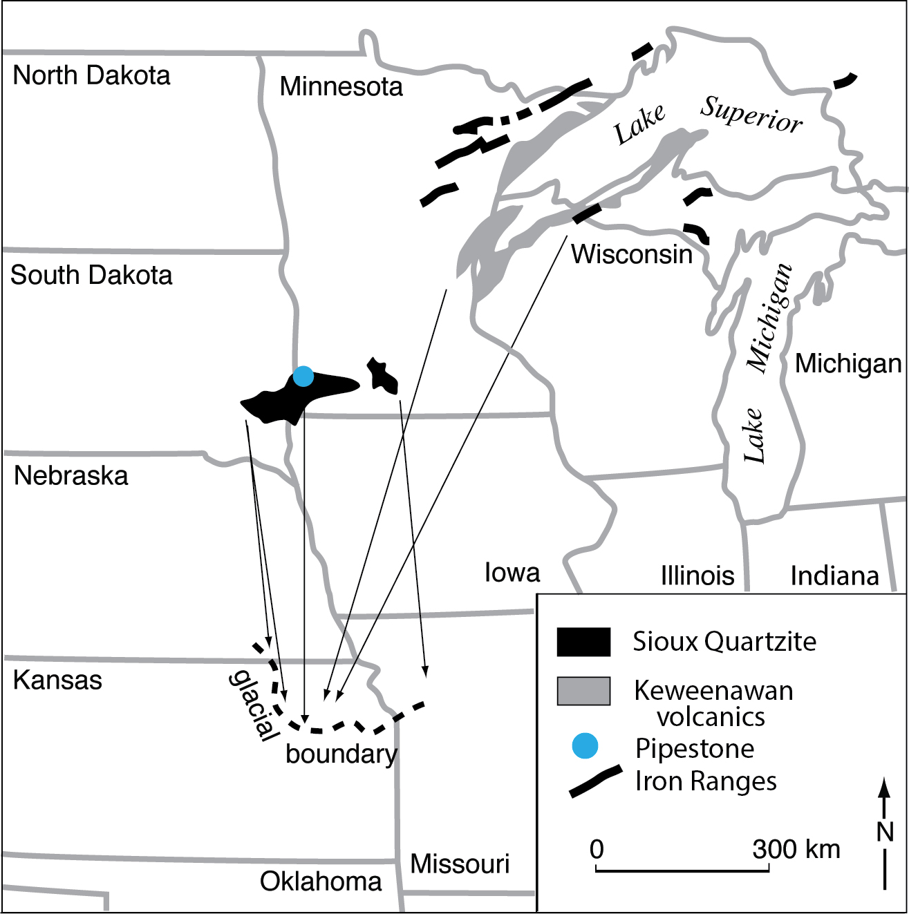
More exotic erratics, such as granitic rocks, Lake Superior agate, Duluth-area iron ore, Keweenawan volcanics, and native copper, are occasionally found in Kansas. Isolated occurrences of catlinite, which sometimes occurs with Sioux Quartzite, are present in the Tower Hill area north of McFarland. Also called pipestone because early Native Americans valued it for carving tobacco pipes, catlinite is purplish-red, ultra-fine grained, and soft. Erratic assemblages help geologists better understand the origin and direction of glacial movement (fig. 4). In particular, catlinite, found in a small area at Pipestone National Monument in southern Minnesota, was carried almost 345 miles (552 km) into Kansas.
Figure 4. . Sources of identifiable glacial erratics found in northeastern Kansas. Fragments of Sioux Quartzite are common throughout the terminal zone and eastward into Missouri. Specimens of ore from the Iron Ranges are scarce. Distribution of Lake Superior agates from the Keweenawan volcanics is highly localized, seemingly restricted to an area in and near Topeka. Credit: Wakefield Dort, Jr..
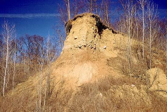
Because glacial retreat exposed lake beds and meltwater left river valleys covered with silt-sized sediment, large tracts of land were susceptible to wind erosion. Strong prevailing winds picked up lightweight debris and whipped up immense sand and sediment storms that far exceeded the storms of the Dust Bowl era. These storms blanketed the Midwest with sand dunes and thick layers of fine-grained silt called loess, which is still found at or near the surface throughout much of Kansas (fig. 5).
Figure 5. . Because of its grain angularity and cementation, loess remains standing vertically for years in excavations and roadcuts..
Before disappearing from northeast Kansas, pre-Illinoian ice thinned, leaving hilltops exposed like islands in a sea of ice. In valleys, stagnant and isolated ice persisted for centuries before finally melting away. Later Illinoian and Wisconsinan ice sheets that spread southward across the upper Midwest did not reach Kansas.
Climate changes associated with the Pleistocene glacial cycles altered the Great Plains landscape. Ecological succession in Kansas included tundra (permafrost found in alpine and arctic areas), taiga (spruce, fir, and pine now found farther north), temperate climate deciduous hardwood forests like those in eastern Kansas today, and grasslands found in temperate to semi-arid climates similar to those in central and western Kansas today.
At the onset of the Pleistocene, Kansas was much like it is today. As ice advanced, Kansas's plant and animal communities moved along with the glacial front. Northern plants adapted and migrated south, and conifer forests, typically only found hundreds of miles to the north, spread into Kansas. By the height of the last glaciation, spruce, balsam poplar, and aspen trees had advanced to the Midwest.
During glacial retreats when the climate warmed, animal species not adapted to the cold, such as armadillos, sloths, and giant tortoises, migrated north. Excavations of the remains of seven mammoths at Lovewell Reservoir in Jewell County give a glimpse of life in Kansas near the last glacial maximum, when ice sheets were at their greatest extent, about 20,000 years ago. An ancestral river here probably supported lush vegetation during a relatively dry period and attracted a diversity of animals. Archaeological research documents mammoths, bison, camels, dire wolves, horses, llamas, and sloths, as well as many smaller mammal, reptile, and bird species still found in Kansas. Spiral fractures in mammoth bones and bone piles that appear to be stacked suggest that some of these mammoths may have either been killed or scavenged by humans around 20,000 years ago, though human occupation in Kansas before 13,000 years ago has not been verified.
Other Kansas Pleistocene mammals, now extinct, include giant beavers, stag-moose, fronted musk oxen, peccaries, rhinos, and saber-toothed and dirk-toothed cats. In addition to mammoths, mastodons lived in Pleistocene forests of Kansas, eating leaves and bark in spruce swamps or pine parks. Mammoths, in contrast, were larger and specialized in eating grass and preferred comparatively open ground, especially tundra.
Acknowledgments--Thanks to Rex Buchanan, Robert Sawin, Rolfe Mandel, Catherine Evans, Marla Adkins-Heljeson, and Julie Tollefson for reading and commenting on this circular.
Kansas Geology-An Introduction to Landscapes, Rocks, Minerals, and Fossils
R. Buchanan, ed., University Press of Kansas, Lawrence, 2nd edition, 2010, 240 p.
Kansas Geological Survey and Missouri Geological Survey and Water Resources: Pleistocene Stratigraphy of Missouri River Valley along the Kansas-Missouri Border Guidebook: 20th Annual Meeting of the Midwest Friends of the Pleistocene, Kansas Geological Survey, Special Distribution Publication 53, 1971, 32 p.
Guidebook of the 18th Biennial Meeting of the American Quaternary Association
R. Mandel (ed.), Kansas Geological Survey, Technical Series 21, 2006, 146 p.
Hydrogeology and Geochemistry of Glacial Deposits in Northeastern Kansas
J. E. Denne, R. E. Miller, L. R. Hathaway, H. G. O'Connor, and W. C. Johnson, Kansas Geological Survey, Bulletin 229, 1998, 127 p.
Quaternary Stratigraphy and Stratigraphic Nomenclature Revisions in Kansas
Current Research in Earth Sciences
A. L. Layzell, R. S. Sawin, E. K. Franseen, G. A. Ludvigson, W. L. Watney, and R. R. West, Kansas Geological Survey, Bulletin 263, 2017, 8 p.
![]()
![]()
![]()
Kansas Geological Survey, Public Outreach
Comments to webadmin@kgs.ku.edu
Revised web version December 2020
http://www.kgs.ku.edu/Publications/PIC/pic28.html