KGS Home Geology Home Reports

Kansas Geological Survey, Open-file Report 2011-9


Field Geology Maps--Morris County, Kansas

Preliminary Field Geology Maps for Burdick, Diamond Springs, and Lost Springs 1:24,000-Scale Quadrangles

by
Robert S. Sawin and Ronald R. West


KGS Open File Report 2011-9
Dec. 2011


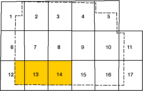
Morris County, Kansas--Index to 1:24,000-Scale Maps

Quadrangles maps are in east-central Morris County.

  1. Woodbine--1964
  2. Skiddy--1964
  3. White City--1971
  4. Dwight--1971
  5. Alta Vista--1971
  6. Herington--1972
  7. Delavan--1972
  8. Wilsey--1972
  9. Council Grove Lake--1971
  10. Council Grove--1971 (83 PR)
  11. Bushong--1971
  12. Lost Springs--1972
  13. Burdick--1972
  14. Diamond Springs--1972
  15. Wilsey SE--1972
  16. Lake Kahola--1972
  17. Americus--1972

PR = Photorevised

Copies of the field maps are open-filed at the Kansas Geological Survey, Lawrence, Kansas.

The complete report is available as an Adobe Acrobat PDF file.

Report, control points, and photos (8.2 MB)

Preliminary map (12.9 MB)

To read this file, you will need the Acrobat PDF Reader, available free from Adobe.


Kansas Geological Survey, Geology
Updated July 11, 2012
Comments to webadmin@kgs.ku.edu
The URL for this page is http://www.kgs.ku.edu/Publications/OFR/2011/OFR11_9/index.html