Kansas Geological Survey, Open-file Report 2009-21
by
Kyle E. Gorynski and Rolfe D. Mandel
KGS Open File Report 2009-21
1--Introduction
2--Previous Research
3--Description of Study Area
3.1--Physiography and Geology
3.2--Vegetation
3.3--Climate
4--Research Methods
4.1--Field Methods
4.2--Laboratory Methods
5--Results
5.1--Stratigraphy
5.2--Sedimentology
5.3--Carbon Isotopes
6--Discussion and Conclusion
Figure 1--Picture overlooking the Willems fan
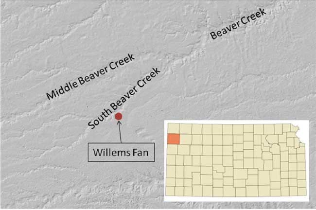
Figure 2--Map showing the location of the Willems fan
Figure 3--Picture showing stratigraphy in the Willems fan
Figure 4--Graph of grain-size distribution in the Willems fan
Figure 5-Depth function graph of grain-size, organic carbon and δ13C.
Table 1--Radiocarbon ages on soils in the Willems fan
Table 2--Soil stratigraphic description of the Willems fan
Table 3--Grain size distribution in the Willems fan
This study links the development of a fine-grained alluvial fan to late-Quaternary bioclimatic change on the High Plains of northwestern Kansas. The investigation of the Willems fan in Sherman County included sedimentological and stable carbon isotope analyses, and the numerical age of the fan was determined by radiocarbon dating soil organic matter from buried paleosols. Aggradation of the fan was underway by ca. 10,750 14C yr B.P. and continued through the middle Holocene. However, sedimentation on the fan was initially slow and accompanied by cumulic soil development. The δ13C data suggest that the initial phase of fan development (ca. 10,700-6550 14C yr B.P.) was accompanied by a general warming trend, though excursions in the δ13C values indicate that periods of soil development represented by paleosols coincided with slight cooling. An episode of sedimentation soon after ca. 6550 14C yr B.P. was rapid and uninterrupted by pedogenesis until the modern soil formed on the surface of the fan, probably around 3000 14C yr B.P. The most rapid period of sedimentation coincides with mid-Holocene warming reflected in the δ13C values of soil carbon and probably is related to the Altithermal warm/dry climatic episode. It is likely that aridification destabilized the uplands, resulting in erosion and the delivery of large volumes of sediment to alluvial fans. Hence, there is a strong relationship between rates of sedimentation on the Willems fan and regional bioclimatic change.
We would like to thank Laura Murphy, Dr. Greg Cane, and Dr. Caroline Davies for their assistance and guidance in lab research, and Evan Bargnesi and Rex Buchanan for editing the manuscript. The KU Odyssey Archaeological Research Fund supported this study.
Alluvial fans are important links between erosion on the uplands and sedimentation on valley floors. While many studies have focused on late-Quaternary alluvial terraces in the Great Plains, few have examined alluvial fans in the region (e.g., Faulkner, 2002; May, 1990; Mandel, 1990, 1992, 2006a, 2008; Mandel and Hofman, 2006). In contrast to alluvial terraces, alluvial fans record sedimentation directly from the uplands (Faulkner, 2002). Furthermore, the record of upland stability and instability is often preserved in fans. Soils within fans are products of stability, while subsequent burial of soils indicates instability. Cycles of erosion, sedimentation, and landscape stability recorded in alluvial fans may be linked to regional climatic and vegetative changes.
The Central Plains of North America experienced several significant climatic changes during the past 13,000 years. During the Younger Dryas Chronozone (11,000-10,000 14C yr. B.P.), the climate of North America was relatively cool and dry (Alley et al., 1993). However, by ca. 10,000 14C yr. B.P., the climate was becoming warmer. The early through mid-Holocene (10,000-4500 14C yr. B.P.) was characterized by general warming and drying, a climatic episode known as the Altithermal (Mandel, 2006b). Although there was a general shift to cooler and wetter conditions after ca. 4500 14C yr. B.P., the Central Plains experienced protracted droughts during the late Holocene (Cook et al., 2007), such as the Medieval warm period from about 1000-700 14C yr. B.P.
In the High Plains the boundaries between the short and mixed-grass prairie fluctuated throughout the Holocene in response to climatic variability. During warm, dry periods, the short-grass prairie expanded eastward. Aridity reduced vegetative cover, which in turn increased erosion on uplands. As erosion increased it is likely that sedimentation rates increased on footslopes along the margins of valley floors. Hence, the landscape response to aridification may be preserved in alluvial fans.
This study describes the evolution of a fine-grained alluvial fan in western Kansas. The objective of the study was to determine whether the formation of the fan is related to changes in climate and vegetation during the Holocene. Radiocarbon dating and stable carbon isotope analysis are used to determine the numerical age of the fan and to reconstruct vegetation, respectively. The results of this study shed light on late-Quaternary landscape evolution and its relation to bioclimatic change on the High Plains.
Few studies have focused on the evolution of late-Quaternary alluvial fans in the Great Plains, and even fewer have examined fans on the High Plains of western Kansas. This section reviews previous research on late-Quaternary alluvial fans and the relationship between fan sedimentation and bioclimatic change in the Great Plains.
Faulkner (2002) focused on Holocene sedimentation on alluvial fans in the central Great Plains of southwest Nebraska. This research describes the sedimentation history of four alluvial fans south of the Platte River valley. Five periods of sedimentation were recorded: ca. 9000, 5800, 4000, 3000, and 1000 14C yr. B.P. The sedimentation records within these fans exhibit periodic shifts from lower to higher sedimentation rates throughout the Holocene. Slow sedimentation rates are marked by buried soils, and pedogenically unmodified sediment between buried soils are products of rapid sedimentation (Faulkner, 2002). Faulkner (2002) proposes five episodes of increased sediment yield based on the assumption that landscape instability was directly related to sedimentation on the alluvial fans. Except for the sedimentation intervals at ca. 5800 and 4000 14C yr. B.P., these periods of increased sediment yield were related to shifts toward a drier climate (Faulkner, 2002). Regional bioclimatic data in the form of pollen records, plant macrofossils, phytoliths, and δ13C values of buried organic matter suggested a shift to prairie grasses and the disappearance of upland trees by 9000-8500 14C yr. B.P. (Faulkner, 2002; Baker et al., 2000). Other bioclimatic data suggest similar increases in aridity around 3000 and 1000 14C yr. B.P. separated by wetter conditions (Hall and Lintz, 1984; Baker et al., 2000).
A study by Mandel and Hoffman (2006) focused on the Simshauser alluvial fan in southwestern Kansas. The Simshauser fan formed on the valley floor of Mattox Draw during the early Holocene and is important to this study because of its geographic, sedimentological, and stratigraphic similarities with the Willems alluvial fan. Both fans consist of loess-derived alluvium and have multiple buried soils with similar age relationships.
The Simshauser fan contains three buried soils, two of which are developed at the top of upward-fining sequences (Mandel and Hofman, 2006). Bulk soil carbon from the upper 10 cm of the Akb3 and Bk1b2 horizons yielded radiocarbon ages of 10,170±70 yr. B.P and 9419±70 yr. B.P., respectively (Mandel and Hofman, 2006). Alluvial fan sedimentation began sometime before 10,170±70 14C yr. B.P., followed by a period of stability marked by a buried soil. A major episode of sedimentation followed, occurring between ca. 10,170 14C yr. B.P. and 9400 14C yr. B.P. Another period of stability, marked by a buried soil, occurred at ca. 9400 14C yr. B.P. Fan sedimentation ended with fan-head entrenchment sometime after ca. 9400 14C yr. B.P., although it most likely occurred much later since two other soils formed after ca. 9400 14C yr. B.P.
Mandel (1992) examined a large, low-angle alluvial fan the Smoky Hill River valley of east-central Kansas. The Eagle's Roost fan contained four buried soils. Soil organic matter from buried paleosols yielded radiocarbon ages of ca. 5750±70 and 5110±70 yr. B.P. Based on the temporal data, fan sedimentation was occurring during the mid-Holocene and fan-head entrenchment occurred sometime after 5100 14C yr. B.P (Mandel, 1992).
Mandel (1990) also examined an alluvial/colluvial fan on the valley floor of the Big Hill Creek in the southeastern corner of Kansas. Radiocarbon dates on charcoal from archaeological features within the fan suggest that accumulation of sediment took place between ca. 8800 and 2500 B.P., and the fan was relatively stable by 2000 B.P. (Mandel, 1990). The Stigenwalt and Eagle's Roost fans match regional patterns of landscape evolution. Specifically, upland erosion and fan development occurred in central and eastern Kansas during the early through mid-Holocene (9000-4000 14C yr. B.P.) (Mandel, 2006a).
There is evidence for the development of alluvial fans on the High Plains during the late Wisconsin, extending into the early-Holocene (12,000-9000 B.P.). For example, at the Adams Ranch Fan in the Cimarron River valley near Ashland, Kansas, there is evidence for three episodes of soil development associated with slow aggradation between ca. 13,000 and 9000 14C yr. B.P (Mandel, 2006a). The evolution of these fans was likely the result of sudden warming and a decrease in vegetative cover near the end of the Pleistocene, which destabilized the uplands and produced large sediment yields (Mandel, 2006a). However, sedimentation rates were slow during the Pleistocene-Holocene transition, allowing cumulic soils to develop in fan deposits on the High Plains (Mandel, 2008).
Cumulatively, previous studies have shown that alluvial fan development was initiated during the early Holocene in eastern Kansas, but was underway as early as ca, 13,000 14C yr. B.P in southwestern Kansas.
The Willems fan (Fig.1 and 2) is located in Sherman County 8 km west of Goodland, Kansas. Sherman County is within the High Plains region of Fenneman's (1931) Great Plains physiographic province.
The High Plains region is underlain by the Ogalalla Formation, a shallow, eastward dipping sheet of Tertiary sands and gravels (Buchanan, 1984). The Ogalalla extends from the eastern slope of the Colorado Rockies to the western slope of the Smoky Hills. Across most of the High Plains, Quaternary deposits of loess and alluvium mantle the Ogalalla. The loess deposits are typically 2-3 m thick in the region, but are ≥ 10 m in some areas (Mandel, 2006b). The dominant loess formation in the region is the Peoria Loess. The Peoria Loess is a calcareous, massive, light yellowish tan to buff-colored silt loam, and is the primary source of late-Quaternary alluvium on the High Plains (Mandel, 2006b).
Figure 1--The Willems alluvial fan. View is to the southeast.
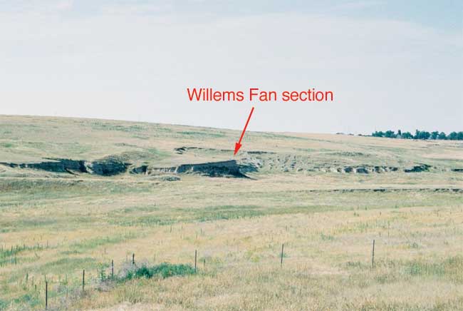
The Willems alluvial fan is on the valley floor of South Fork Beaver Creek (Fig. 2). Lateral migration of South Fork Beaver Creek has removed the distal end of the fan, leaving small remnants of the northern and southern lobes. The fan formed at the mouth of an intermittent, first-order stream that drains about 2 km2 of the loess mantled uplands. Fan-head entrenchment has created a deep channel down the axis of the fan.
Figure 2--Location of Willems fan shown on a digital elevation map of Sherman Co., KS.
The natural vegetation of the High Plains is short-grass prairie (Küchler, 1964). Blue gamma (Bouteloua gracilis) and buffalograss (Bouchloe dactyloides) are the dominant grass species in the region (Küchler, 1974). Naturally occurring trees are scarce and are generally restricted to large streams. Riparian forests are comprised of cottonwoods (Populus deltoides), hackberry (Celtis occidentalis), willow (Salix sp.), and elm (Ulmus sp.).
The High Plains region has a continental climate characterized by low annual precipitation and seasonal extremes in temperature. Average annual precipitation in Sherman County is 43.18 cm (Angell et al., 1973). Low annual precipitation is the result of the orographic effect from the adjacent Rocky Mountains. Rainfall is variable, with 75% of the annual precipitation falling from April to September (Angell et al., 1973). Similarly, years of drought are often followed by periods of excessive annual rainfall. Increased aridity reduces vegetative cover and increases fire frequency, two factors that contribute to landscape instability and erosion (Mandel, 2006b).
Mean daily temperatures vary greatly throughout the year in the study area. Extremes in temperature are likely the result of low precipitation, low humidity, and high elevation (Angell et al., 1973). Summers in Sherman County are hot, with average daily maximum temperatures of 33.1° C and 32.2° C in July and August, respectively. Winters are cold, with average daily minimum temperatures of -7.5° C and -9.05° C in December and January, respectively (Angell et al., 1973).
A 6 m thick section of the Willems fan was cleaned with a shovel in order to provide a fresh, unweathered face for sampling and description. Soil and sediment descriptions were performed by Dr. Rolfe D. Mandel using standard terminology and procedures outlined by Soil Survey Staff (1993) and Birkeland (1999). Soil matrix colors were described using a Munsell book. Soil descriptions included descriptions of root channels, krotovinas, clay films, mottling, and concretions when present. Carbonate morphology was defined according to the classification scheme of Birkeland (1999).
Sedimentary units were numbered consecutively, beginning with Unit I at the bottom of the section. Also, soils were numbered consecutively, beginning with 1, the modern surface soil, at the top of the section. However, in the soil-horizon designations, buried soils were numbered consecutively from the top of a section downward, with the number following the suffix "b." For example, the A horizons of the two superposed buried soils are numbered Akb1 and Akb2 from top to bottom.
Soil samples were collected at 10 cm intervals. Sixty samples were collected and transported to the University of Kansas for analysis. Four additional soil samples were taken at depths of 207-217, 284-294, 450-460, and 505-515 cm and sent to the Illinois State Geological Survey for 14C dating of total decalcified organic carbon. Land snails at the bottom of the section were collected for future radiocarbon dating (table 1).
Table 1--Radiocarbon ages for the Willems Fan
| Lab. No. | Material Assayed |
Depth (cm) |
δ13C (%) |
14C Age (yr. B.P.) |
Cal. Age (yr. B.P.) |
Median Cal. Age |
|---|---|---|---|---|---|---|
| ISGS-6161 | SOM | 207-217 | -16.0 | 6540±70 | 7172-7666 | 7440 |
| ISGS-6162 | SOM | 284-294 | -16.9 | 9290±70 | 10,195-11,069 | 10,496 |
| ISGS-6164 | SOM | 450-460 | -16.9 | 10,390±70 | 11,764-12,759 | 12,275 |
| ISGS-6165 | SOM | 505-515 | -20.1 | 10,750±70 | 12,243-12,993 | 12,748 |
Soil samples were processed at the Kansas Geological Survey for grain size, carbon isotope, and organic carbon analyses. The samples were dried at 50°C for two days and then crushed using a mortar and pestle. Each sample was treated with 5% hydrochloric acid solutions until pH was acidic and CaCO3 was removed. Repeated rinsing and drying of the samples was performed until a neutral pH was reached. An additional rinse in 30% hydrogen peroxide was necessary to remove organic matter for samples undergoing particle-size-analyses.
Sixty samples were submitted to the University of Kansas W. M. Keck Paleoenvironmental and Environmental Stable Isotope Laboratory for δ13C analysis of soil organic matter (SOM). Soil samples and standards were weighed and packaged in 4x6 mm tins. Soil samples were then combusted using a Costech ECS 1040 elemental analyzer. With helium acting as a carrier gas, SOM was converted to CO and CO2 at temperatures reaching 1800°C, with excess CO being catalyzed to quantitative CO2 using a cupric oxide reactor. Excess oxygen used during the combustion phase was consumed through a second reactor comprised of elemental copper. The sample CO2 was then passed on via the helium stream directly to a Finnigan MAT 253 isotope ratio mass spectrometer for raw δ13C analysis. Final corrected δ13C data were reported versus the VPDB scale by generating a calibration curve from the measurement of primary standards of IAEA-600 (sucrose), USGS-24 (graphite), and ANU (sucrose) from the National Institute of Standards (NIST), and a dogfish muscle from the National Research Council of Canada. A soil standard from NIST (SRM 2711 Montana Soil) and a yeast standard were analyzed as part of quality control measures. Typical R2 values generated by calibration curves are 0.9997 or better.
Thirty samples were taken to the Department of Earth Sciences at the University of Missouri-Kansas City for particle-size analysis. A Beckman Coulter Counter LS2000 was used to determine the diameters and percent volume of grains within each sample. The particle size data were arranged into grain-size classes proposed by Wentworth (1922).
The Willems Fan is comprised mainly of yellowish brown (10YR 6/4, dry) to dark grayish brown (10YR 4/2, dry) silt loam (Table 2). Yellowish brown (10YR 6/4, dry), sandy lenses are present within the lower 10 cm of the section.
Three sedimentary units were identified in the section at the Willems fan (Fig. 3). The lowest unit, Unit I, is at a depth of 450-600 cm and consists of very fine sandy loam grading upward to light silty clay loam. A paleosol (Soil 3) with Ak-Bk-BCk horizonation is developed in Unit I. Soil 3 has an overthickened, dark grayish brown (10YR 4/2, dry), cumulic Ak horizon above a Bk horizon with stage I carbonate morphology. Organic carbon from the upper and lower 10 cm of Soil 3 yielded radiocarbon ages of 10,390±70 14C yr. B.P. and 10,750±70 14C yr. B.P., respectively. Hence, slow sedimentation accompanied by soil development occurred on the fan between ca. 10,750 and 10,400 14C yr. B.P. Soil 3 was buried by alluvium composing Unit II soon after ca. 10,400 14C yr. B.P.Table 2--Description of the Willems fan section.
| Depth (cm) |
Soil Horizon |
Description |
|---|---|---|
| 0-12 | A | Brown (10YR 5/3) silt loam, dark brown (10YR 4/3) moist; weak medium, fine and granular structure; hard; many fine and very fine roots; many worm casts and open worm burrows; common ant burrows; gradual smooth boundary. |
| 12-32 | Bw | Pale brown (10YR 6/3) silt loam, brown (10YR 5/3) moist; weak fine subangular blocky structure; hard; common fine and very fine pores; many fine and very fine roots; many worm casts and open worm burrows; common ant burrows; gradual smooth boundary. |
| 32-50 | Bk1 | Pale brown (10YR 6/3) silt loam, brown (10YR 5/3) moist; weak fine subangular blocky structure; common fine and very fine pores; many fine and very fine roots; many worm casts and open worm burrows; common ant burrows; gradual smooth boundary. |
| 50-137 | Bk2 | Pale brown (10YR 6/3-6/4) silt loam, brown (10YR 5/3-5/4) moist; weak medium prismatic structure parting to weak fine subangular blocky; friable; common very fine threads of CaCO3; common fine/ very fine pores; few fine films of CaCO3; few worm casts and open worm burrows; few ant burrows; few fine and very fine roots; gradual smooth boundary. |
| 137-167 | Bk3 | Brown (10YR 5/3) silt loam, dark brown (10YR 4/3) moist; weak fine prismatic structure parting to weak, fine subangular blocky; friable; common films and threads of CaCO3; many fine and very fine pores; common worm casts and open worm burrows; few very fine roots; gradual smooth boundary. |
| 167-192 | BCk | Brown (10YR 5/3) silt loam, dark brown (10YR 4/3) moist; very weak fine subangular block structure; friable; common fine threads and few films of CaCO3; many fine and very fine pores; few worm casts and open worm burrows; gradual smooth boundary. |
| 192-207 | C | Stratified brown (10YR 5/3), pale brown (10YR 6/3), and brown (10YR 5/4) silt loam with brown (10YR 5/4) and light yellowish brown (10YR 6/4) fine sandy loam, loamy fine sand and fine sand; massive and friable silt beds, coarser beds are single grained; common fine threads of CaCO3; common very fine and few fine pores; clear smooth boundary. |
| 207-269 | Akb1 | Dark grayish brown (10YR 4/2) silt loam, very dark grayish brown (10YR 3/2) moist; weak, fine subangular blocky structure parting to moderate, fine and medium granular; hard; many films and threads of CaCO3; many worm casts and open worm burrows; many fine, medium and coarse pores; few root paths filled with pale brown (10YR 6/3) silt loam; few krotovina 3-5cm in diameter filled with yellowish brown (10YR 5/4) and brown (10YR 5/3) silt loam; few very fine roots; gradual smooth boundary. |
| 269-284 | Ak2b1 | Dark gray (10YR 4/1) to dark grayish brown (10YR 4/2) silt loam very dark grayish brown (10YR 3/2) moist; weak, fine subangular blocky structure parting to moderate, fine and medium granular; hard; many films and threads of CaCO3; many worm casts and open worm burrows many fine medium and coarse pores; few root paths filled with pale brown (10YR 6/3) silt loam; few krotovina 3-5cm in diameter filled with yellowish brown (10YR 5/4) and brown (10YR 5/3) silt loam; very few fine roots; clear smooth boundary. |
| 284-304 | Ak3b1 | Dark grayish brown (10YR 4/2) silt loam, very dark grayish brow (10YR 3/2) moist; weak, fine subangular blocky structure parting to moderate, fine and medium granular; hard; many films and threads of CaCO3; many worm casts and open worm burrows many fine medium and coarse pores; few root paths filled with pale brown (10YR 6/3) silt loam; few krotovina 3-5cm in diameter filled with yellowish brown (10YR 5/4) and brown (10YR 5/3) silt loam; very few fine roots; clear smooth boundary. |
| 304-314 | ABkb1 | Dark brown (10YR 4/3) silt loam, Dark brown (10YR 3/3) moist; weak fine subangular blocky structure; friable; few threads of CaCO3; few worm casts and open worm burrows; common fine and very fine pores, few root paths as above; few very fine roots; gradual smooth boundary. |
| 314-359 | Bk1b1 | Brown (10YR 5/3) silt loam, dark brown (10YR 4/3) moist; weak, medium prismatic structure parting to weak, fine, subangular blocky; few fine threads of CaCO3; friable; many fine and very fine pores; few worm casts and open worm burrows; few very fine roots; few root paths as above; gradual smooth boundary. |
| 359-379 | Bk2b1 | Brown (10YR 5/2-5/3) silt loam, dark brown (10YR 4/2-4/3) moist; weak medium prismatic structure parting to weak, fine, subangular blocky few fine threads of CaCO3; friable; many fine and very fine pores few worm casts and open worm burrows; few very fine roots; few root paths as above; gradual smooth boundary. |
| 379-406 | Bk3b1 | Brown (10YR 5/3) silt loam, dark brown (10YR 4/3) moist; weak Medium and fine prismatic structure parting to weak, fine subangular blocky; common fine threads and few fine films of CaCO3; common fine and very fine pores, friable, with very fine roots; few worm casts and open worm burrows; few root paths as above; clear smooth boundary. |
| 406-421 | Bk4b1 | Dark grayish brown (10YR 4/2-4/3) heavy silt loam, very dark grayish Brown (10YR 3/2-3/3) moist; weak, medium and fine prismatic structure parting to weak, fine subangular blocky; hard; common films and threads of CaCO3; common fine and very fine pores; few worm casts and open worm burrows; few very fine roots; few root paths as above; gradual smooth boundary. |
| 421-450 | BCkb1 | Faintly stratified dark grayish brown (10YR 4/2) silt loam, very dark grayish brown (10YR 3/2) moist, and brown (10YR 5/3) silt loam, dark brown (10YR 4/3) moist; very weak fine prismatic structure parting to very weak, fine subangular blocky; friable; common films and threads of CaCO3; common fine and very fine pores; few worm casts and open worm burrows; few very fine roots; few root paths as above; abrupt wavy boundary. |
| 450-505 | Akb2 | Dark grayish brown (10YR 4/2) heavy silt loam to light silty clay loam, very dark grayish brown (10YR 3/2) moist; weak, fine subangular blocky structure parting to moderate, medium and fine granular; slightly hard; common very fine threads and few fine films of CaCO3; few fine silicious pebbles scattered through the matrix; common fine and very fine pores; few worm casts and open worm burrows few root paths as above; common insect burrows filled with brown (10YR 5/3) silt loam; gradual smooth boundary. |
| 505-530 | Bk1b2 | Dark brown (10YR 4/3) light silty clay loam, (10YR 3/3) moist; weak fine prismatic structure; firm; hard when dry; very fine threads of CaCO3; common dark grayish brown (10YR 4/2) organic coats on ped faces; few discontinuous thin clay films on ped faces; common fine and very fine pores; few very fine roots; few root paths as above; gradual smooth boundary. |
| 530-560 | Bk2b2 | Brown (10YR 5/3) silt loam, dark brown (10YR 4/3) moist; weak, medium prismatic structure parting to moderate, fine subangular blocky; hard; few fine threads of CaCO3; many very fine and common fine pores; few root paths as above; gradual smooth boundary. |
| 560-570 | Bk3b2 | Yellowish brown (10YR 5/4) loam, (10YR 4/4) moist; weak medium prismatic structure parting to moderate, fine subangular blocky; common very fine threads of CaCO3; many very fine and common fine pores; few roots as above; gradual smooth boundary. |
| 570-600+ | BCkb2 | Yellowish brown(10YR 6/4) very fine sandy loam; (10YR 5/4) moist; very weak medium prismatic structure parting to very weak, subangular blocky; friable; many fine and very fine pores; common very fine threads of CaCO3. |
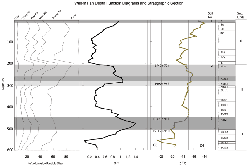
Figure 3--Soils and radiocarbon ages (14C yr. B.P.) within the Willems fan.
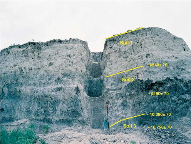
Unit II is at a depth of 207 to 450 cm and consists entirely of silt loam. A paleosol (Soil 2) with Ak-Bk-BCk horizonation is developed in Unit II and welded to the top of Soil 3. Soil 2 is comprised of three overthickened, dark grayish brown (10YR 4/2, dry) and dark gray (10YR 4/1, dry) Ak horizons above a Bk horizon with stage I carbonate morphology. Organic carbon from the upper and lower 10 cm of Soil 2 yielded radiocarbon ages of 6540±70 and 9290±70 14C yr. B.P., respectively. Slow sedimentation accompanied by soil development occurred on the fan between ca. 9300 and 6550 14C yr. B.P. Soil 2 was buried by alluvium composing Unit I soon after ca. 6550 14C yr. B.P.
Unit III extends from the surface to a depth of 207 cm and consists entirely of silt loam. A modern surface soil (Soil 1) with A-Bw-Bk-C horizonation is developed in Unit III and welded to the top of Soil 2. Soil 1 has a brown (10YR 5/3, dry) A horizon and a pale brown (10YR 6/3-6/4, dry) Bk horizon with stage I carbonate morphology. Unit III aggraded and Soil 1 formed sometime after ca. 6550 14C yr. B.P.
The entire fan exhibits a fining-upward trend, from very fine sandy loam at the bottom to silt loam at the top of the section (Fig. 4; Table 3). Also, there are three fining-upward sequences; all associated with the major sedimentary units. There are two possible explanations for these trends. One explanation is that each fining-upward sequence represents a reduction in energy associated with climate change. A reduction in rainfall would have reduced the volume of runoff supplied to the fan. As energy waned in the fan system, the sediments would have become finer-grained.
A second explanation is that the fining-upward sequences represent cycles of fan-head entrenchment. At the beginning of a cycle, coarser sediment would be delivered to the surface of the fan. As entrenchment continued, aggradation would only occur when runoff spilled out of the trench, depositing its fine-grained suspended load to the fan surface.
Figure 4--Particle-size distribution at the Willems fan.
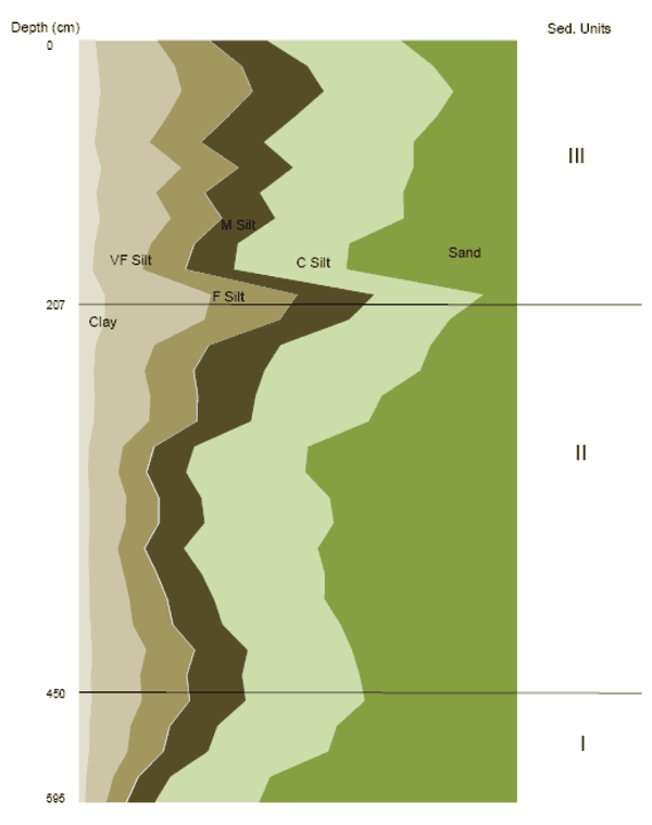
Table 3--Grain-size data for the Willems fan section.
| Depth1 (cm) |
Unit | Clay % |
Silt % | Sand % |
Textural Class2 |
||||
|---|---|---|---|---|---|---|---|---|---|
| V. Fine | Fine | Medium | Coarse | Silt | |||||
| 5-15 | III | 4.3 | 13.7 | 11.8 | 13.3 | 30.5 | 69.3 | 26.1 | SiL |
| 25-35 | III | 5.0 | 17.2 | 15.0 | 15.1 | 28.7 | 76.0 | 19.0 | SiL |
| 45-55 | III | 5.4 | 18.2 | 16.0 | 16.4 | 29.6 | 80.1 | 14.4 | Si |
| 65-75 | III | 4.9 | 15.5 | 13.6 | 15.4 | 32.3 | 76.8 | 18.3 | SiL |
| 85-95 | III | 4.1 | 12.3 | 11.5 | 14.5 | 34.1 | 72.3 | 23.5 | SiL |
| 105-115 | III | 5.7 | 17.9 | 12.9 | 12.5 | 27.5 | 70.8 | 23.3 | SiL |
| 125-135 | III | 4.5 | 13.3 | 10.9 | 12.7 | 32.7 | 69.6 | 25.8 | SiL |
| 145-155 | III | 5.3 | 15.8 | 11.5 | 12.3 | 29.4 | 68.9 | 25.2 | SiL |
| 165-175 | III | 4.1 | 12.5 | 9.7 | 10.0 | 25.4 | 57.6 | 38.3 | SiL |
| 195-205 | III | 3.7 | 11.0 | 9.6 | 11.1 | 25.7 | 57.4 | 38.9 | SiL |
| 205-215 | II | 6.5 | 23.9 | 19.5 | 17.7 | 24.9 | 86.0 | 7.5 | Si |
| 215-225 | II | 6.4 | 22.4 | 17.0 | 15.9 | 22.9 | 78.2 | 15.4 | SiL |
| 225-235 | II | 4.3 | 13.0 | 12.2 | 16.4 | 34.3 | 76.0 | 19.1 | SiL |
| 245-255 | II | 3.9 | 11.3 | 11.0 | 16.2 | 35.6 | 74.0 | 22.0 | SiL |
| 265-275 | II | 4.1 | 12.4 | 10.6 | 13.3 | 28.8 | 65.1 | 30.8 | SiL |
| 285-295 | II | 3.9 | 12.3 | 10.6 | 12.5 | 26.9 | 62.3 | 33.8 | SiL |
| 305-315 | II | 2.8 | 7.5 | 6.9 | 9.3 | 25.9 | 49.5 | 47.7 | SL |
| 325-335 | II | 2.6 | 6.6 | 6.2 | 9.1 | 27.2 | 49.1 | 48.3 | SL |
| 345-355 | II | 3.0 | 8.0 | 7.2 | 9.8 | 29.3 | 54.3 | 42.7 | SiL |
| 365-375 | II | 3.0 | 7.8 | 7.4 | 10.5 | 29.5 | 55.2 | 41.7 | SiL |
| 385-395 | II | 2.7 | 6.3 | 5.9 | 9.1 | 30.6 | 51.9 | 45.4 | SiL |
| 405-415 | II | 2.9 | 7.6 | 7.4 | 10.3 | 28.1 | 53.3 | 43.8 | SiL |
| 425-435 | II | 3.0 | 8.8 | 8.4 | 10.8 | 25.2 | 53.2 | 43.9 | SiL |
| 445-455 | II | 3.2 | 9.4 | 8.9 | 11.5 | 26.9 | 56.6 | 40.2 | SiL |
| 465-475 | I | 3.5 | 12.0 | 10.8 | 12.2 | 23.8 | 58.9 | 37.6 | SiL |
| 485-495 | I | 3.3 | 10.9 | 10.4 | 12.7 | 26.8 | 60.8 | 35.9 | SiL |
| 505-515 | I | 3.4 | 11.1 | 10.7 | 12.9 | 27.2 | 61.9 | 34.7 | SiL |
| 525-535 | I | 2.9 | 9.0 | 8.7 | 11.0 | 27.3 | 56.0 | 41.1 | SiL |
| 545-555 | I | 2.9 | 8.5 | 7.9 | 10.3 | 27.5 | 54.2 | 43.0 | SiL |
| 565-575 | I | 2.2 | 5.9 | 5.4 | 7.4 | 22.8 | 41.5 | 56.3 | SL |
| 585-595 | I | 2.0 | 4.5 | 4.4 | 6.6 | 23.7 | 39.2 | 58.8 | SL |
| 1 Sample Depth 2 Textural Classes: Si=Silt; SiL=Silt loam; SL=Sandy loam |
|||||||||
The carbon isotopic composition of plant material depends on the photosynthetic pathway of the plant. Plants that metabolize using the Calvin cycle (C3 plants) have δ13C values between -23% and -34%, while the less depleted C4 plants have δ13C values between -13% and -23% (Faure et al., 2005). δ13C values also reflect climatic conditions. Within the Great Plains, C3 plants dominate in areas with cool, moist climates, and C4 plants are characteristic of areas with warm climates. Because plant material accumulates in soil, the δ13C values of soil carbon throughout a stratigraphic section can be used to determine changes in vegetation and, therefore, changes in climate.
The δ13C graph shows an overall trend towards less depleted values of 13C (Fig. 5). An abrupt decrease in the δ13C values occurs at a depth of 560-570 cm, early on in fan development. This cooling event was followed by a steady increase in δ13C values, which was initiated sometime before 10,750±70 14C yr B.P and ended by 6540±70 14C yr B.P. After 6540±70 14C yr B.P, δ13C values abruptly decreased, but were again followed by an increasing trend towards higher δ13C values. Continued warming after 6450±70 14C yr B.P. is reflected throughout the modern soil.Three major episodes of fan sedimentation were recorded in the section at the Willems fan. Episodes of sedimentation are marked by pedogenically unaltered sediment, while episodes of stability are marked by two buried soils and the surface soil. All three soils developed at the top of upward-fining sequences and are marked by an increase in organic carbon content (Fig. 5).
Figure 5--Grain size distribution, percentage carbon and δ13C data plotted with depth in relation to the soil stratigraphic section.
Willems fan sedimentation began during the Pleistocene-Holocene transition. The end of the Ice Age brought about a warmer climate and changes in vegetation. Warming and drying are credited for the destabilization of the loess-mantled uplands that provided silty sediment to the streams.
Sedimentation was slow throughout the early Holocene, which resulted in cumulic soil formation between 10,750±70 and 10,390±70 14C yr B.P (Soil 3). Cumulic soils are products of quasi-stability, where depositional rates were slow enough for soil formation to occur, often resulting in overthickened A horizons (Mandel, 2006a, 2008). This period of early-Holocene cumulic soil formation is recognized at other sites in the region and is the result of low-magnitude flooding during the Pleistocene-Holocene transition, including the Younger Dryas (Mandel, 2008). The Younger Dryas is an early-Holocene cooling and drying event, which is represented by Soil 3, where the lowest δ13C values were recorded.
A second episode of slow sedimentation accompanied by cumulic soil development (Soil 2) occurred between 10,390±70 and 6540±70 14C yr B.P. Aggradation of Unit II ceased by ca. 6550 14C yr B.P. and Soil 2 was buried soon after that time.
In Unit II, there is a general upward trend towards heavier δ13C values, indicating an increase in carbon supplied by warm-season C4 grasses (Fig. 5). However, the δ13C values suggest that there was an increase in C3 vegetation between 9290±70 and 6540±70 14C yr B.P.; hence, the climate became cooler and possibly wetter. Cooling coincides with the formation of Soil 2 and therefore, upland stability. Slow sedimentation during the period of soil formation may reflect reduced sediment yields from the uplands and therefore relative landscape stability.
The final episode of sedimentation began sometime after 6540±70 14C yr B.P. Sedimentation ended with the development of the modern soil at the top of Unit III. Based on trends among alluvial fans in the Central Plains (see Mandel, 1995, 2006a), the modern fan surface probably became stable after 3000 14C yr B.P., when the fan reached a geomorphic threshold and the fan-head trench incised its channel.
Aggradation of Unit III coincides with the warming and drying period known as the Altithermal. The Altithermal peaked around ca. 7000 and ended around ca. 4000 B.P (Mandel, 2006a). In the modern soil, δ13C trend towards maximum δ13C values, suggesting increased warming and perhaps aridity (Fig. 5). The environment became dominated by C4 grasses, which in western Kansas corresponds to dominance by short-grass prairie. A reduction in plant cover and an increase in fire frequency during the Altithermal probably destabilized the uplands (Mandel, 1995). Infrequent but intense rainfall resulted in large sediment loads being deposited on the Willems fan.
In the case of the Willems fan, sedimentation appears to coincide with bioclimatic change. Sedimentation occurred during known intervals of aridification (i.e., the Altithermal and Younger Dryas), which were detected in the δ13C data for the fan.
Alluvial fan development was underway sometime before ca. 10,700 14C yr. B.P. Units I and II in the fan aggraded slowly and sedimentation was accompanied by cumulic soil formation. Slow sedimentation continued between ca. 10,700 and 6550 14C yr B.P., a period characterized by gradual warming as indicated by the δ13C data. A final pulse of sedimentation after ca. 6550 14C yr B.P. was rapid and uninterrupted by soil formation until the modern surface soil (Soil 1) developed at the top of the section. Rapid sedimentation after ca. 6550 14C yr B.P. coincided with warming and drying during the Altithermal and is well represented in the δ13C data for the fan. Warming and drying during the mid-Holocene destabilized the loess-mantled uplands resulting in high sediment yields. Silty alluvium derived from the uplands was deposited on the alluvial fan. Hence, the evolution of the Willems fan represents a geomorphic signal for late-Quaternary bioclimatic change on the High Plains.
Alley, R.B., Meese, D.A., Shuman, C.A., Gow, A.J., Taylor, K.C., Grootes, P.M., White, J.W.C., Ram, M., Waddington, E.D., Mayewski P.A., and Zielinski, G.A., 1993, Abrupt Increase in Snow Accumulation at the End of the Younger Dryas Event: Nature, v. 362, p. 527-529.
Angell, R.C., Youberg, C.F., Bell, E.L., and Hagihara, J.S., 1973, Soil Survey of Sherman, County Kansas: Soil Conservation Service, United States Department of Agriculture in cooperation with the Kansas Agricultural Experiment Station, Government Printing Office, Washington, D.C.
Baker, R.G., Fredlund, G.G., Mandel, R.D., and Bettis, E.A. III., 2000, Holocene Environments of the Central Great Plains: Multi-Proxy Evidence from Alluvial Sequences, Southeastern Nebraska: Quaternary International, v. 67, p. 75-88.
Birkeland, P.W., 1999, Soils and Geomorphology, Third Edition: Oxford University Press, 430 p.
Buchanan, R., 1984, Kansas Geology; An Introduction to Landscapes, Rocks, Minerals, and Fossils: University Press of Kansas, 228 p.
Cook, E.R., Seager, R., Cane, M.A., and Stahle, D.W., 2007, North American Drought: Reconstructions, Causes, and Consequences: Earth Science Reviews, v. 81, no. 1-2, p. 93-134.
Faulkner, D.J., 2002, Alluvial Fans as Records of Holocene Sediment Yield in the Central Great Plains of Southwest Nebraska. Physical Geography: 23, p. 343-365.
Faure, G., and Mensing, T.M., 2005, Isotopes: Principles and Applications, 3rd Edition: John Wiley & Sons, Inc., 897 pp.
Fenneman, N.M., 1931, Physiography of the Western United States. McGraw-Hill, New York, 534 pp.
Hall, S.A, and Lintz, C., 1984, Buried Trees, Water Table Fluctuations, and 3000 Years of Changing Climate in West-Central Oklahoma: Quaternary Research, v. 22, no. 1, p. 129-133.
Küchler, A.W., 1974, A New Vegetation Map of Kansas: Ecology: v. 55, no. 3, p. 586-604.
Mandel, R.D., 1990, Geomorphology and Stratigraphy of the Stigenwalt Site; in, The Archeology of the Stigenwalt Site 14LT351, Randy Thies, ed.: Kansas State Historical Society, Contract Archeology Series, Publication Number 7, pp. 138-145.
Mandel, R.D., 1992, Soils and Holocene Landscape Evolution in Kansas; in, Soils in Archaeology, V.T. Holliday, ed.: Smithsonian Press, pp. 41-100.
Mandel, R.D., 1995, Geomorphic Controls of the Archaic Record in the Central Plains of the United States; in, Archaeological Geology of the Archaic Period in North America, E.A. Bettis III, ed.: Geological Society of America, Special Paper 297, pp. 37-66.
Mandel, R.D., 2006a, The Effects of Late Quaternary Landscape Evolution on the Archaeological Record of Kansas; in, Kansas Archaeology, W.E. Banks and R.J. Hoard, eds.: University of Kansas Press, Lawrence, p. 28-44.
Mandel, R.D., 2006b, Late Quaternary and Modern Environments in Kansas; in, Kansas Archaeology, W.E. Banks and R.J. Hoard, eds.: University of Kansas Press, Lawrence, p. 10-26.
Mandel, R.D., 2008, Buried Paleoindian-Age Landscapes in Stream Valleys of the Central Great Plains, USA: Geomorphology, v 101, no. 1-2, p. 342-361.
Mandel, R.D., and Hofman, J.L., 2006, Trip 4, Stop 2: Simshauser site (14KY102) and Mattox Draw; in, Guidebook of the 18th Biennial Meeting of the American Quaternary Association, R.D. Mandel, ed.: Kansas Geological Survey, Technical Series 21, p. 4-9-4-16.
May, D.W., 1989. Late Holocene Valley-Bottom Aggradation and Erosion in the South Loup River Valley, Nebraska: Physical Geography, p. 117-120.
Soil Survey Staff, 1993. Soil Survey Manual, Handbook 18: Soil Conservation Service, U.S. Department of Agriculture, Washington, D.C.
Wentworth, C.K., 1922. A Scale of Grade and Class Terms for Clastic Sediments: The Journal of Geology, v. 30, p. 377-392.
Kansas Geological Survey, Geology
Updated March 1, 2010
Comments to webadmin@kgs.ku.edu
The URL for this page is http://www.kgs.ku.edu/Publications/OFR/2009/OFR09_21/index.html