Kansas Geological Survey, Open-file Report 2005-1
by
Rolfe D. Mandel
Kansas Geological Survey
KGS Open File Report 2005-1
Report prepared for
Ellis & Associates, Inc., Minneapolis, Minnesota
This report contains the results of a geoarchaeological survey of the proposed Cunningham Recycle project area in Kingman and Pratt counties, Kansas. The primary objectives of this investigation were to (1) determine whether prehistoric cultural deposits are present on the land surface in the project area; (2) determine whether buried archaeological deposits are likely to be preserved in the project area, and (3) test selected localities for buried archaeological deposits by looking for evidence, such as artifacts and cultural features, in backhoe trenches.
The project area is on the southern fringe of the Arkansas River Lowlands of Fenneman's (1931) Great Plains physiographic province. The Arkansas River Lowlands follows the Arkansas River from the Kansas-Colorado border in Hamilton County eastward to the Kansas-Oklahoma border in Cowley County. The Arkansas River meandered across this region throughout the Quaternary, leaving a complex record of alluvial deposits that mostly consist of sand and gravel. In many areas of the Arkansas River Lowlands, winds swept the sands into low, rolling dunes.
Fenneman (1931) and Schoewe (1949) divided the Arkansas River Lowlands into the Finney Lowland and Great Bend Lowland. The project area is in the latter region. The Great Bend Lowland is an undulating plain with little relief. Fent (1950) suggested that the great bend of the Arkansas River migrated laterally from the south to its present position via successive captures by its own northern tributaries. The surficial geology of the Great Bend Lowland is dominated by unconsolidated Quaternary deposits of alluvial and eolian origin. The alluvial deposits have a maximum thickness of about 120 m and consist of sediment derived from local and distant sources. In many areas, sandy surficial deposits have been reworked by the wind. Dunes and dune fields have formed where this sand is thickest (Schoewe, 1949:293; Rosner, 1988; Johnson, 1991; Logan et al., 1993; Arbogast, 1995). An extensive sand-dune belt that is about 8 km wide occurs on the north side of the Arkansas River northeast of Hutchinson and trends southeast between the Arkansas and Little Arkansas rivers. Smaller dune fields are scattered throughout the Great Bend Lowland, including the area of northwest Kingman County and northeast Pratt County.
The project area is in the South Fork Ninnescah River valley. There are at least four geomorphic surfaces in the river valley between the towns of Kingman and Pratt, Kansas: the modern floodplain (T-0) and three alluvial terraces numbered T-1 through T-3 from lowest to highest (Mandel, 2005). The three lowest geomorphic surfaces (T-0, T-1, and T-2) collectively form the valley floor of the South Fork Ninnescah River. The T-3 terrace is high in the valley landscape, standing 12-14 m above the modern floodplain. Holocene alluvium is stored beneath the T-0, T-1, and T-2 surfaces, and Pleistocene alluvium (Wisconsinan?) is beneath the T-3 surface. The project area is on the T-3 terrace.
The soils on the T-3 terrace within the project area are mapped as the Albion series (Horsch et al., 1968; Hoffman and Glum, 1979). During the present investigation, subsurface testing revealed that the soils are variants of the Albion series. For example, in Section 24 of the project area, a soil more or less resembling the Albion series has stage I+ carbonate morphology in the Btk horizon. However, Albion soils are typically acid and do not have secondary carbonate features. In Section 19 of the project area, a soil classified as Albion has a Bw horizon, whereas the Albion series typically have Bt horizons. Nevertheless, like the Albion series, all of the soils in the project area are very well drained. Although wetlands occur on the adjacent valley floor of the South Fork Ninnescah River, the soils and underlying sediments (sand and gravel) within the project area are unfavorable for wetlands.
Prior to the early 1980s, most archaeologists working in Kansas and other areas of the Great Plains relied on traditional methods of surface surveys to locate prehistoric cultural deposits. These methods, such as pedestrian surveys and shallow shovel testing, rarely detect buried cultural materials. Bettis and Littke (1987: 3) pointed out that inadequate subsurface sampling in stream valleys led to significant gaps in the record of known prehistoric cultural resources, as well as erroneous conclusions about some aspects of regional cultural history. A number of studies (e.g, Artz 1983, 1985; Mandel 1992, 1994a, 1994b, 1995, 1996, 1997, 2005) have demonstrated that stream valleys have extensive surfaces that are geologically quite young, often post-dating 2000 B.P., and that most of the existing record of prehistoric cultures is deeply buried. They emphasized the need for understanding the age and soil stratigraphy of landform sediment assemblages in order to adequately evaluate stream valleys for archaeological resources. Hence, this study involved subsurface exploration as a component of the archaeological survey.
The field investigation initially involved reconnaissance of the project area. Based on the results of the reconnaissance, two localities within the project area were targeted for subsurface archaeological testing: one locality near the proposed pad area of Well 24-42, and the other locality within the proposed pad area of Well 19-14.
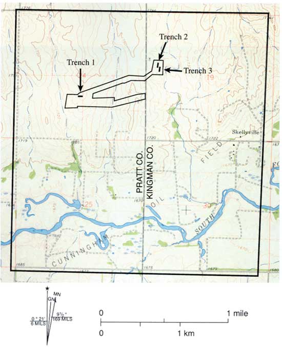
After selecting the locations for subsurface investigation, a surface survey was conducted in the project area. This task involved walking over all locations that will be affected by construction activities (Figure 1).
Figure 1. Topographic map showing the locations of the archeological survey area and backhoe trenches. The map is derived from the U.S.G.S. 7.5 minute Cunningham, KS, Quadrangle.
The next phase of the field investigation involved deep testing with a tractor-mounted backhoe. Three T-shaped trenches were excavated in the project area (Figure 1). Trenches 1 and 2 were excavated to a depth of 1.5 m and Trench 3 was excavated to a depth of 0.7 m. Trench walls were cleaned with a trowel, examined for cultural materials, and described. Sediments and soils exposed in the trenches were described using standard procedures and terminology outlined by Soil Survey Staff (1992) and Birkeland (1999).
Alluvial deposits dating to the late Quaternary are preserved beneath geomorphic surfaces in the project area. Information about the relative age of these deposits, combined with soil-stratigraphic data, was used to predict where buried archeological materials may occur in the landscape.
The determination of geologic potentials for buried cultural deposits is partially based on the soil record. Buried soils represent previous land surfaces that were stable long enough to develop recognizable soil profile characteristics (Mandel and Bettis, 2001). As Hoyer (1980) pointed out, if one assumes that the probability of human use of a particular landscape position was equal for each year, it follows that the surfaces that remained exposed for the longest time would represent those with the highest probability for containing cultural materials. Because buried soils represent these surfaces, evidence for occupation would most likely be associated with them (Mandel and Bettis, 2001). It is important to note, however, that buried cultural deposits, even rich ones, also may be found in sediment that has not been modified by soil development (Hoyer, 1980). Hence the presence/absence of buried soils cannot be used as the sole criterion for evaluating the potentials for buried cultural materials. The mere presence of Holocene deposits beneath a geomorphic surface offers some potential for buried cultural materials.
Southern Half of Section 24, T. 27 S., R. 11 W., Pratt County
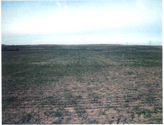
The portion of the project area in the southern half of Section 24 (Pratt County) is on the high Pleistocene terrace (T-3) of the South Fork Ninnescah River. The T-3 terrace has been deeply dissected by gullies and small, first-order drainage elements (draws) that trend south towards the river. The proposed construction site for Well No. 24-42 is on a steep side slope of the westernmost draw in project area (Figure 2). Sheet and rill erosion have stripped off the A and B horizons of the modern soil, exposing Pleistocene sand and gravel (C horizon) at the land surface.
Figure 2. Photograph of the archeological survey area in the NE 1/4 of the SW 1/4 of section 24, T. 27 S., R. 11 W. The view is to the west. The stakes mark the path of the proposed pipeline leading to proposed Well No. 24-42 on the side slope of a draw.
During the geoarchaeological investigation, the proposed construction site for Well No. 24-42, and the surrounding area in the NE 1/4 of the SW 1/4 of Section 24, had a sparse cover of winter wheat. Hence, surface visibility was very good (70-80%) in this area. However, portions of the project area in the northern half of the SE 1/4 of Section 24 were in pasture. The pasture was heavily grazed, and burrowing animals, especially gophers, had destroyed the vegetation in many places. Surface visibility in the pasture was about 30-40%. All localities in the southern half of Section 24 that will be affected by the construction of the proposed withdrawal well and access roads and the emplacement of pipelines were surveyed for cultural materials. No prehistoric artifacts or cultural features were observed on the land surface.
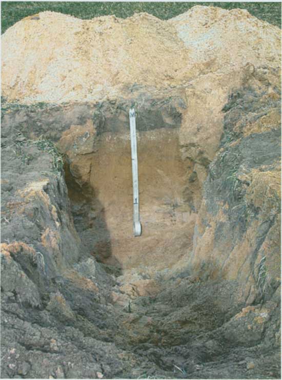
In addition to the surface survey, a 6-m-long backhoe trench (Trench 1) was excavated in the workspace over the proposed pipeline that trends northeast towards the Cunningham STA Site (Figures 1 and 3). The trench was placed on a ridge immediately up-slope from the proposed construction site for Well No. 24-42. The southern edge of a sand dune has encroached upon the northern portion of this ridge. Hence, it was necessary to determine whether eolian sands are present in the project area, and if present, whether they mantle a former surface soil that might contain prehistoric cultural materials.
Figure 3. Photograph of Trench 1 on the T-3 terrace up-slope from proposed well No. 24-42. The view is to the north.
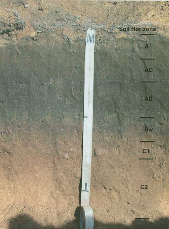
Trench 1 exposed a thin, well-drained surface soil with Ap-Btk-Bt-BC horizonation formed in sandy Pleistocene alluvium (Figure 4 and Table 1); there is no veneer of eolian sand along the path of the proposed pipeline. The Ap horizon is 22 cm thick and is grayish brown (10YR 5/2, dry) fine sandy loam with few granules and fine pebbles. The Btk horizon is 13 cm thick and is brown (10YR 5/3, dry) sandy clay loam with few granules and fine pebbles. There are common fine, soft masses of calcium carbonate and distinct, discontinuous dark grayish brown (10YR 4/2) clay films on ped faces in the Btk horizon. Granules and fine pebbles are scattered through the soil matrix. The underlying Bt horizon is 13 cm thick and is yellowish brown (10YR 5/4) fine sandy loam with few granules and fine pebbles. There are few, discontinuous clay films on ped faces, but clay bridges are common between sand grains. Light yellowish brown (10YR 6/4) loamy fine sand composing the BC horizon grades downward into fine and medium sand (C1 horizon) above stratified coarse sand interbedded with gravel (C2 horizon). The walls of the backhoe trench were cleaned with a trowel and inspected for cultural material, but none was found.
Figure 4. Photograph of the soil profile exposed in Trench 1.
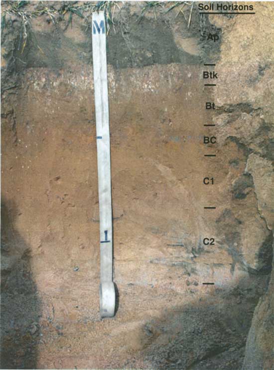
Table 1. Description of the soil profile in Trench 1.
| Landform: High alluvial terrace (T-3) Landscape Position: Ridge between two draws Parent material: Alluvium Slope: 1-2% Land cover: Winter wheat |
||
| Depth (cm) | Soil Horizon | Description |
|---|---|---|
| 0-22 | Ap | Grayish brown (10YR 5/2) fine sandy loam, dark grayish brown (10YR 4/2) moist; very weak fine granular structure; soft, very friable; few granules and fine pebbles; common fine and very fine roots; abrupt wavy boundary. |
| 22-35 | Btk | Brown (10YR 5/3) sandy clay loam, dark brown (10YR 4/3) moist; weak fine subangular blocky structure parting to weak very fine subangular blocky; slightly hard, friable; few distinct discontinuous grayish brown (10YR 5/2) clay films on ped faces; common fine soft masses of calcium carbonate; few granules and fine pebbles; common fine and very fine roots; common worm casts and open worm burrows; gradual smooth boundary. |
| 35-48 | Bt | Light yellowish brown (10YR 6/4) fine sandy loam, yellowish brown (10YR 5/4) moist; weak fine subangular blocky structure parting to weak very fine subangular blocky; slightly hard, friable; few distinct discontinuous grayish brown (10YR 5/2) clay films on ped faces and clay bridges between sand grains; few granules and fine pebbles; common fine and very fine roots; few worm casts and open worm burrows; gradual smooth boundary. |
| 48-56 | BC | Light yellowish brown (10YR 6/4) fine sandy loam, yellowish brown (10YR 5/4) moist; very weak fine subangular blocky structure parting to weak fine granular; soft, friable; few granules and fine pebbles; few fine and very fine roots; gradual smooth boundary. |
| 56-85 | C1 | Light yellowish brown (10YR 6/4) fine and medium sand, yellowish brown (10YR 5/4) moist; single grain; loose; few granules and fine pebbles; gradual smooth boundary. |
| 85-150 | C2 | Stratified light yellowish brown (10YR 6/4), yellowish brown (10YR 5/4), pale brown (10YR 6/3), and brown (10YR 5/3) medium and coarse sand interbedded with gravel; single grain; loose. |
Based on the geomorphic and soils evidence, the potential for buried cultural deposits at the proposed construction site for Well No. 24-42 and in other areas of Section 24 that will be affected by construction activities, including emplacement of pipelines and construction of access roads, is extremely low. Pleistocene alluvium underlying the T-3 terrace is exposed throughout this portion of the project area. Although the numerical age of the T-3 fill is unknown, it pre-dates the Holocene and may be considerably greater than 12,000 years old (Mandel, 2005). Although buried pre-Clovis cultural deposits cannot be ruled out, it is very unlikely that they are present in the project area. Also, there is no evidence of Holocene dune deposits on the T-3 terrace in the southern half of Section 24. Instead, the landscape has been severely eroded by fluvial processes (i.e., the development of gullies and small, intermittent drainage elements) and sheet and rill erosion. Hence, additional subsurface archaeological testing and surface survey are unnecessary in this portion of the project area.
NE 1/4, Section 19, T. 27 S., R. 10 W., Kingman County
The portion of the project area in the NE 1/4 of Section 19 (Kingman County) is on the high Pleistocene terrace (T-3) of the South Fork Ninnescah River. Most of the activity in this area will be associated with the construction of proposed Well No. 19-14. The pad site for this proposed well is on a foot-slope of a small valley containing a small, unnamed, second-order tributary. This tributary valley is inset into the alluvial fill underlying the T-3 terrace of the South Fork Ninnescah River.
Trench 2 was excavated within the proposed workspace surrounding Well No. 19-14 (Figures 1 and 5). This trench was 6 m long and exposed a 28-cm-thick veneer of recent sediment above a soil developed in Pleistocene alluvium. The modern surface soil has a weakly expressed A-AC profile (Figure 6 and Table 2). The A horizon is 15 cm thick and is dark brown (10YR 4/3, dry) fine sandy loam. The AC horizon is 13 cm thick and is brown (10YR 5/3, dry) fine sandy loam. The presence of such a thin, weakly developed surface soil suggests that the veneer of sediment overlying the soil developed in the Pleistocene alluvium is less that 100 years old. This sediment may have been shed from the adjacent slopes (i.e., it is slope wash), or it may be alluvium deposited by the small, second-order stream on the eastern edge of the project area.
Figure 5. Photograph Trench 2 on the T-3 terrace in the construction area of roposed Well No. 19-14. The view is to the northeast.
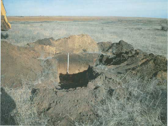
Table 2. Description of the soil profile in Trench 2.
| Landform: High alluvial terrace (T-3) Landscape Position: Foot slope Parent material: Alluvium Slope: 1-2% Land cover: Pasture |
||
| Depth (cm) | Soil Horizon | Description |
|---|---|---|
| 0-15 | A | Dark brown (10YR 4/3) fine sandy loam, dark brown (10YR 3/3) moist; weak fine granular structure; slightly hard, friable; common granules and fine pebbles; many fine and very fine roots; many worm casts and open worm burrows; gradual smooth boundary. |
| 15-28 | AC | Brown (10YR 5/3) fine sandy loam, dark brown (10YR 4/3-3/3) moist; weak fine granular structure; slightly hard, friable; common granules and fine pebbles; many fine and very fine roots; many worm casts and open worm burrows; clear smooth boundary. |
| 28-55 | Ab | Dark brown (10YR 4/3) fine sandy loam, dark brown (10YR 3/3) moist; weak fine granular structure; slightly hard, friable; common granules and fine pebbles; many fine and very fine roots; many worm casts and open worm burrows; few krotovina 5-8 cm in diameter filled with brown (10YR 5/3) fine sandy loam; gradual smooth boundary. |
| 55-70 | Bwb | Yellowish brown (10YR 5/4) loamy fine sand, dark yellowish brown (10YR 4/4) moist; weak fine subangular blocky structure; slightly hard, friable; common granules and fine pebbles; common fine and very fine roots; common worm casts and open worm burrows; gradual smooth boundary. |
| 70-80 | C1b | Light yellowish brown (10YR 6/4) medium and coarse sand, yellowish brown (10YR 5/4) moist; single grain; loose; common pebbles and few cobbles; gradual smooth boundary. |
| 80-150 | C2b | Light yellowish brown (10YR 6/4) medium and coarse sand, yellowish brown (10YR 5/4) moist; single grain; loose; common pebbles. |
Figure 6. Photograph of the soil profile exposed in Trench 2.
The buried soil exposed in Trench 2 has a thin, weakly developed A-Bw profile (Figure 6 and Table 2). The Ab horizon is 27 cm thick and is dark brown (10YR 4/3, dry) fine sandy loam. The cambic (Bwb) horizon is 15 cm thick and is yellowish brown (10YR 5/4, dry) loamy fine sand. Sand and gravel compose the lower 80 cm of the profile (C1 and C2 horizons).
It is likely that the Ab horizon of the buried soil in Trench 2 was at the land surface when the region was settled by Euro-Americans. As such, it is the "Pre-Settlement" soil and was not buried until sometime after the early 1800s. Hence, the buried soil has relatively high geologic potential for containing cultural deposits spanning the past ca. 12,000 years. However, no artifacts or cultural features were observed in the walls of Trench 2.
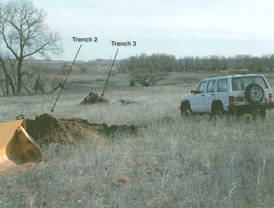
Given the high geologic potential for buried cultural deposits in the area of proposed Well No. 19-14, Trench 3 was excavated about 12 m south of Trench 2 (Figure 7). Trench 3 was 8 m long and 70 cm deep. This trench provided a good "window" for thorough inspection of the buried soil. The walls of the trench were cleaned with a trowel and carefully examined. However, no artifacts or cultural features were observed.
Figure 7. Photograph of Trenches 2 and 3 in the construction area of proposed well No. 19-14.
All locations within Section 19 that will be affected by the construction of the proposed withdrawal well and access roads and the emplacement of pipelines were surveyed for cultural materials. No prehistoric artifacts or cultural features were observed on the land surface.
In sum, the portion of the project area in the NE 1/4 of Section 19 does not appear to have prehistoric cultural deposits on or beneath the land surface. Although there is geologic potential for buried cultural materials, this potential was tested and additional subsurface exploration is unnecessary.
Arbogast, A.F., 1995, Paleoenvironments and Desertification on the Great Bend Sand Prairie in Kansas: Unpublished Ph.D. dissertation, University of Kansas, Lawrence.
Artz, J. A., 1983, The soils and geomorphology of the East Branch Walnut Valley: contexts of human adaptation in the Kansas Flint Hills: Unpublished M.A. thesis, Department of Anthropology, University of Kansas, Lawrence.
Artz, J. A., 1985, A soil-geomorphic approach to locating buried Late-Archaic sites in northeast Oklahoma: American Archaeology, 5:142-150.
Bettis, E. A., III, and Littke, J. P., 1987. Holocene Alluvial Stratigraphy and Landscape Development in Soap Creek Watershed, Appanoose, Davis, Monroe, and Wapello Counties, Iowa: Iowa Department of Natural Resources, Geological Survey Bureau, Open File Report 87-2, Iowa City.
Birkeland, P. W., 1999, Soils and Geomorphology. Oxford University Press, Oxford.
Fenneman, N. M., 1931, Physiography of Western United States. McGraw-Hill Book Co., New York.
Fent, O.S., 1950, Pleistocene drainage history of central Kansas: Transactions of the Kansas Academy of Science, 53:81-90.
Hoffman, B.R., and Glaum, S.A., 1979, Soil Survey of Kingman County, Kansas: Soil Conservation Service, U.S. Department of Agriculture, U.S. Government Printing Office, Washington, D.C.
Horsch, M.L., Hoffman, B.R., and Gier, D.A., 1968, Soil Survey of Pratt County, Kansas: Soil Conservation Service, U.S. Department of Agriculture, U.S. Government Printing Office, Washington, D.C.
Hoyer, B.E., 1980, Geology of the Cherokee Sewer Site, in The Cherokee Excavations: Holocene Ecology and Human Adaptations in Northwestern Iowa, edited by D.C. Anderson and H.A. Semken, Jr.: Academic Press, New York, pp. 21-66.
Johnson, W.C., 1991, Buried soil surfaces beneath the Great Bend Prairie of central Kansas and archaeological implications: Current Research in the Pleistocene 8: 108-110.
Logan, B., Arbogast, A.F., and Johnson, W.C., 1993, Geoarchaeology of the Kansas Sand Prairie: University of Kansas, Museum of Anthropology, Project Report Series No. 83, Lawrence.
Mandel, R. D., 1992, Soils and Holocene landscape evolution in central and southwestern Kansas, in Soils in Archaeology, edited by V. T. Holliday, V. T.: Smithsonian Institution Press, Washington, D. C., pp. 41-117.
Mandel, R. D., 1994a, Geomorphology and stratigraphy of lower Mill Creek valley, Johnson County, Kansas, in Archeological Test Excavations at Six Prehistoric Sites within the Lower Mill Creek Valley, Johnson County, Kansas, edited by T.V. Gillen, R. P. Winham, E. J. Lueck, and L. A. Hanus: Archeology Laboratory, Augustana College, Archeology Contract Series No. 99, Sioux Falls, South Dakota, pp. 96-125.
Mandel, R. D., 1994b, Holocene Landscape Evolution in the Pawnee River Valley, Southwestern Kansas: Kansas Geological Survey, Bulletin 236, Lawrence.
Mandel, R. D., 1995, Geomorphic controls of the Archaic record in the Central Plains of the United States, in Archaeological Geology of the Archaic Period in North America, edited by E. A. Bettis III: Geological Society of America Special, Paper 297, Boulder, Colorado, pp. 37-66.
Mandel, R. D., 1996, Geomorphological Investigation in Support of the Phase I Cultural Resources Survey of Northern Natural Gas Company's Proposed Mullenville-Bushton E-Line Stitches Project in Barton, Edwards, Pawnee, Rice, and Stafford Counties, Kansas: Archeology Laboratory, Augustana College, Sioux Falls, South Dakota.
Mandel, R. D., 2005, Late Quaternary Landscape Evolution in Southeast and South-Central Kansas: Kansas Geological Survey Bulletin, Lawrence, Kansas.
Mandel, R.D., and Bettis, E.A., III, 2001, Use and Analysis of Soils by Archaeologists and Geoscientists: A North American Perspective, in Earth Science in Archaeology, edited by Paul Goldberg, Vance T. Holliday, and C. Reid Ferring: Kluwer Academic/Plenum, Norwell, Massachusetts, pp. 173-204.
Rosner, M.L., 1988, The Stratigraphy of the Quaternary Alluvium in the Great Bend Prairie: Unpublished M.S. thesis, University of Kansas, Lawrence.
Schoewe, W.H., 1949, The geography of Kansas, part 2--physical geography: Transactions of the Kansas Academy of Science, 52: 261-333.
Soil Survey Staff, 1992, Keys to Soil Taxonomy: SMSS Technical Monograph No. 19, Virginia Polytechnic Institute and State University, Blacksburg, Virginia.
Kansas Geological Survey, Geology
Placed online Jan. 24, 2006
Comments to webadmin@kgs.ku.edu
The URL for this page is http://www.kgs.ku.edu/Publications/OFR/2005/OFR05_01/index.html