Kansas Geological Survey, Open-file Report 2000-65
Next page--Methods
Department of Geography
University of Kansas
submitted to
2902 Newmark Drive Champaign, Illinois 61821-1076
Read the PDF version (28.7 MB)
Several years ago, archaeologists recognized that the preserved record of past cultural activities is evidence of, with varying degrees of accuracy, both the articulation of human groups and their environment and the effects of post-occupational processes on the material remains of those activities (e.g., Schiffer, 1976; Binford, 1981; Wood and Johnson, 1978). The database is not inherited in a pristine condition, however, in that the archaeological record is an imperfect mirror of past cultural activities that formed vulnerable, "fossil" configurations, which are in turn usually flawed by a variety of post-depositional processes, both cultural and natural.
We have to realize that the cultural record is limited by erosional destruction of part of the record. As Ager (1973, p. 34) notes, "The sedimentary pile at any one place on the Earth's surface is nothing more than a tiny and fragmentary record of vast periods of Earth history." Bettis and Benn (1984), Gladfelter (1985), Johnson and Logan (1990), and a host of others have made the same observation, but in an archaeological context. At Fort Riley, one has to contend with a record of destructive cut and fill episodes within the valleys and with another of water and wind erosion and downslope displacement of upland loess.
Sampling methods for regional and local archaeological surveys have been articulated by many researchers (e.g., Redman, 1974; Plog, 1976; Warren and O'Brien, 1981). As a function of these traditional approaches, resulting studies generally failed to address directly the pervasive problem of erosion (removal/destruction) and deposition (burial), and how they may skew the visible archaeological record. In recent years, archaeologists and earth scientists have routinely joined ranks to address the issue of geomorphic factors that affect site distributions at all scales.
Geoarchaeological research on Fort Riley represents a high-resolution examination of the alluvial and upland eolian record, with the goal of identifying and mapping the remnants of the sedimentary record that contain the potential for cultural remains. Through the use of radiocarbon dating, alluvial surfaces and fills have been dated and extent of Holocene loess on the uplands approximated.
Geoarchaeological research began with an overview study by D.L. Johnson (1992). On-site work by D.L. Johnson, an assistant and the contractor in June, 1993 involved further reconnaissance, subsurface exploration with a vehicular-mounted coring rig, and documentation and sampling of natural exposures. Eighteen localities, numbered 21-38 and from various landscape positions, were studied through sediment and soil cores. These sites represented various landscape positions within Fort Riley. Of the sites that were cored, all except 21, 26, and 33 extended to bedrock or to the residual soil developed on the bedrock; laboratory analyses were conducted on samples from the cores (D.L. Johnson, 1994). Additional study described the distribution of the loess mantle on the upland and refined the stratigraphy at the Sumner Hill locality, i.e., core site 21 (D.L. Johnson, 1996).
The first evolvement by this investigator centered on paleoenvironmental research. Specifically, tests of the potential for stable isotope ratio analysis (SIRA) of carbon and opal phytolith analysis were conducted to provide proxy time series of climate for the base (W.C. Johnson et al., 1994). Study was carried out on a core extracted from the Sumner Hill locality. Isotopic analysis (δ13C) provided a time series that compares well with a composite of regional carbon isotope data, whereas the opal phytolith record was largely uninterpretable below about 3.5-m depth, i.e., for the lower 8.5 m of the core. On the basis of a recently derived chronostratigraphy of the site (D.L. Johnson, 1996; W.C. Johnson, 1998), the viable portion of the phytolith record does, however, include the time interval related to cultural occupation, i.e., the last 13,000 years or so.
A second part of the environmental reconstruction was designed to consider the record from several sites distributed over the reservation in upland and valley environments. The research design was constructed as to make coincident use of magnetic analysis, SIRA, and analysis of opal phytoliths. Data from this multiparametric approach were of extremely high quality and produced an extractable environmental record.
The next effort continued investigations on the upland loess sequences, but placed emphasis on the alluvial fills of the Republican and Kansas River valleys and selected tributary valleys. Magnetic, isotopic and phytolith studies were continued on the uplands, in conjunction with close-interval radiocarbon dating of selected loess sites. Studies of the alluvial fill focused on the definition and correlation of stratigraphy, combined with radiocarbon dating.
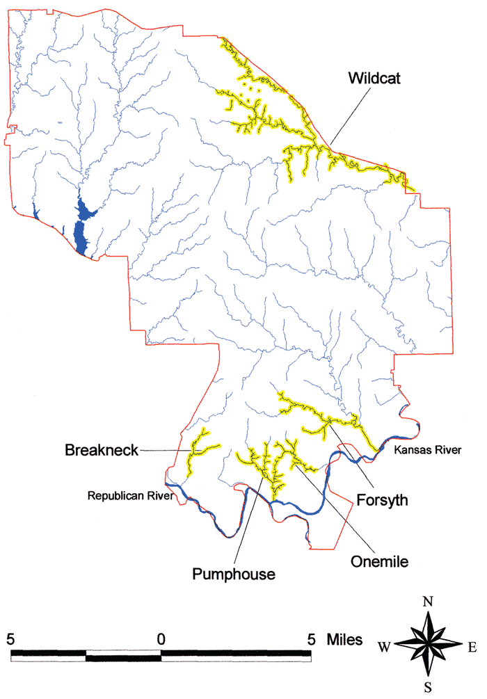
A last focus addressed representation of the stratigraphic and, to a lesser extent, paleo-environmental data in a geographic information system (GIS) context. Distributions of alluvial surfaces and fills and upland loess deposits were rendered, and, from these, probabilities of burial for cultural materials from different periods were generated. This investigation was done in two phases (W.C. Johnson, 1998a, b). Figure 1 depicts the installation and the stream systems and adjacent uplands studied.
Figure 1--Fort Riley Military Base Study Stream Systems
The distribution, character, and origin of late Pleistocene and Holocene deposits on Fort Riley are, as elsewhere, of direct relevance to realizing and understanding the nature of the prehistoric cultural record. Upland loess and valley fills are the primary late-Quaternary deposits found on the military installation, and these contrasting depositional settings were resource-rich landscapes for prehistoric cultural activities. Because bottomlands offer a particularly rich cultural resource base, the alluvial fills contain a far higher concentration of cultural remains than the upland loess mantle. Considerable research has been conducted on these deposits throughout the region in recent years, with an emphasis on development of chronostratigraphies, but research results from Fort Riley are making a major contribution to the database and to the understanding of paleoenvironmental conditions for the central Great Plains through the high-resolution approach that has been adopted.
A review of the geomorphology and late-Quaternary stratigraphy and climates are presented, as they relate to the taphonomy of the cultural record. An articulation of the regional loess stratigraphy is necessary for the appreciation of the late-Quaternary record preserved at Fort Riley. The stratigraphic and climatic discussion below is abstracted from previous reports.
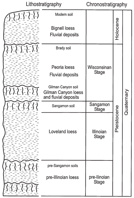
A very good empirical relationship exists between cold stages in the marine oxygen isotope record and documented times of glaciation (ice volume) in the United States (Richmond and Fullerton, 1986b). Given the close correspondence between the glacial record and marine isotope record and the fragmentary nature of the former, it follows that the nearly continuous loessal record should be an excellent terrestrial cognate of the marine isotope record. Therefore, the climatic and chronological record assembled for the marine sequence should match the loessal record well. The generally accepted model relating climate to the loessal record indicates that periods of stability and pedogenesis are usually associated with warm interglacials, and periods of significant loess accumulation coincide with the colder glacial times (Kukla 1977, 1987). Figure 2 provides a summary of the regional stratigraphy.
Figure 2--Lithostratigraphy and chronostratigraphy of study area.
Little is known of the pre-Illinoian loesses because far fewer exposures exist than of the Loveland (Illinoian) loess and certainly the Peoria (late-Wisconsinan) loess. Pedogenesis has been recognized in these early loesses, however. Zones of carbonate enrichment, occurring at about 410-360,330-290, and 250-200 ka, within the Barton County sanitary landfill exposure were interpreted to be pedogenic in origin (Feng et al., 1994). These carbonate zones are likely analogous to the soils observed in the pre-Loveland loesses at the Eustis ash pit, Nebraska (Fredlund et al., 1985) and elsewhere in the region (Schultz and Martin, 1970; Frye and Leonard, 1951). The zones are temporally equivalent to the nonglacial, or warm marine isotope stages (Feng et al., 1994).
No pre-Illinoian Quaternary sediments have yet been recognized on Fort Riley as a result of this series of CERL-funded studies or are reported in the literature. It appears that major entrenchment and denudation preceded the Illinoian because exposures and cores to date have exposed only what is presumed to be Illinoian-age material overlying bedrock. For example, the Illinoian Sangamon soil, loess, and alluvium rest upon a strath, or bedrock-defended terrace at the Sumner Hill locality; conversely, middle Pleistocene loess rests on an erosion surface developed on limestone at the Bala site and sites 27 and 28.
Stratigraphy associated with this stage within the region consists of the Loveland loess and Sangamon soil. The latter is developed within the upper part of the former; as a consequence, they are often outcropping together.
Loveland loess. The Loveland loess is the most widespread pre-Wisconsinan loess in the Midcontinent. Several investigators (e.g., Reed and Dreeszen, 1965; Ruhe, 1969; Willman and Frye, 1970; Ruhe and Olson, 1980) have described it throughout the Missouri, Mississippi and Ohio River basins. Further, it has been recognized south into Mississippi and Arkansas (McCraw and Autin, 1989). The Loveland has been far less studied (e.g., absolute chronology, geometry, mineralogical composition) than the Wisconsinan loesses, namely the Peoria. The Loveland may be described as a yellowish-brown or reddish-brown eolian silt. Red hues increase toward the top of the formation due to development of the Sangamon soil within the uppermost Loveland. The thickest accumulations occur in the north-central part of the state: recorded thicknesses approach 15 m. A thinning in the loess occurs both southward and westward such that the distribution becomes discontinuous to the southwest. In Kansas, the Loveland is typically less than 10 m thick, but produces a very distinctive mark on the landscape via its variation in stratigraphy. It occurs on uplands and valley side slopes. As a result, the Loveland and its capping Sangamon soil are well expressed in exposures, particularly freshly cultivated fields.
The absolute age of Loveland loess in Kansas is largely uncertain, but recent work at sections exposed in a Geary County quarry in northeastern Kansas, the Barton and Pratt County sanitary landfills of central Kansas, and the Eustis ash pit of southwestern Nebraska provided the first absolute-age information on the Loveland beyond that carried out at the paratype section. Oviatt and others (1988) reported TL ages of 136 ka and 130 ka for the upper part of the presumed Loveland loess exposed in an abandoned quarry near the town of Milford, immediately west of Fort Riley. TL age data from this and others sites in Kansas indicates that the Loveland loess began accumulating sometime before 130 ka (Feng et al., 1994; Johnson and Muhs, 1996). Maat and Johnson (1996) derived a TL age of approximately 160 ka immediately below the Sangamon soil in Loveland loess at the Eustis ash pit.
Sangamon soil. This paleosol is strongly developed and occurs throughout the Midcontinent beneath deposits of the Wisconsinan glaciation and within deposits of the Illinoian glaciation or older deposits. The Sangamon soil has been recognized in Indiana (Hall, 1973; Ruhe et al., 1974; Ruhe and Olson, 1980), Illinois (Bushue et al., 1974; Follmer, 1979) where the type section is located (Follmer, 1978), Iowa (Simonson, 1941; Ruhe, 1956, 1969), Nebraska (Schultz and Stout, 1945; Thorpe et al., 1951) and Kansas (Frye and Leonard, 1952). In Kansas, the Sangamon soil is well expressed, occurring throughout the state. Although the soil has received considerable attention in northeastern Kansas (Frye and Leonard, 1949, 1952; Tien, 1968; Caspall, 1970; Bayne et al., 1971; Schaetzl, 1986), it has been recognized at many localities in the state (Bayne and O'Connor, 1968) and recently studied in central Kansas (Feng et al., 1994). Historically, it has been referred to as a "soil in the Sanborn formation" (Hibbard et al., 1944), the Loveland soil (Frye and Pent, 1947), and the Sangamon soil (Frye and Leonard, 1951). The color of the soil ranges from a vivid to pale reddish-brown, with a loss in color occurring westward. Regionally, the soil character varies according to parent material, local drainage and climate which prevailed at the time of pedogenesis. The soil occasionally contains sufficient clay to create a subtle bench on cultivated slopes. Schaetzl (1986) noted that the soil appears to have been a very strongly developed Ultisol or Mollisol.
The Sangamon soil was first used in a time-stratigraphic context to differentiate deposits of the Illinoian and Wisconsinan glacial stages (Leverett, 1899). An appreciable time span for regional landscape stability and soil formation are suggested by oxidation, apparent deep leaching, and high clay accumulation. A major problem associated with the Sangamon soil is its diachronous upper and lower boundaries (Follmer, 1978, 1982, 1983). To further confuse the time element, the lower 1-2 m (3.3-6.6 ft) of the early Wisconsinan loess is typically weathered and forms a pedological continuum with the underlying Sangamon soil (Follmer, 1983), and early investigators mistakenly included the former in the Sangamon profile. The Sangamon should be considered a pedocomplex rather than a single soil which developed under a unique environmental condition (Schultz and Tanner, 1957; Fredlund et al., 1985; Morrison, 1987). It apparently represents two or more paleosols welded together to form a complex that reflects significant spatial and temporal variation in environmental conditions and an appreciable time span. Although laboratory data from exposures in central Kansas indicate the Sangamon soil was strongly weathered chemically, presumably under a warm, moist climate (Feng, 1991), recent data from the Eustis ash pit in south-central Nebraska indicate that the Sangamon soil is not very mature geochemically (Muhs and Johnson, 1996).
Because of apparent time transgressiveness, the age of the Sangamon soil is not precisely known. Follmer (1983) reported a radiocarbon age of 41,700±1100 yr B.P. on plant material from the top of the Sangamon in its type area in Illinois. Forman (1990a) reported TL ages of 140±20 and 70±10 ka from loess below the Sangamon soil at two separate sites in Iowa and Illinois, and concluded the Sangamon soil is diachronous and may consist of multiple soils. Feng (1991) and Feng and others (1994) reported a TL age of about 70 ka in the lowermost part of the Sangamon soil exposed in central Kansas and associate it with marine isotope stage 3. Although Richmond and Fullerton (1986b) assigned Sangamon time to 132-122 ka (isotope substage 5e), they acknowledged reported ages (relative and absolute) ranging from early Illinoian to middle Wisconsin. Basal ages on the overlying Gilman Canyon Formation from numerous locations in Kansas and Nebraska (Johnson, 1993a, b) provide a minimum age of about 45 ka for the Sangamon soil. Also, Forman (1990b) and Forman and others (1992) obtained TL and radiocarbon ages of 35-30 ka within the loess overlying the Sangamon soil at the Loveland paratype section in Iowa and the Pleasant Grove School section in Illinois.
Fort Riley. Thus far, investigations on the reservation have indicated that Illinoian age sediments are ubiquitous but relatively thin, and expressed primarily as the Sangamon soil developed within them. Best known expression of the Sangamon soil occurred at the Sumner Hill locality in a thin layer of Loveland loess overlying alluvium.
Stratigraphy associated with the Wisconsinan glacial period in the central Great Plains consists of two loess units and associated soils: Gilman Canyon Formation and Peoria loess.
Gilman Canyon Formation. The Gilman Canyon Formation, first recognized in Nebraska (Reed and Dreeszen, 1965), is a middle to early-late Wisconsinan (cf. Farmdalian) loess. Equivalents of the formation have been recognized elsewhere: the Loveland loess is buried by the Roxana silt from Minnesota and Wisconsin to Arkansas and by the Pisgah Formation in western Iowa (Bettis, 1990). The Gilman Canyon of Nebraska and Kansas is typically dark in color, silty, leached of calcium carbonate, and heavily enriched in organic carbon via pedogenesis (melanization). As noted above, the formation was once considered to be the attenuated A horizon of the Sangamon soil (Thorpe et al., 1951; Reed and Dreeszen, 1965).
Reed and Dreeszen (1965) provide limited textural data and description of the Gilman Canyon Formation at the type section. Their description within the columnar section at the Buzzard's Roost exposures states (p. 62): "Upper 12 inches [31 cm] is medium dark gray, slightly humic, silt; middle 1 foot 1 inch [33 cm] is light brownish-gray silt; basal 3 feet 8 inches [1.12 m] is dark brownish-gray, humic, soil-like silt; entire thickness is noncalcareous . . . 5 feet 9 inches [1.75 m]." Although all of these attributes described at the type section appear representative of the formation as observed in Nebraska and Kansas, the bimodal distribution of humus is curious: this suggests the existence of two periods of relative stability, or low accumulation rates, and an intervening period of accelerated accumulation rates. Consequently, the Gilman Canyon Formation often appears as one or more cumulic A horizons that are developed within a variably to noncalcareous loess, usually no more than 1.2 m thick. In a section revealing an expanded valley phase of the Gilman Canyon Formation, May and Souders (1988) recognized three distinct organic zones, each of which may represent a separate episode of pedogenesis. Two such zones have been recently observed by the author at the Eustis ash pit in south-central Nebraska. If two or more distinct periods of soil formation did indeed occur regionally, they are obscured at many localities, likely due to bioturbation. Overall, the formation reflects a sufficiently slow rate of loess fall (<0.08mm/yr) such that pedogenesis was operating more or less continuously, but with a decreased intensity at one or more times.
As expressed, the Gilman Canyon Formation is frequently overlain by 0.9-1.5 m of leached loess which is considered to be basal Peoria Formation. Correlative with the Gilman Canyon and overlying leached loess zone is the Citellus zone (a ground squirrel now recognized as the genus Spermophilus) of Nebraska (Condra and Reed, 1950). The leached zone is transitional between the well developed A horizon(s) in the Gilman Canyon and the calcareous Peoria loess above, and probably reflects a sufficiently slow accumulation of Peoria loess such that pedogenesis could keep pace only partially. A.B. Leonard (1951, 1952) supported the contention that the leached, or basal zone was slowly accumulating, early Peoria loess experiencing pedogenesis through inference that gastropods were originally present, but subsequently destroyed during weathering of the loess. Above the leached zone, the rate of accumulation of Peoria loess was sufficiently rapid (c. 0.6mm/yr) as to preclude any soil development.
Radiocarbon ages from the Gilman Canyon Formation range from approximately 40 ka at the base to 20 ka at the top (May and Souders, 1988; Johnson et al., 1993a). The basal age of 40 ka agrees well with the time set by Richmond and Fullerton (1986a) for the beginning of the late Wisconsin. While Nebraska has many dated locations forming an arcuate pattern around the eastern and southern sides of the Sand Hills, data from Kansas are relatively limited. The ages in Kansas do show, however, good agreement from the south-central to the north-central part of the state and with those from Nebraska.
Given the radiocarbon time control and stratigraphic information currently available for the Gilman Canyon Formation within Kansas and Nebraska, it appears that the associated soil is a geosol, i.e. a laterally traceable, mappable, pedostratigraphic unit with a consistent time-stratigraphic position (Morrison, 1965; North American Commission on Stratigraphic Nomenclature, 1983, p. 865). The entire formation may be considered a geosol, but, because of the possibility for the existence of two or more identifiable cumulic A horizons merged or welded together, it may ultimately be considered a composite geosol. On Fort Riley, the Gilman Canyon Formation is typically welded to the Sangamon soil below and to the Brady soil above.
Peoria loess. Leverett (1899) first proposed the name Peoria for an interglacial period between the Iowan and Wisconsin glacial stages. When Alden and Leighton (1917) demonstrated the Peoria was younger than Iowan, usage shifted to that of a loess, rather than a weathering interval. Within the Midcontinent, several names have been used for post-Farmdalian loess. Ruhe (1983) prefers to use the term "late Wisconsin loess" because of the uncertainties in stratigraphic equivalency from one region to another. The Peoria Formation is typically an eolian, calcareous, massive, light yellowish-brown silt that typically overlies the Loveland Formation or an approximate equivalent of the Gilman Canyon Formation.
Ruhe (1983) notes three major features of late-Wisconsinan (Peoria) loess: it thins downwind from the source area, decreases in particle size systematically away from the source area, and is strongly time-transgressive at its base. The latter feature is unresolved and results in correlation problems. Ruhe (1969) realized a decrease in the age of the soil under the loess from 24,500 yr BP near the Missouri River to about 19,000 yr BP eastward across southwestern Iowa. A decrease from 25,000 to 21,000 yr BP was noted for the base of the loess along a transect in Illinois (Kleiss and Fehrenbacher, 1973). The top of the loess also seems to be time-transgressive, ranging from about 12,500 yr BP in Illinois (McKay, 1979b) to 14,000 yr B.P. in central Iowa (Ruhe, 1969).
In Kansas, the Peoria is a reddish, yellowish, or tan buff color, homogeneous, massive, locally fossiliferous, variably calcareous, and ranges from coarse silt and very fine sand to medium to fine silt and clay (Frye and Leonard, 1952). Thicknesses vary from in excess of 30 m adjacent to the Missouri River valley to 0.6 m in discontinuous patches. Any accumulation less than 0.6 m is presumed unrecognizable in the field because it has become incorporated into the existing surface soil. Peoria loess typically rests conformably upon the Gilman Canyon Formation.
Despite the amount of attention given Peoria loess in Kansas, the source of the silt is not completely certain. Upon a review of the available data, Welch and Hale (1987) conclude that a single source was not likely for all loess deposits in Kansas, and that the loess was derived from a combination of three sources: glacial outwash river flood plains, present sand dune areas, and fluvial and eolian erosion of the Ogallala Formation. Research on trace element concentrations in loess (Johnson and Muhs, 1996) indicates, however, that the Platte River valley was the primary source, with secondary inputs from the major river valleys to the south (e.g., Republican, Smoky Hill, Solomon, Arkansas).
Although readily visible stratigraphic breaks such as the Jules soil recognized in Illinois (Frye and Willman, 1973; Frye et al., 1974; Ruhe, 1976; McKay, 1979a, b) and the soil zones in Iowa (Daniels et al., 1960; Ruhe et al., 1971) have not yet been identified in Kansas and adjacent Nebraska, evidence of one or more stable or vegetated surfaces is common. The only indication of soil development recognized is that of a Bt horizon in the Medicine Creek valley (May and Holen, 1993); interestingly, the soil has a probable Paleoindian association (May, 1991). The most common line of evidence for a discontinuity(ies) in Peoria loess deposition is that of plant remains, usually outcropping as lenses. Many of the age determinations were made from Picea remains, indicating a cool, moist environment. Although radiocarbon data document the burial of vegetative material throughout the Woodfordian, two temporal clusters or modes of ages appear from the limited data: one 18-17 ka and another 14-13 ka. The former time interval represents the last glacial maximum and the latter the time of major deglaciation (Ruddiman, 1987). Interpreting ice core data from Greenland, Paterson and Hammer (1987) record a dramatic decrease in atmospheric dust content from about 13,000; this period of reduced atmospheric dust may relate to the time of relative surface stability and tree establishment. Regional geomorphic data also support the existence of a hiatus at this time. May (1989), identifies deposition of the Todd Valley Formation in the South Loup River of central Nebraska at about 14 ka, which is subsequently buried by loess. Further, Martin (1990) identifies entrenchment in the Republican River of south-central Nebraska at about 13 ka, after which valleys were filled with late Peoria Loess.
Fort Riley. The Gilman Canyon Formation sediments and soil were present at all sites sampled for magnetic and isotopic analyses, indicating that the formation has both upland (loess) and valley (alluvium) phases preserved at Fort Riley, as elsewhere in the region. Radiocarbon ages on the formation range from about 19ka to over 23ka. These relatively young ages represent the most recent period of Gilman Canyon time pedogenesis; the relatively unaltered loess and alluvium was not sampled for dating. Coring and backhoe trenching indicates that Peoria loess is typically relatively thin, except along the bluffs of the Kansas River valley, where it reaches thicknesses often or more meters.
The transition from the late Pleistocene into the Holocene, about 10 ka (Hopkins, 1975), was a time of dramatic environmental change and attendant stratigraphic discontinuities. A major feature in the loessal stratigraphic record is a well developed soil, the Brady. Approximately 9,000 years ago, the uplands again destabilized with the renewed influx of loess, which continued episodically throughout the Holocene. Holocene loess is termed the Bignell throughout the central Great Plains.
Brady soil. The Brady soil was first named and described by Schultz and Stout (1948) at the Bignell Hill type locality, an eolian sequence exposed along a road cut in the south valley wall of the Platte River of western Nebraska. The soil is developed within the Peoria loess and is overlain by the Bignell loess. The name was subsequently adopted by researchers in Kansas (Frye and Fent, 1947; Frye and Leonard, 1949, 1951). It is regionally extensive only in the northwestern and west central parts of Kansas, and even there it occurs discontinuously on the landscape. Frye and Leonard (1951) and Caspall (1970, 1972) recognized Brady development in northeastern and other parts of Kansas. Without the overlying Bignell loess, the Brady soil does not exist; the modern surface soil has incorporated post-Bradyan loess fall into its profile or may have developed in Peoria loess subsequent to the erosion of the Brady soil and Bignell loess. The Brady soil is typically dark gray to gray-brown and better developed than the overlying surface soil within the Bignell loess. Strong textural B horizon development and carbonate accumulation in the C horizon are typical, although it occasionally displays evidence of having formed under poorer drainage conditions than have associated surface soils (Frye and Leonard, 1951). Feng (1991) noted that the Brady soil, as expressed in Barton County, is strongly weathered both physically and chemically.
The Brady is the first major geosol to occur in the stratigraphic record of the region since the Gilman Canyon soil 10,000 years earlier. Still, its age had been uncertain, even at the type locality, until recently. Dreeszen (1970, p. 19) reported a radiocarbon age of 9160±250 (W-234) obtained in 1954 and another in 1965 of 9750±300 (W-1676), both from the type section but very likely contaminated by modem plant roots. Subsequently, Lutenegger (1985) reported an age of 8080±180 yr BP but provided no specifics other than that the source was the A horizon of the Brady soil at the type section. Better age control for the type section has since been secured by this investigator: radiocarbon ages of 9,240±110 (Tx-7425) and 10,670±130 (Tx-7358) yr BP were obtained on the upper and lower 5 cm, respectively, of the Brady A horizon.
The Brady soil has been recently dated at localities in Nebraska and Kansas. Souders and Kuzila (1990) obtained a radiocarbon age of 10,130±140 yr BP on the Brady soil occurring within the Republican River valley of south-central Nebraska. Sites along Harlan County Lake upstream from Naponee have yielded a number of ages, ranging from 10,550±160 to 9,020±95 yr BP, on exposures of the Brady soil (Cornwell, 1987; Johnson, 1989; Martin, 1990; Martin and Johnson, 1995). Two radiocarbon ages of 9820±110 (TX-7045) and 10,550±150 (TX-7046) yr BP have been derived from the upper and lower 5 em, respectively, of the Brady A horizon exposed in Barton County, central Kansas (Feng, 1991).
Although it appears Brady pedogenesis occurred from about 10,500 to as recently as 8,500 yr BP, greater refinement of the Brady soil chronology is necessary, but present data clearly indicate it was a product of a major period of landscape stability at a time when widespread climatic shifts were occurring at the end of the Wisconsin. This was the first significant period of soil development since Gilman Canyon time, and represents the climate of the early Holocene. There is an isochronous alluvial soil found throughout the region which is particularly well expressed within the Kansas River basin (Johnson and Martin, 1987; Johnson and Logan, 1990). The two ages of 8,274±500 (C-108a) and 9,880±670 (C-471) yr BP determined from alluvial fill (Fill-2A) at archaeological sites Ft-50 and Ft-41 on Harry Strunk Lake in southwestern Nebraska (Schultz et al., 1951; Libby, 1955) were the first radiocarbon determinations on the Brady soil. The soil, occurring in both eolian and alluvial contexts, appears to qualify, based upon present radiocarbon data, as a geosol, like the Gilman Canyon Formation soil. Collectively, age data indicate a soil forming interval that lasted for 1,500 to 2,000 years.
Development of the Brady soil correlates well with indicators of regional climatic change. The fossil pollen record at Muscotah Marsh of northeastern Kansas indicates that spruce had essentially disappeared from the region by about 10,500 yr BP. As this decline occurred, deciduous tree species increased until about 9,000 years B.P., the time at which grassland expansion began (Grüger, 1973). On a hemispheric scale, the abrupt decrease in atmospheric dust noted in the Greenland ice core at 10,750 yr BP (Paterson and Hammer, 1987) reflects decreased loess deposition and possibly Brady-age pedogenesis associated with relative terrestrial stability. Further, 18O levels within the same core suggest rapid warming about 10,750 yr BP, with the characteristic Holocene temperature regime being established about 9,000 yr BP.
Bignell loess. The Bignell loess was first described and named at the type locality in a bluff exposure on the south side of the Platte River valley southeast of North Platte, Nebraska (Schultz and Stout, 1945). It is typically a gray or yellow-tan, massive silt, calcareous and seldom more than 1.5 m (5 ft) thick. Although it is often somewhat less compact and more friable than the underlying Peoria loess, no certain identification can be made without the presence of the Brady soil. The Bignell loess does not form a continuous mantle on the Peoria; instead, it occurs as discontinuous deposits which are most prevalent and thickest adjacent to modem-day valleys, particularly the south side, and often within depressions on the Peoria surface. Feng (1991) speculates that the Bignell loess of central Kansas is relatively well weathered because it was derived from a preweathered source, the Brady soil surface, perhaps eolian and alluvial phases alike. This is consistent with the earlier interpretation derived in Nebraska that Bignell loess is at least partially comprised of re-worked Peoria loess (Condra et al., 1947, p. 33).
It appears from the radiocarbon ages obtained at the type section in Nebraska and the Speed road cut in northwestern Kansas that the Bignell loess can be no older than 8,000 to 9,000 yr BP Snails collected by A.B. Leonard from the lower part of the Bignell in Doniphan County, northeastern Kansas, produced ages of 12,500±400 (W-231) and 12,700±300 (W-233) yr BP (Frye and Leonard, 1965). Because the shell material had absorbed an indeterminate amount of dead carbonate, Frye and others (1968) proposed an averaged age of approximately 11,000 years. Based upon the age data available for the Brady, the soil humate-derived ages are probably closest to reality.
Fort Riley. The Brady soil and Bignell loess are prominent elements of the late-Quaternary stratigraphy on the reservation. Together with the surface soil, they typically comprise the approximately upper 2 m of most sites documented (D.L. Johnson, 1996), including the loess sites references in this report. Therefore, it appears that appreciable loess was deposited during the Holocene. This is not surprising given the proximal juncture of two large stream systems, which formed a significant loess source (dust from a relatively wide valley floor), and the situation of the sites on the north side of the river valley with prevailing southerly winds.
Late-Quaternary alluvium is ubiquitous throughout the installation and is the primary focus of the Fort Riley geoarchaeological investigations due to the concentration of surficial and buried cultural material. Alluvial deposits recognized thus far on the installation date to the last glacial period (Fig. 2).
Much of the chronology of late-Wisconsinan landform evolution for the region was compiled in the 1940s and early 1950s, prior to the use of radiocarbon dating (e.g., Lugn, 1935; Schultz and Stout, 1945; Frye and Leonard, 1951), and focused to a large degree on the upland rather than valley deposits. Additionally, erosion has removed a large part of late-Quaternary record from most drainage basins in the central Great Plains (Knox, 1983). Accordingly, a comprehensive sedimentation and erosion chronology for the region during the late Wisconsin is lacking.
It is becoming increasingly apparent that entrenchment occurred in the channels of the Kansas River basin sometime during the late Wisconsin. A basal soil buried within the fill of both tributary and major stream valleys of the Kansas River basin has an age of 10,500-10,000 yr BP (Johnson and Martin, 1987; Johnson and Logan, 1990), thereby providing a minimum age on the entrenchment. May (1989) has radiocarbon dated the Todd valley fluvial sand of central Nebraska to about 14,000 years B.P., although Condra et al. (1950) had postulated a much earlier Wisconsinan age. Martin (1990; 1993) recognized a late-Wisconsin fill in the Republican River valley that was largely removed through entrenchment about 13,000 yr BP. A radiocarbon age of 14,700 yr BP was obtained on spruce wood situated above cross bedded fluvial sand and gravel at the North Cove site located in that same reach of the Republican River valley (Wells and Stewart, 1987; Johnson, 1989). At the Prairie Dog Bay site in the Republican River valley, the stratigraphy and radiocarbon ages suggest down cutting before 11,800 yr BP (Martin, 1990, 1993). Speculation about the cause of this entrenchment centers on an increase in effective moisture as climatic conditions ameliorated towards the end of the Pleistocene. Spring deposits dating to this time at the North Cove site possibly formed during the increase in moisture (Johnson, 1989; Martin, 1990).
Brice (1964) studied alluvial fills and terraces in the valleys of the North Loup, Middle Loup, and South Loup rivers of central Nebraska, and identified two major terraces in the Loup valleys. The Kilgore terrace occurs as remnants 26 to 30m above stream level along the South Loup River. Brice suggested that valley fill underlying the Kilgore terrace is Peorian (late Wisconsin) in age. The adjacent Elba Terrace, which stands 11 to 12 m above stream level, is the most prominent and extensive terrace in the main valleys and is primarily of Holocene age.
During the last decade, a great deal of attention has been focused on the development of alluvial chronologies in the central Great Plains, typically in connection with geoarchaeological investigations. As a consequence, this research has resulted in a number of studies and a sizable radiocarbon data base; well over 400 radiocarbon ages have been obtained from alluvium in Kansas and Nebraska (Johnson et al., 1996). Only a sampling of the many studies is presented below.
Much of the research in Nebraska has focused on the Loup River basin. Brice (1964) recognized two major terrace systems in the basin and obtained early Holocene radiocarbon ages of 10,500, 9,000, and 8,500 yr BP on fill beneath the lower of these terraces, the Elba. In a recent re-examination of the Elba terrace, May (1990, 1991) secured radiocarbon ages ranging from nearly 11,000 to 4,670 yr BP from the Cooper's Canyon area. On the South Loup River, May (1986, 1989, 1992) recognized four alluvial fills, with the oldest one dating between about 10,200 and 4,700 years B.P., thereby correlating temporally with the Elba terrace of the North Loup. Elsewhere in the basin, Ahlbrandt and others (1983) dated organic accumulations in alluvial sands at 8,410 yr BP from a site on the Dismal River.
In the Kansas River basin, alluvial geomorphic studies have a relatively long history, beginning in the 1950s. The first dating of alluvial stratigraphy on the Kansas River proper was done by Holien (1982), who obtained an age of 10,450 yr BP on a soil buried within lower Newman terrace fill at the Bonner Spring site. Subsequent radiocarbon dating of Newman fill at this locality (Johnson and Martin, 1987; Johnson and Logan, 1990) and others (Bowman, 1985) produced more early Holocene ages. The lower Holliday terrace has dated about 4,300 yr BP and younger (Johnson and Logan, 1990).
Many studies have been conducted elsewhere in the Kansas River basin on the many tributaries. Some of the first radiocarbon dating was carried out on samples collected from the Republican River basin by Schultz and others (1948): from varied locations they secured early to middle Holocene ages from buried soils. The most recent research in the basin was conducted by Martin (1990, 1992) who concluded from dating various alluvial fills that the majority of the fill was deposited less than about 4,600 yr BP.
Several geoarchaeological studies were done in conjunction with cultural resource management projects focusing on federal impoundments within the Kansas River basin. Mandel (1987) in a study of the lower Wakarusa River recognized two terraces, the lower of which produced radiocarbon ages of about 2,900 yr BP and less. A study of the alluvial history of the Smoky Hill River in the vicinity of Kanopolis Lake (Mandel, 1988, 1992) revealed a striking absence of early and middle Holocene fill in small valleys, and middle Holocene fill in the main valleys and in alluvial fans.
In their study of Wolf Creek basin, Kansas, Arbogast and Johnson (1994) observed that alluviation of early-Holocene flood plains in this small basin was episodic, with at least one period of flood plain stability and soil formation about 6,800 yr BP. During the middle Holocene (ca. 6,500-5,300 yr BP), lateral erosion and entrenchment flushed most early-Holocene fill from the main valley ofWolf Creek and the lower reaches of its larger tributaries. Fallowing the interval of mid-Holocene erosion, sediment accumulated on flood plains between 5,300 and 3,000 yr BP. Late Holocene alluviation was episodic, with intervening periods of flood plain stability and soil formation about 1,800, 1,500, and 1,200 yr BP.
A number of studies have been conducted in the Arkansas River basin area of south-central and southeastern Kansas. Mandel examined terraces and associated fills in the Neosho (Mandel, 1989, 1992, 1993) and Verdigris Rivers (Mandel, 1993), obtaining radiocarbon ages on fill to about 4,200 yr BP. The most extensive study in the Arkansas River basin was that of the Pawnee River basin by Mandel (1988, 1991, 1994). Two terraces were recognized in the higher order tributaries, with fill of the high terrace dating between about 10,000 and 5,000 yr BP, and that of the low terrace to 3,000 yr BP and younger. Of the three terraces present in the lower part of the system, the lowermost one has Holocene fill and the others are Pleistocene. Holocene valley fills in the Pawnee Basin appear to lack soil development from about 7,000 to 5,000 yr BP.
The alluvial record is temporally and spatially fragmented, i.e., the history of valley and stream evolution stored in alluvium is scattered and wrought with gaps. So, it is only by assembling this fragmentary information that one obtains a unified perspective on the record of stream evolution. Out of the many studies conducted in recent years, a pattern of change is emerging. Large stream valleys appear to contain, more or less, alluvial fill dating throughout the Holocene, whereas small stream valleys typically contain only fill dating in the late Holocene. This model has an intuitive basis in that the probability of survival of early and middle Holocene fill in smaller streams is greatly diminished by the limited storage capacity for alluvium and the relatively high stream gradients, large area in hillslope, and associated peaked flood waves. Exceptions to this pattern do, of course, exist (e.g., Lime Creek, Nebraska: May, 1996; Wolf Creek: Arbogast and Johnson, 1994), but are likely due to locally unusual valley width and other discernible factors.
A first approximation of this alluvial model was presented by Johnson and Martin (1987) in an examination of radiocarbon ages obtained from alluvial fill in the central Great Plains. In recent years, the model has evolved with a vastly expanded data base and been articulated recently by Mandel (1995). He noted that fill in small valleys appears to be less than 4,000 years old, and that the missing early and middle-Holocene record is frequently preserved at the lower end of small stream valleys as terrace fill or alluvial fans.
From the alluvial chronologies, it is obvious that regional synchroneity of stream behavior exists in the central Great Plains (Johnson and Martin, 1987; Johnson and Logan, 1990; Mandel, 1995). When erosion and sedimentation are considered in a stream hierarchical sense, patterns of coincidence appear, such as similar times of flood-plain stability and attendant soil formation. A frequency distribution of over 400 radiocarbon ages from alluvium of Kansas and Nebraska) provides an indication of the synchroneity. The high frequencies of the last 5,000 years reflect the age of the alluvium in large and small streams, whereas those prior to about 8,000 represent the ages from the large valleys alone. Alluvial fans ages account for many ages within the 4,000 to 8,000 year range (Mandel, 1995). The greatest frequency of ages occurs about 1,200 yr BP, a time when pronounced low terrace stability and soil development occurred throughout the stream systems. Another notable feature of the distribution is that when the ages obtained from alluvial fans are not considered, very few alluvial ages fall within the 5,000 to 7000 yr BP period. This paucity of ages suggests little flood-plain stability and/or preservation of alluvium from that interval, which coincides with the Altithermal climatic episode. Stream activity of this dry period may have been characterized by rapid sedimentation, thereby precluding soil development, in response to low-frequency, high-intensity convectional storms (Knox, 1976, 1983).
Regional synchrony in Holocene fluvial behavior suggests that climatic fluctuation is the dominant external variable in stream systems (Wendland, 1982; Knox, 1976, 1983). Changes in climate during the Holocene were frequent and episodic (e.g., Wendland and Bryson, 1974; Kutzbach, 1985; COHMAP members, 1988), resulting in discrete periods of stream stability and instability (Knox, 1983).
The concept of a middle Holocene, or Altithermal (ca. 7,000-5,000 yr BP) cultural hiatus on the Great Plains has become well-entrenched within the archaeological literatures. Of the various theories put forth to explain the hiatus (Reeves, 1973), fluvial erosion or aggradation sufficient to dramatically alter the record for the region during the interval 7,000-5,000 yr BP is most pertinent (Johnson, 1987; Mandel, 1995). Some argued that the similarity in the alluvial stratigraphic record from eastern humid portions of the region to the more arid western areas, as well as with chronologies further afield indicates that regionally anomalous erosion and deposition do not explain the hiatus completely; rather, the increased dryness during the Altithermal was likely sufficient to reduce populations on the Plains (Wedel, 1961; Knox, 1978; Wendland, 1978). However, the rapidly expanding alluvial radiocarbon and stratigraphic data base for the region is indicating that much of the cultural record, namely that of the Archaic period, is buried, often deeply, or lost to erosion.
As the most recent glacial episode, the Wisconsin has the greatest chronostratigraphic resolution. However, existing knowledge of the climatic environment for this time interval is relatively limited and inconsistent for the central Great Plains. To date, either pollen records from peripheral areas or synthesis of various types of proxy data have been used to reconstruct climate history of the region.
The insolation record exhibits two relatively warm peaks (c. 50 and 30 ka) during marine isotope stage 3. Each peak is followed by a relatively minor and gradual decrease, culminating in the decrease to the glacial maximum (c. 18ka). In contrast to the gradual insolation changes, most paleoclimatic records from this interval indicate rapid alternations of warm and cold events, which in frequency and timing appear to be unrelated to the Milankovitch forcing (Curry and Follmer, 1992). Dansgaard and others (1985) showed that rapid and extreme fluctuations in stable isotopes (signifying air-temperature differences of 5° C) from two sites in Greenland appear to correlate over the past 50,000 years . These fluctuations are in phase with changes in CO2 and dust content. Rapid and substantial temperature fluctuations recorded in ice core segments during stage 3 also correspond with oscillations in the North Atlantic marine sediment record of species abundance and ice rafting (Heinrich, 1988). Using accelerator 14C ages on a planktonic polar species, Broecker and others (1988) identified four rapid climatic oscillation between 40 and 22 ka in the North Atlantic.
The regional upland vegetation, as inferred from the pollen record from Cheyenne Bottom in Kansas (Fredlund, 1995), appears to have been nearly treeless throughout the Farmdalian (ca. 30-24 ka). The pollen record suggests that, although regional tree and shrub populations were higher and more diverse than in Holocene, they were a secondary component of the overall vegetative structure. Grassland-sage steppe dominated the regional uplands surrounding the Cheyenne Bottoms basin throughout the Farmdalian period. The rise in Cheno-Am pollen percentages and an influx of sand beginning at about 25 ka probably mark the rapid onset of a cycle of aridity. Immediately after the onset of aridity, the most noticeable changes are declining percentages in the Cheno-Am types and rising percentages of Pinus. The increase in Picea and other arboreal pollen may signal a climatic shift toward cooler climatic conditions at ca. 24 ka. Unfortunately, the Woodfordian substage of the Wisconsin is missing from the Cheyenne Bottoms record.
Limiting radiocarbon dates in North America indicate that glaciation commenced about 25-27 ka and thus allow less than 10,000 years for ice buildup prior to 18 ka (Andrews, 1987). The structure of deglaciation is uncertain. There is evidence supporting: (1) a smooth deglaciation model with fastest ice wastage centered on 11 ka; (2) a two-step deglaciation model with rapid ice wasting from 14 to 12 ka and 10 to 7 ka, and a mid-deglacial pause with little or no ice disintegration from 12 to 10 ka; and (3) a Younger Dryas deglaciation model with two rapid deglacial steps as in (2) above, interrupted by a mid-deglacial reversal with significant ice growth from 11 to 10 ka.
The data supporting the smooth deglaciation model are maps of Laurentide ice area based on radiocarbon-dated glacial deposits (Andrews, 1987). Although there are subtle suggestions of more rapid retreat at or near the time of the two steps mentioned above, these curves indicate a steady progressive retreat of North America ice, with significant oscillations in retreat rate only at local spatial scales. Some marine δ18O curves also show a smooth progressive decrease toward Holocene values.
The step deglaciation model is also supported by some marine δ18O records (Mix, 1987). In addition, the distinctive patterns of change in sea-surface temperature of the North Atlantic Ocean and in Greenland ice-core δ18O values also show abrupt step-like warmings at 10 ka and about 13 ka; these warmings might be associated with step-like decreases in Laurentide ice volume. Regionally integrated rates of pollen change in eastern and central North America also show a rapid change in centered on 13.7 and 12.3 ka. (Ruddimann, 1987).
The Younger Dryas (e.g., Osborn et al., 1995: Bard et al., 1993; Peteet et al., 1992) deglaciation model is suggested by the strong signal of sea-surface temperature cooling between 11 and 10 ka in the North Atlantic Ocean. At least early and perhaps all of Brady pedogenesis coincides with an abrupt and brief cool interval correlative with the classic Younger Dryas cold interval of the North Atlantic region.
By the middle Holocene, drying had reached a maximum according to most studies. Northwest Texas was experiencing conditions of maximum temperatures, minimum precipitation, and eolian activity between 6000 and 4500 years B.P. (Holliday et al., 1983; Holliday, 1985; 1989; Johnson, 1987; Pierce, 1987). This episode coincides with δ13C values from soil organic matter from the same area revealing a shift from -23‰ in the early Holocene to -15‰ in the middle Holocene (Haas et al., 1986). These results were interpreted to represent a shift from cool-season C3 grasses to warm-season C4 grasses. Based on enriched δ13C values in soil carbonate from northwest Texas, Humphrey and Ferring (1994) also show a middle Holocene xeric episode, although the δ18O values from these same carbonates do not indicate a significant temperature change.
A noticeable shift back to cooler and/or wetter conditions was detected in many areas shortly after 5000 yr BP. The Great Bend Sand Prairie transformed to conditions much like present (Arbogast, 1995). According to Humphrey and Ferring (1994), the return to mesic conditions after 5000 yr BP was interrupted in north-central Texas by a brief warming and drying episode between 2000 and 1000 yr BP. Based on depositional environments, they concluded that cooler and wetter conditions returned after 1000 yr BP.
Next page--Methods
Kansas Geological Survey
Placed online March 7, 2012; originally released June 2000
Comments to webadmin@kgs.ku.edu
The URL for this page is http://www.kgs.ku.edu/Hydro/Publications/2000/OFR00_65/index.html