Kansas Geological Survey, Open-file Report 1999-36
by
Robert Sawin, Jim McCauley, Rex Buchanan, and Wayne Lebsack
KGS Open-file Report 1999-36
Kansas Geological Survey staff members, accompanied by Wayne Lebsack of The Nature Conservancy, conducted a geologic reconnaissance of the Conservancy's Smoky Valley Ranch Preserve in Logan County, Kansas, on August 9-12, 1999. The purpose of the reconnaissance was to investigate known geologic features and evaluate the geologic and paleontologic opportunities at the preserve.
The Survey is interested in helping the Conservancy develop geologic information about the Smoky Valley Ranch Preserve. Projects of this kind are part of the Survey's public outreach effort (Geology Extension program) to develop materials that communicate information about the geology of Kansas to the people of the state. The Survey can help the Conservancy understand the basic geology at the preserve and develop geologic information for articles, brochures, and field trips, and assist with interpretative materials such as kiosks, trail guides, and field guides of the area.
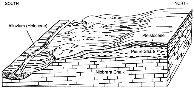
The oldest rocks exposed at the Smoky Valley Ranch Preserve belong to the Smoky Hill Chalk member of the Niobrara Chalk formation (see Figure 1). These rocks were deposited during the Cretaceous Period, about 80 million years ago, and form the numerous chalk badlands that occur at the preserve. Rocks in the Pierre Shale formation, also Cretaceous in age, overlie the Niobrara but crop out only in the northern part of the preserve. The uplands are mantled by sand and gravel and wind-blown silt (loess) deposited during the Pleistocene Epoch, which started about 1.8 million years ago. The youngest rocks on the preserve are sand dunes in the uplands and alluvium in the Smoky Hill River valley (see Figure 2) that were deposited during the last ten thousand years, known as the Holocene, or Recent Epoch.
Figure 1. Graphic column of rocks exposed at the Smoky Valley Ranch Preserve.
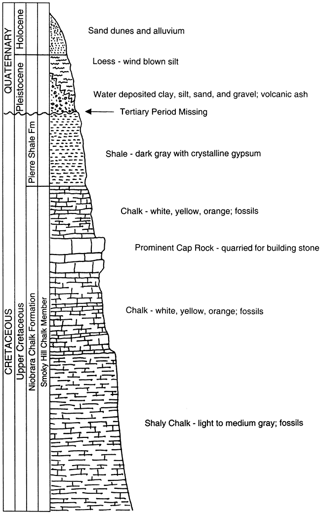
Late in Cretaceous times, about 80 million years ago, the western United States, including Kansas, was covered by a vast inland sea that was several hundred feet deep. Hundreds of feet of shale, limestone, and chalk (a form of limestone) were deposited on the floor of this sea. Thin beds of bentonite in these rocks are probably the result of volcanic ash that was blown into the air, fell into the Cretaceous sea, and was altered over time to form layers of bentonite (Johnson, 1958).
Figure 2. Generalized diagram showing the layered sequence of rocks at the Smoky Valley Ranch Preserve. The uplands are represented at the north end of the preserve and the Smoky Hill River valley is at the south (adapted from Bell, et al., 1964).
At the end of the Cretaceous period, about 65 million years ago, the Rocky Mountains began to form and the sea that had covered Kansas withdrew. Since that time, western Kansas has remained above sea level. During the Tertiary Period, conditions favored rapid erosion of the mountains to the west, and large quantities of gravel, sand, silt, and clay were carried by streams flowing eastward from the mountains across the broad plains and wide, shallow valleys. Lens-shaped and sheetlike beds of these deposits, called the Ogallala Formation, not only filled the shallow valleys, but also spread across the divides, so by the end of the Tertiary (beginning of the Pleistocene), about 1.8 million years ago, westem Kansas was covered with a veneer of sediments (Johnson, 1958).
During the Pleistocene, streams cut valleys into the Tertiary and Cretaceous rocks. Today the Ogallala Formation has been entirely eroded away along the Smoky Hill River valley, and is not present at the preserve, leaving a gap of over 60 million years in the geologic record (from the end of the Cretaceous to the beginning of the Pleistocene). Early Pleistocene deposits consisting of silt, sandy clay, and coarse gravel and sand were deposited on the flanks of larger streams, which occupied valleys about in their present geographical positions, but at higher elevations. These deposits were left above the present floodplain by a deepening of the channel into the Cretaceous rocks. Late in Pleistocene time, a thick mantle of silt (loess) was deposited over the area, chiefly by the wind (Johnson, 1958).
The beginning of the Holocene (Recent) period (about 10,000 years ago to present) was a time of dramatic climatic and environmental changes associated with the melting of the ice sheets. Alluvial deposits along present day major streams and some of their tributaries, and sand dunes in the uplands, are Holocene in age.
Niobrara Chalk. The Smoky Hill Chalk member of the Niobrara Chalk formation is the oldest rock exposed at the preserve. Along the Smoky Hill River and its tributaries, large areas of Smoky Hill Chalk are exposed as "chalk badlands."
The Smoky Hill Chalk consists of chalk and shaly chalk that weathers to white, yellow, pink, and orange in the upper part, and a light- to medium-gray (some call it blue-gray) color below. The upper part becomes harder and more blocky as it weathers, forming the cap rock that tops pinnacles and cliffs in many areas of the badlands. The lower part of the Smoky Hill Chalk is shalier, causing weathered surfaces to appear thin-bedded.
Thin bentonite beds are common and can be traced many miles along the outcrop. Pyrite concretions are present throughout the member but are more common in some zones. Large, soft, reddish- to yellowish-brown concretions of limonite (an iron-based mineral) and pyrite are arranged in indistinct disconnected layers in the upper and middle parts of the member (Johnson, 1958). Thin layers of gypsum also occur in the Niobrara. The Pierre Shale overlies the Niobrara, from which it can be distinguished from the lighter colored chalk by its dark-gray color, and noncalcareous (lacking calcium carbonate), fissile (thin-bedded, flaky) nature.
Pierre Shale. The Pierre Shale is a dark-gray, fissile, noncalcareous shale that occurs in thick beds interspersed with seams of bentonite, limonite, and crystalline gypsum. The shale contains many different types of concretions. The Pierre Shale is overlain by Pleistocene deposits. The only outcrops of Pierre Shale are on the north end of the preserve.
Pleistocene deposits. Pleistocene deposits consist mainly of clay, sandy silt, fine sand, sand and gravel, volcanic ash, and loess (wind-blown silt). These deposits are usually unconsolidated (except for a coarse, cross-bedded sand and gravel that sometimes occurs at the base) and mantle the uplands at the preserve.
Holocene (Recent) deposits. The Holocene is represented by sand dunes in the uplands, and alluvial deposits of clay, silt, sand, and gravel deposited over the floodplain or in the channels of active streams. The floodplain of the Smoky Hill River and some of its tributaries contain alluvium. Dune sand is present in the uplands where the wind has stripped the loess cover and exposed the sandy layers.
Several interesting geologic features occur on the preserve. The numbers below correspond to the numbered locations on Figure 3.
Figure 3. Geologic points of interest at the Smoky Valley Ranch Preserve. Chalk Badlands (1), Chalk Quarries (2), Fossils (3), Bison Kill Site (4), Gypsum (5), Faults (6), Volcanic Ash (7), Cross-bedded Sand and Gravel Deposits (8).
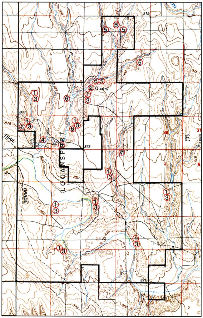
Chalk Badlands (1). The Smoky Hill Chalk member crops out at several localities on the preserve. The largest areas are found along the Smoky Hill River, but the three main north-south tributaries that cross the preserve north of the river also contain some excellent chalk exposures. These badlands offer scenic views of steep bluffs, steep-walled canyons, and pinnacles cut from the soft chalk by the action of water. Many of the chalk exposures cover tens of acres.
Chalk is a soft, porous, very fine-grained limestone that forms from the sea-floor accumulation of tiny marine organisms that lived near the ocean's surface. As the tiny shells piled up, a soft limy ooze formed on the sea floor, perfect for engulfing and preserving the remains of other animals--such as fish, sharks, turtles, clams, and marine reptiles--that fell to the bottom of the sea.
Chalk Quarries (2). The upper part of the Smoky Hill Chalk member was quarried for building stone at several locations about three miles north of the preserve's ranch house. Saw marks, cut blocks, and other remnants of the quarry operation can be seen at three different sites in this area. The cap rock, a harder, more resistant layer near the top of the Smoky Hill Chalk, was the stone of choice for building. When first uncovered, the stone is soft enough to cut with a saw; after it is exposed to the air, it becomes harder. Examples of structures built from the chalk are the ranch headquarters and the abandoned house hear Blue Knob, about a mile southwest of the headquarters.
Fossils (3). The Smoky Hill Chalk member has become famous for the important skeletal remains of fish, sharks, marine reptiles, turtles, and birds that have been found in the chalk (Hattin, 1982). More common are the invertebrate clams (Inoceramus) and oysters (Ostrea), ammonites, sharks teeth, and other fish remains (vertebrae, bones, and scales) found at almost all chalk exposures at the preserve. The crinoid, Uintacrinus, an ancient relative of the starfish, has been collected from at least two localities on the preserve, however, this fossil occurs in thin layers and weathers easily, so finds are rare. Well-preserved skeletons of large fish, swimming reptiles (mosasaurs, plesiosaurs), turtles, birds, and flying reptiles (pterosaurs), while extremely rare, are found in the Cretaceous rocks in this part of western Kansas and could potentially be found at the preserve.
Bison Kill Site (4). About one-half mile north of where 12 Mile Creek empties into the Smoky Hill River is a late 19th century archaeological site, known as the 12 Mile Creek Site. Here, early hunters drove bison over the edge of a ravine (Williston, 1902). In 1895, fossil bones of several extinct bison species were found associated with a Clovis projectile point. Radiocarbon testing dated the bison bones at about 10,300 years before present, making them Pleistocene in age. Pollen analysis of the site suggests that the vegetation at the time of the bison kill consisted of open areas of grass interspersed with stands of pine trees and also that the climate was cooler (Rogers and Martin, 1984).
Gypsum (5). Exposures of the dark-gray Pierre Shale are heavily littered with a variety of crystalline gypsum called selenite. The chemical composition of the mineral gypsum is calcium sulfate with two molecules of water (CaSO4 + 2H2O). Gypsum causes much of the ground water in this area to be high in sulfates, which gives drinking water a laxative effect.
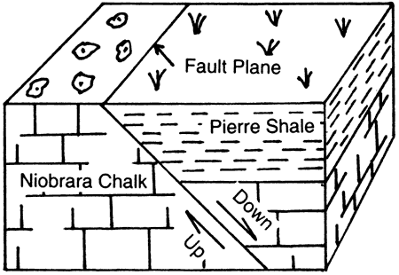
Faults (6). The most common tectonic features observed at the preserve are small faults in the Cretaceous rocks. Four faults are visible on the surface at the preserve, marked by a change in the color of the soil or bedrock, or a change in vegetation. Sometimes the fault plane is distinguished by striated calcite filling. The faults are normal (tensional) and dip about 45 degrees (Figure 4). The exact displacement is not known. Gentle folding and steeply dipping beds are often associated with the faults. Random orientation of the faults in this area suggests they are not related to a major structural trend, but are probably a result of local changes of the underlying sediments.
Figure 4. Diagram of a typical fault.
Volcanic Ash (7). Exposures of volcanic ash deposits up to 5.5 feet thick have been reported by Johnson (1958) and Carey et al. (1952) at the preserve. The ash is associated with Pleistocene deposits and is light gray to white and friable.
Cross-bedded Sand and Gravel Deposits (8). Deposits of cross-bedded sand and gravel (Pleistocene) are found at scattered locations at the preserve. These deposits are directly in contact with the Smoky Hill Chalk member, probably filling erosional valleys. The cross-bedding indicates that these are fluvial deposits, that is, produced by the action of a stream or river. The best place to see these rocks is in the bank of Twelve Mile Creek, about one-half mile east of the Bison Kill Site.
Bell, E. L., Call, C. M., Hagihara, J. S., and Linnell, L. D., 1964, Soil survey of Logan County, Kansas: U.S. Department of Agriculture in Cooperation with the Kansas Agricultural Experiment Station, 78 p.
Carey, J. S., Frye, J. C., Plummer, N., and Swineford, A., 1952, Kansas volcanic ash resources: Kansas Geological Survey, Bulletin 96, part 1, 68 p. [available online]
Hattin, D. E., 1982, Stratigraphy and depositional environment of Smoky Hill Chalk Member, Niobrara Chalk (Upper Cretaceous) of the type area, Western Kansas: Kansas Geological Survey, Bulletin 225, 108 p. [available online]
Johnson, C. R., 1958, Geology and groundwater resources of Logan County, Kansas: Kansas Geological Survey, Bulletin 129, 178 p. [available online]
Rogers, R. A., and Martin, L. D., 1984, The 12 Mile Creek site--A reinvestigation: American Antiquity, v. 49, no. 4, p. 757-764.
Williston, S. W., 1902, An arrow-head found with bones of Bison occidentalis Lucas, in western Kansas: American Geologist, v. 30,p. 313-315.
Kansas Geological Survey, Public Outreach
Placed online Nov. 26, 2007
Comments to webadmin@kgs.ku.edu
The URL for this page is http://www.kgs.ku.edu/Publications/OFR/1999/OFR99_36/index.html