Kansas Geological Survey, Open-file Rept. 94-23, page 3 of 4
Prev--Descriptions of sections ||
Next--References
The lowest cycle of the Roca Shale is capped by laminated mudstone with welldeveloped desiccation cracked surfaces. Desiccation-like features at the top of the second cycle appear to be columnar peds in a poorly-developed paleosol horizon. Such domed soil structures are usually attributed to the accumulation of sodium, and suggest a dry environment with high evapo-transporation rates.
The next two cycles have paleosols with well-developed color horizonation, angular to subangular blocky ped structure, and carbonate nodules and rhizocretions. These paleosols would be classified as Calcic Argillisols or Calcisols by Mack and others (1993). The lower paleosol contains abundant fine dendritic drab root traces in a reddish-brown very silty matrix. This silt may have had its origin as wind-blown loess from the extensive eolian dunefields to the west (see Johnson, 1989; Soreghan, 1992). The upper calcic paleosol has well-developed clay cutans around the angular blocky peds indicating considerable clay illuviation under relatively humid conditions. However, the accumulation of calcium carbonate in rhizocretions and nodules higher in both profiles indicate subhumid to semiarid conditions with low rainfall or high evapo-transpiration rates late in paleosol development (McCahon and Miller 1993). The grayish red to reddish brown horizons suggest well-drained soils that remained above the water table (Retallack, 1990).
The upper paleosol profile of the Roca is a Vertisol or Calcic Vertisol (Mack et al., 1993) and has very well-developed pseudoanticlines (mukkara structure) with pedogenic slickensides. The hummocky surface relief of these pedogenic structures is easily observed on the extensive eroded surfaces of the spillway. Pseudoanticlines are produced by the shrinkage and expansion of clay-rich soils associated with highly seasonal wet/dry climates (Kraus and Aslan, 1993; Driese et al., 1992). The uniform greenish gray to yellowish gray color of the profile suggests saturation of soil during part of the year. The absence of clearly-developed horizonation is also consistent with extensive turbation associated with seasonal wetting and drying (Birkeland, 1984). The abundant carbonate nodules in the upper part of the profile suggest a trend toward drier conditions during later phases of paleosol development.
The uppermost exposure surface within this cyclothem occurs within the Legion Shale Member. Deep desiccation cracks up to 50 cm or more deep are filled with micritic carbonate. Above these deep cracks is a thin columnar ped horizon containing clay-filled root traces. This columnar structure again indicates the acumulation of salts in the developing soil and suggests a relatively dry environment.
Two climatic patterns are recognized from the examination of paleosol profiles within this cyclothem-scale sedimentary cycle. FIRST, cyclothem-scale sealevel changes appear to be associated with significant climate change in the midcontinent. There is a general climate trend within the Roca Shale from semi-arid conditions recorded by the columnar horizon and calcic paleosols, to a seasonal wet/dry climate at the top recorded by the vertic paleosol. This trend is reversed with the return of saline conditions in the Legion Member paleosol, and continues into the overlying Burr Limestone Member as evidenced by the presence of large gypsum crystal molds. The inferred climatic pattern from semi-arid to seasonal wet/ dry conditions has also been recognized within the variegated mudstone intervals of most Council Grove Group and lower Chase Group cyclothems (Fig. 4). SECOND, there is evidence for climate change associated with meter-scale cycles. Environmental conditions appear to have become drier during the development of individual paleosol profiles. This is most clearly displayed in the Calcic Argillisols where carbonate precipitation followed a period of significant clay illuviation (Fig. 5).
Figure 4. Patterns of paleosol development. Stacked paleosols within cyclothems of the lower Permian in northeastern Kansas show a consistent pattern of development. The four cyclothems illustrated above, from the Council Grove and lower Chase Groups near Manhattan in Riley County, each show the same trend from calcic to vertic paleosols suggesting a repeated pattern of climate change associated with cyclothem deposition. Sections show cyclothems bounded by transgressive surfaces (T), and meter-scale cycles (parasequences) bounded by flooding surfaces (arrows).
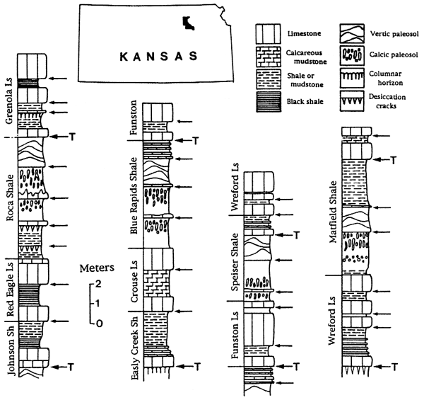
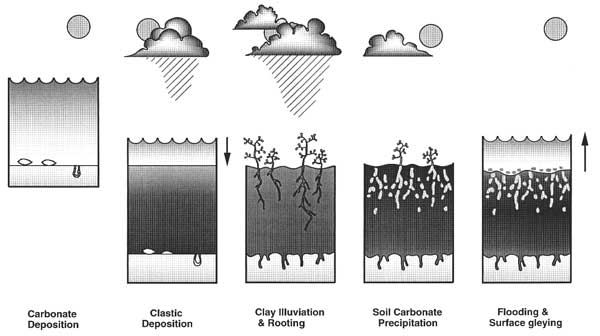
Figure 5. Illustrated model of paleosol formation. Interaction of sealevel change and climate change on the formation of paleosols as interpreted by the cycle model of Miller and West (1993). Arid to semi-arid conditions prevailed during sealevel rise and highstand. Seasonally wet climates were associated with falling sealevel and deposition of siliciclastic muds. Pedogenesis followed first under humid conditions resulting in illuviated clays, and subsequently under semi-arid conditions producing carbonate nodules and rhizocretions. Flooding of the soil resulted in surface gleying and the formation of an intraclastic lag.
The consistent carbonate to siliciclastic pattern of meter-scale cycles, within both the open marine facies and paleosol-bearing intervals of cyclothems, indicates that glacio-eustatic seaelvel change alone in not adequate to explain the observed cyclicity. A model for climatic control over facies development proposed by Cecil (1990) provides a basis for developing a more complete model of cyclothem formation. In this model, clastic sediment transport is predicted to be highest in seasonal wet-dry climates and lower in both and and tropical wet climates (see also Wilson, 1973; Perlmutter and Matthews, 1989). Carbonates and evaporites accumulate during and and semiarid conditions, and mappable coal beds form during relatively wet climates when clastic influx is low. Because carbonates typically overlie the flooding surfaces of meter-scale cycles, acceptance of Cecil's model would indicate that drier conditions were associated with sealevel rise (interglacials) and wetter climates associated with sealevel fall (glacials).
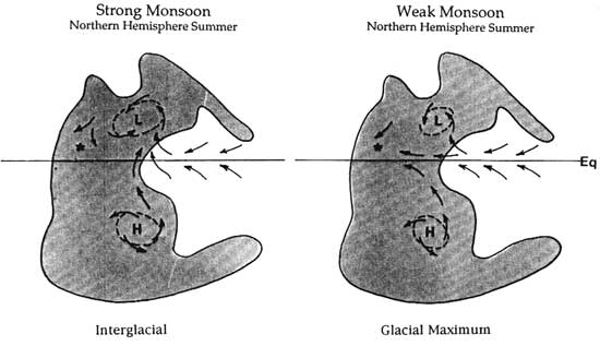
Miller and West (1993) recently proposed a cycle model assuming that the climate of the mid-continent was strongly affected by a Pangean monsoon, and that fluctuations in the intensity of the monsoon produced oscillations between wetter and drier conditions (Fig. 6). During interglacial periods when the monsoon was strong, the wet equatorial air would have been diverted to the north or south, resulting in a dry midcontinent. However, the weakening of the monsoon during glacial periods would have permitted the equatorial easterlies to penetrate into the continental interior. This model thus predicts that strong monsoons during interglacial highstands would have been associated with more arid conditions in the midcontinent, and weakened monsoons during glacial lowstands would have been associated with wetter although still very seasonal conditions.
Figure 6. Model for fluctuating pangean monsoon. Changes in equatorial circulation patterns across Pangea between glacial and interglacial periods during the Lower Permian. According to the model presented here, low pressure cells over the supercontinent intensified during interglacials deflecting moisture-laden equatorial easterlies. This monsoonal circulation weakened during glacials allowing more moisture to reach the continental interior.
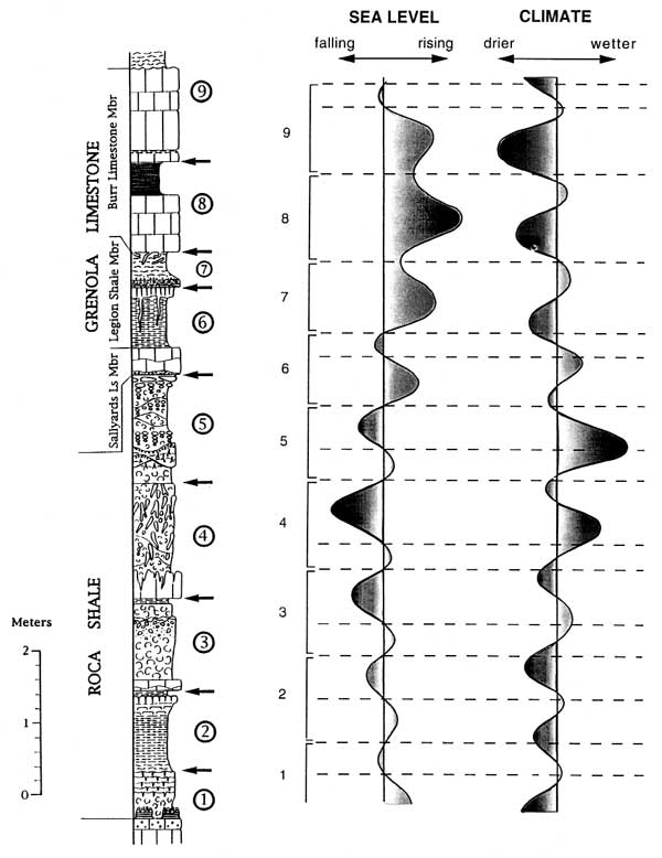
The climatic-eustatic model of Miller and West (1993) provides a basis for constucting both a relative sealevel curve and a climate curve for the cyclothems. Figure 7 presents interpreted curves for the Roca Shale through the Burr Limestone Member of the Grenola Limestone. Two scales of climate change are indicated: one associated with cyclothem deposition and another with the prominent meter-scale cycles. This pattern is consistent with glacio-eustatic curves reconstructed from the Pleistocene isotopic record, where the dominant 100,000 yr. glacial cycles contain superimposed shorter-trem cycles (Denton and Hughes, 1983; Crowley and North, 1991). Assuming a climatic threshold for the transition from carbonate to clastic deposition, fluctuation of the climate between semi-arid and seasonal wet dry conditions would account for the carbonate-to-clastic pattern of the meter-scale cycles for both the paleosol-bearing intervals and the marine intervals. Flooding surfaces and the overlying thin carbonate beds are associated with the driest phase of the climate cycles. Mudstone deposition begins as the climate becomes wetter and the precipitation threshold for clastic transport into the basin is crossed. The climate and sealevel curves are shown to be slightly out of phase based on the evidence for increasingly dry conditions during times of subaerial exposure and paleosol development.
Figure 7. Interpreted relative sealevel and climate curves. The interpreted curves are numerically keyed to the stratigraphic section and show both the larger cylothem-scale patterns and those of the meter-scale cycles. The vertical line for the sea level curve marks the sediment surface, a position to the left of this line representing subaerial exposure and paleosol development. The vertical line for the climate curve indicates the threshold between carbonate precipitation (drier climate) and siliciclastic deposition (wetter climate). Note that marine units record generally drier conditions than the pedogenically altered mudstones. Also note the trend toward wetter climatic conditions upward through the stacked series of paleosols, and the short-term change toward drier conditions during the development of individual paleosols.
The lower Permian cyclothems of the North American mid-continent are characterized by the predominance of shallow water and paralic facies and by variegated mudstone units comprised of stacked paleosol profiles. Within these cyclothems, vertic paleosols, indicative of highly seasonal wet/dry environments, are found to consistently overlie calcic paleosols that record semi-arid to subhumid conditions. Furthermore, prominent meter-scale parasequences display a repeated alternation of carbonate and siliciclastic facies interpreted to record fluctuations in sediment influx in response to cyclic climate change. Combining this climatic cyclicity with reconstructed glacio-eustatic sealevel curves results in the conclusion that sealevel rise, and thus glacial retreat, was associated with drier conditions in the mid-continent. A model is developed that interprets this pattern in terms of the strengthening and weakening of a Pangean monsoon. This model has potential global application to cyclothemic deposition throughout the Permian, and provides a needed integration of climatic effects with existing glacio-eustatic models.
The research for this paper is part of a larger study of Early Permian (Wolfcampian) cyclicity in the mid-continent being conducted by myself, Dr. Ronald R. West, and Dr. Thomas J. McCahon from Kansas State University. Field work was carried out with the permission of the Corps of Engineers under Kansas City District Paleontological Permit No. OF-TC-94-01. Dale L. Forge, Tuttle Creek Project Manager, has been especially encouraging in our ongoing work within the Tuttle Creek spillway area.
Prev--Descriptions of sections || Next--References
Kansas Geological Survey, Geology
Placed on web Feb. 6, 2007.
Comments to webadmin@kgs.ku.edu
The URL for this page is http://www.kgs.ku.edu/Publications/OFR/1994/OFR94_23/page3.html