
![]()
Prev Page--Abstract || Next Page--Description of Mining Areas
Introduction
Purpose of Study
The discovery of "black jack" on the Cook Forty in Galena in 1870 and the closing of the Swalley mine near Baxter Springs in 1970 marked the beginning and end of a hundred years of lead and zinc mining in the Kansas portion of the Tri-State mining district. During much of this time the Tri-State district of southwestern Missouri, southeastern Kansas, and northeastern Oklahoma was one of the world's major producers of lead and zinc. Today the mines are a thing of the past; however, their vestiges are very much a part of everyday life for residents of this area. Whereas the dangers for miners ended with the closing of the last mine, the hazards faced by those living above ground continue to this day. Waste piles, mine shafts, and collapsed mines dot the landscape of the old Tri-State district, and additional areas overlie mines of unknown extent and safety. Over the years, mine collapses have caused extensive property damage and open mines, and other mine hazards have claimed human lives. In an attempt to alleviate these hazards, the residents of extreme southeastern Kansas and adjacent parts of Missouri and Oklahoma sought federal help in the late 1970's; and in 1979, congressmen Whittaker of Kansas, Taylor of Missouri, and Synar of Oklahoma expressed the concerns of their constituents in Washington, D.C., and requested the recommendations of the U.S. Bureau of Mines. Before taking corrective action, the Bureau of Mines proposed a thorough study of the Tri-State mining district to identify all mined areas and mine-related hazards and to make recommendations for remedial action. The Bureau of Mines chose cooperative agreements between itself and the state geological surveys of Kansas, Missouri, and Oklahoma to accomplish this task. This is a final report on the results of the Kansas portion of this study.
Objectives and Scope of Study
The objectives put forward for this study were: (l) to compile, on a single set or series of maps, the location and extent of past-mining activities and the resulting surface effects (underground and open-pit mine workings, shafts, ground subsidence, accumulations of mine waste, and tailing ponds); (2) to identify hazardous areas with potential for future damage to people or property; and (3) to consider methods for providing protection of the public for existing and potentially hazardous conditions.
To meet these objectives, three sets of maps, using U.S. Geological Survey 7 1/2 minute quadrangles as bases, have been prepared for the study area and are included in this report. Plate I, "Underground Mines and Shafts," shows the known extent of underground mine workings as well as the location of all known mine shafts. Plate II, "Open Mine Shafts, Pits, and Subsidences," is essentially a mine hazards map and shows all open or collapsed mine shafts, all open-pit workings, as well as the locations and extent of mine cave-ins and subsidences. Plate III, "Mine and Mill Waste (Piles and Ponds)," depicts the remaining waste piles in the area as well as the extent of former waste piles which have been quarried or reclaimed. Tailings ponds are also shown. To accompany these maps are tabulations of pertinent data describing the nature, location, condition, dimensions, and suggested remedial action for many of the mine features mapped. Tabulations include: Table C-1, "Open Mine Shafts and Pits;" Table C-2, "Subsidence Events;" and Table C-3, "Mine and Mill Waste." [Tables not included in this web version.] Finally, methods are proposed for ameliorating the hazards which exist in the study area.
Information Sources and Study Methods
Mine Maps
To compile the large amount of data required by this study, several sources of information were used. Since drilling and instrumented surveys were not a part of this study, information concerning the location and extent of underground workings had to be taken from existing mine maps. Some of those maps were privately owned or belonged to engineering concerns, a number were on file at the Kansas Geological Survey in the Mineral Resources Section, still others were found in the published reports and articles concerning the Tri-State district.
An extensive cataloging program, conducted by the U.S. Bureau of Mines and reported by Brichta (1), compiled exploration drilling records and mine workings maps for the Tri-State district. Microfilm copies of this information were supplied by the Bureau to this investigation. The maps showing mine workings were compiled on a half-section basis and covered most of the Kansas mining areas. These maps were extremely helpful to this study. The U.S. Bureau of Mines formerly maintained an office in the Tri-State district which contained a large number of mine maps and records produced by mining companies. These maps, which are now housed in the Spiva Library at Missouri Southern State University in Joplin, provided another valuable source of information. Included in this set of maps were a number from the Galena area which were not found among the other map sources. However, maps are still lacking for some mining areas, particularly those in and around Galena.
All the mine maps had to be transferred and plotted on new maps having a scale of 1:24,000. This was accomplished by the use of a Bausch and Lomb zoom transfer scope (Model ZTH-4HP). In addition, the maps held at Missouri Southern State University could not be removed from the premises. These maps were traced, photographically reduced, and then transferred to project maps.
Aerial Photography
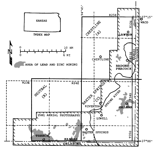
Another major source of information for this study was aerial photography. Photos dating back to 1938 were used in this study to map surface effects of mining and mine hazards and to trace their development over the years. In all, four dates of aerial photography were used: 1938, 1950, 1973, and 1981. The 1938 and 1950 photos were black and white with a scale of 1:24,000, and were acquired by the Agricultural Stabilization and Conservation Service of the U.S. Department of Agriculture. The 1950 photos were on hand at the Kansas Geological Survey; however, the 1938 photos had to be procured from the National Archives and Records Service in Washington, D.C. The 1973 photos were color-infrared transparencies acquired by high-flying NASA research aircraft at a scale of about 1:125,000. These were purchased from the Earth Resources Observation Systems (EROS) of the U.S. Geological Survey in Sioux Falls, South Dakota. In 1981, color photography was acquired especially for this study under subcontract with Anilas, Inc. of Salina, Kansas. This photography was flown in February at a time when the deciduous trees in the study area were without their leaves, thus allowing the search for mine hazards in forested areas. The search for hazards was also aided by the large scale of this photography in comparison with the other sets of photos. Flying at an altitude of about 1,500 meters (5,000 feet), color transparencies were acquired having a scale of 1:10,800. The coverage of this photography is outlined in Figure 1.
Figure 1--Location map of Kansas Tri-State study area showing USGS quadrangles and area of lead and zinc mining.
All of the aerial photography used in this study was stereo-coverage and was interpreted using a Bausch and Lomb zoom 95 stereoscope together with a Richards 924-2XY light table. Mining features were recorded on clear mylar transparencies and later transferred to the 1:24,000 project maps. The aerial photography was useful for mapping all of the surface effects of mining under investigation in this study. The 1938 and 1950 black and white photography was useful for mapping chat piles and tailings ponds which are easily interpreted because of their size and because many were still intact at the time of photography. Since many mines were still in operation on these two sets of photos, especially those from 1938, mineshafts could be located by identifying hoisting structures over their openings. Mine cave-ins are also visible on the 1938 and 1950 photography. These sets of photos, together with the later photography, were used to place time frames on the occurrence of the large mine collapses. The scale, resolution, and--in the case of the 1938 photos--quality, were such that the black and white photography could not be used to map small hazards such as open mine shafts and small areas of cave-in and subsidence. Likewise, the 1973 high-altitude photography, because of its large scale, was useful primarily for mapping and dating large mine cave-ins.
The 1981 photography proved to be invaluable in detecting mine-related hazards as they now exist in the study area. The excellent resolution and sharpness of this photography, together with its larger scale, allowed the mapping of even the smallest mine hazards. A high resolution zoom stereoscope aided in the identification of open, uncollapsed mine shafts as small as 1.2 meters (4 feet) x 1.2 meters (4 feet) even when viewed through a canopy of trees.
Field Work
To gain information on present conditions, dimensions, protective efforts, and other tabulated information, each mine hazard was visited in the field. Required information was recorded and, in many instances, color slides and black and white photos were taken. Many chat piles and tailings ponds were likewise inspected.
To aid in the field work, interpretive overlays made on the 1981 photography were used to make field maps of each square-mile section. In addition to showing the waste piles and ponds, mine shafts and cave-ins taken from the overlays; roads, streams, fences, abandoned rail lines, and other features useful in locating mine hazards were placed on these maps. In this way hazards could be found and inspected without needless searching. Because of the intense mining activity in the Galena area, prints of the 1981 photo coverage were made to assist in this part of the field work. A ground survey of mine hazards in a long orphaned mining district such as this study area, unaided by aerial photography, would have been time-consuming and difficult due to the disrupted landscape the mining has produced and the vegetative overgrowth that has flourished since mining was abandoned.
Personal Interviews
Additional information concerning mine hazards was obtained from personal contacts with area residents, landowners, and city officials. They were particularly helpful in providing the history of some mine cave-ins and in describing past cave-ins that have since been corrected and are no longer apparent. Personal interviews with some landowners provided information on methods used to reclaim their land and close mineshafts. In some instances, former miners told of the conditions in underground mines and how some cave-ins occurred. However, discretion must be used in accepting stories relating to the underground mining in this area since much of what is related results from a strong oral tradition rather than actual experience in the mines. For instance, the notion that all the mines from northeast of Joplin, Missouri, southwest to near Miami, Oklahoma, are interconnected is still held by some residents. More than once stories were related of men entering mines in Missouri and emerging in Oklahoma or vice-versa, including one variation that described the trip being made by row boat.
Description of Study Area
The study area for this investigation is shown in Figure 1 and includes virtually all of the Tri-State mining in the State of Kansas. This study area is composed of the following U.S. Geological Survey 7.5 minute quadrangles in Kansas: Crestline, Baxter Springs, and Neutral, as well as the Kansas portions of: Carl Junction, Missouri-Kansas; Joplin West, Missouri-Kansas; Peoria, Oklahoma-Kansas; Picher, Oklahoma- Kansas; and Miami Northwest, Oklahoma-Kansas.
The study area in Figure 1 covers about 465 square kilometers (180 square miles); however, virtually all of the Tri-State mining activity is contained in the 310 square kilometers (120 square miles) covered by the aerial photography acquired for this project. The study area includes portions of two physiographic provinces as defined by Schoewe (14, p. 279-280) which are roughly separated by the Spring River. To the east lies a small portion of the Ozark Plateau Province which occupies part of northeastern Oklahoma, northern Arkansas, and southern Missouri. The Cherokee Lowlands portion of the Interior Plains make up the remaining part of the study area west of the Spring River.
The Ozark Plateau
The Ozark Plateau Province in Kansas is developed on cherty limestones of Mississippian age. These are the oldest exposed rocks in the state of Kansas and contained the deposits of lead and zinc which were extensively mined in the Tri-State district (Table 1)
Table 1--Generalized columnar section of the surficial rocks in the Tri-State district of Kansas (16, p. 3)
| System | Series | Stage | Geolic Unit |
Avg. Thickness m (ft) |
Description |
|---|---|---|---|---|---|
| Pennsylvanian | Middle Pennsylvanian | Desmoinesian | Krebs Formation | 70 (225) |
Shale, light- to dark-gray, and fine- to medium-grained sandstone contains coal, underclay, siltstone, and some limestone locally. |
| Mississippian | Upper Mississippian | Chesteran | Undifferentiated rocks of Chesteran age |
35 (120) |
Limestone, sha1y, and calcareous shale; contains some oolitic limestone and sandy shale. |
| Meramecian | Warsaw Limestone | 35 (120) |
Limestone, crinoida1; contains much gray chert. Base marked by glauconite-rich layer known locally as the "J-bed". Contains deposits of lead and zinc of commercial value. | ||
| Lower Mississippian | Osagian | Keokuk Limestone | 40 (130) |
Limestone, medium to coarsely crystalline, bluish-gray, and gray chert; contains oolitic limestone near top. Cherty parts weather to characteristic reddish-brown color Contains deposits of lead and zinc of commercial value. | |
| Fern Glen Limestone | 51 (170) |
Limestone. Reeds Spring Limestone Member (upper unit) is cherty, finely crystalline, bluish-gray. Contains deposits of lead and zinc of commercial value. St. Joe Limestone Member (lower unit) is crinoidal, dolomitic in part, green. |
This region contains the highest elevation in the study area and more relief than the Cherokee Lowlands. Being a plateau, the inter-stream uplands are generally flat but have a slight slope to the northwest which approximates the regional dip of the rocks. The stream valleys often have steep sides and gravel-filled bottoms. Local relief exceeds 50 meters (170 feet) along Shoal Creek south of Galena. The overall relief of the study area is over 82 meters (270 feet) ranging from the highest point in the study area, 317 meters (1040 feet) near the three-corners area where Kansas adjoins Missouri and Oklahoma, down to 235 meters (770 feet) where the Spring River leaves the state 8 kilometers (5 miles) to the west.
Much of the Ozark Plateau portion of the study area is mantled by residual cherty gravel that has resulted from the weathering of the Mississippian limestones. The soils of the area are often thin and rocky. These, together with the numerous steep slopes, combine to make much of this area unsuitable for cropland. Deciduous hardwood forests cover most of the hillsides, while the uplands contain large clearings devoted to livestock grazing. Cropland is primarily restricted to the valley floors of Shoal Creek and the Spring River.
Three communities are located in this part of the study area. Riverton and Lowell are two unincorporated villages located near the confluence of the Spring River and Shoal Creek. The city of Galena is located to the east along the Missouri state line on highways U.S. 66 and Kansas 26. The city is divided by westward-flowing Short Creek. The portion of town north of the creek was formerly Empire City, an early rival to the young city of Galena.
Galena and Empire City were born out of the rush to exploit the rich diggings found along Short Creek in the 1870's and grew quickly as additional ore deposits, many occurring close to the surface, were discovered. By 1900, shortly after the peak in mining around the city of Galena, it had a population of 10,155 (3, p. 61). Galena was also an important smelting center, having a large smelter that operated into the mid-1970's. Today, lacking any mining industry, Galena is largely a residential community of 3,588 (1980 U.S. census). However, its history as a mining center is still very much in evidence. Much of the city and adjoining areas are undermined and pockmarked by abandoned mine shafts, prospects, and mine cave-ins. It is possible just by crossing a street or stepping out of a backyard to go from a residential neighborhood to a chat and boulder-strewn wasteland containing all the attendant hazards associated with abandoned underground mines.
The Cherokee Lowlands
The portion of the study area west of the Spring River in the Cherokee Lowlands contrasts sharply with the Ozark Plateau to the east. These lowlands are essentially an erosional plain developed on the soft shales, silts, and sandstones of the Cherokee Group (14, p. 231) which is Pennsylvanian in age. These rocks lie unconformably on the Mississippian rocks below. The lowermost formation of the Cherokee Group, the Krebs Formation (Table 1.), occurs throughout the Cherokee Lowlands portion of the study area. This region is physiographically more subdued than the Ozark Plateau, having gentle slopes and shallow stream valleys. The only notable areas of topographic relief are isolated sandstone hills such as Blue Mound, east of Treece, which stand out as erosional remnants above the surrounding terrain. The elevation of Blue Mound is 295 meters (970 feet). This is the highest point in the study area outside of the Ozark Plateau portion.
The fine-grained, friable rocks of the Krebs Formation have weathered to form deep fertile soils. This, together with gentle well- drained topography, results in much arable land in this part of the study area. Areas of timber are restricted to the slopes of erosional remnants such as Blue Mound and the courses of the larger streams.
Five communities are located in this part of the study area. Crestline and Lawton are two unincorporated villages located in the northern portion. Crestline, on Kansas route 26, is 3.2 kilometers (2 miles) west of the nearest mining. Lawton is 8 kilometers (5 miles) northeast of Crestline. A small area of mining occurs .8 kilometers (.5 miles) south of Lawton, while a larger area exists to the northeast and extends eastward into Missouri toward the town of Waco. Melrose is another unincorporated village located 20 kilometers Cl2 miles) west of Baxter Springs. An isolated mine occurs 3.2 kilometers (2 miles) south of Melrose near the Oklahoma state line. This mine lies out of the study area, but has no associated hazards.
Baxter Springs and Treece are the two incorporated cities in this part of the study area. Baxter Springs, with a 1980 population of 4,762, is located on the west bank of the Spring River on U.S. highways 66 and 166 just north of the Oklahoma state line. The city predates the discovery of lead and zinc ore in the area and owes its beginnings to the Texas cattle drives shortly before and following the Civil War, becoming the first cowtown in Kansas. Today, Baxter Springs still serves the agricultural industry and is also a retail trade center for this corner of the state. Mines do not occur within the city limits of Baxter Springs; however, they are present immediately to the west, northwest, and south and represent the northeastern-most extension of the Picher field. Treece, population 194, is about 10 kilometers (6 miles) west-southwest of Baxter Springs on the Oklahoma state line and is a former mining camp. Treece is located within the Picher field and is surrounded on all sides by abandoned mine workings and is extensively undermined.
Drainage
Most of the study area is drained by the Spring River and its tributaries including Shoal Creek, Short Creek, Turkey Creek, and Center Creek which flow to the west out of the state of Missouri. Cow Creek and Shawnee Creek enter the Spring River from the north and Brush Creek and Willow Creek flow southeasterly, entering the Spring River in the vicinity of Baxter Springs. The Spring River and Shoal Creek are impounded by dams between Lowell and Riverton, Kansas. The dam at Lowell was constructed by the Southwestern Power Company which later became a part of the Empire District Electric Power Company of Joplin, Missouri. This darn was built to generate hydroelectric power for use in the nearby mines (6, p. 80). Spring River joins the Neosho River 26 kilometers (16 miles) south of Baxter Springs in the upper end of Grand Lake of the Cherokees in Oklahoma. That part of the study area southwest of a line extending northwesterly from a point 5 kilometers (3 miles) southwest of Baxter Springs is drained by streams flowing into the Neosho River. The most important of these is Tar Creek which leaves Kansas near Treece and drains much of the Picher field. It joins the Neosho River near the town of Miami, Oklahoma
General Mining, Milling, and Economic Geology
The quantity of zinc and lead produced from the mines of the Tri-State district of Oklahoma, Kansas, and Missouri helped make the district one of the most important metal-mining areas in the world. During the 100 years from 1850 until 1950 the Tri-State accounted for 50 percent of the U.S. production of zinc and 10 percent of the production of lead (6).
Important years when the major mining activity occurred in the district were between 1880 and 1955 (6, p. 401).
The Kansas portion of the district has produced more than 2.9 million tons of zinc with an estimated value of 436 million dollars, and 650 thousand tons of lead worth nearly 91 million dollars (9, 18). The cumulative production of the Kansas ores, based on the above data, between 1876 and 1970 are shown in Figure 2. Distribution of the metal concentrates to various Kansas subdistricts of the Tri-State is summarized in Table 2.
Figure 2--Cumulative production of recoverable lead and zinc from mines in Kansas (data from 9, 18). Figure from Ebanks (5, p. 24).
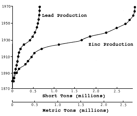
Table 2--Quantity of material treated from Kansas and average recovery of zinc and lead concentrates during 1911-1945. Data from Martin (9, p. 1-2).
| Subdistrict | Material Treated | Concentrate Recovery % | ||||
|---|---|---|---|---|---|---|
| Crude Ore (short tons) |
Old Tailings | From Crude Ore | From Old Tailings | |||
| Zinc | Lead | Zinc | Lead | |||
| Badger-Peacock1 | 389,365 | 469,045 | 3.72 | 0.43 | 0.34 | .0001 |
| Baxter Springs-Blue Mound-Treece | 56,718,899 | 25,205,717 | 5.42 | 8.88 | 0.97 | .010 |
| Galena | 4,597,884 | 183,218 | 3.37 | .59 | .76 | .040 |
| Lawton-Waco2 | 5,708,831 | 2,015,900 | 4.79 | .02 | 1.09 | |
| Playter-Crestline3 | 1,490,700 | 32,500 | 2.70 | 1.26 | 1.65 | |
| Totals | 69,905,679 | 47,906,380 | 5.17 | 0.79 | .96 | .010 |
| 11922-1924 included with Crestline District 21911-1912 included with Badger-Peacock District 31922-1924 included with Badger-Peacock District |
||||||
The general method of winning the Tri-State ores was by underground mining using room and pillar methods. However, the occurrence of ore bodies near the surface in the eastern part of the district resulted in some mining companies trying open-cut mining methods, especially in the Galena area and in Missouri.
North and west of the Galena field, the Cherokee Group of shale, sandstone, and coal beds of Middle Pennsylvanian age overlie the ore-bearing carbonates of Mississippian age. The Cherokee Group becomes progressively thicker away from the Galena area due to the regional northwest dip of the rocks and the increase in surface elevation in a west and north direction. With the increase in Cherokee thickness, the deeper mines were in the western part of the Tri-State, with the Foley Mine being the deepest mine in the Tri-State district with a shaft at 146 meters (480 feet) of depth. This mine was located 1.6 kilometers (one mile) north of Treece in the Picher field.
Sphalerite and galena are the commercial ore minerals that were mined in the district. McKnight (10, p. 101) lists marcasite and pyrite as commonly occurring with the ores, and the common gangue minerals include jasperoid, dolomite, calcite, and occasionally quartz or barite. A detailed discussion of the mineralogy of the Tri-State district is covered in McKnight (10, p. 101-124) and in Brockie (2, p. 414, 416- 417)
Forms of the ore bodies have been described by Brockie (2) as assuming three basic shapes: (1) irregular, relatively narrow, long ore "runs" of varying heights; (2) circular "runs," and (3) flat-lying, generally tabular bodies called "sheet ground" that cover large areas. The most important type of ore body shape in the district was the elongated "long runs."
In addition to the zinc and lead produced in the Tri-State, the district was also an important source of cadmium and germanium that were produced as a by-product of the zinc-lead smelting process. The summary report on germanium by the U.S. Bureau of Mines (19, p. 927-929) describes the Eagle-Picher Industries, Inc., of Quapaw, Oklahoma, as the sole domestic producer of primary germanium. The refined germanium is produced from stockpiles of old smelter residues from the zinc-mining operations in the Tri-State district.
Cadmium is produced as a by-product metal from the smelting of zinc. Mote (11, p. 188) noted that the average content of cadmium from zinc concentrate in the Tri-State district was 0.35 percent. No primary production of cadmium from zinc concentrate was listed by Mote (11) for Kansas. However, production of cadmium was listed for smelters in Bartlesville and Henryetta, Oklahoma. A similar figure for cadmium content is given by Martin (9, p. 5) for Tri-State ore. Martin (9) lists the zinc concentrates as usually containing 0.30 to 0.40 percent cadmium, and that some of the cadmium is recovered at the smelters.
In 1960, Shelton (17, p. 291) listed cadmium production by two companies in Kansas--Sherwin-Williams Company at Coffeyville and the Eagle-Pichen Company at Galena. No estimate can be made of the cadmium metal obtained from the zinc smelting of Kansas zinc concentrates.
The large piles of chat that accumulated from milling of the ore are a valuable commodity used for concrete aggregate, road construction, and as ballast on railroad beds. Kansas chat is composed of small fragments or chips of flint or chert and limestone (15, p. 454).
The quantity of chat used for construction purposes between 1924 and 1956 was estimated by Schoewe (15, p. 424) at 19 million tons. Value of the quantity of chat consumed was estimated by Schoewe (15) at 5.7 million dollars. Nearly 13 million tons of the 19 million tons total was utilized between 1950 and 1956. Based on information reported to the U.S. Bureau of Mines by mineral producers, there was an estimated 10 million tons of chat utilized since 1956 from the Kansas portion of the Tri-State.
Reserves of Zinc and Lead
An extensive estimate of reserves of zinc and lead in the Tri-State district was undertaken by the U.S. Bureau of Mines in the mid-l940's (13). Their work was based on a thorough evaluation of the mines and over 68 thousand drill records for the district. In addition, consideration was given to all the known geological features and conditions of the district. The results of the study were based on work completed by December 31, 1947, with a lower cut-off value for reserves of both 1 1/2 percent and two-percent zinc and lead combined.
Only the reserves with two percent metal values were considered in this report. Minimum rock thickness considered for reserve considerations by Ruhl (13, p. 7) was 7 1/2 foot face for 1.5 percent metal values and a six foot face for a 3 percent average metal value interval.
Results of their study for reserves of zinc and lead ore for Kansas, with a two percent combined zinc and lead cutoff value, show a recoverable value for Kansas of 7,546,700 tons of indicated reserves having recoverable average concentrate values of 4.57 percent zinc concentrate and 0.63 percent lead concentrate. This corresponds to approximately 2.74 percent zinc and 0.50 percent lead. In the inferred reserves category, Ruhl (13, p. 16) shows 3,375,500 tons of inferred ore with 3.99 percent zinc concentrate and 1.09 percent lead concentrate. This corresponds to a metal content of approximately 2.39 percent zinc and 0.87 percent lead. No measured ore reserves were included in the study for Kansas, although Oklahoma and Missouri have reserves in the measured classification.
At the time of calculation of these reserves, 2,670,800 tons of ore in all classes were under water in Kansas (13, p. 17-18). This area includes part of the Galena, Crestline, and Lawton subdistricts.
In 1964, McKnight (10, p. 101) noted for the Picher field that, "The bulk of the remaining reserves in the field are marginal in grade and can be mined only so long as economic conditions remain favorable." Abandonment of pumping in the Picher field due to economic slow-down would probably result in loss of the remaining low-grade reserves. McKnight (10, p. 101) further elaborated on this fact by describing the Picher field mine workings as being so extensive and interconnected that the cost of pumping them out again, once flooded, would be prohibitive when balanced against the tonnage and grade of the remaining reserves.
The last operating mine in the Kansas portion of the Tri-State district was the Swalley Mine located just west of Baxter Springs that was operated by the Eagle-Picher Industries, Inc. This mine closed in 1970 and along with it the last pumpage of water from the mining district.
The quantity of water required to be pumped from the field for mining was enormous. Ruhl (13, p. 27) describe the volume of water pumped in the Oklahoma-Kansas portion of the district alone as totaling over 36 million gallons a day in 1947. This volume of water was handled by 63 pumping plants, with 28 of this total located in Kansas in the Picher field area.
For a chemical quality study of water in abandoned zinc mines within the Picher field area (12, p. 2), observations of water in a well located in the mine workings showed an average rise of 1.2 feet per month. This was the observed average for a period of time from September 1975 to June 1977. In the same report D. C. Brockie, then chief geologist with Eagle-Picher, was quoted as saying that the abandoned mines were filling with highly mineralized water that by mid-1976 contained an estimated 100,000 acre-feet of water.
Based on the reserve figures of Ruhl (13) for a two-percent ore cutoff, the metal remaining in 1947 was approximately 287 thousand tons of zinc and 67 thousand tons of lead. Subsequent drilling of the Kansas portion of the district would have proved-up larger amounts of reserves than those calculated by the Bureau of Mines personnel. However, totals of zinc and lead extracted during the time period of 1948-70, as shown in the U.S. Bureau of Mines yearbooks, show totals for Kansas of over 297 thousand tons of zinc and nearly 80 thousand tons of lead.
In summary, reserves, or at least resources of zinc and lead ore, undoubtedly remain in the district even though they would be nearly depleted in the old mined areas. It is questionable if the remaining resources in the old subdistricts will be mined in the Kansas part of the Tri-State district in any foreseeable future because of several factors:
- The ore is nearly depleted except for marginal low-grade ore that would require a large price increase in zinc for further consideration of mining.
- Dewatering would be necessary on a very large scale to resume mining in the old district.
- Quality of the water from dewatering or mining would require very costly clean-up before release into adjacent stream valleys under the new federal water-quality laws.
Most present-day exploration for zinc and lead in Kansas is well on the margins of the old mining areas and, if a new mine were to be developed, it would probably be on the margins of the older field and would have little or no affect on reclamation of the previously mined areas.
Land-Ownership Patterns in the Kansas Portion of the Tri-State Mining District
Essentially all of the surface and mineral rights to land in the Kansas portion of the Tri-State area are under private ownership. Government ownership is limited to the highways and roads of the area and a few acres of city-owned land within and adjacent to the towns and cities in the district. In the Kansas study area there are approximately 27,320 hectares (67,500 acres).
Excluding the roads and highways and land ownership within the city limits, corporate ownership amounts to approximately six percent of the surface ownership and seven percent of the mineral rights ownership. The largest corporate owner is the Gulf Oil Corporation with nearly 770 hectares (1,900 acres) present within the study area in Township 33 and 34 South, Range 25 East. Outside of the city boundaries local government land ownership consists of less than 80 hectares (200 acres).
Even among the properties with the mineral rights severed from the surface rights, Ownership by private individuals prevails. Evaluation of Cherokee County records indicates that nearly 1,450 hectares (3,600 acres) of mineral rights were severed from the surface rights. Of this total amount of severed mineral rights, mining companies own partial mineral rights to nearly 160 hectares (400 acres) with an additional corporate ownership of 65 hectares (160 acres). The other severed mineral rights are owned by private individuals or estates.
In general, any additional mining or reclamation of past mining abuses of the surface or subsurface can be completed by private agreements, usually dealing with individuals who presently own the land.
Kansas Laws
Important laws that exist on the Kansas statute books that pertain to the problems of the open pits and open shafts are found in Chapter 19.
Article 25, "Wells and Excavations," allows for the protection of the general citizen by requiring the landowner to enclose, fill, or securely cover any abandoned wells, pits, mines, or other excavations that are not enclosed (Section 19-2504). Upon a citizen complaint in writing, the owner has 20 days to properly protect the problem well or excavation (Section 19-2505).
Possible action for failure to comply with the request is discussed in Section 19-2505; that section provides for filing with the township trustee the complaint to the landowner. The township trustee must make an investigation to determine if the well, pit, mine, or excavation is dangerous. If determined to be dangerous, the trustee shall correct the problem by filling or covering, and the cost for correction of the problem is assessed against the land by the county treasurer.
Reimbursement of expenses for the problem correction costs are authorized in 19-2506 for the county commissioners to pay back the township trustee the expenses from the county's general fund.
Sections 19-2504, 2505, 2506 became law in 1895 with modification in 1923.
These laws exist in the Kansas statutes, but their utilization is obviously very limited because of the numerous problem openings that still exist in the area. Appendix A contains these Kansas statutes.
Federal Laws
Federal laws that would apply to the problems associated with post-mining activities of the Tri-State are very limited. Of direct interest are the hazardous problems associated with abandoned shafts, tunnels and entryways, and surface impacts of underground and surface mines, that are covered in portions of the Surface Mining Control and Reclamation Act of 1977 (PL95-87).
This law allows for abandoned mine reclamation through the establishment of a trust fund called the "Abandoned Mine Reclamation Fund." This fund is generated from fees paid in by surface and underground coal mines and is administered by the U.S. Secretary of the Interior. The intent of the fund is for reclamation and restoration of land and water resources adversely affected by past coal mining and the protection of public health, safety, general welfare, and property from extreme danger due to the adverse effects of coal mining.
Where voids, open and abandoned tunnels, shafts, and entryways resulting from any previous mining operation constitute a hazard to public health or safety, the Governor of the state can request approval of funds for reclamation of the problem. This can be done under this law even when the problem was the result of mining for non-coal minerals (Section 409).
It is unlikely that such a request will be made in Kansas for reclamation of the lead-zinc problem area when an excess of 40,000 surface acres of disturbed and unreclaimed land resulting from coal mining remains in the state. In addition, there are nearly 60,000 acres of old underground coal mines in the state, some with pollution and subsidence problems. In Kansas the Mined-Land Conservation and Reclamation Board is the regulatory group designated by the Governor to administer the state portion of the Abandoned Mine Reclamation Fund. The stated intent of the Mined-Land Board is to utilize the money available in the Kansas fund to help solve the problems generated by coal mining with other mining considered only after the coal problems are resolved. With potential annual income to the state of 150 to 350 thousand dollars, reclamation of lands other than those mined for coal are unlikely under this Act (PL95-87).
Several other federal laws have strong impact on present mining, including the Federal Water Pollution Control Act Amendments of 1972 and 1977 that regulate mining waste water and the Clean Air Act and its amendments that set significant air standards for several air contaminants, many of which would apply to mining and mineral processing. None of these laws affect the abandoned zinc-lead mines of the Tri-State district.
Prev Page--Abstract || Next Page--Description of Mining Areas
Kansas Geological Survey, Tri-state Mining Area
Comments to webadmin@kgs.ku.edu
Web version May 2004. Report from January 1983.
URL=http://www.kgs.ku.edu/Publications/OFR/1983/83-2/03_intro.html