
Kansas Geological Survey, Open-file Report 82-2
Geohydrology of Southwestern Butler County, Kansas: A Preliminary Report
by Howard G. O'Connor, Pamela Chaffee, and Martha Link
Prepared at the Request of the Butler County Commissioners,
County Engineer, and County Zoning Administrator
KGS Open File Report 82-2
May 1982
Introduction
At the request of the Butler County Commission, a meeting was arranged with the Kansas Geological Survey to discuss what kinds of assistance or useful hydrogeologic information could be provided to the County Commissioners, County Engineer, and County Zoning Administrator to assist them in administering their responsibilities.
A meeting was held at the Kansas Geological Survey's Foley Geohydrology Center on March 23, 1982 attended by the following persons:
- John Tipton--Butler County Zoning Administrator
- Ted Farmer--Butler County Engineer
- Tom M. Linot--Butler County Commission
- J. W. Simmons--Butler County Commission
- Eldon Phillips--Butler County Commission
- William W. Hambleton, Director--Kansas Geological Survey
- Jane Denne, Geologist--Kansas Geological Survey
- Howard G. O'Connor, Geologist--Kansas Geological Survey
- Manoutch Heidari, Civil Engineer--Kansas Geological Survey
- Pat Cobb, Hydrologist--Kansas Geological Survey
The county officials described the rapid growth in the suburban and rural areas which are not served by public water supplies and sewers. Their problem is in knowing how to respond to developers and individuals who want to construct homes in the rural and small tract subdivision developments. The county officials needs are for reliable information about the soils, geology, and the quantity and quality of groundwater available so that they can develop meaningful rules, regulations, and policies which will protect the public health and property values and promote orderly growth. This information is needed for all of the county, but especially southwestern Butler County where small tract development is most rapid and problems are greatest.
Dr. Hambleton responded with a summary of the kinds of information that is available at the Kansas Geological Survey. The staff is fully committed to projects already in progress and institutional and funding restrictions are such that we could not move any staff into a Butler County research project now or in the very near future. He indicated some work was done in Butler county in the early and mid 1960's. Some of the data was published in USGS Water Supply Paper 1982, "Chemical Quality of Water in the Walnut River Basin, South-Central Kansas," but much of the groundwater data remains unpublished.
The county officials asked if the Kansas Geological Survey could provide any kind of interim report for the southwest part of Butler county, their area of greatest need, based only on data already available. Dr. Hambleton agreed to assign one staff member and one or more part-time graduate research assistants to prepare a preliminary report on the geohydrology of an area two townships wide by four townships tall (R3 and 4E, T26, 27, 28, and 29S) in the southwest part of Butler County as quickly as possible.
Following a review of the in-house data, it was agreed to prepare a brief interpretative report, supplemented by maps and tables. The interpretative report and any recommendations deemed advisable would be presented by one of the Kansas Geological Survey staff at a meeting with the Butler County officials as soon as possible and be available to answer questions.
A project proposal for a full-scale study of Butler County, together with a time schedule and cost estimate for the complete study would also be prepared. Dr. Hambleton indicated that Kansas law allows financial cooperative agreements between counties, through the county commissions, and the Kansas Geological Survey (KSA 76-326a). Cooperative financial support by the county would allow KGS to hire additional staff and allow an earlier start of the project.
Geologic Framework
The rocks which contain fresh or useable water are of Quaternary and Permian age. Quaternary rocks are relatively young rocks (less than 2 million years old) and are shown in Plate 1 as the alluvium in the stream valleys and as thin loess or wind laid silt deposits in parts of Township 26, 28, and 29S, R3E.
The thickness and water bearing characteristics of the alluvium and loess deposits are summarized in Table 1 and Figure 2.
The Permian rocks, about 270 million years old, consist of more or less flat lying to gently sloping alternating layers of shale and limestone beds. They have a regional slope of about 20 feet per mile westward except along the Nemaha anticline (Fig. 1). The Permian rocks dip or slope more steeply westward along the west side of the Nemaha anticline and slope eastward along the east side of the anticline. The Nemaha anticline is the principal local structure in the study area.
Figure 1--Map showing regional joint patterns and location of axis of the Nemaha anticline (adopted from Ward, 1968).
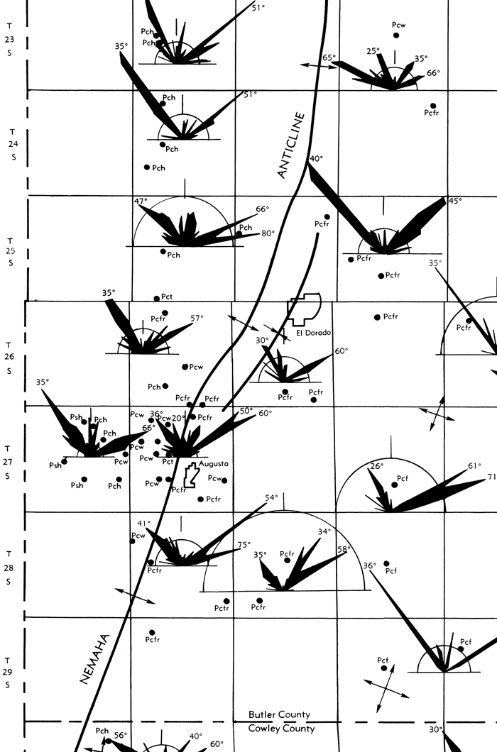
Table 1--Generalized section of outcropping rock units in southwestern Butler County and their water-bearing characteristics (adopted from Bayne, 1962; Leonard, 1972; and WWC-5 records).
| System | Series | Group | Formation | Thickness (ft) |
Character | Water Supply |
|---|---|---|---|---|---|---|
| Quaternary | Pleistocene | Alluvium | 0-50 | Silt, clay, limestone and chert sand and gravel fragments. | Small (0-10 gpm) to moderate (10-100 gpm). Yields of generally good, but locally poor quality water in principal stream valleys. Locally polluted by past oil and gas activities. | |
| Loess | 0-10 | Wind laid deposits of silt on upland areas. | Lies above water table and yields no water to wells. | |||
| Permian | Middle Permian |
Sumner | Wellington | 0-100 | Light gray and green silty shale contain thin limestone and gypsum beds. Contains the Hollenberg Limestone. | Small to moderate quantities of generally hard water is obtained from permeable thin limestones and gypsum beds. |
| Lower Permian |
Chase | Nolans Limestone |
20-30 | Light-buff limestone and dolomite in upper part. Sandy dolomitic appearance; contains siliceous geodes, locally chert nodules. Middle part blue to gray shale, lower few feet is gray limestone or limestone and shale. | Yields moderate quantities of groundwater to many wells from solution channels in the upper limestone bed. | |
| Odell Shale |
30-40 | Chiefly gray and green calcareous shale. Locally dolomitic in the upper and middle part. | Yields little groundwater to wells. | |||
| Winfield Limestone |
20-30 | Light blue to white thin bedded limestone overlying massive light buff limestone; locally contains chert nodules. | Yields small to moderate supplies of water to wells from solution zones. | |||
| Doyle Shale |
85-95 | Upper Gage shale Member is gray, green, and red clay shale, calcareous at top. Thickness about 40-50 feet. Middle Towanda Limestone Member is about 5-15 feet thick, buff to gray, locally gypsiferous. | Yields small moderate supplies from permeable zones in the Towanda Limestone. Water may be high in sulfate. | |||
| Barneston Limestone |
75-85 | The upper Ft. Riley Limestone member is 45-55 feet thick and consists of both massive and thin bedded limestone. Lower Florence Limestone member is 25-35 feet thick, gray to buff limestone interbedded with chert. | Yields small to large supplies of water from fractures and solution channels. Supplies water to many many wells and springs. | |||
| Matfield Shale |
60± | Upper and lower gray, green and maroon shale beds separated by about 15 feet of limestone and gray limey shale. | May yield small supplies of water to wells from the middle limestone beds. |
The shale beds of the Wellington Formation (Sumner Group) consist principally of gray and greenish shale beds but also include thin limestone and gypsum beds. Below the Wellington Formation, in downward sequence are the Nolans Limestone, Odell Shale, Winfield Limestone, Doyle Shale, Barneston Limestone and Matfield Shale, all parts of the Chase Group of rocks (Fig. 2). These are the units considered to provide the domestic water supplies of the area. The thickness and general character of the rocks are shown in Table 1 and Figure 2.
Figure 2--Generalized graphic section of outcropping and near surface rocks in southwestern Butler County (adopted from Leonard, 1972).
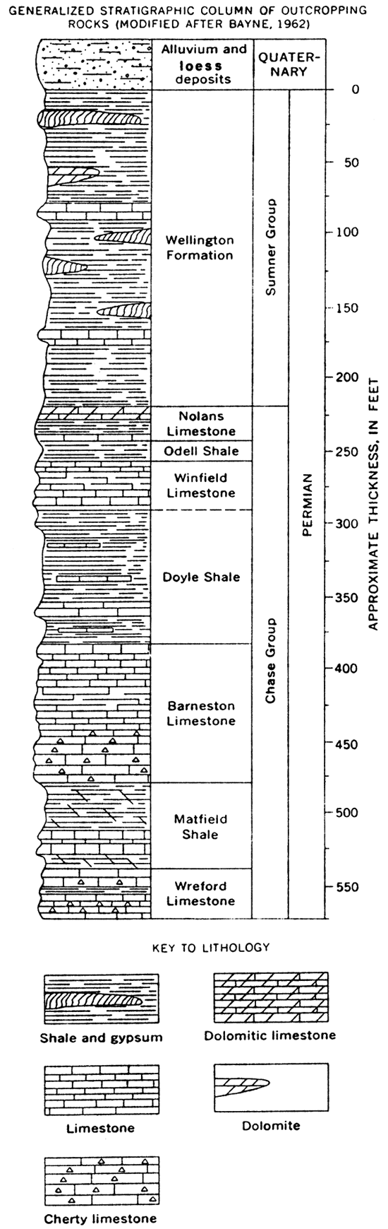
Each of the major limestone units contains one or more zones having significant solution permeability and the Nolans and Barneston Limestone contain zones having abundant chert or silicous concretions. The Towanda Limestone member of the Doyle Shale may be gypsiferous and locally contains solution permeability. The shale units consist of gray, green, tan and red silty to calcareous shales, thin limestones and locally gypsum beds, but below a depth of about 50 feet are considered relatively impermeable or of very low permeability with respect to vertical groundwater flow.
Regional Hydrology
Groundwater suitable for domestic and stock use occurs in both the unconsolidated Quaternary alluvial stream valley deposits, and the consolidated Permian limestone and shales at maximum depths ranging from about 100 to 175 feet. The limestone have two dominant sets of fractures trending northeast and northwest as shown on Figure 1. The ability of the fractures to store and transmit groundwater is greater where the rocks are at or near the land surface (< 30 feet) because various weathering processes tend to cause the fractures to open or to enlarge as a result of solution of the rock by moving groundwater. In addition, at depths below about 30 to 50 feet there are one or more primary permeable zones in nearly all of the thicker limestone units such as the Nolans, Winfield, Towanda and Barneston limestones. Horizontal or nearly horizontal primary solution permeability zones developed soon after the limestones were deposited and consolidated, but before they were deeply buried. Because the primary horizontal solution zones in the limestones have not removed all of the limestone in the solutioned zone, every small diameter bore hole drilled through the solutioned zone may not penetrate a water filled solution channel or interconnected voids. These zones may contain rather significant quantities of water adequate for reliable domestic and stock supplies.
For example if we have a one-foot thick zone with 15 percent of the limestone removed by solution leaving 15 percent of the one-foot zone as void space filled with water in solution channels, we would have almost 50,000 gallons of water stored in this zone under each acre of land. Typically water wells which penetrate the primary solution zones may be expected to have small (1 to 10 gallons per minute [gpm]) to moderate (10 to 100 gpm) yields to properly constructed wells.
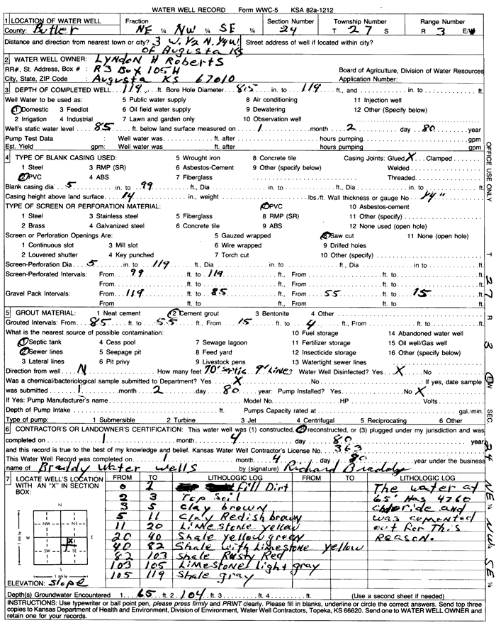
A review of more than 415 Water Well Records (WWC-5 forms) available for southwestern Butler County indicates many of the bore holes encounter 1, 2, or even 3 permeable water bearing zones. Four WWC-5 records are included as Figures 3-6 for reference. Figure 3 indicates three water-bearing zones were penetrated by this well; the upper water zone at 48 feet depth has been grouted out to exclude this water from the well. The lower two water-bearing zones have been hydraulically connected to contribute to the well yield by means of a permeable gravel pack around the casing from 58 to 138 feet depth and screen perforation intervals from 118 feet to 138 feet depth. Figure 6 shows a well which penetrates two water-bearing zones, at 65 feet and 104 feet. The water at 65 feet was grouted out of the well because this zone contained water having 4,760 mg/l chloride which would make it unfit for domestic use. The water in the 104 foot zone apparently was of satisfactory quality because it is used for domestic purposes.
Figure 3--Selected WWC-5 water well record for sec. 24, T. 27 S., R. 3 E.
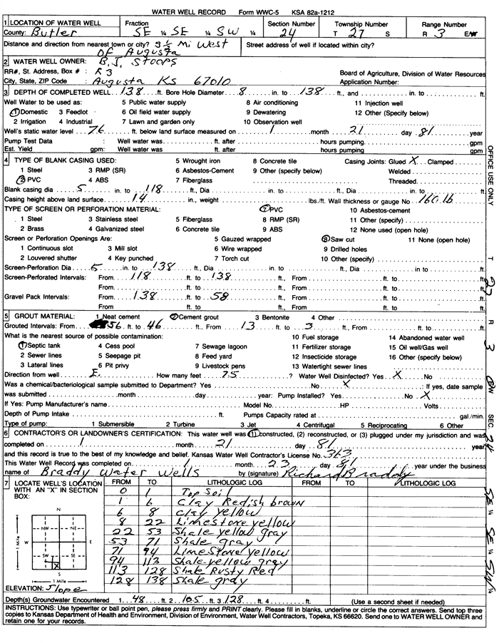
Figure 4 describes an 80-foot well penetrating only one permeable water-bearing zone at 68 feet depth. The well was drilled with a cable tool or percussion drilling rig, drilling a 10-inch diameter hole. Six-inch diameter casing was set to the full depth of the hole. The anular space between the sides of 10-inch hole and the outside of the 6-inch casing was grouted between 3 and 13 feet depth and the remainder of the anular space from 13 to 80 feet was left open. The limestone logged at 13 to 37 feet includes the Nolans limestone known to have one or more permeable zones and at this depth probably contains permeable open fractures. It apparently lies above the local water table or includes an intermittent water table in wet years. Hindsight suggests this well should have been grouted from 3 to about 40 feet depth to preclude entrance of any shallow groundwater in years of above average precipitation when a shallow zone of saturation may be present and contribute potentially poor quality water to the well.
Figure 4--Selected WWC-5 water well record for sec. 26, T. 27 S., R. 3 E.
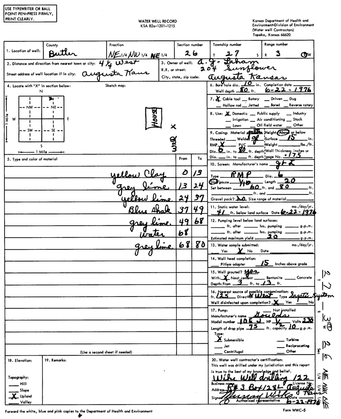
Figure 5 represents a well in which either the written location (sec 21) or the reported legal location (sec. 33) is in error. Based on geologic mapping of the area at either the written location or legal location, one or more of the Permian limestones should have been penetrated by a well 115 feet deep.
Figure 5--Selected WWC-5 water well record for sec. 33 (?), T. 27 S., R. 3 E.
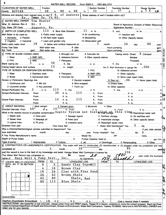
Figure 6--Selected WWC-5 water well record for sec. 24, T. 27 S., R. 3 E.
The quality of water obtained from the aquifers in southwest Butler County has been shown graphically in USGS Water Supply Paper 1982. Dissolved solids in groundwater ranges from less than 500 mg/l (very good) to nearly 3,000 mg/l (marginally acceptable) in wells used for domestic and stock purposes. Dissolved nitrate concentrations are relatively low in most wells but are excessive for good drinking water in 10 to 20 percent of the wells. In some wells the dissolved sulfate (SO4) exceeds the recommended limit of 250 mg/l for domestic water by 4 to 5 times, and probably reflects groundwater that is associated with dissolving gypsum beds. Groundwater high in sulfate also is very hard.
The chloride (Cl-) content of groundwater generally is relatively low and below the recommended limit of 250 mg/l for drinking water in all of the groundwater aquifers except where they have been contaminated by oil field brines. Because of the extensive oil and gas developments in the years 1914 to 1945, when there were no regulations regarding disposal of oil field brines, both the area streams and many of the groundwater aquifers were extensively polluted. In general, the produced oil field brines are disposed of today in an acceptable way by deep disposal and the polluted streams and the quality of water in groundwater aquifers is improving as the brines are slowly flushed from the area aquifers.
Recharge and Discharge
Recharge occurs to the local aquifers primarily in response to local precipitation on the area. The area averages about 31 or 32 inches of precipitation annually. The amount of the precipitation that becomes groundwater recharge is not known, but has been estimated to be about 10 percent of the precipitation or about 3 inches annually. Plate 2 is a map showing the water table or potentiometric surface for southwestern Butler County and the location of water wells and stream elevations used for construction of the map. The water table or potentiometric surface generally is a relatively smooth surface which slopes toward the area streams. Groundwater discharge provides the base flow of the streams.
Some areas such as the vicinity of Sec. 24, T27S, R3E present anomalies that are difficult to understand. The high water levels appear to indicate anomalous recharge. In another area near Santa Fe Lake the water table or potentiometric surface could not be contoured in a meaningful manner. Some of the contours in the valley areas seem displaced or skewed.
Considering that the data used (>415 WWC-5 records) represented water levels taken at different times between 1975 and 1982, that some water well locations were inaccurate, that some water levels represent resultant water levels of two or more hydraulically connected aquifers, and that absolutely nothing was checked or verified by field work, the map was more successful then originally anticipated. No long-term hydrographs or historical water level records were available.
Summary and Recommendations
Southwestern Butler County is underlain by Quaternary alluvial deposits in the stream valleys which contain generally good quality groundwater except where the aquifers have been polluted by brines associated with past production of oil and gas. The alluvium generally provides small to moderate yields to wells 30 to 50 feet deep in the principal valley areas. The Quaternary loess deposits lie above the water table and are not aquifers.
The Permian rocks comprise alternating shale and limestone beds and include the Wellington Formation, Nolans Limestone, Odell Shale, Winfield Limestone, Doyle Shale, Barneston Limestone, and Matfield Shale that provide groundwater suitable for domestic and stock water supplies. wells may be as deep as 175 feet. The Wellington Formation is fairly extensive at the surface in the western part of the study area. It contains thin limestone and gypsum beds which provide small to moderate yields of hard water and locally water high in SO4 to domestic and stock wells.
The Nolans, Winfield, and Barneston limestones each contain one or more permeable water zones that produce small to moderate yields to wells where the permeable zones are below the water table or in the zone of saturation. The water quality ranges from very good to marginally acceptable in terms of dissolved solids, sulfate, and chloride values. Typically groundwaters associated with dissolving gypsum beds may have dissolved solids and sulfate values in the higher range of values but such water can be used if better is not available.
An evaluation of the available Water Well Records indicates many are incorrectly located, have poor lithologic descriptions, and the wells are constructed to meet the minimum standards set by the Kansas Department of Health and Environment rather than to best fit the problems of the local geology. Many of the wells hydraulically interconnect two or more aquifers allowing water to flow upward or downward from one water zone to another. Because-the shallower zones typically have higher water levels or hydraulic heads the shallow aquifers tend to drain to the deeper aquifers. Wherever well density is low, such as one well per 80 acres, hydraulically connecting two or more aquifers may not cause a significant problem. Where well density becomes greater as in small tract developments, having one well per 1 to 5 acres, wells hydraulically connecting two more aquifers may have a significant affect and may partially, completely, or intermittently drain the shallow aquifer. Where small tract developments occur that utilize septic tank systems for waste disposal, an additional dissolved solids load to the shallow aquifer may be imposed resulting in increased dissolved solids, nitrate, and chloride values. Techniques are available to calculate the kinds of residential spacing that should be maintained to provide acceptable increases in dissolved solids, nitrates and chloride to the shallow aquifer, but could not be determined in this preliminary report.
Well construction should receive more attention in small tract developments so that existing wells in the shallow aquifers are not drained and well construction should not allow hydraulic interconnection of aquifers by wells if such practices will cause detrimental effects to the local aquifers.
A number of local problems associated with past oil and gas activities, improper well plugging, hydraulic interconnection of aquifers, rate and direction,Qf groundwater movement, water chemistry, aquifer properties (transmissivity and storage) need to be determined with a planned investigation that would involve field work, development of historical water level and water quality records, hydrographs, and recharge rate determinations. Depending on staffing and support for such a study, it is anticipated such a project would require 24 to 30 months for completion.
There is a need for an education and technical exchange program for the water well contractors to improve their understanding of problems and to provide better well construction and better quality Water Well Records.
Selected References
Bayne, C.K., 1962, Geology and ground-water resources of Cowley County, Kansas: Kansas Geological Survey, Bulletin 158, 219 p. [available online]
Kansas Geological Survey, 1964, Geologic Map of Kansas: Kansas Geological Survey, Map M-1, scale 1:500,000.
Kansas Geological Survey, Public file of WWC-5 Water Well Records. [available online]
Leonard, R.B., 1972, Chemical quality of water in the Walnut River Basin, south-central Kansas: U.S. Geological Survey, Water Supply Paper 1982, 113 p.
Ward, J.R., 1968, A study of the joint patterns in gently dipping sedimentary rocks of south-central Kansas: Kansas Geological Survey, Bulletin 191, pt. 2, 23 p. [available online]
Plates
- Plate 1--Areal geology of southwestern Butler and location of water wells for which records are available.
- Acrobat PDF file, 3.4 MB
- Plate 2--Water table or potentiometric map of southwestern Butler county showing location of water wells and stream elevations used.
- Acrobat PDF file, 3.2 MB
The text of this report is also available as an Adobe Acrobat PDF file.
Read the PDF version (44 kB)
Kansas Geological Survey
Placed online June 10, 2011; originally released May 1982
Comments to webadmin@kgs.ku.edu
The URL for this page is http://www.kgs.ku.edu/Hydro/Publications/1982/OFR82_2/index.html