![]()
![]()
![]()
![]()
![]()
![]()
![]()
![]()
David A. Grisafe, Kansas Geological Survey
The Kansas River has cut through many limestones, shales, clays, and occasional sandstones of Upper Pennsylvanian age in the lower or eastern portions of the valley and Lower Permian age in the upper or western portions of the valley. The limestones are by far the most important from an economic standpoint. Many different limestone members, located near the river, have been used as resources for crushed stone, and a few limestones have been used for building stone. The crushed limestone is mostly used for aggregate in concrete and asphalt and for road surfaces. For industrial mineral purposes, aggregate is used to describe any hard, inert material used for mixing with a cementing or bituminous material to form concrete, mortar, asphalt, or similar product, or used alone, as in railroad ballast, road covering, or fill. Sand and gravel and crushed stone are naturally occurring and are the two main types of aggregate used in Kansas for a variety of construction work. Because of limestone's availability and suitability, most unpaved roads in eastern Kansas are covered with crushed limestone. The fine material from the crushing operations is often saved and sold to local farmers as agricultural lime (actually calcium carbonate).
During early highway-construction projects, most limestones along the river corridor were used for aggregate. That is no longer true. Based on materials research by the Kansas Department of Transportation (KDOT) and other entities, KDOT has developed specifications for acceptable aggregate in concrete. These specifications are continually being upgraded. Furthermore, the properties of a particular limestone can vary in both lateral and vertical directions. A suitable aggregate source at one location may be a poor grade several miles away, even though both are the same limestone member or formation. Such changes in properties usually occur gradually, but occasionally changes can be abrupt. A limestone at a given location is seldom homogeneous throughout its thickness, but instead is composed of beds that may or may not have strikingly different properties. As a result, based on materials testing, the Kansas Department of Transportation may specify that only certain limestone beds in a quarry are acceptable aggregate resources for specific applications. Thus, while the river corridor contains an abundance of limestone, the actual usable quantity of that resource is far less when based on materials requirements and the economics associated with a quarry site (overburden, limestone thickness, and proximity to the market).
Within the Kansas River corridor, crushed limestone was once the major ingredient in the production of cement at the Lone Star cement plant near Bonner Springs. Limestone also was used as the raw material for a lime (calcium oxide) production facility in the area. Although the reestablishment of such facilities is not foreseen in the near future, the raw materials are available should the demand arise. In the case of cement manufacture, shales and sandstones also are present with the limestone for portland cement. While it may be technically feasible to produce high-purity calcium carbonate for specialty applications, the sizable amount of impurities in the limestones adjacent to the river valley make such a production facility unlikely.
Limestone could be a potential substitute for sand and gravel. Such a substitution has disadvantages. First, obtaining the proper particle-size distribution would require more complex crushing operations. Producers would need greater crushing capability and screens to maintain a reasonable efficiency and more stone would be required due to added waste from the additional crushing operations. This capital expense for equipment and the time associated with additional processing would certainly make the finished product much more expensive. Another serious drawback to such a substitution is the difficulty in obtaining a smooth surface finish and maintaining that finish. Fine-sand-sized material in conventional masonry work is largely responsible for the smooth finish we expect from today's workmanship. Such a substituted finish would be much more susceptible to attack and subsequent pitting from the elements of weathering, salt, and cleaning processes. Finally, one cement company has expressed concern that some of the limestones in the Kansas City area may contain significant amounts of reactive silica that give rise to potential alkali-silica reactivity and subsequent cracking in concrete. As a result, the reverse substitution, more sand and gravel for limestone aggregate, might be preferable.
Only certain limestone beds are used for crushed stone. Because of the number of producers and the relatively low unit price associated with this commodity, the source stone must be close to the market area. In addition, the stone must withstand hard use in the form of traffic and the elements of weathering when used by itself for road surfacing. The stone also must not contain reactive silica for concrete applications in order to avoid the possible destructive effects of alkali-aggregate reacton. As with any low-unit-priced mineral commodity, factors such as accessibility (acquiring use of the land and the presence of roads to the quarry site), usable thickness of the limestone, and overburden thickness all play key roles in determining the decision to establish a quarry at a particular location. In some cases, a quarry may be opened for a specific job and then shut down following that project. Such sites may have appreciable reserves remaining and be suitable for reopening should the demand arise. Other quarries operate throughout the year, weather permitting, over a period of many years in order to supply the steady demand from a particular market.
In the lower portion of the river corridor, certain limestones of Pennsylvanian age have historically been used on a large scale. These limestones are relatively thick and include the Wyandotte (Argentine Member), Stanton (Stoner Member, but sometimes the underlying Captain Creek Member) and Plattsburg (Spring Hill Member) Limestone formations from surface mines as well as the Bethany Falls and Argentine Limestones from underground mines. Limestones used on a large scale in the Lawrence vicinity are members of the Oread Limestone Formation (primarily Plattsmouth, but also Toronto and occasionally the Kereford Members). The Deer Creek Limestone Formation (particularly the Ervine Creek Member) is extensively used in the Topeka area. Lesser amounts of the Topeka Limestone Formation (Hartford and Curzon Members) are also used in this general area.
In the upper portion of the Kansas River, only a few limestones of Pennsylvanian age have been used. These include the Bern (Burlingame Member) and Zeandale (Tarkio Member) Limestone Formations. Most of the limestones used are of Lower Permian age. Many limestones in this latter group contain chert or flint that, because of its hardness, make crushing difficult and such limestones are seldom used for aggregate. Among the Lower Permian limestone formations that are widely used for aggregate are the Neva, Beattie (Cottonwood Member), and Barneston (Fort Riley Member) Limestone Formations.
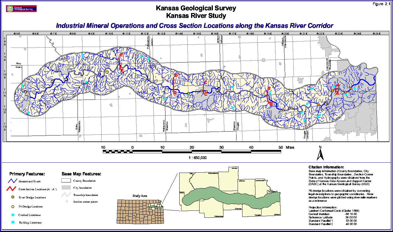
Active crushed-limestone and building-limestone quarries are shown in Figure 2.1. In general, building-stone quarries use thinner beds of stone with little overburden compared to crushed-stone quarries. Numerous abandoned crushed-limestone quarries (nearly 175) also exist along the 12-mile (19.2-km)-wide Kansas River corridor, but these are not shown on the map.
FIGURE 2.1--Location of industrial mineral operators along the Kansas River corridor, and location of cross sections along the Kansas River. A large version (36" by 21" at 72 pixels per inch) is also available. The large-scale picture is 170k and will take some time to download.
Crushed stone is a major component of the Kansas nonfuel mineral economy. Most of the product is made from limestone units of Pennsylvanian and Permian age that are located in the eastern one-third of the state. To demonstrate the importance of crushed stone, Table 2.1 shows the tonnage, value, and per capita consumption (tons per person) for the state. As with any construction-related commodity, year-to-year variations in the quantity of stone used are due to the economy of the state and, like cement and aggregates, particularly the magnitude of highway-department funding for major roads (see Table 2.1). Crushed-limestone aggregate sold/used in 1996 amounted to over $100 million with a consumption of nearly 9.5 tons per person.
Table 2.1--Per capita usage of crushed stone in Kansas.
| Year | Tonnage in Thousands | Population in Thousands |
Value in Thousands | Per capita Use |
|---|---|---|---|---|
| 1920 | 699 | 1,769 | 1,014 | 0.39 |
| 1930 | 1,249 | 1,881 | 1,245 | 0.66 |
| 1940 | 2,881 | 1,801 | 3,673 | 1.60 |
| 1950 | 7,630 | 1,905 | 8,920 | 4.01 |
| 1960 | 11,814 | 2,179 | 15,031 | 5.42 |
| 1970 | 15,161 | 2,249 | 22,406 | 6.74 |
| 1980 | 17,398 | 2,364 | 54,731 | 7.36 |
| 1990 | 20,800 | 2,478 | 79,200 | 8.39 |
| 1991 | 16,802 | 2,491 | 67,249 | 6.75 |
| 1992 | 17,084 | 2,515 | 69,600 | 6.79 |
| 1993 | 20,732 | 2,531 | 90,663 | 8.19 |
| 1994 | 23,624 | 2,554 | 103,416 | 9.25 |
| 1995 | 22,400 | 2,565 | 95,800 | 8.73 |
| 1996 | 24,420 | 2,572 | 106,000 | 9.49 |
Sources: Tonnage and values from the U.S. Bureau of Mines and U.S. Geological Survey annual state mineral yearbook chapters for Kansas. Population figures from the Department of the Census. Per capita consumption calculated at the Kansas Geological Survey.
The Kansas River is the major source of sand and gravel for northeastern Kansas. This fact gives the river special importance because: (1) few construction projects do not involve the addition of crushed stone and sand and gravel aggregates, and (2) nearly 40 percent of the state's population reside in the 10 counties bordering the river.
In general, the Kansas River's bed material is sand and has little mud or clay minerals compared to most rivers. The clean nature of the sand allows nearly all of the dredged material to be used as a commercial product. As a result, river dredges in the Kansas River can produce some of the best-quality, least-expensive sand in the United States. F.O.B. plant prices for concrete sand in major U.S. cities ranged from nearly $3.00 per ton up to $15.00 per ton with a Kansas City price of $3.60 per ton (Engineering News Record, 1997).
Under the present statutes, the State of Kansas receives a royalty of $0.15/ton from sand and gravel operations for dredging in the navigable streams of the state. Sand and gravel dredged from the Kansas River during 1995 and 1996 as reported by the Kansas Department of Revenue is 2,137,982.24 tons for 1995, and 2,377,011.94 tons for 1996. Based on the $0.15/ton royalty, the income to the State was $320,697 in 1995, and $356,552 in 1996.
Most aggregate applications require a mixture of aggregate sizes. In general, the coarser sizes are the least accessible. A general profile of deposited material in the floodplain of the Kansas River involves a top layer of soil or a mixture of soil and silt called overburden. In general, this material cannot be economically used for concrete work although varying amounts may be sold as topsoil or fill material. Below the top zone is a layer of slightly coarser material of silt to very fine sand that often is not usable in significant quantities in concrete. Small amounts of the very fine sand may be suitable for masonry work and fill. The deepest layer extending down to bedrock is usually coarser sand and some gravel material that is needed in large quantities for concrete work. This arrangement of the sediments or alluvium is the common case, but there are many variations. It is not unusual to find zones of clay or silt within the coarser-size zone: thus, not all of the coarse zone may be usable. Whether a dredge is located in the floodplain of the river or in the river, the coarser-sized fractions are what the dredging operation desires as the end product. A river dredge is "closer"; to the desired product than the pit dredge on the floodplain because the latter involves overburden removal, commonly using large scrapers, and excavation to the depth of the water table before a dredge can be moved into place and begin operating.
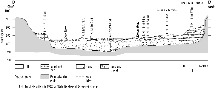
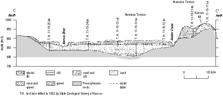
Cross sections, based on borehole logs (Appendix C) show the geology at certain locations along the river floodplain (Figures 2.2-2.6). They show that the source of the alluvium is mostly a combination of Tertiary deposits from the High Plains (western Kansas and eastern Colorado) and glacial outwash contributions from deposits of Pleistocene age. In addition, some areas of the floodplain contain terrace deposits that usually contain large amounts of silt to clay and generally are a poor sand and gravel resource.
Figure 2.2--Cross section A-A'; of the Kansas River, east of Bonner Springs, Kansas. Modified from Dufford (1958, p. 10).
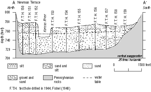
Figure 2.3--Cross section B-B'; of the Kansas River, northwest of Lawrence, Kansas. Modified from Davis and Carlson (1952, pl. 3).
Cross section A-A' (Figure 2.2) is east of Bonner Springs and was reported by Dufford (1958). A feature of the borehole records associated with this profile is the considerable mixed sand and gravel thickness, although most holes also show considerable overburden thickness.
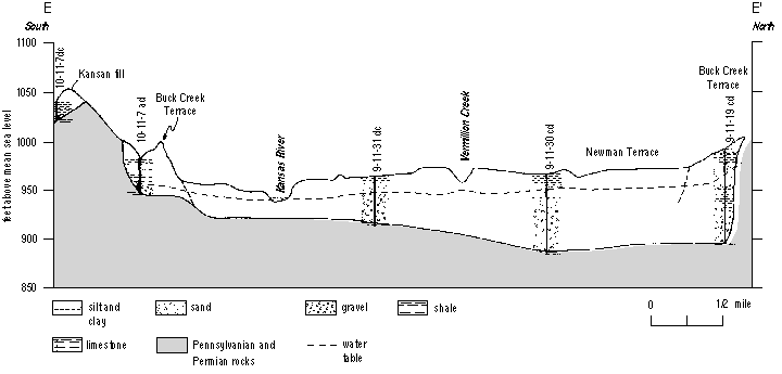
The B-B' cross section (Figure 2.3) is west of Lawrence, reported by Davis and Carlson (1952), and represents one of the widest areas of the Kansas River floodplain. The floodplain area north of the river channel has appreciable overburden and limited thickness of clean, coarse sand and gravel. By contrast, the area south of the river channel includes an old oxbow lake and about 50 feet (15.2 m) of coarse sand and gravel. Cross section C-C' (Figure 2.4), located at Topeka (from Davis and Carlson, 1952), shows potentially usable sand and gravel only on the north side of the river channel but covered by at least 20 feet (6.1 m) of overburden.
Figure 2.4--Cross section C-C'; of the Kansas River at Topeka, Kansas. Modified from Davis and Carlson (1952, pl. 3).
The other two cross sections are reported by Beck (1959). Boreholes in cross section D-D' (Figure 2.5), located between the Kansas River channel northward to Ensign Creek, indicate usable sand and gravel deposits that are about 50 feet (15.2 m) thick with an overburden thickness of less than 15 feet (4.6 m). Farther to the west, cross section E-E' (Figure 2.6) is about 3 miles (4.8 km) east of Wamego. Boreholes approximately 0.5 and 1.5 miles (0.8-2.4 km) north of the Kansas River channel show relatively thick deposits (30-40 feet [9.1-12.2 m]) of medium- to coarse-sized sand and gravel. However, the overburden thickness is approximately 20 feet (6.1 m).
Figure 2.5--Cross section D-D'; of the Kansas River, west of Silver Lake, Kansas. Modified from Beck (1959, pl. 3).
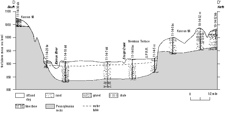
Figure 2.6--Cross section E-E'; of the Kansas River east of Wamego, Kansas. Modified from Beck (1959, pl. 3).
Most sand and gravel is used as an aggregate. As mentioned previously, for industrial mineral purposes, aggregate is defined as any hard, inert material used for mixing with a cementing or bituminous material to form concrete, mortar, asphalt, or similar product, or used alone, as in railroad ballast, road covering, or fill. Sand and gravel along with crushed stone are the two main types of aggregate used in Kansas for a variety of construction work.
One tends to think of sand boxes, occasional landscaping, and street treatment (by itself or mixed with deicing salts) during snowy/icy conditions as uses for sand and gravel, but these applications are minuscule compared to the commodity's application in construction work. The construction sand and gravel industry is driven by concrete work, with at least half of the production from northeastern Kansas being used as aggregate in concrete. One cubic yard of concrete contains 1,500 to 2,000 pounds (680-910 kg) of sand and gravel, the exact amount depending on the application and job specifications. A lesser amount, over 20% of the production from northeastern Kansas, is used for aggregate in asphalt (Table 2.2).
Table 2.2--Percent sand and gravel usage in northeastern Kansas: 1984-1994.
| Use | Percent |
|---|---|
| Concrete Aggregate | 50 |
| Asphalt Aggregate | 21 |
| Fill Sand | 14 |
| Road Base/Covering | 11 |
| Other | 4 |
Sources: U.S. Bureau of Mines, U.S. Geological Survey, Kansas Aggregate Producers Association, and individual producers.
Although not nearly as large in tonnage as construction sand and gravel, another important product obtained from the Kansas River system is industrial sand. At present, two companies in the Kansas City area produce this commodity. Industrial sand is primarily used in the production of fiberglass and to a lesser extent for sandblasting applications. For fiberglass production the sand is first passed through a magnetic separator to remove the iron-rich magnetic particles in the sand.
Three major sources for sand and gravel located in Kansas are the Kansas, Arkansas, and Missouri river systems. The Kansas River supplies the majority of the sand and gravel for northeastern Kansas, including the densely populated Topeka-to-Kansas City corridor. Including the Republican, Smoky Hill, and Big Blue Rivers, the Kansas River and tributaries annually supply well over 3 million tons per year, most of the sand and gravel for the northeastern and north-central portions of Kansas. The Missouri River also supplies sand and gravel for northeastern Kansas. This sand contains a small amount of lignite that must be removed, at an additional processing cost, before the aggregate is suitable for smooth finish or durable concrete work. Other sources of sand and gravel from Kansas waters are the Walnut River and occasionally gravel bars located in the Neosho River. Finally, a large amount of sand and gravel is produced from dry pits in western Kansas, particularly in the northwestern portion, where there are no major rivers.
The Kansas River corridor supplies sand and gravel from river dredges that extract sand from the bed of the river and pit dredges that extract sand from deposits along the river floodplain. For purposes of this report, the Kansas River has been divided into two sections: (1) Kansas City to Topeka, the lower Kansas River, and (2) west of Topeka to Junction City, the upper Kansas River.
It is not surprising that the Kansas City to Topeka section of the river has undergone extensive study, particularly the lower portion between Kansas City and Lawrence. This includes the metropolitan area of Kansas City where a high demand for construction sand and gravel exists. The large construction industry in the area utilizes sand dredged from both the Kansas and Missouri rivers. The Kansas River product is cleaner and therefore has a cost advantage over the equivalent Missouri River product that requires special cleaning due to the presence of undesirable amounts of lignite. Even after treatment, a small amount of lignite remains in the Missouri River sand. Some consumers, depending on the application, prefer to use sand from the Kansas River over Missouri River treated sand.
The U.S. Army Corps of Engineers (USACE) has studied much of the Kansas River and is the agency that permits dredging within the river. Burns & McDonnell (1986) did much of the work for the Corps that led to the regulatory plan of the USACE (1990) that was implemented gradually between 1991 and 1994. These studies were concentrated on the portion of the river between Kansas City and Lawrence where production tonnages were large. The Burns & McDonnell report used drill records from various sources to construct a series of maps along this section of the river that showed contours of overburden thickness, intermediate zones, and zones of usable, coarser sand and gravel suitable for concrete.
Based on cross sections at many locations along the river from 1977 and later, the USACE realized that the elevation of the river bed was declining substantially, and that previously buried structures such as pipelines and bridge piers were being exposed. Overall, the drop in the bed elevation is caused, in part, by the reservoir system, which not only minimizes flooding but also limits recharge of the river bed. On a localized scale, extensive dredging could lower the elevation of the river bed. To slow the bed lowering and to minimize the likelihood of damage to underground structures, the USACE began to restrict dredging with respect to annual production from a given permit as well as the collective amounts produced annually from a given section or reach of the river. While some dredge sites were not appreciably affected, some sites in the Kansas City area were sharply curtailed. At least two dredge sites that each produced approximately one million tons per year suddenly had their production reduced to 300,000 tons per year. A summary of the reaches of the river and their production limits as established by the USACE, current dredging permits (zones of river miles), their activity status, and the October 1997 dredge locations are given in Table 2.3.
River profiles obtained by the U.S. Army Corps of Engineers during 1995 showed that most of the profiles were changed, sometimes dramatically, by the 1993 flood. Some areas of the channel were filled by deposition while other areas underwent additional scouring. The dramatic change in river profiles in such a short period suggests that the 1993 flood may have had more impact on the river-bed elevation than the previous 15 years of dredging, except for zones that have undergone extensive dredging in the lowest portions of the river.
Based on geology, drill records, and related data, the Kansas City to Lawrence area of the Kansas River strongly favors river dredging over pit dredging in the floodplain. The width of the Kansas River floodplain throughout the majority of this section of the river is relatively narrow (as little as 0.9 miles [1.4 km] near the Turner Bridge), and restricts the amount of land potentially available for pit dredges in this area. In addition, agricultural and industrial usage, pipelines, railroad tracks, utility lines, etc. restrict even more the land in the floodplain available for dredging. Also, considerable overburden must be removed in much of this area. These factors will be discussed later in the section of this report dealing with production costs. The possible exception is the area just east of Lawrence to approximately the Douglas County line.
Information on the Lawrence-to-Topeka stretch of the lower Kansas River is available from drill records at the Kansas Geological Survey and drill records from the Kansas Department of Transportation and from private drilling companies. Although contour maps have not been constructed showing thicknesses of overburden, etc., the average overburden thickness and depth to the water table is appreciable in many areas as shown by Blechinger (1997).
Table 2.3--(Part 1) Reaches of the Kansas River and the total annual production per reach as defined by the U.S. Army Corps of Engineers; and (Part 2) Location of present river-dredging permits by river miles, activity status, and dredge location as of October 1997. Locations shown on Figure 1.1.
| Reach | River Miles | Annual Total Production Allowed (top line) and Company, Permits (), and Tonnage |
|---|---|---|
| 1 | 00.0-21.2 | 1,000,000 tons Kaw Valley Sand & Gravel (2) 250,000 tons Holliday Sand & Gravel (3) 450,000 tons Builder's Sand (1) 300,000 tons |
| 2 | 21.2-48.0 | 750,000 tons per 15 miles* Builder's Sand (1) 250,000 tons Holliday Sand & Gravel (1) 250,000 tons Kaw Sand (4) 450,000 tons Penny's Concrete (1) 300,000 tons |
| 3 | 48.0-51.8 | 150,000 tons Penny's Concrete (1) 150,000 tons |
| 4 | 51.8-170.4 | 750,000 tons per 15 miles Kansas Sand (1) 250,000 tons Victory Sand (1) 250,000 tons Meier's Ready-Mix (1) 250,000 tons |
*The values in reach 2 are restricted because of the 750,000 tons per 15-river-miles limit. That is why Kaw Sand, despite having four permits, does not have a larger cumulative total.
| Location (River Miles) | Company | Activity Status | Dredge Location (River Mile) |
|---|---|---|---|
| 9.4-10.4 | Kaw Valley | Inactive | None |
| 12.8-13.9 | Kaw Valley | Active | 13.7 |
| 15.4-16.9 | Holliday | Active | 16.0 |
| 17.5-18.4 | Holliday | Inactive | None |
| 19.1-20.6 | Builder's | Active | None |
| 21.0-21.15 | Holliday | Active | 21.0 |
| 26.1-27.6 | Kaw Sand | Inactive | None |
| 29.2-30.2 | Holliday | Active | None |
| 31.1-31.9 | Builder's | Active | 31.5 |
| 35.4-36.4 | Kaw Sand | Active | None |
| 42.6-44.1 | Kaw Sand | Inactive | None |
| 45.2-46.7 | Penny's | Active | 46.0 |
| 47.1-48.0 | Kaw Sand | Active | None |
| 49.6-51.35 | Penny's | Active | 49.0 |
| 84.5-85.8 | Kansas | Active | 85.0 |
| 86.3-86.5 | Victory | Active | 86.4 |
| 90.1-91.6 | Meier's | Active | 91.3 |
The floodplain of the river is wider, thus giving rise to the possibility of available land for floodplain dredging. However, the majority of the land is currently farmed and of questionable availability for pit dredging. This fact, coupled with overburden thickness and depth to the water table, make pit dredging in the floodplain questionable except for certain areas.
The upper portion of the Kansas River begins at Junction City and flows eastward toward Topeka. This portion of the river is the most likely zone for successful pit dredging. Much of the area contains a wide floodplain, thus giving rise to the possibility of more available land. Industrial usage and cost of the land are less, relative to lower portions of the river. In general, the overburden thickness is less and the water table in places is more shallow relative to the lower portions of the river.
At present, no river dredges are active west of the the Topeka area. The westernmost river dredge is at river mile 91, a few miles west of Topeka.
All river-dredging permits are granted by the USACE while pit or floodplain dredge operations are granted by the State Conservation Commission with approval from the respective county commissions. In both cases, public hearings are held to give any interested or concerned citizen a chance to express opinions.
Seventeen river-dredging permits (Figures 1.2 and 2.1, and Table 2.3) have been granted by the USACE, but not all are actively being dredged at a given time. A river dredge may work part of the year on one permit and another part of the year on another permit. In one case, two dredges are used on one permit by one company, but only one dredge is used at any given time. In another case, two permits are worked by one dredge during different parts of the year with the two permits belonging to different companies. As of October 1997, nine dredges operated on the river (Figure 2.1), seven pit dredge locations within the floodplain or alluvium. An eighth pit dredge is located on the western edge of the river corridor on the floodplain of the Smoky Hill River. Approximately 100 sand and gravel operations along the river corridor, most of which were pit dredges on the floodplain, are now abandoned.
Few people realize the time and expense associated with setting up a river- or pit-dredging operation. In parts of northwestern Kansas, production may be as simple as scooping up the product with a front-end loader, placing it in a dump truck, and hauling the product to a site or readymix plant where it will be used, perhaps after some screening to obtain the desired product sizes. Except for sand and gravel obtained from pit dredges located in the Arkansas River floodplain, dry pits also are typical in southwestern Kansas. By contrast, nearly all of the sand and gravel production in northeastern Kansas involves pit or river dredges on the Kansas River system including its tributaries.
All producers face many expenses associated with obtaining a permit to dredge for sand and gravel. Items such as environmental impact statements and site plans, including any proposed road or bridge construction, must be provided before a permit is approved. In addition, before a permit is filed, the producer must consider the available resources and whether land is available for a plant site. A farmer, whose livelihood depends on crops from the floodplain, may not be interested in selling the land, regardless of the price. Even if land is available for a sand and gravel operation, it is not unusual for two or three years to elapse before a permit is finally approved.
A pit-dredge operation on the floodplain is initially much more expensive than a river dredge. Producers on the lower portion of the Kansas River estimate that a pit dredge in many areas would produce sand that costs about 50% more than a river dredge. A producer on the Missouri River suggested sand from a floodplain dredge at his location would cost 50-60% more than sand from a river dredge (Missouri Department of Natural Resources). No floodplain producer will set up an operation without incurring expenses associated with drilling to ensure adequate reserves are present. Costs also are associated with bonding required by the State Conservation Commission. While both need land for a plant site, the floodplain operation must acquire considerably more land for purposes of overburden stockpiles as well as for the actual dredge operation. The consensus among producers is that a minimum of 100 acres is needed for a pit-dredge operation to be economically viable. After the floodplain operation has exhausted the sand supply in the pit, expenses associated with reclamation occur. Depending on the location, reclamation costs may be offset by selling the pit area to a developer.
Mr. Vernon Dow, a professional geologist with Dow Geological Services, Topeka, Kansas, has listed factors that must be considered, besides capital equipment expenditures, in determining the economics of a floodplain operation. This list includes (Vernon Dow, personal communication, 1997):
With all these variables, it is difficult to compare pit- versus river-dredging costs. Such comparison must be made on a case by case basis, at a specific site.
In an effort to locate potentially suitable pit-dredge sites, the Kansas Geological Survey examined water-well logs of the entire floodplain of the Kansas River. Both the overburden thickness and sand and gravel thickness were recorded. Some sections have no wells while other sections may have 10-20 wells; for the latter, averages were used. The key to determining the suitability of the site is the ratio between the overburden and the usable sand and gravel, the latter often referred to as the pay zone. While plenty of thick sand deposits are present in the river's floodplain, it will not be dredged if covered by too much overburden. Also, some locations have very little overburden, but unfortunately have relatively thin pay zones.
Blechinger (1997), in a study on the sand and gravel industry along the Kansas River, evaluated the majority of the water-well logs at the Kansas Geological Survey and determined the average overburden ratios (cubic yards of overburden per ton of underlying sand) for each section (one square mile) along the entire Kansas River floodplain. Through a series of calculations involving the factors that affect cost, he identified 74 potentially profitable floodplain-dredging sections whose overburden ratios are less than 0.16. Throughout the study, a gross profit margin of 5% was required for a site to be suitable. As shown below, a large number of potential sites exist in the upper portion of the Kansas River, but not many sites in the lower part. This study is based solely on well logs and does not attempt to determine whether any or all of the sites have been used in the past or present for sand and gravel. Further, no attempt was made to assess the quality of the well log, actual sand-size distribution in the pay zone, land availability, etc. The number of potential sites in parentheses by county are: Geary (1), Riley (3), Pottawatomie (20), Wabaunsee (10), Shawnee (19), Jefferson (4), Douglas (8), Leavenworth (1), Johnson (5), and Wyandotte (3). The majority (49) of the potential sites are located in Pottawatomie, Wabaunsee, and Shawnee counties where the floodplain is very wide.
It is difficult to determine the amount of sand and gravel that will be needed in the future, but the historical record provides a general trend. The commodity depends upon the economy of the state and highway funding. Generally, a strong economy generates the tax dollars to fund highway programs. The average per capita consumption by decade since 1910 as well as the average of 1990-1995 and 1996 for Kansas is shown in Table 2.4. In general, the state's population gradually increases and until recently, production (tonnage) and per capita consumption also increased. During the early 1990's, production of both crushed stone and sand and gravel declined. In 1996, production of both types of aggregate increased sharply over 1995 due to a healthy economy with both strong highway and building construction.
Table 2.4--Average sand and gravel consumption per decade, last five years, and 1996.
| Years | State Population (000's) |
State Tonnage (000's) |
Value (000's) | Per Capita |
|---|---|---|---|---|
| 1910-1920 | 1,730 | 1,057 | 281 | 0.61 |
| 1920-1930 | 1,825 | 2,174 | 1,265 | 1.19 |
| 1930-1940 | 1,841 | 2,305 | 977 | 1.25 |
| 1940-1950 | 1,853 | 4,520 | 2,548 | 2.44 |
| 1950-1960 | 2,042 | 9,898 | 6,549 | 4.85 |
| 1960-1970 | 2,214 | 11,938 | 8,989 | 5.39 |
| 1970-1980 | 2,306 | 12,651 | 17,001 | 5.49 |
| 1980-1990 | 2,421 | 12,313 | 27,637 | 5.09 |
| 1990-1995 | 2,516 | 11,539 | 26,690 | 4.59 |
| 1996 | 2,572 | 14,850 | 38,500 | 5.77 |
Sources: Population figures were obtained from the Census Bureau. Tonnage and value were obtained from the annual mineral yearbook chapters for Kansas published by the U.S. Bureau of Mines and the U.S. Geological Survey.
During 1996, the Kansas Department of Transportation (KDOT) used approximately 25% of the sand and gravel production from the Kansas River corridor. Excluding maintenance applications such as road patching and de-icing sand, KDOT used over 700,000 tons of sand and gravel in 1996 to produce concrete and asphalt roads in northeastern Kansas (Lon Ingram and Mick Lackey, personal communication, 1998). Concrete work used 386,000 tons of sand and gravel valued at $11.4 million and represents the equivalent of a two-lane U.S. highway (24 feet [7 m] wide, 9 inches [22.5 cm] thick) about 112 miles (6.7 km) long.
Another important factor that should guarantee a relatively strong, long-term demand for aggregates is the gradual increase in population and percent of the state's population associated with the 10-county area bordering the Kansas River. At present, nearly 40% of the state's population lives in the 10-county area with a little more than one-quarter living in Shawnee, Douglas, and Johnson counties. During the 16-year period between 1980 and 1996, the overall population increase for Kansas was nearly 9% while the 10-county area increased nearly 20% (Table 2.5).
Table 2.5--Sand and gravel consumption and population for 10-county area along the Kansas River relative to the total production and population for Kansas, 1986-1996.
| Year | Total Tons from the 10 Counties |
Total Tons Produced in State |
10-County Percentage | |
|---|---|---|---|---|
| Tons | People | |||
| 1984 | 3,399,592 | 11,796,203 | 28.8 | 36.6 |
| 1986 | 6,079,425 | 15,609,428 | 38.9 | 37.4 |
| 1988 | 3,036,369 | 10,759,726 | 28.2 | 38.3 |
| 1990 | 2,134,772 | 10,862,690 | 19.6 | 39.0 |
| 1992 | 2,983,828 | 11,979,016 | 24.9 | 39.3 |
| 1994 | 2,470,858 | 12,316,080 | 20.1 | 39.6 |
| 1996 | 3,200,000 est. | 14,850,000 est. | 21.5 | 39.6 |
Sources: Tonnages from the annual yearbook chapters for Kansas published by the U.S. Bureau of Mines and the U.S. Geological Survey.
Based on projections or estimates, there is no reason to question the general trend, namely, that the 10-county area will continue to grow faster than the state as a whole for some time (Table 2.6). Figures suggest that by 2025, nearly half of the Kansas population will reside in the 10 counties bordering the Kansas River. The increased population of the Kansas River corridor should create greater construction demands for the area and hence, relatively strong demand for sand and gravel. Planners and related decision-makers need to ensure that adequate supplies of sand and gravel as well as crushed stone are available to meet future demands for aggregates in this area.
Table 2.6--Projected populations for Kansas and the 10 counties bordering the Kansas River and percent of the Kansas population residing in the 10 counties.
| Year | Kansas Population | 10-county Population | Percent |
|---|---|---|---|
| 2000 | 2,562,890 | 1,109,769 | 43.3 |
| 2005 | 2,604,664 | 1,170,956 | 45.0 |
| 2010 | 2,645,887 | 1,219,057 | 46.1 |
| 2015 | 2,688,165 | 1,263,637 | 47.0 |
| 2020 | 2,723,689 | 1,302,197 | 47.8 |
| 2025 | 2,754,617 | 1,330,057 | 48.3 |
| 2030 | 2,780,613 | 1,341,509 | 48.2 |
Sources: Population figures are from the Census Bureau.
As mentioned earlier, the only prominent river sources of sand and gravel for Kansas are the Missouri, Kansas, and Arkansas river systems. Tributaries of the Kansas River, notably the Big Blue, Republican, and Smoky Hill rivers, have provided or are now providing some sand and gravel. However, the latter resources are limited to the lowest portions of these tributaries where their floodplains are the widest or their channels contain sufficient resources to support dredging activities. Occasional intermittent operations are associated with gravel bars in the Neosho River and recently a permit was granted for sand extraction from the Walnut River in south-central Kansas. The Missouri River provides much sand to the metropolitan Kansas City area while numerous pit dredges along the Arkansas River supply sand for the Wichita area and much of southwestern Kansas.
Before considering alternate sources for northeastern Kansas, such as the Arkansas River or out-of-state products, one must consider transportation, a major cost associated with sand and gravel from alternate sources. It costs an average of $0.10/ton mile to deliver a load of sand and gravel, but the cost may vary from as low as $0.08/ton mile to a maximum of $0.25/ton mile. Charges vary according to distance, roads traveled, and destination area. The highest transportation charges are associated with city driving because of the costs of driving in a congested area compared to normal highway driving. To transport a load of sand from one side of Johnson County to the other side may double the cost of the sand. In addition, long hauls tie up trucks that could be used to make two or three short hauls. As a result, under existing conditions most producers do not generally haul sand more than 50 miles (80 km) in a north or south direction. Because the Kansas River runs east to west and several producers are located in the lower portion of the river, hauling limits will be less than 50 miles (80 km) in the east-west direction. The Kansas Aggregate Producers' Association estimates that many producers can remain competitive up to a 30-mile (48-km) radius from their plant. Exceptions may occur where a destination may not have any nearby resources and may be willing to pay the transportation costs. For example, Springfield, Missouri, has been known to acquire sand from the Kansas River, but the transportation costs make the sand price range from $15.00 to $20.00/ton.
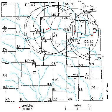
A simple way to demonstrate possible hauling distances is to draw arcs with a 50-mile (80-km) radius from different potential sources. A map of eastern Kansas with circles of 50-mile (80-km) radii from existing floodplain sources shows that northeastern Kansas is relatively well covered by existing floodplain operations along the Kansas River from a location standpoint, although certainly not with respect to tonnages required to meet construction demands of the area (Figure 2.7). Furthermore, sand with the same price per ton from the nearest alternate source on the Arkansas River would not be competitive, because of the much greater distance.
Figure 2.7--Map of eastern Kansas with arcs of 50-mile (80-km) radius from existing pit-dredging operations. A larger version of this figure is also available.
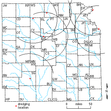
The map also indicates that river dredges by themselves (the westernmost river dredge is just west of Topeka) cannot supply the western portion of northeastern Kansas without exceeding the 50 miles (80 km); the additional hauling costs would increase the price of sand to the point that operations from part of the Arkansas River would be competitive with sand from the Topeka area. If sand and gravel were supplied by sources other than the Kansas River, namely the Smoky Hill, Republican, Big Blue, and Missouri rivers.; the Topeka area would not be covered within the 50-mile (80-km) hauling limit, and construction jobs would cost more due to increased transportation costs (Figure 2.8). The Missouri River sand, even with most of the lignite removed, is not always desirable for some jobs, and there would be large transportation costs to haul sand to most of the area. Most important, it is unlikely that the tributaries of the Kansas River could supply the necessary tonnages to support construction activity throughout northeastern Kansas.
Figure 2.8--Map of eastern Kansas with arcs of 50-mile (80-km) radius from existing operations other than the Kansas River. A larger version of this figure is also available.
Beck, H. V., 1959, Geology and ground-water resources of Kansas River valley between Wamego and Topeka vicinity: Kansas Geological Survey, Bulletin 135, 88 p. [available online]
Blechinger, E. T., 1997, An analysis of sand mining alternatives along the Kansas River basin: Kansas Geological Survey, Open-file Report 97-66, 86 p.
Burns and McDonnell, 1986, Kansas River floodplain sand and gravel investigations for the regulatory plan, commercial sand and gravel dredging, Kansas River: Report prepared by Burns and McDonnell for the U.S. Army Corps of Engineers
Davis, S. N., and Carlson, W. A., 1952, Geology and ground-water resources of the Kansas River valley between Lawrence and Topeka, Kansas: Kansas Geological Survey, Bulletin 96, Part 5, p. 203-276 [available online]
Dufford, A. E., 1958, Quaternary geology and ground-water resources of Kansas River valley between Bonner Springs and Lawrence, Kansas: Kansas Geological Survey, Bulletin 130, Part 1, 96 p. [available online]
Engineering News Record, 1997, Comparison of sand prices for major cities in the central United States: Engineering News Record, v. 279, no. 9, p 23-24
Floerchinger, T., 1992, Kansas population projections, 1995-2030: Kansas Division of the Budget, cited in 1995 Kansas Statistical Abstract, Population, p 2-31 to 2-33
U. S. Army Corps of Engineers, 1990, Commercial dredging activities on the Kansas River, Kansas: Final Regulatory Report and Environmental Impact Statement, Appendix A, 28 p.
U. S. Army Corps of Engineers, 1995, Unpublished cross sections along the Kansas River between 1972 and 1995
U.S. Bureau of the Census, 1996, Estimates of the population of counties: U.S. Bureau of the Census, Population Estimates Program, Population Division and Estimates of the Population of Counties 1980-1995
Previous Page--Development and General Geology || Next Page--Fluvial Hydraulics and Sediment Transport