New Bulletin Revises Stratigraphy
A new KGS bulletin modifies the way some rocks in eastern Kansas
are classified and named. These Pennsylvanian rocks, deposited about 300
million years ago, crop out across Kansas in a band roughly 30 miles wide
from Kansas City through Independence, and extend into Missouri and Oklahoma.
These revisions are based on field work and subsurface drilling along
this outcrop belt. Phil Heckel, University of Iowa, and Lynn Watney, KGS,
collaborated on the bulletin, which should provide a more consistent framework
within which to interpret geologic history and address problems involving
resource appraisal and environmental issues. Copies of Bulletin 246, Revision
of Stratigraphic Nomenclature and Classification of the Pleasanton, Kansas
City, Lansing, and Lower Part of the Douglas Groups (Lower Upper Pennsylvanian,
Missourian) in Kansas, are available from the Kansas Geological Survey,
1930 Constant Avenue, Lawrence, KS 66047-3726 (or call 785-864-3965) for
$20.00, plus tax, shipping, and handling, the web
site or email.
Shawnee County Geologic Map Updated
An updated version of the Shawnee County geologic map is now available
from the Kansas Geological Survey. Originally published in 1967 by the
U.S. Geological Survey (USGS), the map is based on field work done in
the late 1950’s by USGS geologists William D. Johnson, Jr., W. L.
Adkison, and Holly C. Wagner, with the assistance of H. J. Hyden. The
original map has been out of print for several years. The new map combines
the 1950’s interpretation of geology with an updated base map.
Most of Shawnee County is in the glaciated region of Kansas and is characterized
by deposits of silt, gravel, and boulders that were left behind by the
glaciers that covered northeastern Kansas about 600,000 years ago. These
glacial deposits cover much older limestones, sandstones, and shales that
were deposited during the Pennsylvanian Period of geologic time, nearly
300 million years ago. Because geologic maps show the rock units likely
to be encountered at or near the surface, they are useful in construction,
in understanding soils, in searching for water and mineral deposits, and
in a variety of engineering and environmental applications.
The updated map, produced in full-color, is drawn at a scale of 1:50,000 (one inch on the map equals about 3/4 mile). Copies of the new map are available from the KGS at the above address, phone number, or web site. Copies are $15.00, plus tax, shipping, and handling.
New
Publications
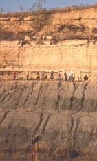
Trace fossil from Bulletin 245.
Maps,
census data, political districts—it is no longer enough to provide
this information. For many users, these data must be in digital form and
easily available.
In Kansas, the Survey’s Data Access and Support Center (or DASC)
is an arm of state government that serves as a source of all sorts of
digital information, receiving national recognition in the process.
DASC was created in 1989, largely with funding from the state water plan,
to receive, archive, and distribute digital data. At the outset, DASC’s
primary purpose was to make sure that state agencies got the data they
needed in the digital format that worked best. DASC still serves that
function, making available a range of data bases (at http://www.kansasgis.org/).
Private businesses and citizens also use the data bases, along with other
features such as interactive maps that are hosted on the DASC web site.
DASC is directed by the GIS (Geographic Information Systems) Policy Board,
which consists of the directors of the major state, federal, and local
agencies that use GIS technology. Under that direction, DASC has helped
make Kansas a leader in the realm of digital data. For the past two years,
state government in Kansas tied for first nationally in the GIS and Transportation
category of the Center for Digital Government—Digital State Survey.
That expertise has led to partnerships between DASC and other agencies, particularly in the development of new GIS applications over the web. DASC has collaborated with, among others, the Kansas Department of Health and Environment, the Kansas Applied Remote Sensing Center, the Kansas Bureau of Investigation, the Kansas Deptartment of Wildlife and Parks, the Kansas Corporation Commission, Douglas County, and the Kansas State Historical Society.
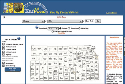
Working with other state agencies, DASC developed the “Find My Elected Official” web site
(http://maps.kansasgis.org/demograph/ims/myelect.cfm).
Data Access and Support Center
URL:http://www.kgs.ku.edu/Publications/GeoRecord/2003/vol9.1/Page3.html