Mining, High Plains Aquifer Subjects
of New Circulars
Lead and zinc mining in the Tri-State mining district in southeastern
Kansas is the subject of a new Public Information Circular. Lead and
Zinc Mining in Kansas (PIC
17) explains the history and geology of the region, which was once
one of the world’s major lead and zinc mining areas. The circular,
by Liz Brosius and Robert Sawin, also looks at the environmental consequences
of 100 years of mining and the efforts to solve some of the problems and
reclaim the land.
Another new circular (PIC
18) provides an overview of the High Plains aquifer, the most important
water source for much of western and central Kansas. The High Plains
Aquifer, by Rex Buchanan and Robert Buddemeier, describes the High
Plains aquifer, which includes the well-known Ogallala aquifer, and discusses
the effects of decades of large-volume pumping and some responses to water
issues in central and western Kansas.
Copies of both PIC 17 and 18 can be obtained free of charge by contacting
Publications Sales at the KGS.
These circulars also are available electronically through the Survey’s
web site at www.kgs.ku.edu.
Comanche County Geologic Map
The first detailed map of the geology of Comanche County, in southwestern
Kansas, was released recently by the KGS. The new, full-color map is by
Survey geologist James McCauley. It depicts the age and type of rocks
at the surface of Comanche County, along with a variety of other information.
Geologic maps are a basic tool to understanding the geology of an area,
and are useful in environmental issues, construction, mining, and for
other purposes.
Of particular note in Comanche County are the geologic features known
as redbeds—sandstones, siltstones, and shales that are generally
red or orange and have given the name “Red Hills” to this
part of Kansas. The map is drawn at a scale of 1:50,000 (one inch on the
map equals about 0.8 of a mile of actual distance). The cost of the new
map is $15.00, plus $4.00 postage and handling. Kansas residents should
add 6.9% sales tax on the cost of the entire order.
Copies of the above publications are available from the Kansas Geological Survey, 1930 Constant Ave., Lawrence, KS 66047 (phone: 785-864-2157; email: pubsales@kgs.ku.edu).
New
Publications
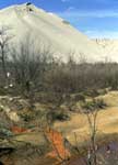
Water contaminated by iron sulfide flows from tailing piles in the Tri-State district.
I n the summer of 2001, one of the state’s best-known geologic landmarks took a tumble. Or part of it did. One spire of Castle Rock, a chalk monument in eastern Gove County, collapsed following a July thunderstorm.
Castle Rock is composed of Cretaceous-age Niobrara Chalk, deposited about 80 million years ago, and stands just north of a more extensive outcrop of chalk capped by the much younger Ogallala Formation. Towering about 70 feet above the plain of nearby Hackberry Creek, Castle Rock was a landmark along the old Butterfield Overland Despatch stagecoach route. Castle Rock is on private property, but the landowner generally welcomes visitors.
July’s rockfall was no big surprise. In a
1992 article in the journal Kansas History, Survey authors James
McCauley, John Charlton, and Rex Buchanan predicted that “the tallest
spire may be the next to fall.” In fact, the collapse at Castle
Rock was one in a series of erosional events in the chalk beds. Erosion
felled a feature called the Sphynx at Monument Rocks in western Gove County
(in 1986) and Cobra Rock, a chalk spire in the outcrop south of Castle
Rock (in 1998). But other chalk monuments remain, and wind and rain continue
to sculpt new ones as the process of erosion goes on.
Erosion Happens
One spire of Castle Rock, a chalk monument in eastern Gove County, collapsed following a July thunderstorm
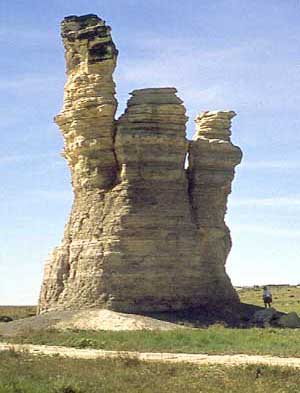
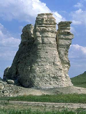
Left: Castle Rock, 1992, right: Castle Rock, 2001.
URL:http://www.kgs.ku.edu/Publications/GeoRecord/2001/vol7.3/Page3.html