Fall 2000
Vol. 6.3
| |
||
| Kansas Geological Survey | Fall 2000 |
Vol. 6.3 |
|
High Plains Aquifer Atlas
CONTENTS High Plains Aquifer–page 1 |
Water
is an issue across all of Kansas, but nowhere is it more important than
the western end of the state where precipitation is low and surface water
is rare. Fortunately, a vast source of underground water—the High
Plains aquifer—occurs under much of central and western Kansas.
The High Plains aquifer is a large, water-saturated body of sand, gravel,
silt, and clay that underlies parts of eight states, including portions
of western and central Kansas. The High Plains aquifer is generally identical
to the Ogallala Formation (and is sometimes called the Ogallala aquifer),
but in some areas it includes other formations that are hydrologically
connected to the Ogallala. Several decades of intensive irrigation have significantly depleted the
High Plains aquifer in many areas. To better understand the aquifer and
issues related to it, the Kansas Geological Survey, under a contract with
the Kansas Water Office, is publishing a non-technical comprehensive atlas
on the Kansas portion of the High Plains aquifer. An Atlas of the
Kansas High Plains Aquifer targets water users, government agencies,
water managers, legislators, and others involved in developing policy
and making decisions about water in Kansas. This atlas focuses on ground
water and related water-resource issues in the High Plains aquifer in
western and central Kansas. A web-based version of the Atlas is online
at www.kgs.ku.edu/HighPlains/atlas. “The printed Atlas is a snapshot of the web-based version, which
will continue to be updated,” said Bob Buddemeier, the Survey’s
project manager for the High Plains Aquifer Evaluation Project. “The
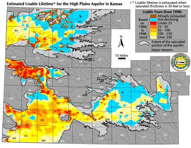
web version will keep maps and discussion current as data are added.” Of particular interest is the section that estimates the usable life of the aquifer for high-volume pumping. These maps project how many years it will take to deplete certain regions of the High Plains aquifer, based on historical usage, and show many areas with less than 25 years of high-volume use left. In some areas the aquifer has already been exhausted for irrigation purposes. Buddemeier warns that these maps need to be understood and used with
caution. “These maps do not predict aquifer depletion. Rather they
show the probability of problems developing in certain areas of the aquifer—what
might happen if past rates and patterns of use continue. We’re trying
to get people to think differently about the aquifer—to look at
trends, not specifics.” To emphasize this point, the Atlas contains estimated usable lifetime maps based on water use during two different periods: 1978–1988 and 1988–1998. Because of changes in weather trends and irrigation methods, depletion patterns changed from one time period to the next, and will continue to change. “What we can’t predict is what nature and people will do in the future,” says Buddemeier. The Atlas contains 23 maps, including maps depicting the water-saturated
thickness of the aquifer, ground-water-quality, and annual ground-water
recharge. The Atlas also includes information and maps on water storage,
availability, accessibility, usage, changes necessary for sustainability,
and how the aquifer interacts with surface water. Supplementary information
explains ground-water terminology and concepts, and a glossary of hydrologic,
geologic, and environmental terms also is provided. The printed version of the Atlas (Educational Series 14) will be available in the fall of 2000 from KGS Publications Sales (pubsales@kgs.ku.edu) for $15.00, plus tax, shipping and handling. |
|
Estimated usable lifetime (1988-98 trend) for the
High plains aquifer in Kansas. |
 |
| Online February 10, 2003 Comments to: lbrosius@kgs.ku.edu Kansas Geological Survey URL:http://www.kgs.ku.edu/Publications/GeoRecord/2000/vol6.3/Page1.html |